GLONASS
Latest
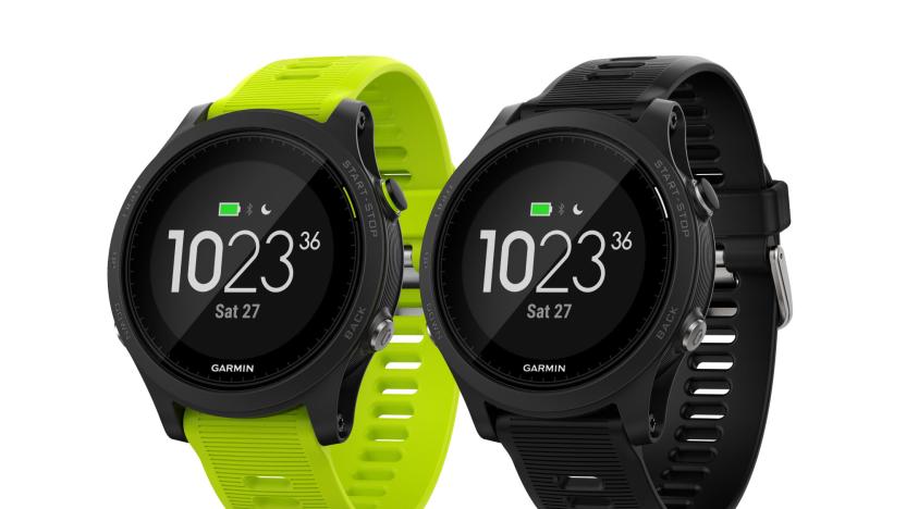
Garmin's Forerunner 935 smartwatch knows how hard you work out
Two months after updating its Fenix line of multisport fitness watches at CES, Garmin revealed its latest GPS-enabled timepiece, the Forerunner 935. However, unlike the Fenix family, which was designed more for general outdoor adventuring, this new tracker is built specifically for serious athletes looking to get the most out of their training.

China gives its homegrown GPS rival another big push
Alibaba has teamed up with Norinco, a Chinese arms manufacturer, to roll out global positioning services using China's homegrown alternative to GPS. The two companies have sunk roughly $310 million into a new joint venture that'll harness Beidou's navigation satellites to provide mapping data to local businesses. It's another big step on the road to the country ending its reliance upon GPS, and comes two years after the service was opened up to heavy-duty transport vehicles and smartphones. It may not affect us outside of Asia-Pacific just yet, but with Beidou set to become available for all global users by 2020, it's worth keeping an eye on how good this new-fangled offering turns out to be. [Image Credit: ChinaFotoPress via Getty Images]
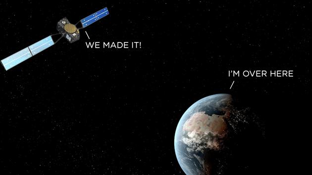
Europe launches two navigation satellites into the wrong orbit
Arianespace, the company that launches satellites for the European Union, has had to concede that its latest mission hasn't been a complete success. Friday's launch conveyed two satellites, Dorea and Milena, into orbit to help build out Galileo, the EU's homegrown alternative to GPS and GLONASS. Everything had gone to plan when the Soyuz rocket reached the upper atmosphere and deployed the satellites, but shortly after, authorities realized that the units were in "noncompliant orbit," which means they're spinning around the planet in the wrong orbit.
Defense bill makes US-based Russian satellite monitoring stations 'next to impossible' due to spying fears
The State Department hoped the building of satellite monitoring stations might soften tempers between the US and Russia, which have flared in the wake of asylum for Edward Snowden and arguments over Syrian politcs. Congressional Republicans, the Pentagon and the CIA, on the other hand, had different ideas, suggesting that US-based stations built to support Global Navigation Satellite System (GLONASS) - the Russian equivalent to GPS - could help the country's spying efforts. And now language included in a defense bill signed by President Obama late last week likely marks the end of the project - for now, at least. An anonymous Republican aide told The New York Times that, "the idea was to make it next to impossible, if not impossible, to do this," essentially removing the State Department from the process as, "they were the ones who caused all the trouble in the first place." The plan, intended to improve GLONASS's accuracy, would require the director of national intelligence and the secretary of defense to assure Congress that the stations wouldn't be used to spy on the US to get the green light.

Bad Elf GPS for Lightning Connector brings precise location to devices without GPS
Although many of us have become accustomed to using our iOS devices to figure out where we are and where we're going, there are still iOS devices that don't have assisted GPS built-in. In fact, if you have a Wi-Fi version of Apple's newest iPads (Air, mini with Retina display) or an iPod touch, there's no built-in global positioning receiver. However, there's hope for you if you want to take your Wi-Fi iPad geocaching, use navigation apps in a car, airplane or on a bike, or set up a telescope far from cellular systems. Bad Elf has released the GPS for Lightning Connector, a US$129.99 Lightning dongle that brings accurate positioning to your favorite non-cellular iOS device. How accurate? It can locate your position on the globe to within 8 feet (2.5 meters) without the aid of nearby cell towers. If you happen to be in a fighter plane and want to use your Wi-Fi iPad mini for navigation, no problems -- the Bad Elf receiver can work up to 66,000 feet (20,000 meters) altitude and up to 1,000 miles per hour (1,600 kph). The receiver is a 66-channel GPS and GLONASS receiver that provides your device with latitude, longitude, altitude, speed, your GPS track, and more. It comes with a USB to micro-USB cable that can be used for pass-through charging of your iOS device, and a detachable keychain lanyard. Bad Elf also throws in a free upgrade to CoPilot Premium navigation software. When you plug the Bad Elf GPS dongle into your device, it immediately asks if you wish to install the companion software -- that's an app called Bad Elf GPS. Once loaded, the app immediately fires up the dongle, shows that the device is connected, and then displays your current GPS status. There are buttons for upgrading the firmware, configuring the device, or getting more info about the receiver. The default app displays location and track information, an overall map showing your location on the Earth's surface (not zoomable) with latitude and longitude displayed, and an all-sky map showing the GPS and GLONASS satellites that you're currently locked onto. A detailed map, which uses Apple's Maps engine, shows your current position on a street, satellite imagery, or hybrid map. Pilots will be happy to know that the device supports SBAS (satellite-based augmentation systems), in particular the FAA's WAAS (Wide Area Augmentation System) and the European Space Agency's EGNOS (European Geostationary Navigation Overlay Service). I found the Bad Elf GPS receiver to be quite useful and accurate even with Wi-Fi shut off (Apple devices use Wi-Fi positioning services to estimate your device's location if you're on a network) and surprisingly enough, useful indoors. Accuracy did improve once I was outside with the device and receiver, but was within 11 - 20 feet when I was inside a building. As you would probably expect, the receiver doesn't work with all navigation-based apps, but the list of compatible apps is large and growing. I had fun loading the iPhone-only Geocaching app ($9.99) onto my iPad mini, watching it activate the Bad Elf receiver and leading me to some nearby caches. And guess what? The iPad mini is a pretty decent machine for geocaching. I just downloaded the cache information and some map info from Open Street Maps into an offline list in the app, and I was able to find my way to the cache very quickly. Conclusion The Bad Elf GPS for Lightning Connector and its sibling device for 30-pin Dock Connector are perfect or any user who may have a Wi-Fi-only iOS device, but needs access to accurate geolocation information. Pros Extremely lightweight (.3 ounce/8.5 grams) Determines location from both GPS and GLONASS satellites Works with a number of existing navigation, outdoors, and pilot-related apps Reasonably priced for a GPS/GLONASS accessory designed specifically for Apple devices Device worked flawlessly in testing Cons None Who is it for? Want geolocation features on your iOS device but don't want the cost and bother of a monthly cellular bill? The Bad Elf GPS for Lightning Connector is perfect for you.

Garmin DC 50 dog collar promises better satellite reception, longer battery life
Your dog can run, but it can't hide from Garmin's latest dog tracking collar. The DC 50 ups the game for the GPS company's satellite-friendly canine wearables, offering a more rugged, waterproof (up to 10 meters) design and improved battery life at 26 hours with the five-second update and up to 54 hours with two-minute update. There's also a Dog Rescue mode to automatically switch the collar to the latter when the charge gets down to 25 percent -- so you'll still get signal should you lose your pooch at the end of the day. And, to make him easier to find, the DC 50 promises more reliable satellite reception, thanks to the antenna's placement at the top of the collar and its utilization of both GLONASS and GPS nav systems. When paired with Garmin's Astro 320, users can track a pack of up to ten pups at once should you have the money to outfit them all with DC 50's. The collar will be available later this month for $230, or $600 if you buy it bundled with the aforementioned Astro 320.

Russian rocket explodes almost instantly after take-off (video)
A unmanned Russian Proton-M rocket exploded moments after leaving the Baikonur Cosmodrome in Kazakhstan today, destroying its payload of three satellites intended for Russia's Glonass GPS system. Fortunately nobody was injured, but local news service Interfax is reporting that nearly 500 tons of fuel from the craft has contaminated the crash site. There's no word on what caused the disaster, but this model's recent history is fraught with equipment failures -- so if you'd like to see the latest disaster (spoiler: explosions), the video resides after the jump.

Sony preps extra-low power mobile GPS chips, draws on motion sensors for help
Many of us can vouch for smartphone navigation being something of a battery hog. Sony would like us to navigate relatively guilt-free: its D5600 and flash-equipped D5601 chips chew no more than 10mW of power for everything they do. Most of their peers demand more than that just for the RF side of the equation, Sony says. They also won't lean on outside help for their location fix. Both chips talk to GPS, GLONASS and similar systems, but they further share the increasingly common ability to use an accelerometer, gyroscope and magnetometer to get a more reliable position lock. Don't expect thrifty GPS just yet, when Sony ships the basic D5600 in June and D5601 in September; that doesn't even include the time spent to build a phone or tablet around either of the new parts. We'll be patient if they reduce that anxiety over battery life whenever we're getting directions.

Nokia reveals new City Lens augmented reality app for Windows Phone 8 lineup
Just last week, Nokia's augmented reality app known as City Lens broke free of its beta shackles, but its developers are hardly sitting on their laurels as they help prepare the company's Windows Phone 8 handsets for store shelves. New to the Lumia 920 and Lumia 820, Nokia has announced a refined version of City Lens replete with 3D icons and the ability to disable suggestions that aren't within the line of sight. Also on deck, users will be able to query their surroundings more quickly by pinning categories to the home screen and storing favorite searches. As one final addition, Nokia will be introducing the ability to use City Lens in both portrait and landscape orientation. Unfortunately, the company hasn't committed to these new features for the Windows Phone 7.5 version of its app. For a quick peek of what's next, just hop the break for a video teaser from Nokia.

Garmin GLO Portable GPS and GLONASS receiver hit the FCC, get torn down for good measure
Hasty, no? Merely hours after being announced to the world, Garmin's GLO Portable GPS and GLONASS receiver have touched down in the FCC's database. Per usual, that's a fairly solid indicator that the devices will be available for sale on US shores within a few weeks, and if you're curious, there's even a draft user guide tucked in the source link below. Truth be told, there's not a ton here that wasn't already made public -- it's obviously "Made for iPod / iPhone / iPad," and Garmin asserts that the included battery will take three hours to charge but 12 hours to deplete. The manual also asserts that Android users "may need to use an application to allow the sensor to properly communication over Bluetooth," and just in case you're thinking of getting wet and wild, the outer casing is said to be "rugged, but not water-resistant." For shame -- we were totally looking forward to geotagging our next romp down the Gauley. %Gallery-160289%

Garmin GLO Portable GPS and GLONASS receiver: location refresh rate 10 times faster than typical GPS
Maps. Everyone loves 'em. But while plenty of companies are showing off some very fancy map updates, we're still being left somewhere, staring at tall buildings, waiting for our location to update and lead the way. Garmin reckons it's solved the problem with its first GPS and GLONASS-compatible receiver, which can connect to both iOS and Android devices. Initial lock-on times are apparently 20 percent faster than typical GPS, while GLONASS' additional 24 satellites will make faring through canyons and urban sprawls less of a struggle for signal pick-up. Garmin has also upped its position refresh rate to 10 times per second: typical GPS receivers will update just once every second. It connects to devices through Bluetooth and will offer a 12-hour navigation boost on a single charge. If you're a pilot, there's even a GLO for Aviation package, which throws in a mount, power cable and six-month trial for its Pilot navi app. The standard receiver will launch in August, priced at $99, while those with wings can skip the queue and nab their version now for $139.

BAE Systems' NAVSOP does positioning without GPS, makes sure the only jammin' going on is yours
Just in case GPS and GLONASS didn't make for enough of an acronym soup, BAE Systems wants to add one more to the navigation broth. NAVSOP (Navigation via Signals of Opportunity) uses some of the basic concepts we know from cell tower triangulation and WiFi location-finding to lock down a position, but goes much further to geolocate from nearly anything that pushes out a signal, such as nearby radios and TVs. It doesn't even need to know what kind of signal it's looking at, and it can get its position in places there's no GPS to work from, whether it's in an urban canyon or the natural kind. BAE is most excited about the prospects of ending GPS jamming against soldiers and UAVs, once and for all: not only is the new technology mostly impervious to attempts to block its signal, it can use the jamming attempt itself to get the position fix. Thankfully, the company's roots in defense aren't precluding use for civilians, so there's a chance that future smartphones might never have to use guesswork to get their bearings -- provided that governments around the world sign off on the idea, that is.

Broadcom releases new Ice Cream Sandwich-optimized chipsets at MWC
Broadcom's taken the chance to bust out some killer new internals for Android phones here at MWC. The new range of SoCs are optimized for Ice Cream Sandwich, based on single or dual-core 40-nanometer ARM Cortex A9s. The BCM21654G has a 1GHz CPU, integrated HSPA modem and VGA video support, it's likely we'll see this popping up in budget phones. The romantically named BCM28145 and BCM28155 are dual-core chips with HSPA+ modems and can handle 720p and 1080p video respectively. All dual-core chips will come with a "videocore," a third low-power chip to handle video playback without occupying the main CPU and draining power as well as an Image Signal Processor chip that can support cameras up to 42-megapixels (glances across to the Nokia 808). Other options you'll find appearing in the cellphones of tomorrow include hybrid GPS / Glonass units, low-power NFC and active dual-SIM capability. If you're a garage-based cellphone manufacturer and want to grab some of these for your own business, head on past the break for some PR.

Samsung announces Galaxy Note 10.1 at MWC (update: hands-on photos!)
Samsung's announced another 10.1-inch tablet to join its burgeoning collection of slates. The Galaxy Note 10.1 is an S-Pen toting variant of the similarly sized-and-named Galaxy Tab. It's running Touchwiz-infused ICS on a 1.4GHz dual-core CPU with 1GB of RAM, but here's the answer to the question on everyone's lips: nope, you can't use it as a phone. Sadly you'll only have access to HSPA+, WiFi and Bluetooth 3.0, dashing our hopes of using this as our primary cellphone to annoy people on the train. The 10.1-inch WXGA (1280 x 800) display is nestled opposite a 3-megapixel rear-facing camera and beside a 2-megapixel one for video conferencing. S-Pen specific features include S Note for scrawling text, Shape Match and Formula Match (to digitize images and mathematical formulae) -- but more importantly is the ability to use Adobe's new Photoshop Touch and Ideas, which will both come pre-installed.If you'd rather use the slate as one of the world's largest sat-navs, you'll be relieved to know it's packing both GPS and Glonass. For the businesspersons of you out there, there's Exchange ActiveSync, on-device encryption, Juniper Junos Pulse and Cisco VPNs. It'll come in 16, 32 and 64GB variations, with a microSD slot for you to add up to a further 32GBs into the mix. It's clear that Samsung's bisecting its tablet business: purely touch-driven devices will now be branded as a "Tab" and anything with a stylus S-Pen will be suffixed with "Note." Pricing and availability are currently unspecified, but we'll do our best to shanghai that information out of a passing company rep when we see one.Update: We've added a gallery of hands-on photos just below.%Gallery-148870%Brad Molen contributed to this report.

Samsung Galaxy Ace 2, Galaxy mini 2 officially revealed, launch first in Europe
While we get ready for MWC to begin Samsung is apparently next to reveal a few new handsets, as it just posted the details for its new Galaxy Ace 2 (left) and Galaxy mini 2 (right). Like their earlier incarnations, the Ace 2 has the best specs of the two, with a dual-core 800MHz processor, HSDPA 14.4 connectivity, GPS/GLONASS, 1,500mAh battery and 4GB of internal storage hiding behind its 3.8-inch WVGA screen. The mini 2 has HSDPA 7.2Mbps connectivity, an 800MHz CPU, 1,300mAh battery and 3.27-inch HVGA screen. Both will ship with Android 2.3 this spring, with the Ace 2 hitting the UK in April and mini 2 coming to France in March before beginning a global rollout. Check after the break for the press release with full specs.

Snapdragon-toting Sony smartphones to get extra global positioning help from The Other GPS
Frustrated by the performance of GPS on your current Sony Ericsson phone? Well, if you've got the latest software and a device carrying Qualcomm's Snapdragon S2 or S3 processor, you're in luck. Alongside bright new darlings like the Xperia S and Xperia ion, all will be able to hook up to GLONASS, Russia's very own interpretation of GPS. Support on another global positioning network will increase the total of satellites orbiting around you from 31 to 55 -- more ways to find exactly where you got lost. GLONASS support has already launched on smartphone luminaries such as the iPhone 4S and the pocket-stretching Galaxy Note, but we're very happy to hear that the extra functionality will arrive on older Xperia handsets. According to the developer's own testing, the GLONASS assistance often improved accuracy by as much as 50 percent and should similarly reduce the chances of us being outed as map illiterates. You can grab more info on all the GLONASS goodness at the source below.

Qualcomm announces Snapdragon S4 Liquid mobile development platform tablet on The Engadget Show, we go hands-on (video)
At its investor conference earlier today, Qualcomm unveiled a variety of new Snapdragon processors to join its recently-announced MSM8960 S4 chip. But we got an exclusive first look at the 8960 in New York City this evening, in the form of a mobile development platform (MDP) tablet demo during The Engadget Show. The tablet the company had on hand isn't much to look at -- it's not the slimmest we've seen, and it feels a bit clunkier than models destined for consumers -- but its specs, which include an on-die LTE modem (the first of its kind -- we were seeing download speeds of around 45 Mbps), dual 1080p cameras (and another two for 3D), seven microphones, a spattering of sensors and a handful of connectors make this the ultimate platform for Android developers. Not convinced? Join us past the break for a hands-on walkthrough with Raj Talluri, Qualcomm's VP of Product Management, and stay turned for his segment from The Engadget Show.%Gallery-139648%

CSR sharpens indoor and in-car navigation with SiRFstarV, SiRFusion and SiRFprimaII
It's been a while since we last heard from CSR, but that changed earlier this week, when the company unveiled its new SiRFprimaII and SiRFusion platforms, alongside its SiRFstarV architecture. According to the UK-based firm, both SiRFstarV and SiRFusion are designed to provide more accurate geographic data and enhanced indoor navigation capabilities across PNDs and other mobile devices. SiRFstarV, the logical follow-up to CSR's SiRFstarIV architecture, culls location data not only from GPS, but from Galileo, Glonass and Compass satellites, as well as a range of radio signals, accelerometers, gyros and compasses. All this information is fed to the user via the SiRFusion platform, which combines data from radio systems and sensors to provide constantly updated location graphics. Together, both SiRFstarV and SiRFusion promise to help users find their way around both indoor and outdoor locales, within an accuracy range of ten to 15 meters. The SiRFprimaII platform, displayed above, is strictly geared toward in-car navigation and infotainment systems. This system combines a SiRFprimaII SoC and TriG RF multi-GNSS radio with CSR's Bluetooth and WiFi technologies to create a multimedia rich, touchscreen-based in-car environment. Geared toward both ODMs and OEMs, this hardware-software combo enables drivers to get more reliable navigation data, while allowing passengers to stream video, surf the web and manipulate everything via remote control. As for that SoC, it's powered by a 1GHz ARM Cortex A9 app processor, features an LCD controller for displays of up to 1280 x 720 resolution, and boasts a pair of 3D graphics and video accelerators. For more details, check out the pair of press releases, after the break.

iPhone 4S supports GLONASS satellite system, much to the delight of Russia
What does a Russian satellite system have to do with the iPhone 4S' GPS capabilities? Allow us to explain. Russian site iPhones.ru recently noticed that the 4S' spec page lists support for both assisted GPS and GLONASS -- the Kremlin's global navigation satellite system and acronym for GLObalnaya NAvigatsionnaya Sputnikovaya Sistema. The country launched GLONASS 35 years ago in the hopes that it would eventually provide an alternative to GPS and the EU's forthcoming Galileo, thereby reducing Russia's dependence upon US- or Europe-operated systems. The global system has since been beset by delays and budgetary setbacks, but last week, a Russian rocket successfully launched the 24th and final GLONASS satellite, completing the constellation and inching the infrastructure closer to full activation. News of the iPhone 4S' support has already elicited a delightfully surprised response from the Russian media, with daily Vedomosti writing: "If the iPhone 4S really does have Glonass navigation, this would be the first time the Russian system reached the world market." (Nokia, it's worth noting, announced in August that it would manufacture GLONASS-compliant handsets, while Samsung's High Fidelity Position app offers similar compatibility.) In light of Russia's economic and regulatory climate, however, the move may not seem so shocking. The Kremlin already imposes import taxes on handsets that don't support GLONASS and, as Russia's iGuides.ru points out, has even threatened non-compliant devices with an outright ban. Apple, meanwhile, has made no secret of its interest in expanding its influence within the country, with CEO Tim Cook recently referring to the Russian market as "more promising." It remains to be seen whether this added support results in sharper navigation capabilities, or if it enhances Apple's presence within Russia, but it's certainly a compelling development, nonetheless. [Thanks, AXR]

Apple confirms GLONASS support for iPhone 4S
Apple has updated its US iPhone 4S tech specs page to say that the new devices supports GLONASS positioning systems. GLONASS stand for Global Navigation Satellite System and is the Russian version of GPS that was developed in the 1990s. According to Wikipedia, the GLONASS system fell into disrepair in the 90s as the Russian economy sank, but in the last decade the system has come back with Russia launching its 24th satellite last year, giving GLONASS coverage to every inch of Russian territory. Before GLONASS, the iPhone only supported assisted GPS. There's no word from Apple yet if the iPhone 4S will take advantage of both systems simultaneously on a world wide basis to give users more accurate positioning data. Also, at this time only the US iPhone 4S page has been updated to note GLONASS support.


