indoor
Latest
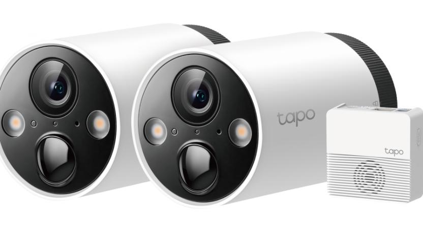
TP-Link's latest 2k security camera offers full-color night vision
TP-Link has launched the Tapo C40S2, an indoor/outdoor 2K night vision camera.
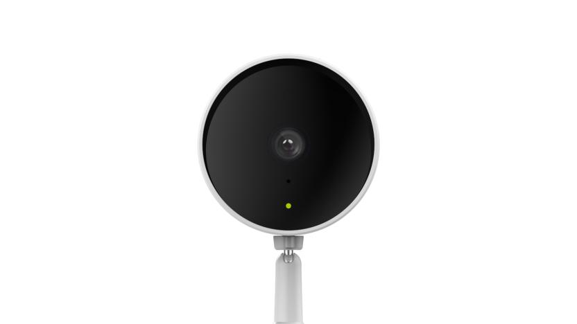
D-Link brings AI-powered person detection to its home security cameras
Ahead of CES, D-Link is bringing new features to its home security cameras. Today, the company announced that its devices can now detect people and breaking glass. The added capabilities are powered by AI that runs on the edge, and D-Link says it's able to provide faster, more accurate results than it would with cloud-powered AI.

Mitsubishi uses sound and WiFi to locate you indoors
There have been many attempts at locating you indoors when GPS fails, but they usually come with catches. WiFi alone isn't very accurate, for example, while a ton of beacons isn't always practical. Mitsubishi may have a good answer to those problems, however: using two techniques at once. It just developed an approach that determines your location based on the time it takes for sound to reach positioning-capable WiFi access points. It's accurate to within 3.3 feet, and it works with as few as three hotspots -- which, of course, can get you online at the same time as they get you from A to B.

Yahoo Maps adds indoor navigation powered by Nokia Here
Google Maps has offered indoor floor plans for quite some time, and now Yahoo is doing the same. Thanks to Nokia Here, Yahoo Maps now packs building layouts, directories and contact info for places like shopping malls, train stations and airports. This means you'll be able to locate restrooms and ATMs across multiple levels of football stadiums and other places in advance. The Finnish company introduced venue mapping back in 2012, and has since amassed info on over 75,000 venues. The Here integration should come as no surprise, though, as Yahoo and Nokia have been collaborating on cartography since 2010.

Google Maps 2.0 for iOS starts rolling out with iPad support, indoor maps (update: offline maps too)
The revamped Google Maps design reached Android last week; now, it's iOS' turn. Google Maps 2.0 is gradually rolling out worldwide for Apple's platform, and it's bringing the Android version's discovery and exploration components as well as some new-to-iOS features. Long-anticipated iPad support is the highlight, although there's also indoor navigation, live traffic updates and incident reports. Maps 2.0 hasn't hit the US just yet, although it should be available shortly. Update: It looks like it's hit the US App Store as of midnight ET or so, check the link below to grab the update yourself. If you're looking for offline maps, those are available with an Easter Egg like the one first featured in the Android version. Just zoom to the area you'd like to cache, then type "Ok maps" in the search box. [Thanks @carloslarez]

Google brings indoor Maps to Germany, says more Euro expansion to come
Not many would argue that Google's indeed quick to bring its latest and greatest software creations to many folks around the globe. More specifically, the Mountain View-based company announced today that its handy indoor Maps are now available in Germany, giving people there the ability to easily find their way around airports, shopping centers and even museums -- much like those in the UK and US have been able to do for some time now. According to Google, the indoor Maps availability in Germany solidifies its plan to "focus on our users in Europe," where the overall coverage "will be expanded and fast."

Google Maps Android API 2.0 lets developers tune apps for tablets, head indoors (video)
As aggressive as Google has been about pushing updates to Google Maps for Android, large swaths of those additions have been unavailable to third-party app developers. They're now on a more level playing field now that a version 2.0 Maps API is rolling out the door. The revamp is more accommodating of tablets and other big-screen gear through support for Android Fragments; many of Maps' more advanced information layers, such as indoor maps, are likewise exposed to those who don't work at a Google campus. The additions are already finding their way into apps from Trulia and a handful of others, but every other mobile developer with a cartographic bent can hit the source to upgrade their handiwork.

Google brings indoor maps to desktop web browsers
It may not be quite as practical as the mobile version if you find yourself lost in the mall this holiday season, but those looking to plan their shopping route ahead of time can now finally take advantage of Google's indoor maps in their desktop web browser. That new addition, just rolled out today, does come with a bit of a catch, though: the desktop version of indoor maps is only offering the main floor of buildings for the time being, with no word yet on when the ability to view additional levels will be added (something that can currently be done in the Android app). Of course, the availability of indoor maps is still quite a bit more limited than some of Google's other map offerings, but it does now include over 10,000 floor plans in a number of different countries.

Google Maps for Android takes navigation indoors for France, helps find your way through Carrefour
Interior navigation with Google Maps for Android has usually been the province of only a handful of regions at best. But what about Provence? While the deal isn't all-encompassing, Google is now serving indoor maps for popular locations throughout France. Coverage starts with the major airports in Paris and Lyon, extending to include major nationwide stores like Carrefour and FNAC, shopping centers like the Carrousel du Louvre and museums like La Géode. All told, over 50 venues have signed onboard and should be enough for those moments when you're rushing to catch a connecting flight at Orly... or just want to find the salad dressings in aisle three.

Nokia grows Destination Maps coverage to 4,605 venues in 38 countries, coming to Nokia Maps soon
After covering more than 23 million miles of the world's roadways, Nokia has focused on expanding its interior mapping footprint. Since its launch during CTIA 2011, the company's Destination Maps service has grown to cover a total of 4,605 different venues in 38 countries, including airports, department stores, shopping malls and transit hubs. As you can see in the infographic above, the majority of those locations are in North America, with a total of 2,595 mapped on the continent, followed by 1,778 in EMEA, 225 in the Asia Pacific region and just seven in Latin America -- that's 235 million square feet in all. Nokia also promises much more to come in the future, with hints identifying amusement parks and stadiums as possible beneficiaries. The company also reiterated its recent partnership with Bing, adding that Nokia Maps will have access to Destination Maps in the not-so-distant future as well. You'll find a few more details at the source link below, and while we don't have precise predictions to share, you can rest easy knowing that Nokia's indoor effort is far from complete.

Google Maps adds floor plans and walking directions for 20 US museums
Getting lost can be half the fun of any leisurely museum excursion, but if you'd prefer to navigate your indoor outing with a level of precision typically reserved for trips across town, you'll want to bring Google Maps along on your next journey to the Smithsonian. Mountain View just added 20 US museums to its battery of 10,000 indoor schematics, including the de Young Museum in San Francisco, the Philadelphia Museum of Art, Cincinnati Museum Center, the Indianapolis Museum of Art, the American Museum of Natural History, 17 Smithsonian museums and the National Zoo in DC. You can find the plans for any venue by searching or hitting the current location button once you're on site, and Google plans to continue growing its collection, with SFMOMA, The Phillips Collection, the Nelson-Atkins Museum of Art and the National WWII Museum in New Orleans set to join soon. Meanwhile, institutions interested in joining forces with Google can use the company's Floor Plans tool to get the process started. Full details are at the source link below.

IndoorAtlas uses disturbances in the (geomagnetic) force to map interiors, plot a path to aisle 3 (video)
Interior navigation is only just coming into its own, but IndoorAtlas has developed a technology that could make it just as natural as breathing -- or at least, firing up a smartphone's mapping software. Developed by a team at Finland's University of Oulu, the method relies on identifying the unique geomagnetic field of every location on Earth to get positioning through a mobile device. It's not just accurate, to less than 6.6 feet, but can work without help from wireless signals and at depths that would scare off mere mortal technologies: IndoorAtlas has already conducted tests in a mine 4,593 feet deep. Geomagnetic location-finding is already available through an Android API, with hints of more platforms in the future. It will still need some tender loving care from app developers before we're using our smartphones to navigate through the grocery store as well as IndoorAtlas does in a video after the break.

Google indoor maps comes to the UK, helps commuter meet pasty in record time
If you're forever getting lost looking for Barratts, or feeling faint hunting down a Greggs to fill your mall-explorer's belly, then Google Maps to the rescue. Mountain View's already made it clear it doesn't want walls to get between you and its mapping of the world, and now those hungry Android-using indoor Britons can get in on the action. There's only a hair over 40 venues covered right now -- a mix of museums, stations, malls and airports in the main -- and most of them in London. With building owners being able to upload their own maps, however, this should / could expand quickly. Good news either way, though if you can get lost at London Bridge Station, then no amount of maps will likely help.

Fujitsu, NICT create indoor navigation for the blind using ultrawideband, Android phones, kind hearts
There's no shortage of navigation outdoors, and even a little bit of help indoors, but there's been precious little aid for the blind indoors -- leaving them little choice but to move cautiously or get outside help. Fujitsu and Japan's NICT have crafted a system that gives the sightless a greater level of autonomy inside through ultrawideband-based impulse radio. A grid of UWB radios positioned around a room gauge the distances between each other and transmit the data to a PC, which then talks to the traveler's Android phone. The device then gives spoken directions based on a 12-o'clock system and far subtler distances than GPS can manage: the positioning is accurate to within a foot. While the indoors navigation is only just getting a demo this week, it's already being refined to detect objects in the room as well as to help even the fully sighted. If Fujitsu and NICT have their way, buildings ranging from hospitals to malls will have their own turn-by-turn navigation. For some, the freedom of movement could be a life-changer.

Google offers Floor Plan Marker app to businesses so they can improve indoor mapping
Are folks still getting lost in the faux marble expanse of your airport or shopping mall, even after you've uploaded the floor plan to Google Maps? Then maybe it's time you went the extra mile and improved indoor mapping using the official Floor Plan Marker app. It instructs you to walk around the "entire surface" of your place of interest, while gathering position data from GPS, public WiFi signals and cell towers. Once added to Google's database, this extra info will allow the familiar blue dot to function on your customers' Android phones even when your actually-concrete building gets in the way of their satellite signal. The app's already available at Google Play, so go ahead -- make the schlep now so that others don't have to.

Broadcom extends fiber reach with BroadLight acquisition, intros new location architecture
Here's a question: did Broadcom get a 50 percent discount for acquiring a company that already had "Broad" in the name? Hard to say at this point, but regardless of semantics, the aforesaid company has snapped up BroadLight in a bid to extend its fiber access portfolio. In lay terms, it's hoping to use BroadLight's inroads to roll out next-gen fiber networks across the globe -- perhaps even through the arctic. In semi-related news, Broadcom has also chosen today to reveal a new location architecture, which will reportedly provide "more responsive outdoor and indoor positioning capabilities for smartphone devices." The new system opens the door for even more indoor GPS locks, and it relies on a minty fresh Global Navigation Satellite System (GNSS) chip that "significantly reduces time-to-first-fix (TTFF) for outdoor positioning applications." The full deets on both can be found in the source link, but sadly there's no word on when the fancy new positioning tech will meander into your next handset.

Google Maps 6.0 hits Android, adds indoor navigation for retail and transit
Google's already put its stamp on the great outdoors, what with its Street View fleet chronicling the well-trodden ways of our world for Maps. Which is precisely why Mountain View's turning its attention inward for that next, great navigation innovation, as it attempts to chart a course through the wilds of indoor spaces. Hitting the Android Market in the U.S. and Japan today, the company's ever-popular app gets a full version bump to 6.0, bringing with it the inclusion of retail and airport floor plans. The newly added indoor maps don't quite offer the turn-by-turn navigation you've come to know and depend upon (that's outside-only for now), but the provided layouts should help usher you along to the nearest bathroom, clothing shop or elevator. There's no fancy equipment at use, either. All of your positioning information is culled from the same set of data (including GPS) used for "My Location," although here it's been optimized to detect movement along the z-axis. What does that mean for you, dear end user? Try a nifty feature called "Automatic Floor Detection" that'll keep track of your progress as you move about from escalator to escalator. Google's also endeavoring to extend its indoor reach, opening up its mapping inventory with a self-service tool (currently in beta) that'll allow business owners to upload floor plans directly to Maps. If you're itching to test the tech out, you'll want to find yourself at one of the dozen-plus airport partners scattered across the country, in addition to transit hubs and major retail outlets both stateside and in Japan. Familiar commercial forces like Macy's and Takashimaya have opted-in to the indoor location service, but your best bet's going to be IKEA -- which has agreed to roll the feature out to all of its stores nationwide. So, whether you're rocking Android 2.1 or the forward-facing 4.0, prepare to let your Googlefied smartphone almost always be your guide. Follow past the break for additional shots and a video demo of the indoor geo-location in action.

Bing Indoor Maps and Visual Voicemail shown in latest WP7 Mango demo videos
Steve Ballmer may have confessed during today's WPC keynote that Windows Phone 7's market share is still "very small," but it's obvious the team is doing monumental things with Mango. As the mobile OS finds it own, things like indoor mapping and a pristine iteration of Visual Voicemail could be key to swaying folks who still believe that Microsoft's latest attempt in the smartphone universe still lacks the basics. The fine folks over at Pocketnow and WMPowerUser have been putting the latest build of Mango through those exact paces, and both instances are looking downright delicious. We won't bore you with textual details; head on past the break for a bit of visual proof.

KDDI's Swing navigation system helps you find your way around a store, avoid human interaction
GPS can help you get to your favorite bookstore, but once you're there, it probably won't find that Thomas Pynchon book you're looking for. That's where KDDI's Swing navigation system comes in. Taking its cue from Nokia's Kamppi and NAVTEQ's Destination Maps services, the prototype is designed to help smartphone users find their way around malls, restaurants or any other indoor space, using only a red arrow as their compass. Just choose the section of the store you're looking for, wave your phone in a circle and KDDI's app will use a system of pre-installed sensors to find your location, before pointing you in the right direction. Seems intuitive enough, but Swing's success will ultimately depend upon how many people and retail outlets decide to adopt it. Swing past the break for a demo video.

NAVTEQ's Destination Maps provide mobile guidance through malls, outer reaches of your mind
For anyone that's ever been hopelessly turned around within the Mall of America (or the Las Vegas Convention Center), the promise provided by NAVTEQ's newly announced Destination Maps is quite compelling. It allows for orientation, guidance and routing for indoor venues like those mentioned above, and serves up a useful map of entrances, exits, restrooms, stairwells and points of interest that would otherwise be undetectable. Neither IDG News nor NAVTEQ mentions exactly how this is accomplished, but we can only speculate that a Hybrid GPS antenna is used along side a layer of augmented reality -- but then again, these could be static routes that require no positioning whatsoever to explore. It's also uncertain which mobile platforms would support such an app (despite having been demoed on a Nokia N8 in the photo above), or if this will even make it past the beta stage. More info is expected at Where 2.0 in April, and it's a pretty safe bet that Paul Blart will be on hand for its official debut.


