noaa
Latest
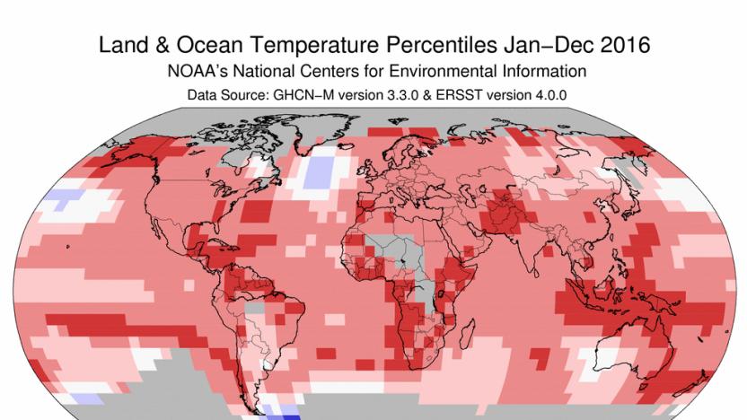
2016 was the hottest year on record (again)
According to a joint report from NASA and the National Oceanic and Atmospheric Administration, 2016 was officially the hottest year on record. If that statistic sounds familiar, it's because 2015 was also the hottest year on record. As was 2014 before that. And those three years of rising temperatures mean the planet is about two degrees Fahrenheit (1.1 degrees Celsius) warmer than it was in the late 19th century.

Watch the US launch a next-gen weather satellite at 5:10PM ET
If all goes according to plan, the US is about to enter a new era of weather tracking. The United Launch Alliance is scheduled to launch the first instance of GOES-R (Geostationary Operational Environmental Satellite), the US' next-generation weather observer, at 5:40PM Eastern (live NASA coverage starts at 5:10PM). The new satellite not only captures sharper images width more wavelengths, but takes those snapshots at a much higher frequency that promises to change how meteorologists and climatologists track environmental conditions.

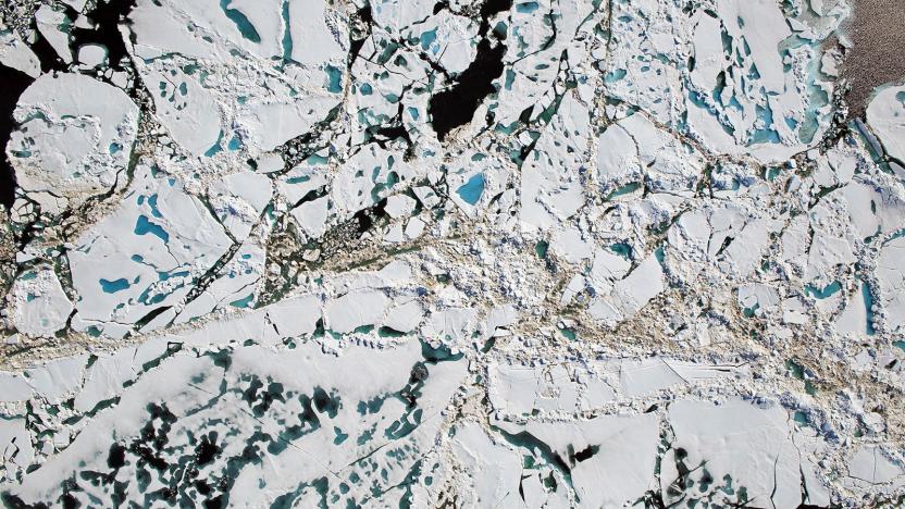
NOAA: US snow cover hits an 'all-time low' for November
Researchers just supplied more evidence that climate change-related temperature increases are having a material effect on the planet. America's National Oceanic and Atmospheric Administration reports that snow cover in the lower 48 states is the lowest ever recorded for mid-November. As you can see in the map below, there's very little snow on the ground in the country -- you'd likely have to climb a mountain to see it. For contrast, the average snow cover between 1981 and 2010 reached as far south as New Mexico.

White House initiative pushes for more tiny satellites
Miniature satellites are increasingly a big deal, and for good reasons: they're not only less expensive and easier to deploy than the giant satellites of old, but can cover wider areas. And the White House wants to give them a helping hand. It's launching an initiative that will foster small satellites with the resources they need to flourish. To start, NASA is not only proposing as much as $30 million toward purchasing data from these tiny vessels, but creating a Small Spacecraft Virtual Institute that will offer know-how to organizations. A more direct effort has the National Geospatial-Intelligence Agency awarding Planet a $20 million contract for a fleet of small satellites that can capture images of "at least" 85 percent of the planet every 15 days.

NOAA's solar storm forecasts now show the most affected areas
Solar storms are no joke -- they can knock out power grids and leave entire towns in the dark. Unfortunately, the forecast model the US National Oceanic and Atmospheric Administration (NOAA) uses only shows the current geomagnetic activity for the entire planet. It can give us a pretty good idea of when a solar storm will happen, but it can't tell us where it will hit the hardest. That's why NOAA has developed a better forecast model that can pinpoint which locations in the world will be affected the most. For instance, it can show if a storm's bound to have a bigger impact on a European country than on the US, so power companies there can take the necessary precautions.

ICYMI: Eye exams go DIY and smartfeeding your pets
try{document.getElementById("aol-cms-player-1").style.display="none";}catch(e){}Today on In Case You Missed It: A new device can calculate people's eyeglass prescriptions without needing to see an optometrist, though whether that's actually responsible or not is up to you. Meanwhile a cloud-connected smart petfeeder that suffered from downed servers had to send a notice to owners to feed their pets manually, since the machines lost all connection and didn't release food. There's a lot to talk about this week but we recommend reading up on NOAA's three month weather outlook, since everyone will be talking about the DNC this weekend anyway. As always, please share any interesting tech or science videos you find by using the #ICYMI hashtag on Twitter for @mskerryd.

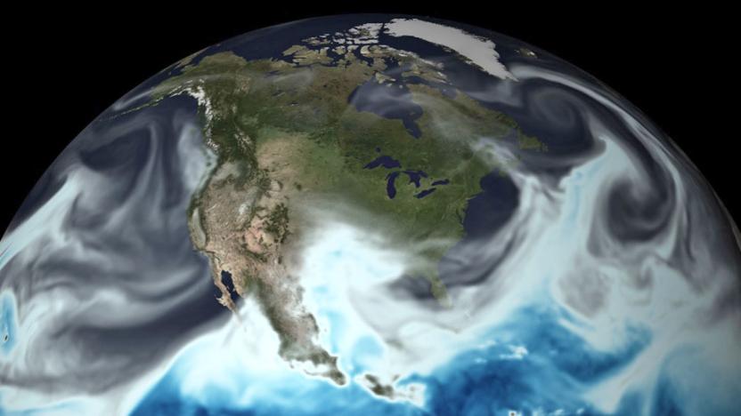
NASA releases a year-long look at the sunlit face of the Earth
The DSCOVR satellite gave us a rare glimpse of the sunlit face of the Earth in 2015. Now that it's been orbiting the planet for over a year, its EPIC camera has finally captured enough images for a year-long time-lapse video of our home. In the past, you had to be an astronaut to get a look at the side of the Earth that's lit up by the sun. DSCOVR changed that when it started orbiting the planet from a million miles away and taking photos of its view every two hours. The satellite is stationed between the sun and the Earth in a location that's known as the Lagrange point 1.
June marked 14 straight months of record high temperatures
Thanks to the ocean warming effects of El Niño and the global warming effects of humans in general, planet Earth just experienced its warmest June on record, the National Oceanic and Atmospheric Administration reports today. The extremely warm June marks 14 straight months of record-breaking warmth, and the longest hot streak on record.
NOAA's supercomputers can make hourly weather forecasts
NOAA's US Global Forecast System has gone 4D, thanks to the power of its new supercomputers. The agency has added "time" as a fourth dimension to its weather and climate model, allowing GFS to make hourly forecasts for up to five days out. Before the upgrade, GFS could only deliver forecasts for every three hours, which isn't exactly bad. But hourly forecasts allow first responders and disaster relief operators to plan their best course of action. Not to mention, people can use that kind of info in their daily lives, say to plan their commutes and avoid being on the road in the middle of a raging hurricane.

ICYMI: Drone net launcher, whale call science and more
#fivemin-widget-blogsmith-image-636237{display:none;} .cke_show_borders #fivemin-widget-blogsmith-image-636237, #postcontentcontainer #fivemin-widget-blogsmith-image-636237{width:570px;display:block;} try{document.getElementById("fivemin-widget-blogsmith-image-636237").style.display="none";}catch(e){} Today on In Case You Missed It: Hundreds of thousands of whale calls from a seafaring science journey in 2006 have finally been analyzed, resulting in proof that whales gather by species when feeding. Police officials are likely highly interested in the drone catching net, that launches from a large black metal tube that puts bazookas to shame, taking out drones up to 100 meters away. BMW's new concept car (the Vision Next 100) can subtly shift its shape near the wheels and of course has AI and augmented reality sensors for days. You can see a video of the newly discovered octopus species that doesn't yet have a name, read about Ray Tomlinson and learn more about the thing we can't not hate, the biēm butter sprayer (which of course, is on Kickstarter). As always, please share any interesting science or tech videos, anytime! Just tweet us with the #ICYMI hashtag to @mskerryd.

2015 was the hottest year on record
If you needed further signs that humans are likely warming the planet, you just got it. NASA and NOAA have independently determined that Earth surface temperatures in 2015 were the hottest since record-keeping began in 1880, beating the 2014 average (the previous record) by a sizeable 0.13 degrees Celsius. Most of the on-record warming happened within the past 35 years, too. And you can't pin this on weather patterns like El Niño. While those conditions certainly contributed to 2015's higher temperatures, it was the "cumulative effect" of decades of warming that led to the new high.

Watch SpaceX attempt a sea-based landing at 1:42PM ET
Flush with success from its first ground landing, SpaceX is about to make history again... well, maybe. The private space firm is scheduled to launch the ocean-monitoring Jason-3 satellite today (January 17th) at 1:42PM ET, and it hopes to once again attempt landing a Falcon 9 rocket on its drone barge. If everything goes ahead as planned, it'll be the first successful sea landing ever -- and SpaceX can put those unpleasant crashes behind it. You can watch the company's official stream below, while NASA TV has live coverage running before and during liftoff. Update: Unfortunately, the landing wasn't successful. [Image credit: SpaceX Photos, Flickr]

Xprize offers $7 million for exploring the ocean floor
After years of focusing on moonshots and other lofty goals, the Xprize Foundation now hopes to inspire innovation in the opposite direction... in a very literal sense. Its new Shell Ocean Discovery Xprize is offering a total of $7 million in awards to teams that can deliver robotic exploration of sea floors as deep as 4,000m (13,123ft). The $4 million grand prize and a $1 million runner-up prize will go to the groups that deliver the sharpest maps on top of meeting baseline requirements for autonomy, depth and speed. The top 10 teams will split a $1 million milestone prize, while the National Oceanic and Atmospheric Administration is chipping in another $1 million for teams that spot objects through biological and chemical clues.

Solar storm-monitoring satellite reaches orbit a million miles away
NOAA's Deep Space Climate Observatory (DSCOVR) almost become a very expensive piece of junk. It spent over a decade in storage until the Air Force injected the project with $35 million in much-needed funding. Now, the satellite has finally made it to its destination more than 100 days after SpaceX's Falcon 9 ferried it beyond our atmosphere during its first ever deep space flight. DSCOVR is now in its final orbit: a place called Lagrange point 1 (L1), located a million miles away from our planet or around four times farther than the moon. That position gives the satellite a clear view of both the sun and the Earth, allowing its instruments to effectively monitor solar winds, as well as measure ozone amounts and the planet's radiation budget.

Earth's ozone improves while CO2 levels worsen
Good news: the hole in the ozone layer is shrinking. Bad news: worldwide levels of atmospheric carbon dioxide has reached another terrifying milestone. First up, NASA's Goddard Space Center is promoting a scientific paper from December that claims that Earth's ozone layer is gently beginning to repair itself. With data from the agency's AURA satellite, scientists believe that the hole in the ozone, which currently measures 12 million square miles, will drop below that figure by around 2040.

US budget has NASA planning to capture an asteroid, USAF reviving DSCOVR (video)
Many have lamented the seeming decline of the US space program. While we're not expecting an immediate return to the halcyon days, the President's proposed federal budget for fiscal 2014 could see some renewed ambition. NASA's slice of the pie includes a plan that would improve detection of near-Earth asteroids, send a solar-powered robot ship (like the NASA concept above) to capture one of the space rocks and tow it back to a stable orbit near Earth, where researchers could study it up close. The agency would have humans setting foot on the asteroid by 2025, or even as soon as 2021. It's a grand goal to say the least, but we'd potentially learn more about solar propulsion and defenses against asteroid collisions. If NASA's plans mostly involve the future, the US Air Force budget is looking into the past. It's setting aside $35 million for a long-discussed resurrection of the Deep Space Climate Observatory satellite, also known as DSCOVR -- a vehicle that was scuppered in 2001 due to cost overruns, among other factors. Run by NOAA once aloft, the modernized satellite would focus on warning the Earth about incoming solar winds. That's just one of the satellite's original missions, but the November 2014 launch target is relatively realistic -- and we'll need it when the satellite currently fulfilling the role is overdue for a replacement.

iOS app warns mariners of whale proximity in real time
It's a whale of an app! WhaleALERT (free) provides a way to warn mariners in and around the Stellwagen Bank National Marine Sanctuary at the mouth of Massachusetts Bay of the proximity of North Atlantic right whales. The whales live and breed in the coastal waters between the Gulf of Maine and Florida, an area crisscrossed with busy shipping lanes. The purpose of the WhaleALERT app is to give mariners indications of seasonal- and dynamic-management areas and recommended routes to avoid collisions with the whales. As there are only an estimated 350 to 550 right whales in existence at this time and ship collisions are a leading cause of death, the app can help protect one of the world's largest rare animals. Although the app includes full coastal water charts for the entire Eastern seaboard of the US, the area encompassing the sanctuary is of particular interest as there are right whale listening buoys scattered hither and yon. Thanks to those buoys, the app can detect the location of right whales and generate a voluntary speed-reduction alert, hopefully reducing the number of ship/whale collisions. The screenshot below shows a live alert from today -- note that the time is listed in MDT as that is the time zone in which the screenshot was taken. The app may also be of interest to whale-watchers, particularly in the Massachusetts Bay area.

Google Maps and NASA invite you to peer into the Black Marble
If you've had your fill of that Black Marble animation from last week, how's about a more interactive jaunt around the globe? Google has now joined hands with NASA and NOAA to use stunning imagery of an illuminated, cloud-free Earth captured by the Suomi NPP satellite and put a map of the sleeping world right under your fingertips. The data was collected over 312 passes by the satellite using a new ultra high-sensitivity sensor dubbed the "day-night band of the Visible Infrared Imaging Radiometer Suite", and then mapped over existing "Blue Marble" pictures. If you think a nocturnal orbit around our home planet beats having a gander at faraway nebulas, but you can't quite afford a boarding pass, then a jump to the source link is most definitely in order.

Daily Update for February 9, 2012
It's the TUAW Daily Update, your source for Apple news in a convenient audio format. You'll get all the top Apple stories of the day in three to five minutes for a quick review of what's happening in the Apple world. You can listen to today's Apple stories by clicking the inline player (requires Flash) or the non-Flash link below. To subscribe to the podcast for daily listening through iTunes, click here. No Flash? Click here to listen.

NOAA drops BlackBerry, embraces iPhone and iPad
The Loop is reporting that the National Oceanic and Atmospheric Administration (NOAA) is taking RIM BlackBerry devices off of the list of officially supported mobile devices. What's taking the place of the trusty old BlackBerry? iPhones and iPads running iOS 5 and newer versions of the mobile OS. While a February 3rd memo from NOAA Chief Information Officer and Director for High Performance Computing and Communications Joseph Klimavicz noted that support for BlackBerrys will continue until May 12, 2012, it does not say when the government organization will actually start providing workers with the new Apple devices. According to the memo from Klimavicz, NOAA will now support employees with iPhone 4 and newer smartphones running iOS 5 or later, as well as iPad 2 or newer tablets running iOS 5 or later.


