SatelliteImagery
Latest
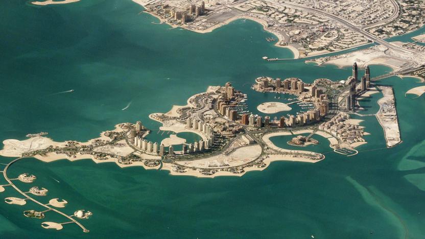
Side view satellite images turn the Earth into 'Sim City'
Satellite images can still enlighten and delight, but we're so spoiled by constant views from space that it's hard to surprise us. Satellite imaging company Planet has managed to do just that, however, with a collection of new images, including a shot of the man-made Pearl-Qatar island in Doha. Rather than shooting straight down, the satellites captured the images from oblique angles, creating orthographic-type views reminiscent of games like Sim City.

Satellite imagery can be used to predict regions of poverty
A new study in the journal Science shows how a combination of satellite imagery and machine learning algorithms can be used to predict poverty in regions of the world where data is otherwise unavailable. While it has long been accepted that nighttime lighting is a rough indicator of a region's wealth, that method of analysis is ineffective when dealing with regions of the world where there is often no power at all. This new method, described by lead author Neal Jean, actually uses nighttime images as well as publicly available daytime imagery and survey data to teach a computer system to estimate just how rich or poor an area is.

Google brings higher-resolution imagery to Earth and Maps
Every few months or so, Google improves the satellite imagery on services like Earth and Maps. Now, as part of its efforts to keep making the experience better for users, the search giant is going to offer higher-resolution virtual views going forward. You'll now notice sharper imagery of areas around the world, thanks to the latest data from the Landsat 8 satellite and "new processing techniques" that Google's implementing.

Bayer to use satellite imaging to modernize farming efforts
You probably know Bayer for its aspirin. But the multinational pharmaceutical company has its fingers in more pies that that -- it's also keen to become a force in agriculture. As part of a push to focus on its Crop Science division, the company's partnered with Planetary Resources, an aerospace tech company, to create products and services using data obtained from satellite imagery. The goal? To sell services and tools to farmers that will make agriculture more efficient and environmentally adaptable. Though the collaboration has just been announced and, therefore, no services have yet been created, Bayer's indicated a few key areas where satellite data could be beneficial: water conservation through more ideally timed irrigation; recommendations on timing for crop planting; and the ability to determine what soil will hold water best.

Google Earth gets two new features for its 10th birthday
Can you believe that Google Earth has been around for a full decade now? To celebrate this milestone, Google unveiled a pair of striking new (and expanded) features to the planet virtualization system on Monday. The first is Voyager, which available on the desktop edition. It's designed to help you pick out and explore the coolest and newest imagery from around the world. These are organized into five categories: Street View, Earth View, 3D cities, Satellite imagery updates, and Highlight tour.

The Big Picture: The frozen US as seen from space
Wondering why February has been so mind-numbingly cold? Here's why. NASA's Terra research satellite took a snapshot on February 19th showing that much of the US has been draped in Arctic and Siberian air masses, painting the country white with snow. Even southern cities like Macon, Georgia dipped well below freezing, according to weather reports. While those conditions are (thankfully) going away, they made for a spectacular view from space -- not that you'll likely want to see it again.

Google is giving non-profits its latest satellite maps
Non-profit groups don't often have the luxury of using satellite maps to gauge their progress clearing landmines or saving trees. Getting fresh imagery is typically expensive, if it's an option at all. Google's recent acquisition Skybox wants to fix that with Skybox for Good, a new program that gives non-profits up-to-date satellite photos to help track their work. It's just in beta testing at this point, but a handful of partners are already using the data to see how they're boosting education, protecting the environment and repopulating previously mine-laden areas. The icing on the cake? You can see these maps yourself -- Google and Skybox are publishing all the images on Google Maps under a sharing-friendly Creative Commons license, so you'll know exactly how these noble causes are faring.

The Big Picture: Satellite imagery details ocean depths with new maps
Harnessing data from two satellites, scientists at Scripps Institution of Oceanography at UC San Diego have built a new map of the deepest parts of the ocean. Combining info from the European Space Agency's (ESA) CryoSat-2 and gravity readings from NASA's Jason-1 with existing research, the team is able to show details that include undersea mountains and "little-studied remote ocean basins." The project's report explains that "one of the most important uses of this new marine gravity field will be to improve the estimates of seafloor depth in the 80 percent of the oceans that remains uncharted or is buried beneath thick sediment." Still curious? Peruse more the findings here.

The Big Picture: Infrared satellite images reveal the true extent of a forest fire
DigitalGlobe's recently launched high-res imaging satellite isn't just in orbit for the sake of creating pretty pictures; it can also uncover things that you might never see at all. As proof, the company has posted before-and-after imagery of a California forest fire that shows off the advantages of WorldView-3's shortwave infrared sensor, which can easily see past clouds and smoke. Suffice it to say that the sensor's effect is dramatic -- areas that would have been completely obscured are suddenly in plain sight, revealing both the perimeter of the blaze and its intensity. The hope is that firefighters will use overhead shots like these to pinpoint areas where they're needed most, saving people and whole regions. It could be a while before emergency teams are pulling up satellite views at a moment's notice, but it won't be surprising if aircraft-based fire recon eventually becomes obsolete.

First satellite with high-resolution public imaging launches on August 13th
If you've been wondering just when a company would take advantage of the US' relaxed rules for accurate satellite imaging, you now have a date to mark on your calendar: Lockheed Martin has set the launch of DigitalGlobe's high-resolution WorldView-3 satellite for August 13th. You won't see results from it right away, but its creators can start selling extra-sharp pictures (with detail down to the 10-inch level) six months after the craft is up and running. The data should lead to much nicer imagery in online mapping services from companies like Google and Microsoft (both of which are DigitalGlobe customers), although it's not just cosmetic. Higher-res photos will help track large farms, spot mineral deposits and otherwise deliver a clearer view of our planet that has previously been limited to the government -- don't be surprised if it's easier to spot landmarks on a map without using markers.

Bing Maps revamped with ocean topography, updated satellite imagery
Ballmer and Co. have loaded up Bing Maps with yet another batch of images, and though they're staying quiet about the update's file size this time, they say it includes 13,799,276 square kilometers of fresh high-res satellite shots and a better view of the ocean floor. Brand-new "straight down" photos give the base map a resolution of 15 meters per pixel, and the introduction of bathymetric imagery changes the ocean's hue depending on its depth. The refresh even contains fewer clouds, giving users a less obstructed view of Earth. Thanks to additional aerial photos covering 203,271 square kilometers, Microsoft's map service now covers the entirety of the US and 90 percent of Western Europe with pictures taken from aircraft. Armchair cartographers ready to explore the world remotely can find the revamped visuals already baked into Bing Maps online and within the service's Windows 8 app.

Google Maps creation put under the microscope, reveals a human touch
They say you should never learn how the sausage gets made, but we're willing to make an exception for Google Maps. Talking to The Atlantic, Google has revealed just how much the human element figures into all that collected satellite imagery and road data. Many pieces of terrain information are tested and modified against what Google calls Ground Truth: actual driving, alternate sources and sign photos automatically extracted from Street View runs. Google isn't just making the occasional correction, either. Mapping a country can take hundreds of staff plugging away at the company's Atlas tool, even before we get a crack with Google Map Maker. The combination of man and machine helps explain why Google Maps is one of the most accurate sources of location information on Earth -- although the firm does have some catching up to do in space.

Amateur archaeologist finds possible pyramids using Google Earth
While most Google Earth hobbyists are satisfied with a bit of snapping and geotagging, some have far loftier ambitions. Satellite archaeologist Angela Micol thinks she's discovered the locations of some of Egypt's lost pyramids, buried for centuries under the earth, including a three-in-a-line arrangement similar to those on the Giza Plateau. Egyptologists have already confirmed that the secret locations are undiscovered, so now it's down to scientists in the field to determine if it's worth calling the diggers in.

Google Earth, Maps get new high-res aerial and satellite imagery
3D City View for iOS isn't the only update from the Google Maps and Earth team this week, they've also spruced up their services with new imagery. Fresh high-resolution aerial and satellite photos have been added for a roster of 25 cities and 72 countries or regions, ranging from Antelope Wells, New Mexico to Zimbabwe. In addition, seven international locales and 21 US cities received the 45-degree view treatment, letting you gaze at skylines from a different perspective. The maps are already available, so you can peruse new satellite images of London's Olympic Park and Village just in time for the festivities. For the full list of areas with crisper cartographic visuals, check out the source below.

Google fetes 40 years of Landsat with new timelapse videos of Earth
Compared to Landsat, which has been beaming photos of our planet since 1972, Mountain View is a cartographic newb. But Google Earth drove geospatial interest into the stratosphere when it launched in 2005 and, with a billion downloads and counting, the company is well placed to celebrate 40 years of Landsat imagery. To do that, it has collaborated with the US Geological Survey and Carnegie Mellon to create a collection of timelapse videos ranging from seasonal snowcover changes across North America to Amazon deforestation. Though the search giant is gradually shifting from relatively low-res 100 feet per pixel Landsat imagery to 8 feet SPOTImage maps, its Google Earth Engine was used to process the vast archive and make it available to the public. To watch a video of the history of the grand dame of satellite imagery and its liaison with Google, head after the break -- or check the source for all the timelapse goodness.

Bing Maps gets another 165TB of satellite images, Google Earth seen sulking in a corner
Thought that Google had cornered the market on free, overhead-view photo mapping solutions? You clearly don't reside in Redmond, because Bing Maps' aerial image library just got another 165TB worth of hi-res data that covers an additional 38 million square kilometers of the globe. To put that in perspective, Microsoft's mapping solution previously had but 129TB worth of such eye-in-the-sky imagery, so this new batch of satellite shots more than doubles your viewing pleasure. Go ahead, check out all the new visuals at the source link below, we promise not to tell the folks in Mountain View.

NASA shows first global image taken from new satellite; Captain Planet approves
From breaking the ice on Jupiter's moon Europa to going Captain Ahab on comets, NASA's been quite busy formulating all sorts of "strategery" for future projects lately. But just because the space agency has to pay Russians to hitch a ride to space these days doesn't mean it has nothing going on in the present. Check out the first image from NASA's NPOESS Preparatory Project (NPP) satellite. The satellite launched October 28th and, eventually, will be able to measure anything from ocean temps to fire locations. While it can't do all of that just yet, the NPP satellite is at least capable of taking global images with its Visible Infrared Imager Radiometer Suite (VIIRS). The satellite is placed in a sun-synchronous orbit that lets it sync with the areas it covers at roughly the same time of day. The result? All images will have the same lighting since the satellite maintains the same angle between the Earth and the sun.

Garmin's Astro 320 GPS handheld offers nine-mile coverage, keeps your hunting dogs in line
Before you and your pooches head out to hunt innocent ducks this year, you might wanna check out Garmin's new Astro 320 dog tracker -- a handheld GPS device designed to help hunters keep even closer tabs on their four-legged sentries. The latest addition to the Astro family can simultaneously track up to ten hunting dogs per receiver, with a revamped antenna and three-axis electronic compass covering up to nine miles of flat terrain. Boasting a 20-hour battery life, the 1.7GB handheld can also tell hunters whether their canines are running or pointing, while its mapping capabilities provide their precise coordinates relative to powerlines, buildings, and individual trees. All this information is displayed on a 2.6-inch display, where users will be able to access 100k or 24k topographic and satellite maps. A keypad lock function, meanwhile, will make sure you don't accidentally press any buttons while you're in the thick of a hound-led hunt. The handheld will be available in July for $500, with the full system (including a DC 40 tracking collar) priced at $650. You can flip through the gallery below for images of some antenna-toting doggies, or head past the break for a more testosterone-laced pic and the full PR. %Gallery-125121%

Cheating cheaters using smartphones and GPS to make mazes less fun
When you enter a maze you are looking to do one of two things: get lost and have fun finding your way out, or save yourself from an axe-wielding maniac whose manuscript isn't quite coming together as he'd hoped. Unless you're going for option number two we'd have to say anyone who cheats to escape the maze is rather missing the point. That includes a growing number of visitors to Britain's giant yew maze at Longleat house in Wiltshire, a beautiful structure with seven foot tall walls that, on average, takes a person about an hour and a half to get through. However, lately it's been taking as little as 10 minutes as short attention spanned visitors get bored, whip out their smartphones, and load up whatever satellite imagery app is at their disposal. Effective? Yes. Defeating the purpose? Obviously.

Hands-on with the Blusens G01 satellite imagery GPS
We were pretty stoked about the Blusens G-series PMPs that overlay guidance information on Google Maps satellite imagery when we first heard about them in October, and now Spanish site Xataka has a hands-on video with the G01, which appears to be just as impressive as we'd hoped. The satellite maps automatically appear when available for the area you're in, and Xataka says the unit itself is quite fast. Sadly, there isn't a ton more detail in the review, but those of you aching for some shaky camera work and cheesy country-rock tunes can check out the vid after the break.


