compass
Latest
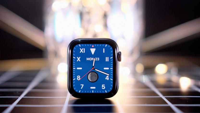
Save $50 on the latest Apple Watch at Best Buy
The latest Apple Watch, the Series 5, is on sale at Best Buy today. Apple debuted the Series 5 in September, and we gave it a score of 88. At first glance, it looks nearly identical to the Series 4, but it has a couple features the previous Apple Watch models didn’t, including an always-on display, built-in compass and international emergency calling.

Jeep preps plug-in hybrid versions of its Compass and Renegade SUVs
Jeep isn't exactly synonymous with eco-friendly cars, but it's bent on changing that reputation. The 4x4 maker has unveiled plug-in hybrid versions of the 2020 Compass (below) and Renegade (above) crossover SUVs. Both meld a 1.3-liter conventional turbo engine with an electric motor to deliver both more power and, of course, a lower environmental footprint. They can pump out up to 240HP when both powerplants are engaged, hitting 62MPH in about 7 seconds, but they can also drive for up to 31 miles solely on electric power. You could commute emissions-free in the city while still having plenty of range and raw grunt for your off-road excursions.

Quantum 'compass' promises navigation without using GPS
GPS is vital to modern navigation, but it's extremely fragile. Never mind coverage -- if a satellite fails or there's a jamming attack, it quickly becomes useless. Scientists may have a much more robust answer, though. Scientists have demonstrated a "commercially viable" quantum accelerometer that could provide navigation without GPS or other satellite technology. The device uses lasers to cool atoms to extremely low temperatures, and then measures the quantum wave properties of those atoms as they respond to acceleration.

Android malware found inside seemingly innocent QR code apps
Google is getting better at keeping Android malware out of the Play Store, and that's leading attackers to use more sophisticated disguises for their rogue apps. SophosLabs has proof: it just detailed a recent ad-spawning malware strain, Andr/HiddnAd-AJ, that slipped into Google Play through innocent-looking QR code and compass apps. While that's nothing new by itself, the malware used a pair of tricks to feign innocence. The hostile code was buried in what looked like a regular Android programming library, and it didn't kick in until 6 hours after you've installed it.

Laptop pioneer John Ellenby dies
The PC industry has lost one of its quieter but more influential leaders: John Ellenby, the CEO of Grid Systems, died earlier this month at the age of 75 of yet to be determined causes. His company (particularly late designer William Moggridge) is widely credited with making the first commercially successful clamshell laptop, the Compass. The 1982-era machine was thick, had a tiny screen and was wildly expensive for the time at $8,150. However, it was a hit among companies and governments -- it was a relatively slick way of bringing computing (and even basic digital communication) with you at a time when the alternatives were barely-luggable desktops like the Kaypro or Osborne 1.
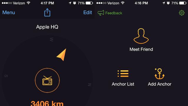
Anchor Pointer is a great app for finding your car or that great fishing spot
One of the downsides of using geolocation pins with standard GPS apps is that they're designed with driving and roads in mind. For those of us who walk more than we drive, these routes aren't always ideal. After all, your feet aren't confined to streets and the fastest route between two points is still a straight line. That's why I've enjoyed using Anchor Pointer as my go-to navigation tool when I'm trying to find my way back to locations I've discovered while walking around or when I'm trying to find where I parked my car. Anchor Pointer gives you a compass that directs you to locations you've already been to. It's designed for saving locations rather than finding them via discovery, which makes it ideal for hikers and urban explorers, or just to find your car at the mall. The way it works is simple: when you find a location you want to save you, tap "Add Anchor" to save the location. You can add an icon and a name to represent the location. If you're just looking to save the location of your car in a parking lot, that functionality is listed on the main app screen as "Park Car." Once you select a location, Anchor Pointer provides a compass that directs you back to where you once where. It doesn't matter if you've never used a compass before -- simply follow the arrow and you'll find your way back. The parking feature has proven indispensable when looking for my vehicle in parts of town I might not already be familiar with and in large mall parking lots. However, the real charm of Anchor Pointer ls as a way to rediscover places you've been to once and want to revisit. Find a cool coffee shop while walking around your neighborhood? Drop an anchor. Discover a mural on the side of the road you want to remember? Drop an anchor. Maybe you're a fisherman and you've found an ideal spot where they're always biting. No problem, you can even drop an anchor over water and have the compass navigate you back to that spot. Anchor Pointer also has a "Meet Friend" feature allowing friends to share their location with you. I haven't been able to use this feature yet as no friends of mine use the app, but given how well everything else works, the tool could be very useful for meeting up with friends in the park or at a concert. I could see this feature being very attractive for parents trying to meet up with their kids at a crowded location. Anchor Pointer includes a handy automatic Night Mode that adjusts the brightness of the app based on the time of day, making it ideal for using at night in the woods without suddenly being blinded by your phone. You can also turn off the auto brightness function if you wish. Whether you're an adventurer looking to find your way back to your discoveries or just someone who is sick of losing your car in mall parking lots, Anchor Pointer is a delightfully useful app. My only complaint is that you currently can't drop an anchor unless you're physically at a location. It would be nice to use the handy compass feature to find my way to a place I know the address or coordinates of, even if I haven't already been there. Hopefully that shortcoming will be fixed in a future update. Even without that ability, Anchor Point is a handy tool for adventures and travelers. Currently the app is only $1.99 in the iTunes Store. That's a small price to pay for such a useful exploration tool.

Researchers deliver encoded messages and data through your smartphone compass
NFC, Bluetooth, WiFi, mobile data, plain 'ole voice calls. Your phone has no shortage of ways to connect with things, but that hasn't stopped a group of Finnish scientists finding a way to communicate through your smartphone's built-in compass. Just because they could. While NFC can send data up to 20 centimeters away, these magnetic messages diffuse within a few centimeters -- this limitation could help make wireless payments more secure. Researcher Kostakos Vassilis, talking to New Scientist , said that this magnetic messaging system would mean the phone exchanges nothing until it is within two centimeters (roughly 0.8 inches) of the payment terminal. When the devices get close enough, a secure code could then be delivered through a magnetic field, activating a wireless payment app or NFC connection. Through the data encoded through a varying magnetic field, the team at the University of Oulu in Finland were able to deliver web addresses (and even an anachronistic MIDI music file) from an electromagnet to the phone. At 40 bits per second, heavy data lifting isn't going to happen here, but the group says it'll outline more uses later this summer. We're hoping it'll involve Wooly Willy.

Spyglass beefs up iOS navigation with augmented reality for the great outdoors
Sure, you can use the regular maps available for iOS to get around, but those who trek around the wilderness need a bit more muscle. Well, Spyglass offers just that, employing all of the sensors Apple's devices house and tossing in a bit of augmented reality for good measure. The app overlays compass, GPS and location info on top of visuals captured by an iPhone camera or the map itself. There's also a load of more advanced navigation tools for in-depth tracking -- options that include a high-tech viewfinder (HUD), MIL-SPEC compass, gyrocompass, tactical GPS, speedometer, altimeter, rangefinder, sextant and more. Real-time tracking based on the location of stars, the sun and the moon is possible too, as is the ability to save waypoints for the return trip. You can also save specific spots for later, snap pictures with the data overlaid and employ one of a dozen different coordinate systems ranging from civilian to military. Sound too good to pass up for that next mountain excursion? Spyglass is available now via the iTunes App Store for $3.99.

How to use the iOS Compass for basic land navigation
iOS ships with a basic compass that you can use to find your basic heading when driving or hiking. It's not as robust as some third-party orienteering apps, but it will work in a pinch when these other apps are not available. When you launch the compass, you may be required to calibrate it by tilting your iPhone until you fill in a circle. This tilting circle is new to iOS 7 and differs from the figure 8 calibration in iOS 6 and earlier versions. Once calibration is done, the compass will show you magnetic north by default, but you can switch to true north by going to Settings > Compass and turning on the toggle for "True North". That long, bold white line is your compass needle and shows you the current direction that you are facing in degrees and direction (77°E, for example). As an added bonus, the compass uses location services and will pull down your city, state and exact GPS coordinates. The four major directions (N,S,E,W) are clearly labeled on the compass face. If you want to find north, hold your phone level in your hand and slowly turn yourself until your white compass needle matches up with N and its red arrow. You can do the same with all the major directions by turning with your phone in your hand until the compass needle aligns with your intended direction. If you know the direction that you need to walk (15°N, for example), you can lineup the compass needle to that heading and then tap on the compass face to lock it. The heading will be bolded and highlighted with a short white line on the compass face. As you walk around, the compass will track your direction and will draw a red arc on the inside of the compass dial that shows you how far you are deviating from your intended target. When you are done, just tap on the compass face and your heading point will be removed. The compass app does not include standard compass features like orienteering lines and a direction of travel arrow for use with a map, but the compass does link to Apple Maps and you can use that in a pinch to navigate. Just tap on the GPS coordinates in the Compass app to launch Maps. You then can tap the navigation icon in the bottom left until you turn on compass mode, which will orient the map with magnetic north. Once you know where north is on the map, you can find your target on the map and guesstimate your direction of travel. This is only a tool that should be used as last resort or for fun. As Apple points out, "the accuracy of the compass can be affected by magnetic or environmental interference; even the magnets in the iPhone earbuds can cause a deviation. Use the digital compass only for basic navigation assistance. Don't rely on it to determine precise location, proximity, distance, or direction."

The Inteliscope connects your iPhone to an actual firearm
We've talked before about how the iPhone can do a lot of things for you, but can it serve as a scope on a tactical rifle? That's the idea behind the Inteliscope, a new accessory that connects your iPhone to an actual tactical firearm. You just clip your iPhone 5 (or 4S or iPod touch) to the accessory, connect that to your rifle and you've got a heads-up scope that allows for custom crosshairs, video recording, a built-in compass and GPS, a timer and a few more handy functions. The idea is pretty ingenious -- it seems like using the iPhone's camera would offset the view, but maybe the accessory actually uses mirror to line up your shot. At any rate, the Inteliscope and its associated app will be available in June of this year, with each model costing US$69.99. You can pre-order the attachment right now.

Sony preps extra-low power mobile GPS chips, draws on motion sensors for help
Many of us can vouch for smartphone navigation being something of a battery hog. Sony would like us to navigate relatively guilt-free: its D5600 and flash-equipped D5601 chips chew no more than 10mW of power for everything they do. Most of their peers demand more than that just for the RF side of the equation, Sony says. They also won't lean on outside help for their location fix. Both chips talk to GPS, GLONASS and similar systems, but they further share the increasingly common ability to use an accelerometer, gyroscope and magnetometer to get a more reliable position lock. Don't expect thrifty GPS just yet, when Sony ships the basic D5600 in June and D5601 in September; that doesn't even include the time spent to build a phone or tablet around either of the new parts. We'll be patient if they reduce that anxiety over battery life whenever we're getting directions.

Google Maps offline for Android is available today in version 6.9, also Compass Mode for Street View
Google showed off offline Google Maps at its event earlier this month, and now during I/O it's ready to turn the feature on. We've got a couple of video trailers for offline Google Maps here (embedded after the break), users with Android 2.2 devices and above should keep an eye on Google Play for the new version of the app. Also new in this version is the Compass Mode for Street View shown off today, that lets you look around places as though you were there based on your device's gyroscope and even go inside. We're not all seeing it on our devices yet, but the updated version has already been spotted on a Galaxy Nexus or two.

FishPi sets course for the open sea, captained by a Raspberry Pi
Raspberry Pi's journey to reach owners has been a lengthy one, but Greg Holloway is preparing to send his board on a longer voyage -- one across the Atlantic. Nestled inside a tupperware tub, the RaspberryPi is the brains of FishPi, an autonomous vessel -- guided by GPS and a compass -- that measures 20 inches from bow to stern. Currently in proof-of-concept form, the craft uses a 40 mm rotating propeller and draws juice from batteries powered by a 130 watt solar panel. Producing kits for students, enthusiasts and professionals is the goal of the project, but testing and development are still on the docket. While the Linux-laden launch isn't ready for the high seas quite yet, you can sail to the source for the technical breakdown or check it out at the Nottingham Hackspace Raspberry Jam next month.

Opening the Book(Book) on Twelve South: between the covers of a Mac-exclusive accessory maker
The year is 2009. In history books, it'll widely be recognized as the year that most of America -- heck, the world -- would prefer to forget. Job after job was lost, bank after bank fell, and humanity as we knew it plunged into "the worst recession since the Great Depression." It's also the year that Palm attempted a comeback with webOS, and as it turns out, the year that yet another accessory company was born. While such an occurrence may be forgettable on a macro scale, economic researchers and lovers of technology alike have reason to take notice -- and, indeed, ask questions. So, that's exactly what I did. Beyond growing a technology startup in a me-too field during the worst economy that I've personally been a part of, it's also not often that I find compelling consumer electronics companies far outside of New York City and San Francisco. Twelve South just so happens to be located in a nondescript nook in Mt. Pleasant, South Carolina -- just a beautiful trip over the Arthur Ravenel Jr. Bridge from historic Charleston. Three years after its founding, the company now fittingly counts a dozen employees on its roster, and despite entering a market flooded with iAccessory after iAccessory, it has somehow managed to grab its own slice of an increasingly large niche. As with all good success stories, this particular outfit has plenty of twists, turns and run-ins with Lady Luck to tell about; for those interested in seeing how the "stay small" mantra is keeping Twelve South firmly focused on the future ahead, take a peek beyond the break.

ArenaNet blog update details changes to Guild Wars 2's boons and conditions
ArenaNet has just released a new blog post to follow up its first Guild Wars 2 press beta weekend. Lead designer Eric Flannum says that the preview event went off without a hitch, and he also indicates that the dev team has a lot on its plate as it gears up to bring the game to a wider audience. He starts things off with a look at Guild Wars 2's unique "downed" mode, which is basically a pre-death state wherein you have a limited selection of abilities to rally and potentially save yourself. The blog goes on to detail changes to the game's compass, tweaks to its meta-events, and an extensive look at the updates to boons and conditions. Head to the official ArenaNet website for all the details.

Belfry brings Stocks and Weather, other native iPhone apps to jailbroken iPads
Rounding out the honeymoon period with that freshly jailbroken iPad 2? Well now we have some new apps for you to play with, and you may already be acquainted. iOS hacker Ryan Petrich's most recent project, dubbed Belfry, lets you install stock iPhone apps that are otherwise absent from both versions of Apple's tablet including Clock, Voice Memos, Stocks, Calculator, Compass and Weather. As to why these aren't included already is beyond our knowledge, but at least there's an alternative. Users can install Belfry directly within Cydia for free from the BigBoss repository. If you're looking for proof to seal the deal, you can catch the bashful Belfry and his silent film antics after the break.

CSR sharpens indoor and in-car navigation with SiRFstarV, SiRFusion and SiRFprimaII
It's been a while since we last heard from CSR, but that changed earlier this week, when the company unveiled its new SiRFprimaII and SiRFusion platforms, alongside its SiRFstarV architecture. According to the UK-based firm, both SiRFstarV and SiRFusion are designed to provide more accurate geographic data and enhanced indoor navigation capabilities across PNDs and other mobile devices. SiRFstarV, the logical follow-up to CSR's SiRFstarIV architecture, culls location data not only from GPS, but from Galileo, Glonass and Compass satellites, as well as a range of radio signals, accelerometers, gyros and compasses. All this information is fed to the user via the SiRFusion platform, which combines data from radio systems and sensors to provide constantly updated location graphics. Together, both SiRFstarV and SiRFusion promise to help users find their way around both indoor and outdoor locales, within an accuracy range of ten to 15 meters. The SiRFprimaII platform, displayed above, is strictly geared toward in-car navigation and infotainment systems. This system combines a SiRFprimaII SoC and TriG RF multi-GNSS radio with CSR's Bluetooth and WiFi technologies to create a multimedia rich, touchscreen-based in-car environment. Geared toward both ODMs and OEMs, this hardware-software combo enables drivers to get more reliable navigation data, while allowing passengers to stream video, surf the web and manipulate everything via remote control. As for that SoC, it's powered by a 1GHz ARM Cortex A9 app processor, features an LCD controller for displays of up to 1280 x 720 resolution, and boasts a pair of 3D graphics and video accelerators. For more details, check out the pair of press releases, after the break.

Patent suggests augmented reality coming to Maps and Compass apps
According to Patently Apple, a new patent application from Apple suggests the company is interested in baking augmented reality functions into the iPhone's built-in Maps and Compass apps. In one implementation suggested by the patent, users could take a picture of their surroundings and perform a navigational search based on the image, including turn-by-turn directions. Apple's augmented reality function would overlay information on the iPhone screen's image, giving users data on objects they're currently viewing such as streets, buildings, and so forth. Building from there, the patent essentially describes a GPS navigator that feeds off input from the camera and overlays information in real-time. Many third party apps have come out utilizing augmented reality functions in one form or another, but what the patent describes sounds like some pretty futuristic stuff. Standalone GPS devices and even the Maps app on the iPhone do a decent job of giving directions, but there's still an abstraction layer between the user and the real environment with these interfaces. This new augmented reality navigator would go a long way toward paring away the more abstract portions of navigation. The standard patent caveat applies: since this is only a patent application, there's no guarantee this will ever actually debut on one of Apple's devices. However, given the functions described and the already powerful capabilities of the iPhone's hardware and OS, I don't see any reason why this function wouldn't eventually find its way to market. Maybe it's something to look forward to in iOS 6 next year.

Microsoft licenses GeoVector's augmented reality search for local guidance (video)
After the ho-hum AR demonstration of Windows Phone Mango, Microsoft appears to be stepping up its game by licensing a mature set of technologies from GeoVector, (a company previously known for its defunct World Surfer application). While the details remain elusive, Ballmer's crew was granted a multi-year, non-exclusive right to use and abuse the pointing-based local search and augmented reality elements of GeoVector's portfolio -- surely capable of bringing Local Scout to the next level. While much of the technology relies on GPS and a compass for directional-based discovery, the licensor also holds intellectual property for object recognition (à la Google Goggles), although it's unclear whether this element falls within the agreement. Of course, Microsoft could have turned to Nokia's Live View AR for many of the same tools, but that would have been far too obvious. Just beyond the break, you'll find the full PR along with an (admittedly dated) video of GeoVector's technology.

Bushnell BackTrack D-Tour personal GPS takes you home, shows you how it got you there
We've seen our fair share of uncomplicated (and under-featured) GPS units, but the Bushnell BackTrack D-Tour throws in just enough tricks to make our inner techno-mountain-man salivate. The D-Tour does away with onboard maps and turn-by-turn directions for five simple waypoints and a digital compass. Lose your way? Just follow the arrow back to the campsite. When you get home, you can dump your hiking data into Bushnell's map application, which will show you exactly where you've been, how far you traveled, and how fast you trekked. Its also a built in digital compass, clock, thermometer, and altimeter. Not too shabby, but a bit steep at $120, considering you'll still need to provide your own maps. Hit the break for a video of the doodad's track recording and mapping software.


