geospatial
Latest

US limits AI exports over fears it will fall into Chinese hands
The US government's concerns about Chinese involvement in tech are leading to significant restrictions on AI. The Commerce Department is instituting a rule on January 6th that will require companies to obtain a license if they want to export certain AI-powered geospatial imagery software to other countries besides Canada. Not surprisingly, officials are worried that the technology (which helps drones and satellites identify objects) might fall into the hands of China and other political challengers.

DJI throttles its drones unless you register them (updated)
You might not have to register your drones through the Federal Aviation Administration anymore, but if your flyer of choice is a DJI model, you'll have to activate it online, or take a hit in flight range and functionality. The company is adding a new application activation process, tied to a firmware update for its family of drones. It'll come into effect at the end of this week, and is aimed at ensuring pilots use "the correct set of geospatial information and flight functions for your aircraft", determined by your location and user profile. The aim should be fewer crashes, and hopefully less broken DJI drones.
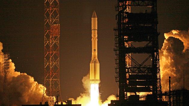
Russia lets anyone use Earth-sensing data from its civilian satellites
The US government has been willing to loosen its grip on satellite data, but what about the info from other countries? Don't worry, that's opening up as well. Russia has declared that the Earth-sensing data it collects from civilian satellites is now available to the public, not just the government -- if you want to track St. Petersburg's urban sprawl, you probably can. Officials are keen to tout the advantages for Russian businesses that rely on maps, but the move should also help anyone who wants a more complete picture of how the world works. [Image credit: AP Photo]

Topcon's IP-S2 Lite creates panoramic maps in 3D, spots every bump in the road (video)
You'd need only a smartphone app to pinpoint every pothole on your block, but to map out more severe structural damage, you'd probably need more sophisticated equipment -- which is where Topcon's IP-S2 Lite comes in. Unveiled at last week's 3D & Virtual Reality Expo in Tokyo, this road condition evaluation system is comprised of a 360-degree camera, GPS and an inclinometer. After using its camera to capture images at 16 frames per second, the IP-S2 analyzes the properties of every shot and uses this information to create 3D video footage. The contraption can also measure the height, distance and surface area of any given frame, allowing engineers to insert computer-generated images into the video (as pictured above) and to construct more accurate maps of disaster-stricken regions. In the wake of this year's devastating earthquake, for example, Japan's Geospatial Information Authority used this technology to map coastal areas of the Miyagi Prefecture, giving officials and rescue workers a better idea of the damage inflicted upon the region. You can find out more about the IP-S2 in the video after the break. [Thanks, Don]


