USGS
Latest
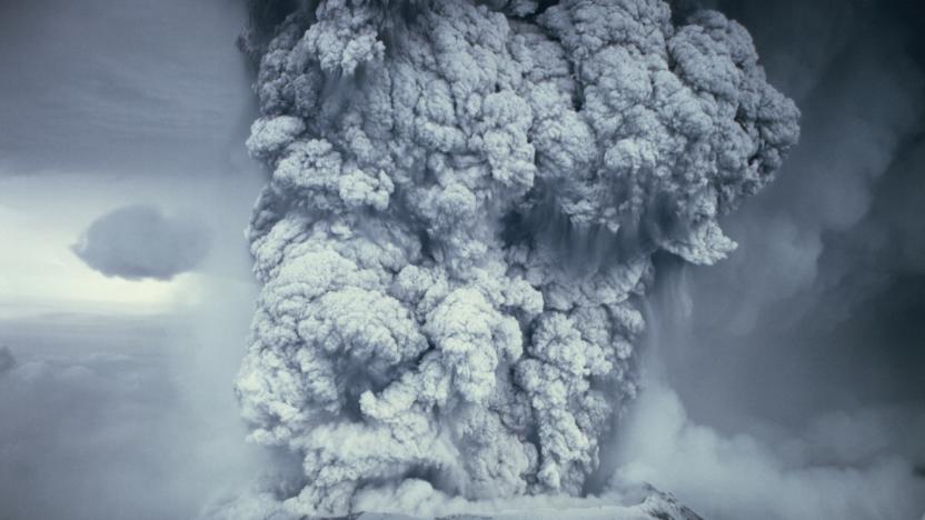
The USGS warning system that knows when rumbling volcanoes will blow their mountain tops
The National Volcano Early Warning and Monitoring System is standardizing and modernizing the nation's hodgepodge of USGS and academic volcano monitoring stations.
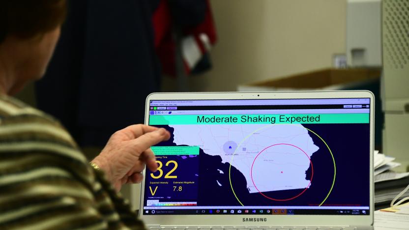
USGS earthquake warning system expands to cover entire West Coast
Washington residents will now receive mobile alerts about impending shaking.
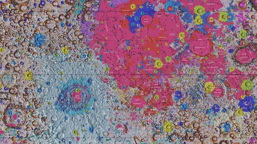
How NASA's new moon map will guide future manned missions
Now that NASA is planning new missions to the Moon with project Artemis, it needs the most detailed maps of our satellite ever produced. To that end, scientists from NASA, the United States Geological Survey (USGS) and the Lunar Planetary Institute have created a detailed new map in stunning color.

USGS releases first complete geologic map of the Moon
The USGS has made it easy to study the Moon's surface by releasing the first comprehensive geologic map of the lunar landscape.

California's statewide Earthquake Early Warning system sent its first alert
Two months after expanding across California, the state's Earthquake Early Warning system sent out its first real alert, notifying residents of shaking in Monterey and San Luis Obispo counties, along the San Andreas fault. While the quake eventually registered at 4.3 on the Modified Mercali scale, the USGS data shows it was initially estimated at 4.8, high enough to warrant an alert.

How conservationists are controlling invasive species in the 21st century
When humans colonized islands throughout the Pacific some 2,000 years ago, rats came along for the ride. The introduction of those rodents proved disastrous for the local island exosystem, a pattern than unfortunately continues to this day with no sign of slowing. Conservationists are now experimenting with high tech solutions to help keep invasive species in check.

Decades of spy satellite images help track melting Himalayan glaciers
You don't need cutting-edge satellite data to make sense of Earth's changing climate. Researchers have published a study of melting Himalayan glaciers that takes advantage of 40 years' worth of satellite imagery posted by the US Geological Survey, including declassified KH-9 Hexagon spy satellite photos from the 1970s and 1980s. The info not only let researchers cover a vast territory (about 650 glaciers over 1,240 miles), but made it possible to automatically create 3D models that reflected declining glacier elevations.

Google puts earthquake data directly in search results
For anyone who has had the pleasure of waking up to a rumbling apartment building, only to Google the USGS Earthquake map, the search giant is now saving you another click in your search results. Starting today, a Google search for "earthquake" or "earthquake near me" will put that same US Geological Survey data right in your search results.

Drilling makes Oklahoma as earthquake-prone as California
Drilling for oil and gas has made parts of Oklahoma and Kansas as likely to be hit by major earthquakes as California. A new United States Geological Survey (USGS) hazard map shows that the risk of a "damaging" quake within the next year is now as high in north Oklahoma -- 10-12 percent -- as anywhere else in the US. The revelation comes from the USGS changing the way it forecasts earthquakes in the country. In the past, its hazard maps only highlighted natural risks, meaning only California and small parts of Idaho, Montana, Nevada, Washington and Wyoming were mapped. Now, it factors in "induced earthquakes" triggered by human activity, with the primary cause being wastewater disposal from oil and gas production. This tainted liquid is injected into deep underground wells, which can lead to an increase in pressure that negatively affects the seismic stability of an area.

Stanford turns to Twitter to track earthquakes
It's easy to tell when an earthquake hits an area full of Twitter users -- there's frequently a rush of panicked tweets within seconds of the ground shaking. If Twitter and Stanford University have their way, though, those posts could be useful for more than just alerting friends. They've conducted research showing that geotagged tweets can help model the effects of a quake while it's happening. When you combine geological data with the volume of related tweets within a given radius, it's easier to determine the intensity of tremors and accurately track how they spread.

Up, up and down: The ephemerality and reality of the jetpack
Welcome to Time Machines, where we offer up a selection of mechanical oddities, milestone gadgets and unique inventions to test out your tech-history skills. Born out of sci-fi cinema, pulp literature and a general lust for launching ourselves into the wild blue yonder, the real-world Rocket Belt began to truly unfold once the military industrial complex opened up its wallet. In the late 1950s, the US Army's Transportation Research Command (TRECOM) was looking at ways to augment the mobility of foot soldiers and enable them to bypass minefields and other obstacles on the battleground by making long-range jumps. It put out a call to various aerospace companies looking for prototypes of a Small Rocket Lift Device (SRLD). Bell Aerospace, which had built the sound-barrier-breaking X-1 aircraft for the Army Air Forces, managed to get the contract and Wendell Moore, a propulsion engineer at Bell became the technical lead.

NASA launches Landsat 8 satellite to better study the skies above, water below
NASA's Landsat program recently turned the big four-oh, and what better way to deal with the mid-life crisis by getting a new satellite as a present? Accordingly, the space agency has just launched Landsat 8 into orbit to give its Earth Science program a new injection of youth. The new vehicle improves the accuracy of existing light and thermal sensors while widening the scope to better reflect modern climate studies -- number 8 now tracks aerosols in the atmosphere, high cirrus clouds and the telltale signs of water quality and consumption levels. We won't get the first USGS-derived results from the new satellite until after a 100-day shakedown period, but we're sure the deeper understanding of our planet will help the Landsat program forget all about those first few gray hairs.

US mineral companies to tech industry: drill, baby, drill
Even if your favorite gadget isn't flaunting them, rare earth metals are vital to all sorts of high-tech gizmos, from your flat-panel TV and computer hard drive to the hefty batteries that power the Toyota Prius. But over 95% of the world's rare earth comes from China; and late last year, China told the world that they'd like to keep the lion's share all to themselves. What will we Westerners do? Well, we could let China continue producing mountains of e-waste on our behalf. But we could also find plenty of rare earth just by digging in our own backyard. According to the U.S. Geological Survey, the United States has over 13 million metric tons of rare earth with concentrated deposits in Mountain Pass, California and Diamond Creek, Idaho. But since the private firms that control those deposits aren't willing to spend the requisite eight years and minimum $500 million to construct a chemical separation plant, Idaho-based U.S. Rare Earths is just sitting on their ore for now, while California's Molycorp Minerals is forced to send their material all the way to China (once again) for processing. "No one wants to be first to jump into the market because of the cost of building a separation plant," former USGS rare earth specialist Jim Hedrick told LiveScience. Should China's export dwindle and the U.S. feel the pinch, that may change, but for now it's good to know that when the global game of StarCraft tells us "not enough minerals," we'll know exactly where to look.


