AerialPhotography
Latest

1960s aerial spy photos reveal hidden archaeological sites
Archaeologists use satellite photos to spot potential archaeological sites, but urban sprawl and other human development has erased many traces of ancient civilizations. To get around that, Harvard's Jason Urs and Emily Hammer from the University of Pennsylvania figured out how to effectively go back in time to when the land was less despoiled. They dug up and archived a trove of U-2 spy photos from the '50s and '60s, eventually finding ancient canals and "desert kite" stone structures built in northern Iraq by the Assyrians up to 8,000 years ago.
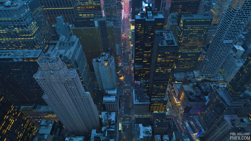
Watch a mesmerizing New York flyover shot with a 12K camera
Some folks believe that 8K TV is overkill, but cinematographer Phil Holland just flaunted video of New York City captured in sweeping 12K. He used three RED Weapon Monstro 8K VistaVision cameras (turned sideways) mounted on a special rig called the Shotover K1 Hammerhead. The videos were then stitched together to create a 12K, 48fps film with each frame equivalent to 100 megapixels, using a sensor area roughly equivalent to 645 medium format film.

Hover Camera is a safe and foldable drone that follows you
"Follow me" is an up-and-coming feature on consumer drones, and then you've also got those that are foldable for the sake of portability. Very few devices carry both advantages, but Beijing startup Zero Zero Robotics has already gone further with its Hover Camera. As the name suggests, this drone is mainly for aerial photography and videography, but what makes it even cooler is the fact that its propellers are fully enclosed by a strong carbon fiber frame, thus making it the safest drone we've ever played with. As you can see in our hands-on video after the break, you can literally grab it whenever you like without sacrificing any of your fingers to the drone gods.

FAA slaps drone video firm with record $1.9-million fine
It looks like the FAA is getting serious on unauthorized UAV flying. The department's just slapped SkyPan, a Chicago-based aerial video company, with a record $1.9-million dollar fine for violating flying regulations in its home city, and New York. The FAA states that SkyPan engaged in a total of 65 "unauthorized operations" between March and December 2012 -- 43 of them in NYC's highly restricted airspace.

DJI's sub-$800 drone packs smart features for first-timers
After the Phantom 3 Professional and the Phantom 3 Advanced, DJI's back with an even cheaper drone dubbed Phantom 3 Standard to tempt beginners. It costs just $799, which is $200 less than the Advanced and $460 less than the Professional, but you still get all the essentials: a built-in 3-axis stabilization gimbal, 12-megapixel still image capture (supports RAW shooting), up to 2.7K of video capture at 30 fps and 40 Mbps, video downlink at up to 720p and a slightly longer flight time of up to 25 minutes. The only real downside here is that the Standard can only transmit video back to your phone at up to 1km or 0.62 miles, which is half as much as the other two models.

GoPro-ready Ghost drone touts easy tilt control and auto-follow mode
As a recent South Park episode suggests, Parrot and DJI are the two most recognizable names in the consumer drone market right now, but they are about to face a new contender. Merely three months ago, we met Ehang who showed off its heavy-duty hexacopter at TechCrunch Beijing; and now, the Chinese company is also pushing its more affordable Ghost quadcopter onto Indiegogo. While said drone has been seeded to select e-tailers since April, Ehang co-founder Derrick Xiong said the latest offering is no longer a "beta version," but rather a retail-ready package aimed at the Western market. Most interestingly, the starting price is now just $375 -- a steal when compared to the $679 DJI Phantom 2 with similar specs.
DJI's Phantom 2 Vision takes a stabilized camera to the sky, we go hands-on (video)
You may not have come across DJI before, but this brand is no stranger in the world of hobbyist drones. Even production studios use the company's gear for aerial videography, but that involves a lot more money than the average consumer can stomach -- DJI's three-axis camera gimbal alone can cost up to $3,500, on top of about $3,000 for its latest six-rotor aircraft. And this is before you include a camera plus a remote control. Fortunately, we now have a more affordable option that still comes with camera stabilization: the Phantom 2 Vision. With a $1,199 price tag, this all-in-one package is aimed at prosumers who are looking for something more serious than, say, Parrot's AR.Drone series. While the latter's designed for entertainment, the Phantom 2 Vision gives you a taste of the advanced maneuverability and camera features from DJI's pro-level products. The relatively light 1.16kg drone features a built-in 14-megapixel camera (with a 1/2.3-inch sensor), which is mounted on a tilt-axis gimbal under the belly. The only bits that need to be installed are the four self-tightening propellers, along with a swappable 57.72Wh battery that lasts up to 25 minutes (but takes from one to two hours to fully charge when depleted).

New construction at Apple's North Carolina data center poses for aerial photographs
Photos courtesy of Wired reveal that Apple's new "tactical" data center at its Maiden, North Carolina facility is well on its way to completion. Captured with the help of a decidedly low-tech airplane -- a 1949 Piper PA-11 Cub Special, if you must know -- the shots feature what appear to be the facade of the $1.9 million, 21,000 square-foot structure that was outed last month. The images also show glimpses of a second 20-megawatt photovoltaic array and what may be the foundations of the complex's planned 4.8-megawatt biofuel cell plant, which will convert biogas into electricity. With Apple's upcoming Reno project getting the rubber stamp of approval, it doesn't seem like the company will run out of construction projects any time soon. Click on through to the source link for the full set of pictures and analysis.

Bing Maps piles on 215TB of new Bird's Eye imagery, proves it's a small world after all
Did you think Microsoft was done with Bing Maps updates after it threw a whopping 165TB of satellite imagery at virtual explorers? You've got another thing coming. The mapping crew in Redmond has thrown another 215TB of data over the fence, this time targeting its Bird's Eye views. Most of the attention is on Australia, Europe, New Zealand and Tokyo, although Microsoft has seen fit to sharpen up some of its US visuals in the process. All told, there's over 88,800 square miles covered by the new and updated aerial shots -- enough to make sure that we'll never have trouble finding Cinderella Castle at Tokyo Disneyland.

Google Earth 7.0 for Android brings new, super-detailed 3D maps for some cities (update: video)
Here's a bit of a surprise that slipped under the radar during the Google I/O keynote: Google Earth for Android has been updated to 7.0 to take advantage of the new 3D map technology it unveiled at another special event just a few weeks ago. As a refresher, the visuals are automatically created from 45-degree aerial imagery and can pick up 3D elements as subtle as trees. Before you go racing to your hometown to see how it looks in 3D, be aware that just a handful of cities and regions exploit that dimension. Besides San Francisco Bay, the full coverage extends to Boulder, Boston, Charlotte, Lawrence, Los Angeles, Long Beach, Portland, San Antonio, San Diego, Santa Cruz and Tampa in the US, with Rome being the lone international hotspot. If that's too few places to visit, there's always the addition of guided tours. Android users can head over Google Play to get the update today; iOS users shouldn't fret, as they'll get the new maps soon. Update: Google now has video, if you'd rather not (or can't) install the app to try it yourself.

Google Earth adds balloon and kite aerial imagery, invites you to contribute
Google Earth already offers quite a variety of ways to explore the planet, but the folks in Mountain View never seem content to leave things alone for long. Their latest addition is some aerial imagery of a slightly different sort -- images shot from ordinary balloons and kites. That initial batch of photos comes courtesy of The Public Laboratory for Open Technology and Science, which is itself a grassroots effort that anyone can contribute to. And that's apparently what Google hopes folks will do in order to expand the aerial views available -- as Google notes on its Lat Long blog, all that you need to get started is a digital camera and about $100 in parts, plus a little initiative. Complete details on how to start your own DIY mapping effort, or simply explore the options now available, can be found at the links below.

DJI multi-rotor aircraft with Ruling live video feed controller hands-on (video)
Well that's a mouthful. Shenzhen-based DJI Innovations was on hand at NAB today to demonstrate its new hex-rotor aircraft, designed to provide photographers (and videographers) with a low-cost tool for capturing aerial images. The vehicle we saw today, coined Spreading Wings S800 (its rotors retract for storage) is a fairly straightforward multi-rotor aircraft, save for a couple pretty slick enhancements. Even more impressive, however, was DJI's Ruling, a "ground control terminal" that enables you to adjust not only aircraft direction and elevation, but also the camera position, complete with a live video feed as captured by a Sony NEX-5N mounted on a multi-axis camera gimbal. The camera mount is designed to maintain a stable image regardless of the craft's position -- once it's fixed on a subject, it will adjust to retain the pre-selected angle. The Ruling controller is very much still a prototype, with a yet-unpolished military green plastic housing and a built-in LCD. There's also dual joysticks -- one on the left to adjust the camera platform, and a second on the right to control the aircraft itself, letting you climb, descend and turn in every which way with a flick. The duo was very responsive during a brief demonstration, making calculated movements with what looked to be precise accuracy. The video feed was interrupted slightly by the multitude of wireless connections littering the Las Vegas Convention Center airwaves, but reps were still able to verify framing and adjust position -- the aircraft itself never faltered, with a maximum range of 10 kilometers (5km for the video feed, in ideal conditions). The Spreading Wings S800 is available for pre-order now and is expected to ship next month for roughly $8,500. That clever live video controller will cost you another pretty penny, however, with an estimated $5,000 price tag and a TBD ship date. You'll want to take a closer look in the video after the break.

A video aerial view of Apple's NC data center
Apple's 500,000 square foot, US$1 billion data center in Maiden, North Carolina has been in operation for a while, and there's a huge 20 Megawatt solar power generation facility that's now under construction nearby. While Steve Jobs showed off the above photo of the interior of the facility at WWDC 2011 last year, it really doesn't show you how big the facility really is. Just to give you an idea of the scale and scope of the facilities that host iCloud and other Apple services, the good folks at Five 9s Digital went up in a small airplane this month to shoot the video that is embedded below for your viewing enjoyment. [via Dvice.com]

Lehmann Aviation's LFPV UAV packs GPS, autopilot, 11MP cam, 1080p video, yours for $2,352
Sure, an AR.Drone 2.0 will afford you 720p HD video recording in the skies for just 300 dollars, but how does 1080p with 11 megapixels of sensor sound in comparison? That's exactly what Lehmann Aviation is offering on its new LFPV civil UAV. This $2,352 (1790€) kit is far less expensive than the company's $17K LP960 from a few years back, but it certainly isn't lacking in the drool inducing features department -- and yes, it'll capture straight up photographs, too. Apart from letting you conduct reconnaissance of your local strip mall, the LFPV packs a "live data connection" to keep you informed about its GPS coordinates and altitude, among others things, like how soon you'll need to recharge. Better yet, it uses the same Ground Control System as Lehmann's other flyers (perfect for when it's time to upgrade), offering an 800 x 480 live video stream of your journey and total control of where you're piloting the aircraft. Best of all, the LFPV even packs autopilot if you need to take a break from the controls . We'd be remiss not to point out Eye3's $999 bring-your-own-camera hexicopter for those already equipped with a beefy ILC shooter, but if the LFPV is right up (or over) your alley, you'll find a full press release and video just past the break.

German video effects company builds camera drone for the Red Epic
Red Epic + Flying drone = The sort of geek math you can't help but wish you'd come up with yourself. German VFX company OMStudios decided to mount Red's super-camera into a custom Octocopter to record footage in resolutions up to 5K. As cool as the setup is, there's a practical purpose: not only is it far cheaper than renting a crane, it can also climb up to 150 meters -- making it just high enough to fly over Hollywood's tallest man, Tom Cruise. Since it's highly unlikely we'll ever get to play with one of these, we'll just have to point you to the video after the break and hope that no catastrophic power failures take place halfway through any real-world shoots. [Thanks, Jeremias]

Microdrones' flying robot films African wildlife, finds peace with nature
Sit back, relax and grab a cold one, because you're about to take an aerial tour of the Serengeti, courtesy of that flying drone you're staring at. Developed by Microdrones, this MD4-100 quadrotor was recently sent off to Kenya, where it gathered footage for a TV nature documentary produced by TBS Japan. By hovering over the terrain, the craft was able to get relatively up close and personal with zebras, elephants and other wildlife, without creating the same kind of disturbance that heavy duty, camera-laden trucks can wreak. Presumably, that's because the animals have no idea what to make of a flying robot, though part of us wants to believe there's some sort of full-circle, techno-evolutionary dynamic at work here, momentously bringing bot and beast together in some sort of pre-apocalyptic symbiosis. But that's just us. Hover past the break to see the video for yourself.

Pix4D turns your 2D aerial photographs into 3D maps on the fly (video)
Assuming you own a Sensefly Swinglet CAM or some other high-res camera-equipped UAV, you could be just minutes away from turning your plain old 2D aerial photos into comprehensive 3D maps. Pix4D, a new software program coming out of EPFL -- the same institute that brought us this race of altruistic robots -- takes images shot using an aerial drone to render 3D maps in the cloud in just 30 minutes. Users upload images taken with their flying machines, at which point Pix4D kicks into action, defining high contrast points in the phots and pasting them together based on those points. It then renders a 3D model, overlays the graphics, and spits out a Google Earth-style map. So what's with this 4D business? Well, its developers claim that users can easily see the progression of any model by deploying their Sensefly drone whenever they see fit, throwing the added layer of time into the mix. You can see the fruits of Pix4D's labor in the video after the break.

RED ONE mounted to UAV, flown around San Juan Island (Update: false alarm, it's a Panasonic)
Never one to miss a chance to feature action-packed UAV footage on this space, here we have a behind-the-scenes look at the new Mt. St. Helens Vietnam Band video for you. While it ain't exactly Hearts of Darkness or Burden of Dreams, sometimes there are more important things than pathos, obsession, and heartbeak -- in this case, up close and personal shots of AerialPan Imaging's custom-built remote control camera rig, complete with mounted RED ONE HD video camera. Not too many technical details for you, but there is enough remote controlled helicopter excitement to make you wish you were on location at San Juan Island with one of these bad boys. Check it out for yourself after the break. Update: As one of our colleagues (and a couple eagle-eyed readers) so graciously pointed out, the camera mounted to the helicopter has the tell-tale markings (peep the on-board mic) of a Panasonic HVX200. Thanks, kids! [Via CNET]

DraganFlyer X4 UAV puts the camera where it needs to be, even when the floor is lava
It's been a while since we've heard from Draganfly, a name familiar to connoisseurs of unmanned aerial photography. The company's latest outing, the DraganFlyer X4, is a four-rotor UAV that measures only 30.5-inches across and since it ships with your choice of either a Panasonic Lumix DMC-FX580, Watec WAT-902H2 Ultimate (for shooting in low light), FLIR Photon TAU (infrared), or the Highg Res 480 Board Camera (analog motion video with an 8GB DVR), we imagine that this thing ain't going to be cheap. That said, if you are a well-heeled creepy stalker, southern border vigilante, or even someone with legitimate military / industrial business, there are plenty of features to make it worth a second look, including: computerized stabilization, altitude hold (maintains its position in the air without user input), and an automatic landing feature that kicks in if the control link is lost. But most importantly for the airborne auteur, this guy sports a wireless video downlink that sends the viewfinder signal that can be displayed either on the device's handheld controller or a pair of video goggles, allowing real-time manipulation of zoom, tilt, and shutter settings. Get a closer look at the thing after the break.

Microsoft's Vexcel Imaging announces 92-megapixel UltraCamLp
Microsoft's Vexcel Imaging division hasn't exactly caused a whole lot of fanfare during its short time in existence, but it has managed to carved out a nice little niche for itself in the field of aerial cameras, and it's just kicked out its latest model in the form of the 92-megapixel UltraCamLp. Apart from that boost in megapixels, this one looks to be mostly identical to the medium-format UltraCamL that it's based on (pictured above), although it does make use of a smaller 6 μm CCD array that makes that increase in image format possible. Otherwise, you can expect a 1:2.2 pan sharpen ratio, and the ability to collect RGB and NIR in parallel with forward motion compensation by TDI, which will let you use the camera in a whole host of applications ranging from orthophoto production to corridor mapping to lidar integration. No word on price just yet, but it looks like existing UltraCamL users will be eligible for a free upgrade when the UltraCamLp rolls out in November.[Via GIM International, thanks Thijs]


