googleearth
Latest

Dr. Julius Neubronner's fantastic flying cameras
The first aerial photograph was taken in 1858 by Frenchman Gaspard-Félix Tournachon, also known by his alias Nadar, from a tethered gas balloon suspended over Paris. While the images captured on this flight have since been lost to time, there are plenty of surviving examples of aerial photographs shot during the latter half of the 19th century. In addition to balloons, kites and rudimentary rockets were used to send cameras skyward. Even Alfred Nobel was drawn to the practice, with one of his last patent applications being for a method for rocket photography. It's hard to grasp how challenging this was at the time. We need only load up Google Earth to see our house from space, or buy a hobbyist drone to capture our own aerial panoramas. Long before satellites and quadcopters, though, Dr. Julius Neubronner started strapping cameras to pigeons.
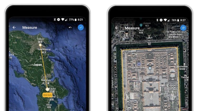
Google Earth can measure the distance between your house and the Louvre
Not content to simply measure kitchen tables using augmented reality anymore, Google is thinking bigger. A lot bigger. The latest update to Google Earth is the ability to measure the distance between two points on the globe. In a blog post, the search juggernaut says that it's been one of the most requested features. The Measure tool goes live in Chrome today and will be added to Android this week, with iOS getting in on the party "soon."
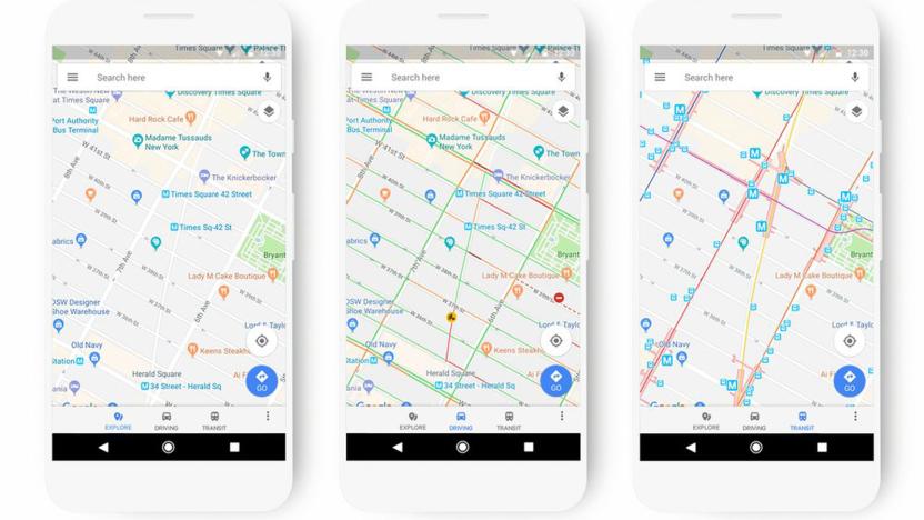
Google Maps' new look adapts to how you travel
Google Maps may be a cornerstone of navigation for many people, but its visual presentation can occasionally leave something to be desired. Why would you care about gas stations when you're taking the subway? To that end, Google is giving Maps a fresh look that adapts to your travel methods and what you're looking for. If you're taking public transportation, it'll highlight stops and route lines; if you're exploring the area, it'll focus more on points of interest. Each location type will have distinct colors and icons, too, so it should be easier to find a restaurant or movie theater if you're new to the area.
Google Earth is almost ready to work on Firefox
Earlier this year, Google Earth finally became accessible on a browser, giving you a way to virtually explore our world without having to install its application. At the moment, though, it will only work if you're using Google Chrome, something its developers are working hard to change: their official Twitter account has just revealed that they're making good progress on bringing the web-based app to Firefox.
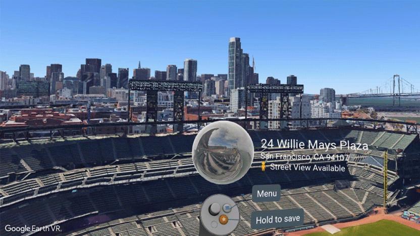
Google Earth VR gets new Street View images
Google announced today that it's adding Street View to the Google Earth VR experience. With a new update, users can check out Street View images from 85 countries provided by the Street View team as well as pictures shared by others from around the world. To get there, while in Earth VR, zoom down closer to the street level and see if your controller says there's Street View imagery available. If so, you can then view the area within a 360 degree photo.

Google Earth iOS update saves it from App Store removal
One of iOS 11's big changes (and there are many) is that it will no longer support 32-bit-only apps. This has left developers scrambling to make sure their apps will be able to launch on the software update arriving in September. It's understandable that smaller developers might make it just under the wire, but it's a little surprising that a company with the resources of Google would wait until the last minute. Today, the tech giant finally released a new version of Google Earth that has 64-bit support.

Google wants more Google Earth content via your local stories
Google is planning to make Google Earth a lot more social. In the next few years, you will be able to share personal images and videos to the platform. As a result, Google envisions millions of public "stories" populating the tool. Viewers will then be able to spend even more time procrastinating by dipping in and out of the clips as they explore the global simulation.

Google gives students interactive tools for STEM and internet safety
Google launched a new browser-based Google Earth this past April, adding educational tools to make it easier for teachers to show the world off to students without having to leave the classroom. The company also collaborated with the BBC to create a digital storytelling platform called Voyager that helps curate the discovery of various places of interest around the globe. Google is taking things even farther today at the International Society for Technology in Education (ISTE) conference, announcing a bevy of new tools and virtual experiences to empower students.
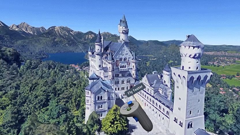
Explore the world with Google Earth VR on Oculus Rift
The Google Earth revamp isn't just focused on the web and mobile crowds -- there are a few perks for virtual reality fans as well. Google has updated Earth's free VR experience to support the Oculus Rift headset and its Oculus Touch controllers. You no longer need HTC's Vive to fly over landscapes, including 27 new ones like Germany's Neuschwanstein Castle or South Africa's Table Mountain. It'll no doubt seem familiar if you've tried it before, but there is big interface update to go along with the widened hardware support.

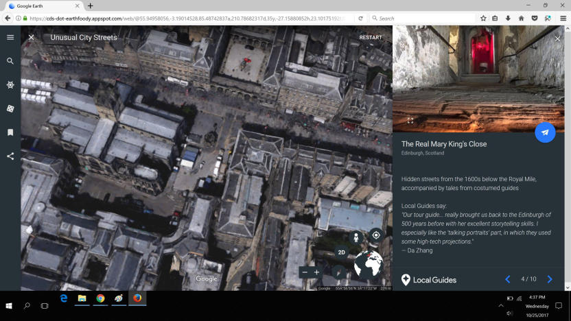
Google Earth feeds your wanderlust with 'Voyager' stories
There are two things you should never do if you want to maintain productivity: start clicking on links in Wikipedia, or open Google Earth. There are many, many other ways to waste time on the internet but the amount of work hours lost between those two is probably enough to make most managers weep. Your boss won't be too pleased, then, to learn that Google Earth's latest update, revealed today, ratchets up its time-killing potential several notches.

A 'brand new' Google Earth will arrive April 18th
Google just sent out invites for a pre-Earth Day event in New York City next week. In keeping with the obvious theme, the search giant is promising to take the lid off of a "brand new experience" for Google Earth.

Google timelapses offer a 32-year look at Earth's history
As static as it may seem, Earth is a lively planet that changes almost constantly -- and Google just offered a clever way to see that development with your own eyes. In a partnership with Time, it's introducing a dramatically improved version of Google Earth Timelapse that provides animated satellite imagery covering 32 years, going back to 1984 (4 years earlier than before). It uses the higher-resolution maps you saw in June to provide a look that's both more detailed and more seamless than before, with fewer abrupt changes in color and quality. There's also more to look at in the first place thanks to both added legacy satellite data and info from newer orbiters.

Google Live cases show trending topics on your Pixels' screens
Google has launched two new Live case lines for its Pixel phones that come with their own live wallpapers, and one of them's a lot more relaxing than the other. The Google Earth Live cases feature beaches, ice formations and other beautiful photos of our planet taken from the company's satellite imagery. While each case matches a specific Google Earth photo, their live wallpaper changes everyday using a rotation of curated images from the program. You'll also find a shortcut button on the home screen that you can tap to explore the specific location currently shown on your screen.

ICYMI: Virtually globetrot in Google Earth
try{document.getElementById("aol-cms-player-1").style.display="none";}catch(e){}Today on In Case You Missed It: Google Earth just released an update that supports virtual reality, letting users teleport all around the globe, easily. So far it's free in Steam so anyone with an HTC Vive: Get going. Meanwhile Urban Aeronautics took its first pre-routed flight with a autonomous flying machine meant to be the air taxi first foretold in The Fifth Element. The 'ticking a GoPro on things' video from Sam and Niko is here, 'Quick, Draw!' is here (and God have mercy on your self-esteem if you ever play it). As always, please share any interesting tech or science videos you find by using the #ICYMI hashtag on Twitter for @mskerryd.

Google Earth is now available in VR
The virtual whole-Earth model that Google has been perfecting for over a decade has finally reached its next big step: Google Earth is now available in virtual reality. For the first time, users can walk through real city streets, fly through canyons and teleport to anywhere in the world all in an completely immersive VR experience.

Google brings higher-resolution imagery to Earth and Maps
Every few months or so, Google improves the satellite imagery on services like Earth and Maps. Now, as part of its efforts to keep making the experience better for users, the search giant is going to offer higher-resolution virtual views going forward. You'll now notice sharper imagery of areas around the world, thanks to the latest data from the Landsat 8 satellite and "new processing techniques" that Google's implementing.

Google Earth gets two new features for its 10th birthday
Can you believe that Google Earth has been around for a full decade now? To celebrate this milestone, Google unveiled a pair of striking new (and expanded) features to the planet virtualization system on Monday. The first is Voyager, which available on the desktop edition. It's designed to help you pick out and explore the coolest and newest imagery from around the world. These are organized into five categories: Street View, Earth View, 3D cities, Satellite imagery updates, and Highlight tour.

Google makes Earth Pro available to virtual travelers for free
While we're sure Google Earth works just fine for your daily virtual 'round-the-world travels, the Pro version comes with some really useful features -- even better, it's now completely free. Google Earth Pro, which used to cost an eye-watering $399 per year, gives you the tools to measure 3D buildings and other locations, print high-resolution screenshots, view demographic and traffic layers, and even record your virtual trips. To use it for free, you'll first need to sign up for a license and make sure your PC or Mac meets the minimum system requirements needed to run the program.

Google Earth's third-party app support is going away, for now
Google Earth's technology has led to some pretty cool third-party projects over the past six years, but you may not see many of those efforts for at least a little while. Google has announced that it's retiring Earth's app programming interface within a year. Any mapping software built using that kit will stop working on December 12th, 2015. As the company explains, it's simply a matter of security. Chrome and Firefox are phasing out support for the old, vulnerable Netscape plugin format that Earth uses for third-party web apps, and Google doesn't want to leave people open to attack. This isn't necessarily the end for broad Earth support, mind you. Google notes that "3D is in [its] blood," and is teasing that there's more in the pipeline. It's not clear that this includes a new toolbox, but you may not have to worry about a dearth of clever maps just yet.
Google Earth for Android is now faster, better at 3D exploration
Heads up, Android fans: Google Earth for your phones is about to get a lot better. That's what the folks in Mountain View are promising, anyway -- they've released an update to the app brings with it snappier performance and improved labels for maps (you'll never wonder where Foster City and Redwood Shores begin and end again). Perhaps the biggest change, though -- a completely rebuilt 3D rendering engine -- means those cityscapes and mountain ranges you pore over should show up with more crispness and clarity. Try not to lord that over your friends using Apple Maps, will you? Throw in a way to import your own custom .KML files into the app from Google Drive and you've got all the makings of a pretty momentous update. Itching to take it for a spin? Mosey on over to the Google Play Store to get your globetrotting fix.


