googlestreetview
Latest
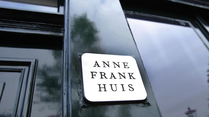
Google takes you inside Anne Frank's childhood home with Street View
June 12th is the 90th birthday of Anne Frank, and to mark the occasion, Google is letting you step inside the childhood home of the diarist. A virtual exhibit in the Arts & Culture app and website takes you inside Merwedeplein 37-2 in Amsterdam. You can also explore the space through an indoor version of Street View. All the 1930s-styled rooms of the home, which is now a temporary home and work space for refugee writers that's closed to the public, are viewable.

Researchers tap AI for more efficient road maintenance
Potholes are a nuisance pretty much everywhere and the methods traditionally used to keep track of them aren't terribly efficient. Whether it be driving around to visually inspect roads or watching videos of streets to spot and prioritize the repair of pavement damage, strategies typically used by towns and cities require a fair amount of time and labor. But AI could make that process a bit easier and quite a bit faster. One group exploring the use of AI to support the municipal officials in charge of road maintenance has been developing a software system that could not only aid in road repairs but also bridge and building maintenance as well.

Google's Street View cars will monitor London's air quality
London Mayor Sadiq Khan has made it one of his missions to curb pollution and improve air quality in the capital. Data plays an important role, and as part of a new project, two Google Street View cars will begin pulling double duty as mobile air quality monitors next month. The vehicles have been fitted with sensors that will measure pollutant levels, as well as temperature, humidity and pressure, once every 30 meters as they wind their way around London. This data will be used to complement readings from another 100 static sensors dotted around the city. London has several veteran sensor networks and is no stranger to shorter-term monitoring projects, but this new initiative is said to be on a different scale, capable of painting a near real-time, "hyperlocal" picture of air quality across the capital.

Google makes it easy to create your own VR tours
With Google Expeditions, you can take tours of ancient sites like Machu Picchu, visit attractions like the Burj Khalifa or even take a trip to the International Space Station and now Google is making it easier to create tours yourself. With a new platform called Tour Creator, anyone can now put together a VR tour of whatever they'd like using their own 360-degree photos and Google Street View images. "The tool is designed to let you produce professional-level VR content without a steep learning curve," says Google.
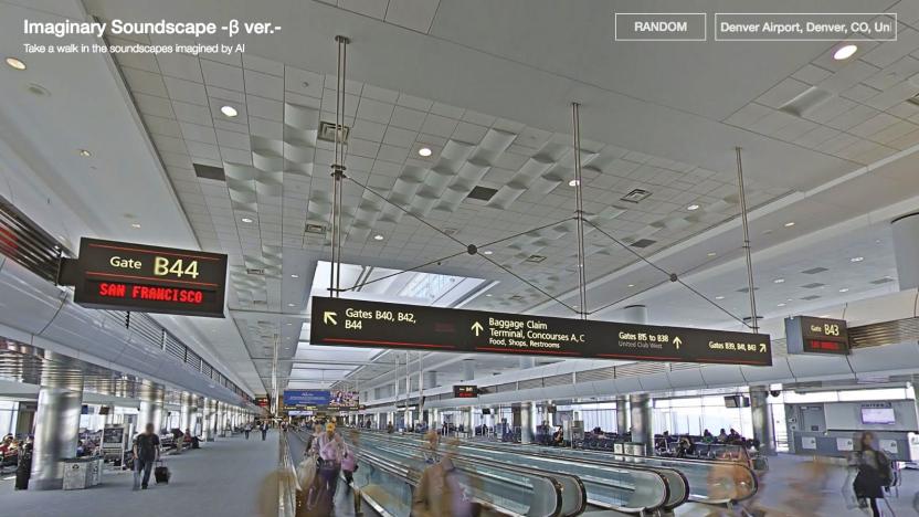
AI adds background noise to Google Street View scenes
Google Street View is a great way to imagine you're somewhere else, walking the streets of a bustling foreign city or making your way through a quiet, tree-lined neighborhood. Now, thanks to a project from Nao Tokui, it's become even more immersive. He's put together a feature called Imaginary Soundscapes that creates background noise based on what you're looking at in Google Street View. It's a soundtrack for your virtual walks that was first identified by the Tumblr user Prosthetic Knowledge.
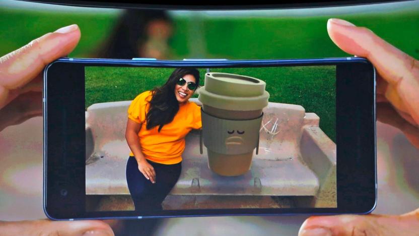
Google goes full Snapchat with AR stickers for Pixel phones
Last month, Google gave us a look into what it's been doing with ARCore -- the company's augmented reality developer platform for Android. Some of the platform's capabilities already include incorporating Street View images, providing step-by-step training tutorials and showing previews of what construction projects will look like once they're finished. And today at Google's Pixel 2 event, we got another look at what the platform can do.

Google's new Street View cameras help AI map the real world
Google's Street View cameras haven't changed significantly in 8 years, and that's a problem when the technology world most certainly has. How is the company supposed to fulfill its AI ambitions with 2009-era hardware? Thankfully, it won't have to. Google has revealed to Wired that it's implementing a brand new camera design that should not only produce higher quality Street View imagery, but will prove crucial to Google's use of AI to index real-world locations.
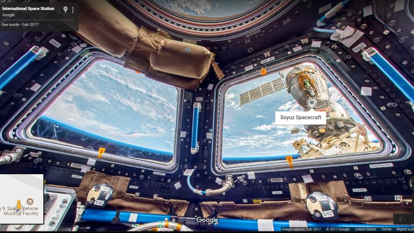
Google Street View takes you aboard the ISS
Astronauts aboard the International Space Station just got an adorable floating camera, but what do we get? While nobody's handing out free rides to the ISS, you can digitally explore it now that it's up on Google Street View.

One man is cycling the length of Britain in VR
Exercise bikes can be a little boring. Even with some music or mindless TV in the background, it's a mind-numbing workout. Pedalling, pedalling, pedalling. Not for Aaron Puzey. The Brit has developed an app for Samsung's Gear VR headset which displays Street View imagery while he's riding. Using a Bluetooth cadence sensor, which tracks how fast he's pedalling, the app knows when to manipulate and change the panoramas, giving the impression that he's travelling. His goal? To ride the length of Britain, from Land's End in Cornwall to John O'Groats in Scotland.

Island dwellers map their country with Sheep View 360
Google has captured all kinds of places on cam for Street View, from the Batcave to Mt. Everest, but it hasn't had the chance to visit the Faroe Islands yet. The tiny and remote archipelago in the middle of the North Atlantic Ocean has almost twice as many sheep (80,000) as people (49,188). So when one of its residents decided to take matters into her own hands, she enlisted the help of five fluffy ruminants for a project that's aptly called Sheep View 360.

Explore the 'Batman v Superman' Batcave on Street View
Whether you think Batman v Superman is a masterpiece or an underwhelming mess, it's hard not to be impressed by the new Batcave. It's a stylish take on the Dark Knight's lair and now, you can explore it for yourself through Google Street View. You'll start on the surface, inside Bruce Wayne's lake house. Click through and you'll quickly stumble upon the subterranean base, complete with the Batmobile and a glass cabinet containing a Joker-graffitied Robin costume. The armored Batsuit and Batcomputer reside upstairs, along with plenty of other weapons and R&D projects. The grapple guns on the ground floor are a personal favorite.

Google Street View takes you on a South African safari
So you've wanted to see African wildlife in its native habitat, but the prospect of booking such an expensive trip makes your bank account weep. What to do? Google can help. It just introduced the Mzansi Experience, a virtual visit to South Africa that uses Street View to give you a sense of the country's grandiose landscape. On top of seeing elephants, leopards and other fauna, it'll take you to everything from Cape Town's Table Mountain through to Durban's Golden Mile. While this still won't be as awe-inspiring as a real safari, it'll require much less effort... and it might even inspire you to go when your finances allow.

Google gives My Maps for Android a much-needed revamp
Google's My Maps for Android hasn't received a lot of affection lately, but the company is making up for that in style. It quietly released a big upgrade to the custom mapping app that, on top of a "new look and feel," throws in features that arguably should have been there ages ago. You can see Street View imagery for all your map points, to start with -- you'll know what your destinations look like on the ground without having to jump to Google Maps. You can also see photos and videos that were added on the web, and the app should be much faster as a whole. Give it a spin if you're planning a big trip, or just want to document your favorite haunts.

Google brings 40 US national parks to Street View
Google just made it easier to visit some of the US' biggest landmarks without hopping on an airplane. It's teaming up with the National Park Service to offer 360-degree Street View imagery for 40 national parks and historic sites, ranging from Alcatraz's legendary prison to the ancient cliff dwellings of Montezuma Castle. The collection also touts photos of artifacts from those locations. Want to see furniture from Abraham Lincoln's house? You can. No, this won't recreate the grandeur you'd get from being there yourself, but it beats having to rely on tourists' photos to get a feel for what you're missing.

Google Street View gives you a tour of ancient Jordan landmarks
Jordan is home to some extremely significant historical and religious sites. However, visiting those landmarks in person is no mean feat -- which is why Google just added many of them to Street View. Fire up your web browser and you can get virtual, 360-degree tours of more than 30 ancient locations, including the city of Petra (above), Jerash and legendary castles from the Crusades. We suspect that this will pale in comparison to the grandeur of seeing these relics first-hand, but you should at least have an inkling of what the experience would be like.
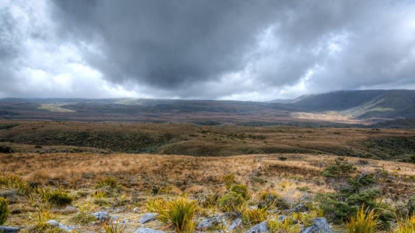
Explore New Zealand's 'Great Walks' with Google Street View
If you want to take a trip to Middle Earth tonight but don't have a passport, Google's got you covered with a new addition to Street View. The internet juggernaut's partnered with New Zealand's Department of Conservation to use Google Trekker to create some pretty rad 360 degree panoramas of the country's most stunning vistas, the "Great Walks." It isn't the first time Mountain View's gone someplace that inspired a movie before, and hopefully it won't be the last. The real question here is if that's an ent moot off in the distance or just your eyes playing tricks on you.

Google buys a panorama startup to bolster Street View
Think that Google Street View could use a fresh coat of paint? Google does, too. The search firm has just snapped up Digisfera, a Portugese startup whose specialty is making the most out of panoramic photos. The newly-acquired company isn't saying exactly what it'll do within the Street View team, but its work on some more ambitious projects may be a clue. It produced a giant tagged panorama at the 2014 World Cup, for example, and captured a sweeping view of President Obama's inauguration.

Google's new Street View app lets you add your own spherical photos
In the midst of IFA's volley of tech hardware news, Google Maps has announced a spin-off Street View app that allows you to upload your own spherical photos. Yes, you're now a human Street View car. The app lets you not only shoot photo spheres from your phone but also connect directly to spherical cameras, like Ricoh's Theta camera series. The announcement came alongside the latest Theta camera, which is of course compatible with the new feature. It sounds like Street View will turn into a combination of Google's own photography and crowdsourced spheres. Charles Armstrong, Google Maps product manager, said the new app will allow "people all over the world to explore user contributions, Google's own imagery, and their own published photo spheres through a seamless world map of landscapes, landmarks, business interiors and more."

Google's DeepStereo makes Street View 'tourism' more realistic
Who here uses Street View to do some virtual traveling? It's not a shabby option if you want to look at places you might never visit within your lifetime, but Google thinks there's still a better way to simulate real-world tours. A team of the company's researchers has developed a technique that uses Google's experimental machine vision algorithm called DeepStereo to transform Street View panoramas into seamless virtual tours. See, Street View photos don't usually capture every detail of a location -- there are always a few frames missing in order to construct convincing digital reproductions of places like museums and houses. DeepStereo can synthesize those missing frames based on the ones that go before and after them, giving Google the ability to create realistic virtual tours.

Computers are learning to size up neighborhoods using photos
Us humans are normally good at making quick judgments about neighborhoods. We can figure out whether we're safe, or if we're likely to find a certain store. Computers haven't had such an easy time of it, but that's changing now that MIT researchers have created a deep learning algorithm that sizes up neighborhoods roughly as well as humans. The code correlates what it sees in millions of Google Street View images with crime rates and points of interest; it can tell what a sketchy part of town looks like, or what you're likely to see near a McDonald's (taxis and police vans, apparently).


