Landsat8
Latest
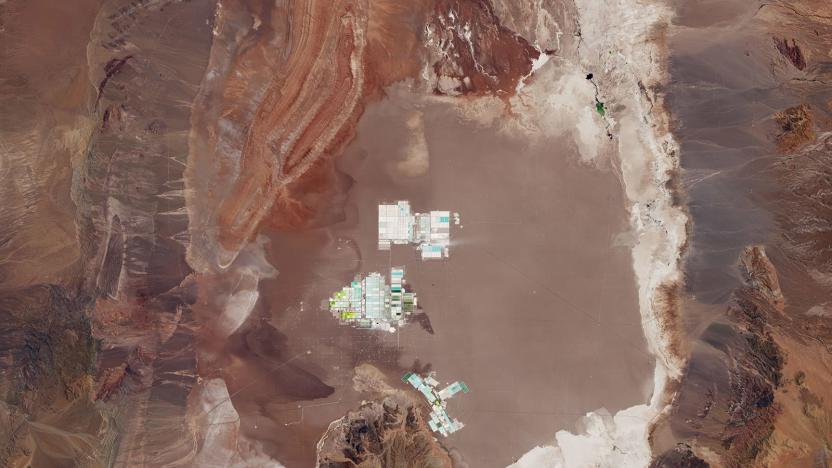
EV batteries are born in Chilean evaporation ponds
Using Landsat data from the US Geological survey, NASA's Laren Dauphin recently imaged the Salar de Atacama in Chile. The enclosed basin is the world's largest source of lithium, producing 29 percent of the world's reserves. Much of it will wind up in rechargeable batteries used by EVs, laptops and smartphones, but how it gets there is surprising -- think salt production, not pit mines.

Google brings higher-resolution imagery to Earth and Maps
Every few months or so, Google improves the satellite imagery on services like Earth and Maps. Now, as part of its efforts to keep making the experience better for users, the search giant is going to offer higher-resolution virtual views going forward. You'll now notice sharper imagery of areas around the world, thanks to the latest data from the Landsat 8 satellite and "new processing techniques" that Google's implementing.

Google refreshes Maps and Earth with 800,000 megapixels of new satellite imagery
It's not easy being a satellite; permanent imaging gear becomes outdated mere months after launch, and Mother Nature is constantly caught photobombing close-ups, throwing naughty clouds between a lens and the shot. All that makes for some pretty inconsistent online viewing. Fortunately, Google's stepped in to set things straight, combining the magic of photo stitching with the capture power of a brand-spanking-new Landsat 8. The result is a cloud-free planet, enabling millions of web-equipped "explorers" to realize improved aerial views as seen from 438 miles above sea level. It's pretty spectacular, and it's about friggin' time.

NASA launches Landsat 8 satellite to better study the skies above, water below
NASA's Landsat program recently turned the big four-oh, and what better way to deal with the mid-life crisis by getting a new satellite as a present? Accordingly, the space agency has just launched Landsat 8 into orbit to give its Earth Science program a new injection of youth. The new vehicle improves the accuracy of existing light and thermal sensors while widening the scope to better reflect modern climate studies -- number 8 now tracks aerosols in the atmosphere, high cirrus clouds and the telltale signs of water quality and consumption levels. We won't get the first USGS-derived results from the new satellite until after a 100-day shakedown period, but we're sure the deeper understanding of our planet will help the Landsat program forget all about those first few gray hairs.


