noaa
Latest
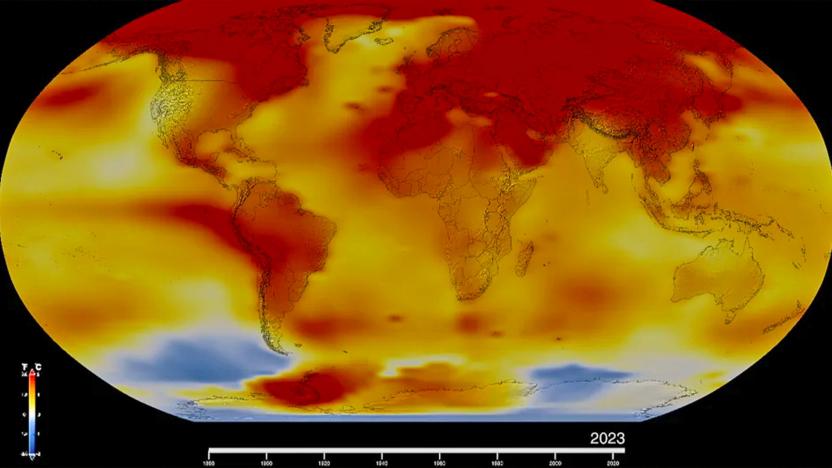
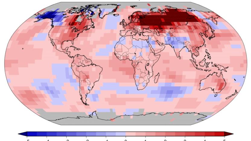
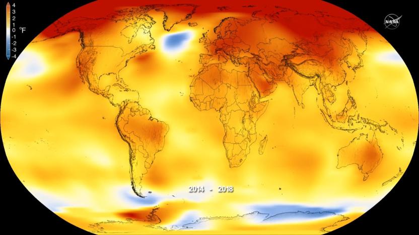
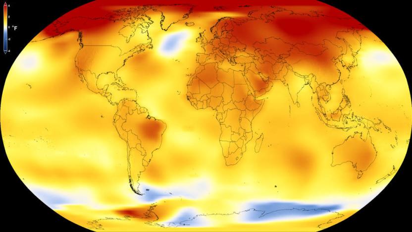
NASA confirms 2023 was the hottest year on record
NASA just released its annual global temperature report and, well, 2023 was the hottest year since measurements began in 1880. Additionally, the U.S. National Oceanic and Atmospheric Administration (NOAA) reported that 2024 could be even hotter.
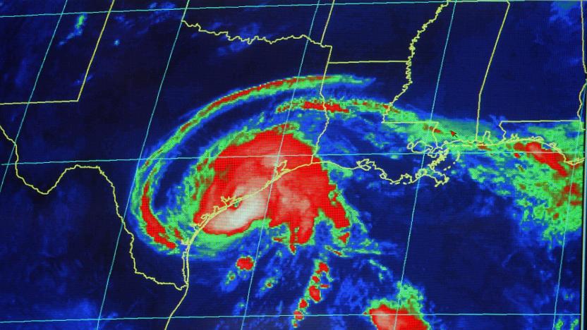
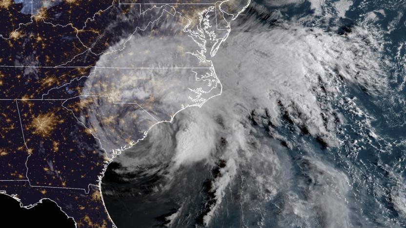
Hitting the Books: How hurricanes work
In his new book, Looking Up: The True Adventures of a Storm-Chasing Weather Nerd, Matthew Cappucci mixes anecdotes from his meteorological career with explanatory science to share with readers his passion for the weather.
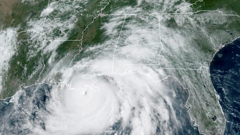
NOAA triples its supercomputing capacity for improved storm modeling
The NOAA is tripling its supercomputing capacity ahead of hurricane season.
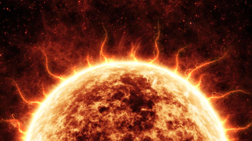
How NASA spots potentially catastrophic geomagnetic storms before they strike
Geomagnetic storms pose an ongoing threat to the world’s electrical infrastructure interrupting broadcast and telecommunications signals and damaging electrical grids. Here's how we spot them before they strike.
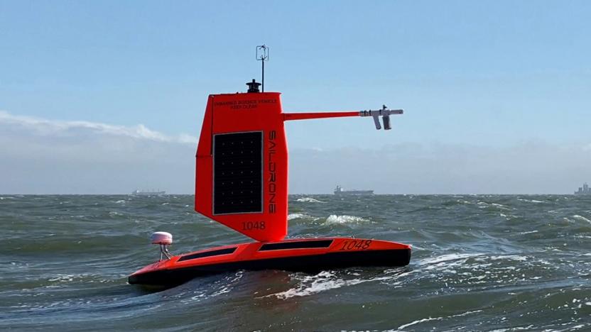
NOAA's surfing drone captured footage inside Hurricane Sam
The agency says data collected by saildrones could help improve storm forecasting.

The COVID-19 shutdown is making weather prediction more difficult
The COVID-19 quarantine is grounding airlines around the world and that's hindering our ability to predict the weather.
Last month was the hottest January on record
In 141 years of climate records, January 2020 was the hottest January yet, according to scientists from NOAA's National Centers for Environmental Information. Global land and ocean surface temperatures were 2.05 degrees Fahrenheit (1.14 degrees Celsius) above the 20th-Century average, beating the previous record set in January 2016 by 0.04 degrees F (0.02 degrees C).
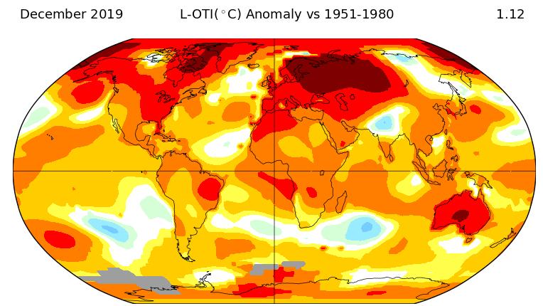
2019 was Earth’s second-warmest year on record
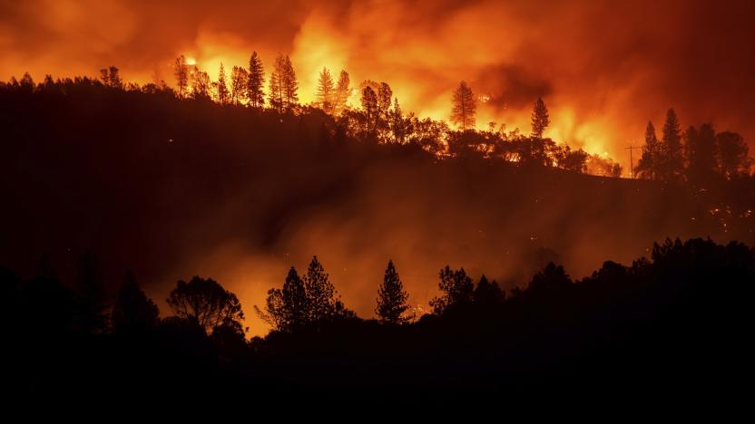
If the melting ice caps and recent wildfires didn't tip you off, NASA, the National Oceanic and Atmospheric Administration (NOAA), and the World Meteorological Organization (WMO) have hard data showing that the effects of climate change are only getting worse. According to the agencies, 2019 was the second hottest year since record keeping began in 1880, and was only topped by 2016's temperatures. The trend is clear: Every decade since the '60s has, on average, been warmer than the one before it. Even more alarming is the fact that the past five years have been the hottest five on record.
US weather forecast model gets a much-needed upgrade
Meterology revolves as much around good weather models as it does good weather data, and the core US model is about to receive a long-overdue refresh. NOAA has upgraded its Global Forecast System with a long-in-testing dynamical core, the Finite-Volume Cubed-Sphere (aka FV3). It's the first time the model has been replaced in roughly 40 years, and it promises higher-resolution forecasts, lower computational overhead and more realistic water vapor physics.
Senators ask the FCC to limit 5G auction to protect weather forecasts
In March, the Federal Communications Commission (FCC) began auctioning blocks of the 24 GHz spectrum, which could be used to implement future 5G networks. Shortly afterward, the US Navy released a memo warning that 5G in the 24 GHz band could interfere with weather satellites. Now, Senators Ron Wyden (D-Ore.) and Maria Cantwell (D-Wash.) are urging the FCC not to allow wireless companies to operate 5G in that spectrum until weather forecasting operations are protected. The Senators wrote a letter to FCC Chairman Ajit Pai yesterday, citing the Navy's memo and accusing the FCC of ignoring "the serious alarms the scientific community is raising."
CO2 levels are the highest since humanity began
CO2 levels on Earth have officially hit 415 parts per million (ppm), according to readings taken at the Mauna Loa Observatory in Hawai'i. That's the highest level since homo sapiens came onto the planet, meteorologist Eric Holthaus tweeted, and represents an increase of 15 ppm over just the past three years. "We don't know a planet like this," Holthaus said.
2018 was the fourth-hottest year on record
Earth's surface temperatures in 2018 were the fourth-highest of any year since records started in 1880, according to NASA's Goddard Institute for Space Studies (GISS) and the National Oceanic and Atmospheric Administration (NOAA). 2016 was the hottest year ever, followed by 2017 and 2015, and since 2001, we've had 18 of the 19 warmest years on record.
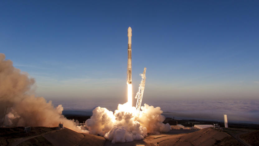
SpaceX cut its latest Falcon 9 stream because it didn't get a license
SpaceX had to cut off the Iridium Next mission's live feed early, and it might be because its Tesla launch got a bit too much attention. The private space giant raised questions (and may have given conspiracy theories plenty to chat about) when it suddenly stopped Falcon 9's live feed a few minutes into its journey. Its engineers said it was because SpaceX doesn't have permission from the National Oceanic and Atmospheric Administration to broadcast images captured by the cameras on the rocket's second stage.
NASA: 2017 was Earth’s second-warmest year since 1880
After careful analysis, NASA has declared that 2017 was the second-warmest year since the end of the 19th century. In a separate study using different analytical methods, National Oceanic and Atmospheric Administration (NOAA) ranked last year as the third-warmest in their records. But both agree that the globe has experience its five hottest years since 2010.
NASA satellite launch promises accurate week-long forecasts
NASA and NOAA know that multi-day weather forecasts can be crucial to tracking hurricanes and their aftermath, and they're about to significantly boost the reliability of those forecasts. They just launched JPSS-1 (Joint Polar Satellite System-1), the first of a series of NOAA satellites that should improve the accuracy of weather forecasts extending as long as a whole week. It includes five upgraded instruments (including an infrared imaging sensor and a microwave sounder) that can track weather-influencing factors with exacting detail, such as atmospheric temperature, clouds, ice cover, ocean colors and volcanic ash.

Climate change-denying House science chairman is retiring
Lamar Smith, the chairman of the US House of Representatives' Committee on Science, Space and Technology, has announced that he'll retire when his term ends next year. The Texas representative, an avid climate change denier, has been a controversial and, to many, an unwelcome head of the committee. During his tenure, he has published multiple opinion pieces on climate change, including some that claim it isn't a reality and others that state it's real but beneficial.

Forecast data model warns you of tornadoes hours in advance
Meteorologists usually only issue warnings for tornadoes when they're imminent, which gives you precious little time to take cover -- the American average is just 13 minutes. NOAA researchers may soon give you much more time to get to safety, though. They recently conducted the first practical test of a new model, Warn on Forecast, that gives you up to 3 hours' notice. The technique merges radar, satellite and surface data into a highly detailed prediction model. When you make frequent-enough predictions (every 15 to 20 minutes), you can tell when incoming weather patterns are very likely to trigger warnings.

Trump's quiet war on data begins
Two months into the Trump presidency, there's still a lot of uncertainty surrounding the new administration. One big area of concern is how the executive branch will deal with the vast amounts of data collected by the government. Federal agencies like NASA and EPA conduct countless studies crucial to understanding our impact on climate change. Labor Department surveys are vital to determining the economic health of the country. Will the administration manipulate data that contradicts its political views? Will information become a tool of oppression? Turns out there's a simpler, but potentially just as troublesome possibility: The White House could simply make it disappear.

NOAA's GOES-16 weather satellite takes its first solar images
NOAA's next-gen weather satellite GOES-16 beamed back photos of the Earth and the moon back in January, but that was just a taste of what it can do. Now, the Solar Ultraviolet Imager (SUVI) onboard the satellite has taken its first solar images, and NOAA has stitched them together to create a video that you can watch after the break. The images, taken on January 29th, show a large coronal hole in the sun's southern hemisphere. Coronal holes are parts of the solar surface where the corona (or outer atmosphere) looks darker than usual.
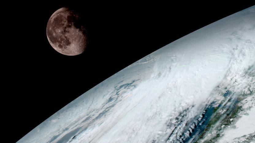
NOAA's next-gen weather satellite sends back its first images
NOAA's and NASA's GOES-R weather satellite has beamed back its first set of images, a couple of months after it left the planet. The spacecraft that's now known as GOES-16 used its Advanced Baseline Imager (ABI) instrument to capture photos, including the one you see above featuring the moon and the Earth's surface. GOES-16 was designed to be able to capture images at five times the speed and four times the resolution of older GOES satellites. It can take a photo of the whole planet every 15 minutes and of continental US every 5 minutes from its geostationary orbit 22,300 miles above Earth.


