traffic
Latest
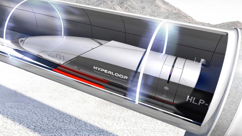
Apple's home city Cupertino wants a Hyperloop
Cupertino, the city that hosts Apple's gigantic "spaceship campus," said it's in preliminary talks with Hyperloop to bring the high speed train to town. "We are talking to Hyperloop to have a line," said councilor Barry Chang. "If this comes to a realization, it would only take five minutes from DeAnza College to downtown San Jose instead of a couple hours."
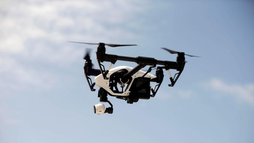
Ohio test uses drones to monitor highway traffic
Highway traffic monitoring is frequently... less than efficient. Fixed cameras can't catch problems beyond their immediate location, while aircraft are both costly and inevitably have to fly back to a distant base to refuel. These systems may soon get a robotic upgrade, though. Ohio State University is leading a pilot program that will use drones for roadway and traffic monitoring along a 35-mile highway stretch (the Smart Mobility Corridor) between Dublin and East Liberty. The dry run will see drones feed tracking data to the Ohio Department of Transportation's Traffic Management Center to complement data from existing systems. If there's a traffic-disrupting crash or a washed-out road, this might help spot it sooner.
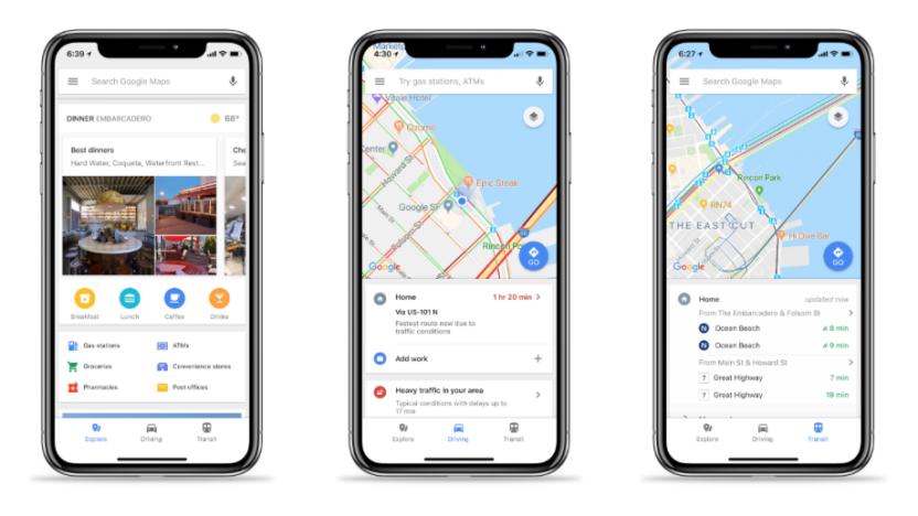
Google Maps for iOS adds easy access to traffic and transit info
Over a year ago, Google updated its Maps app for Android, making it easier for users to search for restaurants, check out nearby traffic and find public transit schedules. Today, that update is now available for iOS users. With the update, Google Maps users will see three options on the bottom of their screens -- explore, driving and transit.
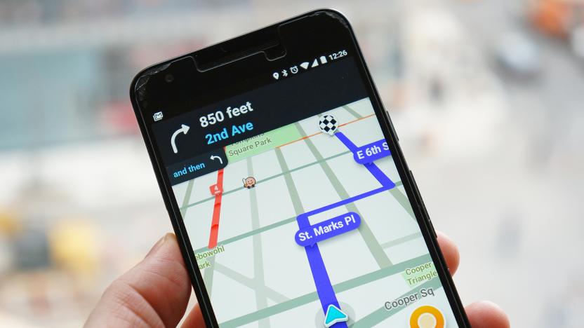
Waze's crowd-sourced traffic info comes to Ford Sync 3 cars
In 2016, Ford wisely decided to offer Apple's CarPlay and Android Auto on all its Sync 3 infotainment system-equipped 2017 vehicles, and owners are seeing more benefits from that at CES 2018. Ford announced that it now supports Waze's traffic and navigation app directly from your iPhone. After you plug it into any of the vehicle's USB ports, the app will appear on the Sync 3 touchscreen, letting you control it from there or use voice commands.

New Jersey town will close streets to fight navigation app traffic
It's no secret that some communities hate traffic-savvy navigation apps like Waze with a bitter passion. A congested highway can send legions of commuters down streets that clearly weren't meant for more than a handful of cars at any given time. And one town has apparently had enough. The New York Times has learned that Leonia, New Jersey will close 60 streets to everyone but residents and workers at peak driving periods (6AM to 10AM and 4PM to 9PM) from January 22nd onward. If you're using a nav app, the town may effectively cease to exist at rush hour.
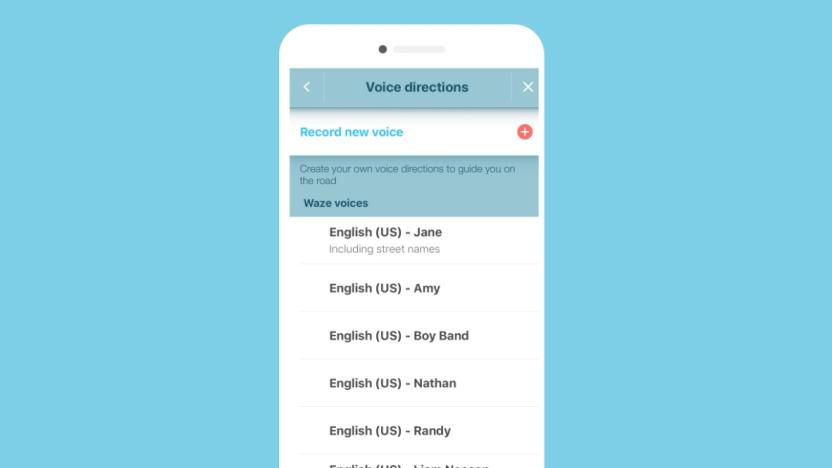
Waze adds Liam Neeson as its latest navigator
Liam Neeson seems like the kind of guy you'd want around in a crisis, and while the chances of him appearing when your pipes have burst or someone's fallen down the stairs are slim, you can now rely on him to help you navigate a killer traffic jam. Waze users in the US can enjoy Neeson's confident, dulcet tones until January 14, thanks to a promotion for his upcoming flick The Commuter. Just make the switch through voice directions, under settings, in the app. This isn't the first time Waze has introduced celebrity voices to its services, but having Neeson ride shotgun has got to be less stressful than Arnie.
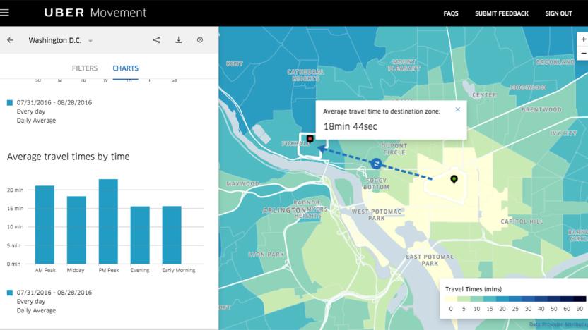
Uber Movement's traffic data is now available to the public
Back in January, Uber announced that it's giving urban planners access to a website with traffic data of their cities. Now that website is out of beta, and anybody can access it anytime. The Uber Movement website can show you how long it takes to get from one part of a city to another based on the day of the week and the time of day. People like you and me can consult it for realistic travel times, since its data came from actual Uber trips. However, its real purpose is to help city officials and planners figure out how to improve their transit systems.
Audi, BMW and Mercedes cars will share live traffic jam data
It's not too hard to find real-time traffic data, but it's usually specific to one car make. Wouldn't it be great if cars of all brands could regularly coordinate? They're not quite there yet, but they're getting closer. Here has unveiled a Real-Time Traffic service that has cars from Audi, BMW and Mercedes-Benz (all co-owners of Here) sharing their live sensor data to provide more accurate traffic alerts than you'd get from external probes alone. It's particularly helpful on 'arterial' roads, Here says. And more than 30 of the 60-plus countries covered by the service can also take advantage of safety warnings based on sensor data you expect from incidents, such as hard braking to avoid a crash.
AI will take control of Milton Keynes traffic lights next year
Whatever sins you've committed in life, being sandwiched in traffic in Milton Keynes is a punishment no one rightfully deserves. This modern penance should become less gruelling from autumn next year, when Milton Keynes is expected to become the first UK city (or is it a town?) to switch on an AI-powered traffic management system. A company called Vivacity Labs, with a little help from the public purse, will begin installing 2,500 cameras into traffic lights around the city this September. When live, the system will monitor major junctions and car parking spaces in a 50 square mile zone, and be tasked primarily with tackling congestion.

A single autonomous car could greatly reduce man-made traffic
Traffic. We all hate it, but what can honestly be done to significantly reduce it? Well, according to an experiment conducted by the university of Illinois, simply introducing a few self-driving cars to roads could be the answer. Conducting experiments in Tucson, Arizona the team discovered that even adding a single autonomous vehicle to the roads can massively reduce traffic. They programmed a self-driving car to loop a track continuously and then added 20 other human-driven cars to the mix. While humans somehow naturally create stop-and-go traffic even without lane changes or other disruptions, thanks to the robotic racer, both traffic and fuel consumption were reduced by 40 percent.
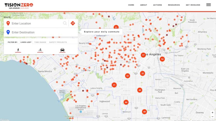
LA fights soaring pedestrian deaths with an interactive map
Open data can be an incredibly powerful tool, but it still requires context and people to actually pay attention to the information for it to be valuable. Los Angeles has discovered this the hard way. Its Vision Zero initiative aims to eliminate traffic deaths by 2025, but compared to other cities with similar programs, LA is coming up short in terms of results. After the program's first full year (2016), fatalities rose by some 43 percent according to the Los Angeles Times. There are a number of reasons for this, including more pedestrian and bicycle traffic, distracted driving and driving under the influence. To combat the rising number, the city looked to data as a means of discerning the most fatal roadways.
Waze's traffic data could help emergency services save lives
Soon, Waze data will not only help drivers avoid accidents, but help emergency responders identify them as they happen. The Google-owned navigation service has partnered with the European Emergency Number Association (EENA) to anonymously share data that will help police, ambulance and fire services detect and respond to incidents in real-time, potentially saving lives in the process.
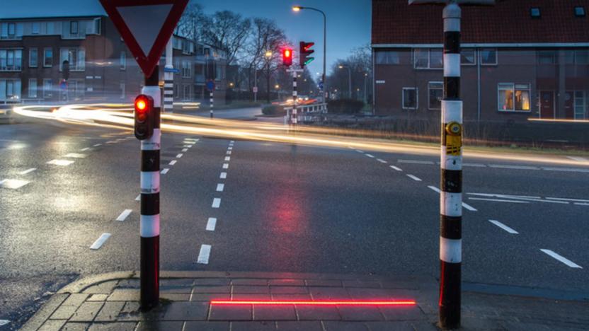
Dutch town adds 'Lightlines' to alert distracted pedestrians
A city in the Netherlands is the latest to give distracted smartphone users an extra heads-up in the crosswalk. A pilot project in the city of Bodegraven called +Lightlines (or +Lichtlijn in Dutch) is the latest take on in-ground sidewalk crossing signals and it puts a bright, laser-like strip of green and red LEDs right where multi-tasking pedestrians can see them.

German cars will share real-time data to help you find parking
However smart your car might be, there's only so much it can tell you by itself. Wouldn't it be nice if cars regularly shared helpful driving info beyond what you offer in mobile apps? Here thinks so. It's launching services that will have cars automatically sharing real-time data to improve commutes for everyone. Vehicles (starting with those from Here owners Audi, BMW and Mercedes-Benz) will use their sensors and cameras to offer details on free parking spaces, traffic conditions, and road hazards. You'd know that a parking spot has opened up, or that heavy rain is forcing drivers ahead to slow down.

Audi cars will start talking to city traffic systems this fall
If you've ever been stuck at a red light that seems to last an eternity, you'll be happy to know that Audi announced that it's going to start work with municipalities to tell its cars when a light is about to turn green. The automaker says this is the first step in a Vehicle to Infrastructure (V2I) partnership with cities that will be launching this fall.

London buses to show live traffic updates in rear windows
Over time, transport authorities have improved how they share important road travel news. Roadside signs can give a driver an important heads-up during journeys and apps can notify travellers before they've even left the house. As part of a new trial, Transport for London (TfL) wants to reduce the temptation for motorists to look at their phones while on the move by displaying live traffic information on the back of London's buses.
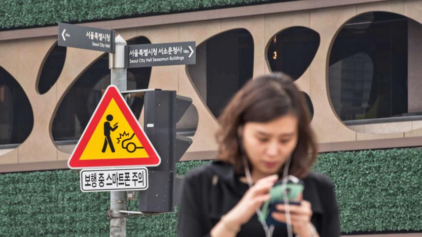
South Korea hopes traffic signs will cut phone distractions
Cities have tried a number of exotic solutions to get phone-toting pedestrians to focus on where they're going (or at least, out of the way). However, Seoul thinks there's a simpler answer: traffic signs. The South Korean capital is testing signs that warn smartphone owners in five accident-prone areas (such as City Hall or Gangnam Station) about the perils of distracted walking. In theory, those periodic reminders will have you looking up more often and spare you from smacking into a car.

Uber shows off its first self-driving car
Uber's foray into the world of self-driving vehicles will become a lot more visible in the coming weeks after the company confirmed its first autonomous car will officially hit the streets of Pittsburgh. The prototype -- a hybrid Ford Fusion -- will assist the company in collecting mapping data while putting its self-driving capabilities to the test. Uber's Advanced Technologies Center (ATC), which is headquartered in the city, has equipped the car with a variety of sensors including radar, laser scanner and high-resolution cameras, but a human rider will be present at all times.

Waze begins testing new carpooling service in the Bay Area
Google-owned navigation app Waze is bringing their carpool pilot program stateside. The company will test the new Waze Rider app with 25,000 employees at select Bay Area companies who will be able to get a ride to work with the over 700,000 local drivers using Waze.

Inrix Traffic app uses AI to learn your driving habits
It's been awhile since we've heard from Inrix, the company that uses OpenStreetMap and its own traffic analysis to guide you via GPS. It also supplies connected car tech to Lexus, Mercedes-Benz, Porsche and other automakers. The company just completely redesigned its iOS and Android Traffic apps, adding machine learning features, calendar integration and more. While there are tons of such apps to choose from, Inrix's app is geared toward frequent drivers who do routine trips where they often battle traffic.


