trafficdata
Latest
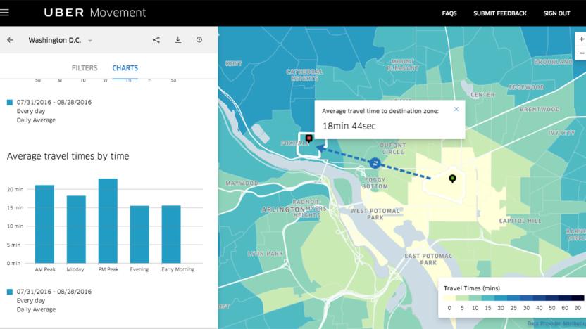
Uber Movement's traffic data is now available to the public
Back in January, Uber announced that it's giving urban planners access to a website with traffic data of their cities. Now that website is out of beta, and anybody can access it anytime. The Uber Movement website can show you how long it takes to get from one part of a city to another based on the day of the week and the time of day. People like you and me can consult it for realistic travel times, since its data came from actual Uber trips. However, its real purpose is to help city officials and planners figure out how to improve their transit systems.

Verizon offering up anonymous data to improve real-time traffic information
AirSage has been working on the whole cellular data-traffic flow interconnection thing for a while now, and the company has just landed itself a whale of a partner for collecting that data: Verizon. It's said that the integration of anonymous cellular signaling data from Verizon's network will quadruple the number of messages AirSage is receiving, covering 200,000 miles of roadway across the country with improved information on just how screwed you are by that lane-widening project right now. The companies aren't saying how long it'll take to fully integrate the additional data, so in the meantime, just go ahead and give yourself the extra 15 minutes to get to work -- something tells us you'll need it.

Traffic reports to derive from cellphone location data
Intelligent roadways and traffic monitoring systems have been available (albeit not always entirely accurate) for some time now, but if IntelliOne and AirSage have their way, finding out about real-time roadblocks (and voyeurism lawsuits) could become a more fleshed-out reality. The firms are looking to utilize that oh-so-telling "anonymous" location data from each traveler's cellphone to pinpoint locations and overlay that information with maps. If wireless companies open up that data at a rate of "twice per second" while users are conversing and "once every 30 seconds" when not on a call, the entrepreneurial duo hopes to offer more detailed information and pragmatic advice than "radar, helicopters or cameras" currently do. While keeping a keen eye on traffic developments certainly has its benefits, the real issue here is privacy (or the lack thereof); while government uses have already been in place, carriers are (understandably) more hesitant to turn over consumer data for locating purposes. While the service would be marketed free of charge to wireless carriers, interested customers not enraged by such intrusions could purchase the data for a monthly fee, and if all goes as planned, the Tampa pilot that is currently ongoing will lead to "40 other markets" being invaded by this time next year.[Via The Wireless Report]


