geofencing
Latest

Bird will test sensors that prevent riding on sidewalks
Collaborating with a firm called U-blox, the company has developed a custom multi-sensor and GPS module it says is far more accurate than other solutions at detecting when someone drives a scooter onto a sidewalk.
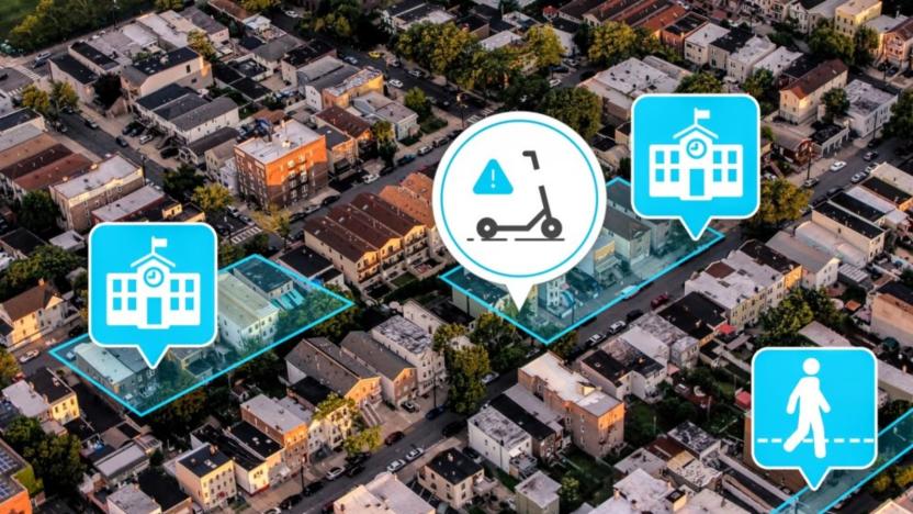
Bird tests geofencing system to slow scooters in pedestrian-heavy areas
Bird has introduced Community Safety Zones, a feature that uses geofencing to cap the speeds of its scooters in certain areas automatically.
Minneapolis police used Google location data to find George Floyd protesters
Minneapolis police served Google geofence warrants to identify George Floyd protesters, raising questions about privacy and innocent bystanders.

Google location data led police to investigate an innocent cyclist
Those concerns about police indiscriminately collecting Google location data have some grounding in the real world. NBC News has revealed that police inadvertently made a suspect of an innocent cyclist, Gainesville, Florida resident Zachary McCoy, after using a geofence warrant (collecting all location data around the scene of a crime) to look for leads in a March 2019 burglary. McCoy had been using RunKeeper to track his biking, and had passed by the victim's house three times in the space of an hour -- enough to raise eyebrows among investigators looking for suspicious info.
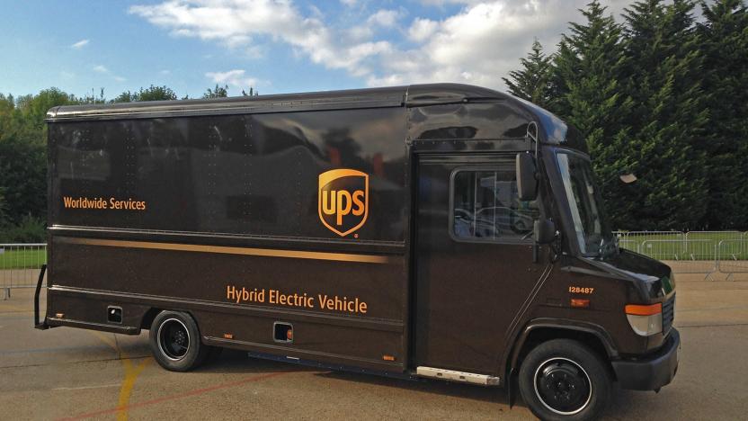
UPS hybrid trucks automatically switch to EV mode in cities
UPS has unveiled hybrid electric trucks that not only quadruple the range of previous vehicles, but automatically switch to battery-only mode in UK cities and clean-air zones. On top of that, the trucks (built by EV startup Tevva) will have the same cargo capacity as like-sized diesel trucks. The aim, said UPS and Tevva, is to get ready for the UK's strict "Net Zero" laws that will completely cut CO2 emissions by the year 2050.

Volvo will limit cars to 112MPH as it explores speed-restricting tech
Volvo is nothing if not safety-conscious, and it's making clear that speed is one of its greatest concerns. The Swedish brand is limiting the top speed on all its cars to 112MPH starting with the 2021 model year. Safety technology and city infrastructure isn't enough to prevent injuries at high speeds, Volvo said. The lower limits would both address this gap and encourage better driver behavior. On top of this, it hinted at using technology to restrict speeds.

DJI updates geofencing system in Europe after Gatwick airport scare
Drone manufacturer DJI announced today that it is updating the geofencing system it uses in Europe to prevent drone pilots from flying the unmanned aircraft in places where they don't belong. The updated Geospatial Environment Online (GEO) 2.0 system will be introduced in 19 European countries and is expected to roll out over the course of this month.

Instagram may tidy up captions by hiding hashtags
Instagram appears to be testing a way to add hashtags to a post without having to include them in the caption itself. App researcher Jane Manchun Wong spotted the feature and tweeted a screenshot of an updated interface. In the image, you can see a new "Add Hashtags" section and a screen where you can search for and select hashtags to add to your post. Wong added that it appears, as of now, there is no limit to how many hashtags can be added with the new feature.
UK drone rules will require you to take safety tests
US officials might be easing up on drone regulations, but their UK counterparts are pushing forward. The British government has instituted rules that require you to not only register any robotic aircraft weighing over 250g (0.55lbs), but to take a "safety awareness" test to prove you understand the drone code. Regulators hope that this will lead to fewer drones flying over airports and otherwise causing havoc in British skies. Not that they're taking any chances -- the UK is also planning wider use of geofencing to prevent drones from flying into dangerous airspace.

DJI throttles its drones unless you register them (updated)
You might not have to register your drones through the Federal Aviation Administration anymore, but if your flyer of choice is a DJI model, you'll have to activate it online, or take a hit in flight range and functionality. The company is adding a new application activation process, tied to a firmware update for its family of drones. It'll come into effect at the end of this week, and is aimed at ensuring pilots use "the correct set of geospatial information and flight functions for your aircraft", determined by your location and user profile. The aim should be fewer crashes, and hopefully less broken DJI drones.

DJI makes it easier to keep your drone out of no-fly zones
DJI's Geospatial Environment Online (GEO) software already kept pilots from flying its drones in "sensitive areas" and now the setup is getting a lot more useful. The UAV maker is making improvements to the system inside of its Go app that's used to control Phantom and Inspire drones. By doing so, DJI gives pilots easy access to its geofencing system that keeps airports, prisons and power plants permanently locked down in addition to temporary restrictions around special events like stadiums and "national security events."

Nest's co-founder is releasing a smart go-kart for kids
Nest co-creator Tony Fadell isn't focused solely on making intelligent thermostats and smoke detectors. He recently unveiled Actev Motors, a company whose inaugural Arrow Smart-Kart promises to give kids a taste of what smart cars are like. The electric go-kart includes GPS, a and WiFi to keep junior drivers safe. Parents using a mobile app can geofence the kart's driving area, limit the top speed or hit a stop button in an emergency. In other words, even younger kids (5- to 9-year-olds are the main targets) can motor around without getting in over their heads. There's also a proximity sensor to automatically prevent accidents.

Drone-maker DJI starts testing GPS-based flight restrictions
After some rather high-profile incidents of drones ending up where they don't belong, manufacturers rushed to find a solution. Otherwise they might have found themselves on the wrong side of some very tough legislation. DJI just launched its solution, Geospatial Environment Online or GEO. It's a geofencing system that keeps your drone from taking off in restricted areas... unless you have a verified DJI account and a credit card on file that is. See, while you can't just go out and fly through Washington DC willy nilly, you can promise to be financially accountable and DJI will turn off the restrictions temporarily.Right now GEO is in beta, so you'll have to either request access to the app on iOS by emailing flysafe@dji.com or you can download the Android APK directly. You'll also need to update the firmware on your drone. If you're not the type to mess with potentially unstable software, don't worry, the final version shouldn't be too far behind.

DJI's drone safety system has you signing up to fly in some areas
DJI is understandably nervous about where you fly its drones given that one owner trespassed on White House grounds, and it's rolling out a new geofencing system to make sure that these kinds of incidents don't happen again -- just hours after rivals 3DR did the same. Its Geospatial Environment Online service gives you updated info on where you're allowed to fly drones, including time-sensitive restrictions. You can't fly over prisons, for instance, and you may face a ban when there's a raging forest fire. However, it also has a unique way of handling exceptions: as long as you're willing to register with a payment card or phone number, you can fly in some restricted areas. In theory, this lets you enjoy your drone in more places while holding you accountable if you screw up.

"Dances with iBeacons": Testing Radius Networks RadBeacons
Although I'm not a developer by any stretch of the imagination, I find the concept of iBeacons to be fascinating. The idea of low-power Bluetooth beacons that can coax apps into providing information about something that's near them is very cool, and a while back I wrote about some apps available from Radius Networks that provided a way to start playing with the technology without investing in any physical iBeacons. Well, Radius Networks is now rolling out the hardware in the form of what it calls RadBeacons, and I recently had a chance to try out two models and configure them with their own unique names. The US$29 RadBeacon USB (left in image at the top of this post) is a tiny USB dongle that can be plugged into any standard USB adapter for power, while the $39 RadBeacon Tag (the white tag in the middle of the top image) is a battery-powered tag that is perfect for those situations where power may be an issue. Both the devices work with apps from Radius Networks as well as any other apps that are aware of iBeacons. The free RadBeacon app (universal, optimized for iPhone 5) is used to configure RadBeacon proximity beacons. You can scan for configurable RadBeacons with a single swipe gesture, and each discovered beacon displays its name, model, and ID. Tapping on a discovered beacon shows its name and advertised UUID identifier, major identifier, minor identifier, power value, rate setting, and transmit power setting. To update any of those settings, you just enter a valid PIN (which you can also apply), then change the settings and hit Apply. There's also a way to calibrate the measured power of the beacon by holding it at a set distance away, then letting it go through a calibration process. Once calibrated, you can measure the proximity of the beacon with the app as well. When everything is set up the way you want it, it's possible to lock the device so that third parties can't reconfigure it. The Locate for iBeacon app (free, universal, optimized for iPhone 5) is what you can use to locate those pesky RadBeacons (and other iBeacons). One thing I found odd about this app is that although I had set new names for a RadBeacon USB and a RadBeacon Tag, they still showed up in Locate for iBeacon as generic beacons with a name of Radius Networks 2F234454. Once you find a beacon, the distance to it is displayed. And for some inexplicable reason, the Locate app also includes a way to configure and calibrate the RadBeacons ... so why have two different apps? For tagging movable items with an iBeacon, the RadBeacon Tag works best. It's battery powered, and has a hole in it through which something like a cable tie or wire can be passed to attach the tag to something. The RadBeacon app showed all of the regular info for the tag, adding the battery level as well. The batteries are replaceable. What I was surprised with is just how accurate the proximity readings are on a properly calibrated beacon. This really speaks to how it will be possible for stores, museums and other venues to notify people within a short distance of a beacon of a product, piece of art, or whatever else you want them to look at in your app. One thought I had while trying out the RadBeacons was that I'd love to see Geocaching figure out a way to work these into "the game." In other words, a geocacher could use GPS to get into the vicinity of a cache, then -- if they've been unsuccessful finding the cache by traditional means -- be able to ask for an iBeacon notification when they're right near the cache. Likewise, curious would-be iBeacon fans can do things like purchase a few RadBeacons, then use apps like Proximitask (free) or the recently-updated Launch Center Pro ($4.99) to set up reminders that go off with you arrive at or leave a specific location. The latter app can even trigger IFTTT recipes, which opens up a whole new world of location-based automation. Conclusion While the Radius Networks apps aren't exactly perfect at this point in time, developers and other individuals interested in trying out iBeacon-based ideas can now do so without spending a lot of money. I highly recommend both the RadBeacon USB and RadBeacon Tag for experimentation, and would love to hear from TUAW readers who are coming up with innovative iBeacon solutions. Rating: 4 stars out of 4 stars possible

MacBeacon and Locate for iBeacon: An inexpensive way for developers to design and test iBeacons
iBeacons are a hot topic and getting hotter. It seems like we're hearing a lot about retailers and others who are chomping at the bit to use the short-range, highly focused location technology for things as varied as in-building directions or targeted advertising. But how are developers able to start creating iBeacon-enabled apps without having one of the Bluetooth devices on hand? That's where some tools from Washington, DC-based Radius Networks can help out. The company recently announced MacBeacon (US$9.99), which allows any Bluetooth 4.0 (Bluetooth Low Energy) equipped Mac to be set up as a test iBeacon. If a developer is just getting his or her feet wet in the iBeacon world, the company even has a free iOS app called Locate for iBeacon available. MacBeacon allows developers to create beacon profiles that provide full iBeacon functionality. For developers who want to test iBeacon-enabled apps, it's a great way to see how the apps react to proximity to iBeacons. Devs can give the iBeacon a name for labeling purposes (it's not broadcasted by the beacon), generate a UUID, set group identifiers and adjust the beacon's power level. A full help page provides both an introduction to iBeacons as well as assistance in using the app. The Locate for iBeacon app does exactly what the name implies -- it locates iBeacons. But it does more than that, providing distance measurements between the iOS device and the iBeacon, a way to calibrate the iBeacon and also a way to turn an iOS device into an iBeacon itself. A developer could theoretically just use the Locate for iBeacon app for testing purposes. Radius Networks also has iBeacon hardware development kits available (US$99.99 to $149.99). Based on the popular Raspberry Pi single-board PC, these kits feature one or two Bluetooth LE transmitters and come with iBeacon software that works with Apple's iBeacon SDK. The company has developer tools available, including the Message Radius platform (for pushing notifications to devices when they're within a certain range of an iBeacon) and a Proximity Kit API for setting up localized geofences. TUAW reported earlier this week on how retailer Macy's and shopping app Shopkick teamed up to use iBeacon technology in a few flagship stores. With tools like those from Radius Networks making it easier for developers to implement the technology, you can look forward to seeing iBeacons everywhere you go.

Google outs new Maps and Location APIs: geofencing and low-power location services
Maps is one of the most useful features in Android, and today at Google I/O 2013, Mountain View announced a trio of new location services APIs to help devs to better leverage that strength. Fused Location Provider is the first, and it brings faster, more accurate location signals and delivers a low-power location mode that sips less than 1 percent of your battery while in use. Next is Geofencing, which will allow devs to set up to 100 location-based triggers for app events. The third API is called Activity Recognition, which uses accelerometer data and machine learning to figure out when you're walking, cycling or driving.

Verizon's Vehicle Diagnostics by Delphi now monitoring your car for $250
Who'd have thought we'd be happy to see an unassuming black box? Delphi and Verizon managed to whet our interest with their Vehicle Diagnostics kit and service at CES, and our curiosity is renewed now that the monitoring combo is available for drivers. The finished product costs a fairly steep $250 for the Delphi adapter, although it does deliver two years of free service and costs a contract-free $5 per month afterwards. Shelling out brings the promised remote troubleshooting and notifications, including alerts for any performance problems and warnings for any geofencing violations. If you're willing to pair an Android or iOS phone with the kit over Bluetooth, you can also use the smart device in place of your keys -- temporarily, we hope. Vehicle Diagnostics should work with most cars made from 1996 onward, but do some homework before any outlay: at least a few cars miss out on the full diagnostic suite, which might dampen dreams of a connected car utopia.

RE/MAX real estate agents to carry Passbook business cards on their iPhones
We've seen some creative use cases for Passbook in iOS 6. Modernizing the dreaded business card exchange is still fresh, though, and that's where the real estate agents at RE/MAX come into play. Using a platform from Vizibility, the realtor is reportedly the first company rolling out a large-scale, Passbook-based method that lets 4,500 of its staff share their basic details, contact files and social networks from their iPhones. Profiles won't just be inert listings, either. Geofencing can limit the lock screen shortcut to an open house or the office, while cards can include company directories and update contacts over time. NFC transfers and QR codes are available for those who can rely on short-range wireless or still have to dish out traditional paper stock. Vizibility's Passbook approach won't guarantee a sale for a cramped house -- but it might keep a good bargain from being lost in the business card shuffle.

Apple starts offering Passbook-enabled gift cards, may save our hides in holiday shopping
Gift cards often get a bad rap as the last resort in holiday shopping, what we supposedly get only when all hope of a carefully considered present has gone out the window. Apple isn't quite so cyncial, and it may have injected new life into gift giving now that it has switched on buying gift cards through the recently updated Apple Store iOS app as of this weekend. Pick a color and a card value -- up to $2,000, if someone's been good enough to earn a MacBook Pro -- and the resulting email lets iOS 6-touting recipients load the card into Passbook. Besides saving some plastic, the Passbook entry adds some worth through geofencing that reminds recipients to splurge if they're near one of Apple's steel-and-glass stores. All told, the card may be more than welcome by iPhone fans and save the ignominy of a last-minute rush to the store. Just make sure the recipient doesn't mind going without a physical gift on the big day -- it wouldn't be right to drain all the romanticism out of a special occasion.


