geolocation
Latest
Artist creates traffic jams in Google Maps with a wagon full of phones
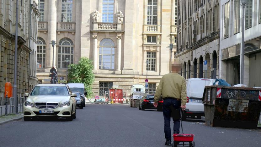
We tend to think of Google Maps as an indispensable tool that is rarely wrong, but an artist from Germany named Simon Weckert found a humourous way to game the app. Using a wagon loaded with 99 second-hand smartphones, he was able to "hack" Maps to create virtual traffic jams throughout Berlin.

New York City bill could make selling phone location data illegal
New York City could become the first city in the country to ban the sale of geolocation data to third parties. A bill introduced today would make it illegal for cellphone and mobile app companies to sell location data collected in the city. It would impose hefty fines -- up to $10,000 per day, per user for multiple violations -- and it would give users the right to sue companies that share their data without explicit permission.

Louis Vuitton is making a luggage tracker
A smartphone app and recent FCC filing strongly hints that Louis Vuitton has a new tech product on the way: A luggage tracker that pairs with particular bags sold by the fashion company. Sources tell Engadget that it will be the first such device to work internationally, but there has been no official confirmation yet.

Snapchat just made tagging places a lot more useful
More and more places are getting their own Snapchat location filters, but what good are they? Well, now they link to further information about where your pals are sending evaporating updates from. The ephemeral photo app is calling them Context Cards. The video filled with very attractive twentysomethings below shows restaurant reviews from TripAdvisor, destination info for driving your own car or taking Lyft or Uber and will add your location to a map, Foursquare style. It looks like you can even make hotel reservations without leaving Snapchat, too -- all based on the location filter you pick.

Walking ‘Silent Streets’ makes for a sinister but short adventure
My friends, who knew of my uncharacteristic love for Pokémon Go, suggested that I try Silent Streets. It's a brand-new mobile game that combines the same mechanics of augmented reality and walking that I enjoy so much. There's no magical critter-catching going in Silent Streets. It's a Victorian gothic detective story that sees you roaming your local area to solve a murder -- one that had me walking around trying to find "The Boy With the Flower Skin."

Google neural network tells you where photos were taken
It's easy to identify where a photo was taken if there's an obvious landmark, but what about landscapes and street scenes where there are no dead giveaways? Google believes artificial intelligence could help. It just took the wraps off of PlaNet, a neural network that relies on image recognition technology to locate photos. The code looks for telltale visual cues such as building styles, languages and plant life, and matches those against a database of 126 million geotagged photos organized into 26,000 grids. It could tell that you took a photo in Brazil based on the lush vegetation and Portuguese signs, for instance. It can even guess the locations of indoor photos by using other, more recognizable images from the album as a starting point.

Tiny geolocators track birds flying 1,600 miles across the Atlantic
It's easy to prove that big birds like gulls will cross oceans when they migrate, but tiny birds are another matter -- the trackers you need are usually enormous in comparison. The Vermont Center for Ecostudies wasn't daunted, though. It successfully tested extra-small geolocators on blackpoll warblers, migratory songbirds that are too small and light (0.4oz) to shoulder previous sensors. The newer device weighs just 0.02oz, and is no bigger than a dime. As you can see above, it was more of a minor inconvenience than a heavy burden.

Heyday: A wonderful, well-designed personal journal app for iPhone
As I get older – and I'm already older than dirt compared to most of my fellow TUAW-ites – I find that it's more important to me to capture memories of what's going on in my life. I've been an avid journalist (one who writes a personal journal) since the early 2000s, and Day One is one of my favorite apps both on iOS and OS X. But I've often wished for a way that my daily travels and photos could be automatically captured for posterity. That's the idea behind Heyday, an iPhone app that's billed as a "Smart Photo Organizer and Collage Journal/Diary". The app was first reviewed on TUAW back in January 2014 by Kelly Hodgkins; I thought I'd take a look at the app again. Now that app subtitle is a long description, but it describes some of the functions of Heyday quite well. When you first launch the app, you're asked to create a free account or log in via Facebook. Heyday then grabs images (with your permission) from your Photo Library to provide a history of things that you've done in the past... It also begins to track your location (with your permission, of course). When Heyday notices that you've been in a location for a bit of time, it notes that in the app's timeline. Heyday is a good-looking app. From the moment you launch it, you're pulling up memories of things that have gone on in your past. The top of the launch screen is a ever-changing slideshow (done with filters and the ever-popular Ken Burns effect) of images from your photo library, while below that is a daily timeline of where you've been. If you have more than one image for a particular day or stop at a location, they're automatically placed into a collage -- with a tap, you can drag the images into another collage format if you like. The slideshow effect may transfix you. I spent about thirty minutes last night just looking at the app's slideshow, remembering where I was when I had taken some of the images. They're tagged with the date as well as with the location as taken from geolocation information stored in the EXIF data for the photos. It's possible to turn off the automatic photo filters, and easy to drop a passcode lock on the app if you're concerned about others seeing what you've been up to. You can also have the app remind you to add photos or location entries once a day - I think it's easier to just let the app do its job. Editing your entries is a snap, too. It's possible to "fix" a mistaken location, add your own notes, or take additional features to add to an entry. If you decide that you'd like to share a moment with friends, just tap on the images and you can send it out via Facebook, Instagram, Twitter, iMessage, or email. Each collage that Heyday produces can also be saved to your photo library, so if you really like the way that it filtered and laid out the images, you can keep 'em for posterity. Is there anything I'd like to see added to Heyday? Yes - I would love it if the developer got together with the Day One team so that each day's Heyday memories could be automatically added to my Day One entries, which tend to be a daily written discussion of what's going on. Each app is amazing; the two together would be the perfect personal journaling duo. Kelly had also worried about the longevity of her entries, and I think that being able to move the information from Heyday to Day One or at least be able to export it as a large PDF file would be the perfect solution. Heyday's free, so go out and get it. I hope you like it as much as I do.

Warblr can identify that bird just by hearing its song
Technology can be pretty wonderful sometimes. Case in point: Warblr, an app that uses sound recognition tech and your phone's GPS signal to identify birdsongs. The application first pinpoints where you are (it'll debut in the United Kingdom), and narrows the results by what types of fowl are common to the area, according to its Kickstarter page. Then, after making the ID, it presents the most likely suspects. Pretty simple, yeah? The folks behind the app say that one of the intentions is to add geo-tracking to, well, track what species are being found where -- useful for the likes of zoologists and ecologists to monitor migration patterns, for one.

'Whisper' app accused of not hiding whistleblowers
Whisper lets you share secrets without the fear of it getting traced back to you. At least that's the pitch. Now, according to a Guardian report, the service is tracking the location of users that didn't want to be tracked. The report, which deep dives on several issues regarding user privacy and security, adds that Whisper is apparently also sharing info with the US Department of Defense and is retaining posts and user data in a searchable database. Responding to the claims, Editor-in-chief Neetzan Zimmerman says that Whisper "neither receive(s) nor store(s) geographical coordinates" from users who opt out of geolocation services. "User IP addresses may allow (a) very coarse location to be determined to the city, state, or country level."

Cortana now taps into Foursquare to give you recommendations for lunch
It turns out that Microsoft had bigger plans for Foursquare than just search and maps for Bing. The check-in service is now accessible by Redmond's digital assistant, Cortana, as spotted on Reddit by Neowin. The addition apparently makes for customizable, local recommendations based on your whereabouts, and presumably, your account history too. As Winbeta notes, because the Cortana updates take place on Microsoft's servers, you won't need to download a software patch to take advantage of them either. Whether the blue helper will get to love bees, though, is up to her creators. Update: Microsoft's Bing Blog has confirmed the change and revealed how to turn it on: "pull up Cortana's notebook go to Interests, look for "best nearby" and then toggle to ON."

The TUAW Daily Update Podcast for June 5, 2014
It's the TUAW Daily Update, your source for Apple news in a convenient audio format. You'll get some the top Apple stories of the day in three to five minutes for a quick review of what's happening in the Apple world. You can listen to today's Apple stories by clicking the player at the top of the page. The Daily Update has been moved to a new podcast host in the past few days. Current listeners should delete the old podcast subscription and subscribe to the new feed in the iTunes Store here.
.jpg.cf.jpg)
New Cloak app helps you hide from 'that guy'
There are a plethora of geo-location-based apps that make it incredibly convenient to do friendly things, like chat with nearby peers about local hotspots or meet up with a coworker on the fly. A new iOS app called Cloak, however, utilizes services from Foursquare and Instagram for a more anti-social purpose. The brainchild of Brian Moore and former Buzzfeed creative director Chris Baker, Cloak identifies the location of friends (read: those you'd rather not bump into) based upon their latest check-in. While perusing the map, you can choose to "flag" certain undesirables, like exes or annoying third-wheels, to be notified when they wander within a preset distance of your personal bubble. Or you could, ya know, skip town altogether just to be safe.
NSA collecting 5 billion cellphone location records per day
Hey everyone, the government's tracking you. Quelle surprise. In what has to be one of the least shocking pieces of news to come from the Edward Snowden leaks, The Washington Post is reporting that the National Security Agency has been gathering surveillance data on foreign cellphone users' whereabouts globally, with some Americans potentially caught in the net. The database, which collects about 5 billion records per day, is so vast that not even the NSA has the proper tools to sift through it all. That's not to say the agency hasn't been able to make "good" use of it with analytics programs, though. One such program, ominously labeled Co-Traveler, allows the NSA to determine "behaviorally relevant relationships" based on data from signals intelligence activity designators (or sigads for short) located around the world, including one codenamed "Stormbrew." That's a lot of jargon for what are essentially data hubs that collect geolocation information down to the cell tower level. Co-Traveler can locate targets of interest based on cellphone users moving in tandem, even if they're unknown threats -- frequent meetups with an existing suspect could reveal a close associate, for instance. As we've come to expect by now, both the NSA and the Office of the Director for National Intelligence argue that this location-based surveillance is legal. Agency representatives tell the Post that the collection system doesn't purposefully track Americans. However, the NSA also says it can't determine how many US residents get swept up in these location scans; there are concerns that it's following targets protected by Fourth Amendment search rights. Jon Fingas contributed to this report.

Mozilla starts crowdsourcing data to help devices find your location without GPS
Mozilla's got a full plate between browsers, Firefox OS and a mess of other projects, but that hasn't stopped it from starting a new initiative. The software community has set up the experimental Mozilla Location Service to collect crowdsourced geolocation data from public WiFi networks and cellular towers. According to the outfit, devices with weak or non-existent GPS capabilities will be able to determine where they're at with the help of the service. Anyone interested in contributing will need to download the MozStumbler app for Android, walk around and upload data. Mozilla's aware you'd be handing over personal location info by using the application, so it's vowed to improve privacy all around. There's no word of an iOS counterpart just yet, so contributors will be limited to Mountain View's OS for the time being.

FiLIP is an electronic leash for your kids' wrists and it's coming to AT&T
Electronic leashes for the 21st century kid? You knew this sort of thing was inevitable. FiLIP, a smartwatch and 'locator' for kids that takes helicopter parenting to an excessive level, is heading to AT&T's lineup as an exclusive. As you'd expect from a device targeted to tagging kids, the FiLIP doesn't come close to the functionality of something more grown-up like the Galaxy Gear. It's mainly intended to be a colorful way to keep tabs on your kids, whitelist who can call their wrists, see their current location (via GPS, WiFi and cell tower triangulation), send texts and set safe zone parameters, so you know when you're child is literally out-of-bounds. It's the stuff of overprotective mothers' dreams and, at some point in the "coming months," those needy momagers will be able to pick it up for an undisclosed price with requisite data plan at AT&T. Basically, this is just AT&T giving that neurotic demo a heads-up -- you know, plenty of time to add FiLIP to the ever-increasing to-do list. If you thought you had it bad as a kid, imagine what life's going to be like for this upcoming generation.

Skyhook sues Google for patent infringement... again
Last time Google found itself in court proceedings opposite Skyhook, it was facing anticompetitive and IP legal claims for forcing Android OEMs to use Google's location services. Yesterday, Skyhook filed a new complaint alleging that Google is infringing nine of its patents. FOSS Patents reports that the IP in question is, like last time, all about geolocation technology. The patents cover various aspects of a WLAN-based positioning system, and all but one of them were granted after the prior lawsuit, hence the new legal action. We've yet to hear Google's side of the story, but you can take a peek at Skyhook's airing of grievances at the source below.

Daily iPhone App: GPS4CAM adds geolocation to your DSLR photos
While many photography applications like iPhoto and Aperture can make use of GPS information in terms of grouping pictures by location, there aren't a lot of cameras that have built-in GPS receivers. Of course, that's not a problem if you do all or most of your photography with an iPhone, since all photos taken with the Camera app are automatically stamped with the latitude and longitude of the spot where the image was captured. But what do photographers do when taking photos with their favorite DSLR or compact camera that doesn't have a GPS receiver? That's where GPS4CAM (US$2.99) comes into play. The app, which doesn't require attachment to a cellular network or Wi-Fi during operation, is designed to capture your exact location at specific points in time. The workflow for using GPS4CAM is simple. At the beginning of a trip, whether it's a one-hour hike in the foothills or a 90-day expedition, you press a large green button to indicate to the app that you want to start capturing your location. There are four different settings for location capture: standard (every five minutes), energy saving (captured via GSM, requires a cellular signal), precise (every 30 seconds), or manual (you need to shake the phone to capture the location). %Gallery-164058% As you go about your trip, the app is capturing time and location information. At the end of your trip, you press an "Export" button to generate a 2D QR bar code, and then take a photo of the bar code with the same camera you've been using to take the photos. If you've captured a lot of images during your trip, the app may generate multiple QR codes, all of which you need to take photos of. Next, you move your thousands of photos from the camera to a folder on your Mac or PC. Developer Michael Diguet has written a desktop app for Mac and Windows that is downloadable for free. What does the desktop app do? It goes through the images from your camera, grabs the QR bar codes, and then matches the time stamp in the EXIF photo information data to time and location information stored in the QR codes. Each image is then updated with the GPS information. At the end of the process, you can import the images with the GPS data into your favorite photography app. In order to test-drive the app, I used while running some errands earlier in the week. My camera? A Canon PowerShot SX30IS "Super Zoom", with no built-in GPS capability. At each stop on my little trip, I took a picture, then shook the iPhone to capture the GPS information in GPS4CAM. The app vibrates the phone to let you know that it has done a GPS capture, so I was concerned when it vibrated twice (indicating a double capture) at a few stops. At the end of my errand run I "exported" the QR code and dutifully snapped a photo. The GPS4CAM desktop app is quite minimalistic, just asking for the location of the input and output folders for your photos. After creating a couple of folders, moving the images off of my camera and into the input folder, and then letting the app do its work, it took less than a minute to geotag all of the images. By the way, you can also look at maps of each trip -- that's shown in the main post image at the top of this review. A red dot indicates a location where that can be zoomed into to reveal other more precise locations, while a green dot is a single tag point. After importing those photos into iPhoto, I was happy to see that they did properly reflect the locations of where the photos were taken. That's going to save my wife -- the person in our household who does most of the organization and publishing of our vacation photos -- a lot of time, since she will no longer have to manually enter locations. GPS4CAM puts the photos of the QR codes into a special folder so you don't import them into iPhoto or Aperture, and also generates a .GPX (GPS eXchange Format) file if you want to throw that into Google Earth. GPS4CAM works flawlessly and quickly, and is an excellent addition to the app library of any photographer with an iPhone.

Embracing geotagging: how to journal your trips (and contribute to Google Earth) with snapshots
Geotagging. It's not exactly a long, lost art, but it's certainly not something most folks bother to do after a trip. Avid travelers, hikers and the general outdoorsy crowd have been embracing the feature for years, though, and it's actually seeping into the mainstream without most individuals even noticing. How so? Smartphones. Given the proliferation of iPhones, Android handsets and Windows Phone devices making their way onto the market -- coupled with the explosive use of geo-minded social networks like Path, Instagram and Foursquare -- an entire generation is now growing up in a geotagged world. Phone users have it easy; so long as there's a data connection and an embedded GPS module (commonplace in modern mobile devices), there lies the ability to upload a photo with a patch of metadata embedded. Snap a shot at a national park, upload it, and just like that, viewers and friends from around the world now have an idea as to what a specific place on the Earth looks like. Solmeta N3 geotagging module review Columbia's GPS Pal app for Android and iOS Casio Exilim EX-H20G (with Hybrid GPS) review For travel hounds like myself, that's insanely powerful. I'm the kind of person that'll spend hours lost in Google Earth, spinning the globe around and discovering all-new (to me, at least) locales thanks to the magic of geotagging. It's sort of the photographic equivalent to putting a face to a name. By stamping latitude, longitude, altitude and a specific time to any given JPEG, you're able to not only show the world what you saw, but exactly when and where you saw it. It's a magical combination, and with GPS modules finding their way into point-and-shoot cameras -- not to mention external dongles like Solmeta's magnificent N3 (our review here) -- there's plenty of opportunity to start adding location data to your photos. For more on the "Why would I want to?" and "How would I best display 'em?" inquiries, let's meet up after the break.

New Recce 3D map app offers location-based services and games, Sim City possibilities abound
The mapping scene has seen plenty of activity lately -- what with Apple ditching Google to launch its own service while the latter continues to layer on improvements such as better walking directions and more Street View coverage for its maps. Now a new app called "Recce" is trying to elbow its way into the conversation by using a free, searchable 3D mapping system that not only serves up location-based services but also location-based games. Named after military slang for "reconnaissance," Recce is the brainchild of former Psygnosis co-founder Ian Hetherington and Google engineering director Rian Liebenberg, who formed London-based developer eeGeo. The app works by pulling together a slew of data feeds from sources such as map providers and social networking services to provide an interactive 3D view of an area. It can also be used to update services like Twitter so your followers can know exactly where you were when you saw Justin Johnson, er, Bieber speeding away from the paparazzi in his chrome Fisker Karma. Do note that data is limited to central London at the moment, though San Francisco and New York are slated to get their 3D closeup next.


