mapping
Latest
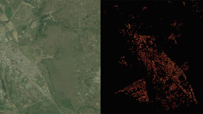
Facebook created a super-detailed population density map
Facebook's quest to get the world online is paying some unexpected dividends. Its Connectivity Lab is using image recognition technology to create population density maps that are much more accurate (to within 10m) than previous data sets -- where earlier examples are little more than blobs, Facebook shows even the finer aspects of individual neighborhoods. The trick was to modify the internet giant's existing neural network so that it could quickly determine whether or not buildings are present in satellite images. Instead of spending ages mapping every last corner of the globe, Facebook only had to train its network on 8,000 images and set it loose.

Xprize offers $7 million for exploring the ocean floor
After years of focusing on moonshots and other lofty goals, the Xprize Foundation now hopes to inspire innovation in the opposite direction... in a very literal sense. Its new Shell Ocean Discovery Xprize is offering a total of $7 million in awards to teams that can deliver robotic exploration of sea floors as deep as 4,000m (13,123ft). The $4 million grand prize and a $1 million runner-up prize will go to the groups that deliver the sharpest maps on top of meeting baseline requirements for autonomy, depth and speed. The top 10 teams will split a $1 million milestone prize, while the National Oceanic and Atmospheric Administration is chipping in another $1 million for teams that spot objects through biological and chemical clues.

Uber signs up TomTom to provide navigation for its drivers
After losing out to a consortium of Germany's biggest car makers over the purchase of Nokia's HERE Maps, Uber has set about building its own mapping and navigation services. They're not quite ready for prime time, so the company has had to rely upon a number of popular mapping services, including Google (which also serves as an investor), to help both users and drivers understand exactly where they are. Today, Uber has added TomTom to the list, with the Dutch company confirming that it will also support the private hire taxi firm.

Apple is quietly working on a new indoor mapping system
Apple has discreetly released an RF-based interior positioning app called Indoor Survey, as spotted by developer Steve Troughton-Smith. It appeared recently on the App Store, and the description says you can "drop 'points' on a map within the Survey App [to] indicate your position within the venue as you walk through. As you do so, the Indoor Survey App measures the radio frequency (RF) signal data and combines it with an iPhone's sensor data." That lets you find your position inside a mall, arena or other venue "without the need to install special hardware," according to Apple.

Uber starts rolling out its own mapmaking cars
This past June, Uber struck a deal with Microsoft to acquire some of Bing's mapping tech and staff. But back then neither company was willing to disclose specific details about the agreement, with both only going as far as acknowledging it had actually happened. Now, BuzzFeed News reports that the ridesharing service has started deploying its own mapping vehicles, which are said to be the same ones Microsoft previously owned and used in its efforts to capture street data. Uber's rebranded cars (pictured above) are similar to Google's StreetView fleet, featuring a 3D spherical camera capable of snapping locations around it. An Uber spokesperson told BuzzFeed News the company's hoping the image-capturing tech will help it improve in key areas for drivers and passengers, including better route information and more accurate estimated time of arrivals.

TomTom's RoadDNA system helps anyone build a self-driving car
TomTom has launched RoadDNA, a product aimed at bringing self-driving car tech to more potential developers. The system captures 3D roadside data from depth sensing cameras and compares it to a database of images, letting vehicles know their exact position on the road, even at high speeds. The mapping company said it takes "vehicle data storage and processing limitations in mind," by converting the mass of 3D data it collects into a manageable, optimized 2D view of the road. TomTom said earlier that the RoadDNA database takes up just 25 Kb per kilometer of road.

Waze sued for allegedly stealing map data
Google and its mapping service Waze are being dragged to court over allegations that Waze stole data from a rival's map database. The lawsuit filed in San Francisco federal court on Tuesday by PhantomAlert alleges that the navigation app used proprietary data from PhantomAlert without permission. Both apps share road, red light and traffic information. According to PhantomAlert CEO Joseph Seyoum he noticed that Waze was using the same fictitious location information in its app that his company had used to test PhantomAlert. The only way Waze would have that fake location data is if it was using information from Seyoum's company.

NYT: Uber loses bid for Nokia Here's maps to German automakers
It looks like Uber has been shut out of the purchase of Nokia's mapping service Here by BMW, Audi and Mercedes-Benz. According to the New York Times, Uber is out of the running to purchase the mapping division which it had been rumored to have bid $3 billion. Uber isn't the only company that's been sidelined by the three german automakers. According to the NYT's sources, Chinese companies Baidu and Tencent were also initially interested in the mapping technology, but have since lost interest. The automakers have long used Nokia's mapping technology in their vehicles' onboard navigation systems. Uber on the other hand, would be able to own the technology to help it better serve its passengers. While Uber may be out for now, if negotiations with the three automakers break down, the car-sharing company could be back in the running.

Bing Maps adds trip-planning tools and easy access to reviews
If you prefer Bing Maps as your go-to navigation tool, the software's preview version received a big redesign. Focused primarily on helping you plan trips, a load of new features aim to make it easier to search, view and share multiple destinations easily. Bing Maps Preview will pull in reviews and photos from Yelp in its search results, so you'll have quick access to suggestions when traveling in an unfamiliar locale. When it comes to planning an evening out, for example, there's a new card-based format to keep each stop a few taps away. For those entries, hours, useful details and similar options nearby are all included. Bing also employs predictive routing to help you determine the best time to head, showing you what traffic would be like for a specific time of day.

Apple Maps minivan spotted in the wild
Earlier this year, a few eagle-eyed folks in the East Bay region in Northern California noticed unmarked minivans with what looked like an array of cameras and sensors sitting on top of it. It turns out that the vehicles were registered to Apple, which sparked a bunch of speculation that the Cupertino firm was deploying its own fleet of mapping vehicles to compete with Google Street View. Well, as was revealed earlier this month, that is certainly the case. In a photo captured by our friends over at Autoblog, a Dodge Caravan with the same sort of camera assembly was spotted with a decal that clearly states "Apple Maps" and "maps.apple.com" on the back window. As the company's own information page states that it will "blur faces and license plates on collected images prior to publication," it seems that Apple Maps could very well get its own Street View-esque feature in the future. If you're interested in spotting these vehicles for yourselves, Apple has posted the schedule of where they'll be driving around next.

Mapping project catalogs Instagram sunrises from around the world
Have you noticed the wealth of sunrise and sunset photos on Instagram? Michelle Chandra certainly has, and her project offers a look at the sun's activity around the world in real time. "All Our Suns" gathers snapshots upload with either the #sunrise or #sunset hashtag, using the posts to populate a set of data-driven maps. Two of the crowdsourced cartography pieces catalog every image that's uploaded during the course of a 24-hour period -- one for sunrises and one for sunsets based on a user's location. What's more, you can click on a location marker to view the photo. A third map notes times when two people are posting at the same time, with one updating the beginning and the other observing the end of a day. The whole thing is a study on how our lives literally revolve around the sun and how social networks illustrate time as a never-ending loop.

Facebook taps Nokia for its mapping know-how
If Facebook's maps for mobile have suddenly gotten a whole lot more (or less) accurate, there's a reason. The social network is now sourcing its location data from Here, Nokia's soon-to-be-sold mapping division. According to TechCrunch's sources, only the mobile web version is using the new information, but Facebook is currently testing whether to roll Here's Maps out to all of its standalone apps like Messenger and Instagram. It's hoped that, with more accurate geolocation data, the company can offer advertisers even more minute control over who gets what product thrown in their face. Of course, Facebook is also one of the companies that is believed to be considering buying Here outright. Given this news, however, we'd imagine it being a lot less likely -- after all, why buy the cow if you're getting the milk for free?

Nokia's Here Maps finally returns to iOS
Although Nokia is no longer in the smartphone game, it has remained committed to its other businesses. One of those is its mapping division, which almost six months ago debuted a new Android app capable of giving Google Maps a run for its money. At the same time, Nokia teased the launch of a completely overhauled iOS app, but its development has been shrouded in relative secrecy. Nokia pulled its first iOS Maps app after admitting things "went horribly wrong," and its developers have had a lot of work to do to make sure it doesn't suffer a repeat this time around. The company believes it's ticked all the requisite boxes as it's now available to download on the App Store. Is it good enough to replace Google Maps or condemn Apple Maps to more misery? We took the chance to preview the app and find out.

Google Street View cameras zip through (and over) the Amazon
Google already has some odd ways of getting its Street View cameras into hard-to-reach places, but its latest effort might just take the cake. The search firm has posted panoramic imagery of the Amazon rainforest that, at some points, was taken by Trekker cameras ziplining through the canopy -- yes, you'll get a view that even locals won't usually see. There are some down-to-Earth sights, too, including snapshots from rivers and remote villages. Between this and recent collaborative mapping projects, you may end up learning a surprising amount about the Amazon without setting foot in South America.

Apple is driving camera-equipped minivans around California
Apple technology doesn't normally venture on to the open road outside of CarPlay, but the company is clearly ready to hit the street with something new. Claycord, CBS and others have spotted unmarked, Apple-registered minivans driving around California (and possibly New York) sporting an abundance of cameras and (maybe) sensors. Neither the drivers nor Apple are willing to say what the vans are up to. Some are quick to speculate that these are autonomous vehicle prototypes meant to take on Google's self-driving car, but it's not certain that this is the case. Apple may just as easily be using these vans to add Street View-style panoramas to Maps, improve the accuracy of its existing map data or something else altogether. One thing's for certain: between this and talk of an Apple search platform, the crew in Cupertino is ready to explore unfamiliar territory. [Image credit: Claycord]
Russia lets anyone use Earth-sensing data from its civilian satellites
The US government has been willing to loosen its grip on satellite data, but what about the info from other countries? Don't worry, that's opening up as well. Russia has declared that the Earth-sensing data it collects from civilian satellites is now available to the public, not just the government -- if you want to track St. Petersburg's urban sprawl, you probably can. Officials are keen to tout the advantages for Russian businesses that rely on maps, but the move should also help anyone who wants a more complete picture of how the world works. [Image credit: AP Photo]

Google Earth's third-party app support is going away, for now
Google Earth's technology has led to some pretty cool third-party projects over the past six years, but you may not see many of those efforts for at least a little while. Google has announced that it's retiring Earth's app programming interface within a year. Any mapping software built using that kit will stop working on December 12th, 2015. As the company explains, it's simply a matter of security. Chrome and Firefox are phasing out support for the old, vulnerable Netscape plugin format that Earth uses for third-party web apps, and Google doesn't want to leave people open to attack. This isn't necessarily the end for broad Earth support, mind you. Google notes that "3D is in [its] blood," and is teasing that there's more in the pipeline. It's not clear that this includes a new toolbox, but you may not have to worry about a dearth of clever maps just yet.

Microsoft rolls out Bing Maps traffic guesstimation worldwide
Bing Maps users outside the US will now have a better idea of how long it takes to get from A to B, as Microsoft has just launched Clearflow traffic estimation around the world. The system works by taking live traffic data for main roads and surface streets, then extrapolating it to unreported routes. That differs drastically from Google's approach, in which speed and position data is sent from each Maps user's device to estimate live traffic conditions. Google relies on strength in numbers of its Android (and Maps) ecosystem, which Microsoft lacks -- but Bing Maps uses Nokia's well-regarded Navteq traffic system. Whichever you use, you're now more likely to duck traffic and arrive at the ball on time.

Mail carriers are mapping Brazil's favelas before tech companies can
Google and Microsoft may be trying hard to produce online maps for Brazil's favelas, but they've already been beaten by an old-fashioned (if very clever) paper solution. A private mail-delivery service operating in the Rocinha favela, Friendly Mailman, has been methodically charting the slum by using handwritten algorithms that detail every street and building. This system is indecipherable if you aren't one of the mail carriers, but it's reportedly very effective -- staff can both deliver packages to unofficial addresses and adapt to the favela's ever-changing landscape. Apparently, the approach is good enough that Google unsuccessfully requested a photo of Friendly Mailman's map. While that refusal isn't good news for internet users wanting to understand the favelas, the analog code is already helping locals send letters, receive online orders and otherwise communicate with the world at large. [Image credit: Mario Tama/Getty Images]

Nokia's Here Auto tries to predict your driving needs (hands-on)
Okay, let's get this out of the way: it's not Nokia Here anymore, just plain old "Here." Nokia's VP of Connected Driving, Floris van de Klashorst, told me that Here no longer uses the Nokia name and is fully independent (though it's still 100 percent owned by Nokia). That settled, Here Auto was launched last year as Nokia's connected car solution for automakers, competing with Apple's CarPlay and Android Auto. Nokia beat both companies to the punch, however, and it definitely shows. The latest version of Here Auto, launched at the Paris Auto Show, has very few rough edges. It's designed to think ahead of you, learn your habits, work with other devices and present information and options in the least distracting way possible. That's Nokia's goal, anyway -- to see if it succeeded, I took a tour around Paris in the company's Range Rover demonstrator.


