TopographicMap
Latest
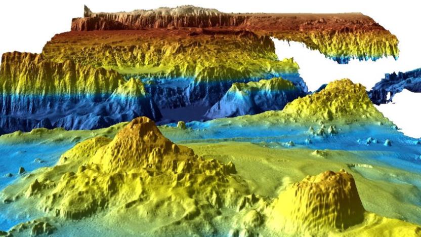
Missing Malaysia Airlines flight search yields valuable seafloor data
In 2014, Malaysia Airlines flight MH 370 disappeared from radar and a massive search for the missing aircraft ensued. For two years, scientists used sonar to map the seafloor where the plane was thought to have crashed, and then search for any remnants. Nothing was found and the search was officially called off this past January, but the data collected during the search has now been released.

Open data gives rise to a virtual Denmark in Minecraft
Since the US government opened its troves of public data we've seen some pretty neat projects like climate-change prediction tools and deforestation-monitoring systems. Denmark, on the other hand, has taken a different approach: the Danish Geodata Agency used internally developed topographic maps and elevation models to build a 1:1 recreation of the happiest country within Minecraft's blocky confines. Unlike the virtual Great Britain we've seen before, this pixelated Denmark is more than just natural features like hills and forests. As Ars Technica has spotted, it includes accurate replicas of highways, homes, landmarks and businesses too. The project was intended to showcase the country's open-data initiative to its students and educators, but anyone can take a gander until the Danish government's game servers shut down in late October. Server rules, however, have disabled enemies and TNT -- no Creeps allowed, naturally.

Daily iPhone App: Topo Maps+ is your best backcountry companion
There's nothing like having a good set of topographic maps when you are hiking in the backcountry. Paper maps are the de facto standard, but they tear easily, get wet in the rain and can easily blow away with a stiff gust of the wind. If you have an iPhone in your pocket everywhere you go and want a more permanent set of maps, then you should check out Topo Maps+ from Glacier Peaks Studio. As someone who spends a lot of time outdoors, I can reliably say that the most important feature of Topo Maps+ is its support for offline usage. You can be deep in the woods, far from any cell signal and still use the app to navigate from waypoint to waypoint. Before you hit the trail, just remember to download the maps in advance. You can then use the iPhone's GPS and compass along with the maps in the field. For planning purposes, there's also a trace route feature that allows you to layout your trip by tracing your path on the map.The traces can be superimposed on a topo map and then viewed on a satellite map, allowing you to get a different view of your path. You can also use these traces to estimate distances and elevations between two waypoints. Topo Maps+ is available for free in the iOS App Store. There is a demo mode that allows you to check out the major features of the app, but you will need to buy a subscription if you want usable maps in your location. Pricing starts at US$4.99 for two months of access to all the maps or six months of access to only the USGS & Thunderforest Topo Maps. Year-round access to all the maps will cost you $14.99. Topo Maps+ include the following maps: USGS 7.5-minute topo maps for the continental USA, Thunderforest Topo maps, MapBox Terrain, MapBox Satellite and Open Street Map maps.

Topographic maps illustrate where Twitter's bird flies highest
Not every Twitter user geotags their musings, but there are enough who do to generate some very insightful data. On its blog today, Twitter shared images from Data Visualization Scientist Nicolas Belmonte, who created topographic maps visualizing the density of geotagged tweets. The result is striking, as tweets clearly correlate with roads, geographic features and even lines of public transit. In addition to the blog's stills, you can futz around with interactive maps of New York, San Francisco and... Istanbul. When you realize the implications of all those tweets from the Bay Bridge, it's frightening enough to consider taking BART across the Bay instead.

NASA creates the first topographic map of Titan, Saturn's largest moon
Scientists observing Saturn's moon Titan with NASA's Cassini spacecraft have boldly gone where no man has gone before -- visually, anyway. Using radar imagery collected from nine years of Cassini flybys, researchers were able to patch together the first global topographic map of Titan, published in the July 2013 issue of Icarus. Ralph Lorenz, a member of the Cassini radar team at Johns Hopkins, said, "Titan has so much interesting activity -- like flowing liquids and moving sand dunes -- but to understand these processes it's useful to know how the terrain slopes." In particular, understanding the moon's terrain can reveal a lot about its dynamic climate system. Like Earth, Titan's atmosphere is composed primarily of nitrogen, but the liquids and vapors on the moon's surface are made of methane and other organic chemicals integral to the creation of complex life. By studying the relationship between atmosphere and terrain, researchers hope to learn more about the evolution of life in its earliest stages, and inspire curious minds to turn their eyes toward Titan.

National Geographic TOPO! maps find their way to Magellan eXplorist GPS devices
If you're more about the mountainous views, than Mountain View, then you might be pleased to hear that Magellan is bringing National Geographic's TOPO! maps to its eXplorist range of outdoor GPS devices. More specifically the 310, 510, 610 and 710 models. If you like the sound of the full color USGS topographic maps, then they are available on a subscription basis for $30 a year. If you don't already own a Magellan device, however, then you might be more interested in one of the forthcoming TOPO! bundles, if you can find your way to a retailer that is.

NASA creates high-res Moon map, taunts you about your terrestrial tethers
Chances are you will never set foot on the Moon. Sorry, we don't mean to rain on your parade (alright, maybe we do), but the closest you'll ever get is looking at pictures or traipsing around Google Moon. NASA's LRO (Lunar Reconnaissance Orbiter) has been circling our rocky satellite capturing such images, and now 69,000 of them have been stitched together to create the highest resolution topographic map of the lunar surface ever. The Global Lunar DTM 100 m topographic model has a scale of roughly 100 meters per-pixel, allowing researchers to better understand how the crust is formed and accurately scout landing sites for future missions -- be they robotic or manned. Check out the source for a larger image and a few more details.

Garmin's Astro 320 GPS handheld offers nine-mile coverage, keeps your hunting dogs in line
Before you and your pooches head out to hunt innocent ducks this year, you might wanna check out Garmin's new Astro 320 dog tracker -- a handheld GPS device designed to help hunters keep even closer tabs on their four-legged sentries. The latest addition to the Astro family can simultaneously track up to ten hunting dogs per receiver, with a revamped antenna and three-axis electronic compass covering up to nine miles of flat terrain. Boasting a 20-hour battery life, the 1.7GB handheld can also tell hunters whether their canines are running or pointing, while its mapping capabilities provide their precise coordinates relative to powerlines, buildings, and individual trees. All this information is displayed on a 2.6-inch display, where users will be able to access 100k or 24k topographic and satellite maps. A keypad lock function, meanwhile, will make sure you don't accidentally press any buttons while you're in the thick of a hound-led hunt. The handheld will be available in July for $500, with the full system (including a DC 40 tracking collar) priced at $650. You can flip through the gallery below for images of some antenna-toting doggies, or head past the break for a more testosterone-laced pic and the full PR. %Gallery-125121%

Garmin announces redesigned line of eTrex GPS handhelds with enhanced geocaching
Lost hikers and outdoorsmen will soon have yet another arrow to add to their navigational quivers, now that Garmin has decided to upgrade its eTrex line of GPS handhelds. The refresh, announced this morning, will bring three new models to the eTrex family during the third quarter of this year. First up is the eTrex 10 -- a basic, $120 little guy that carries a global database of locations, as well as a monochrome display that can be read under the sun. The $200 eTrex 20, on the other hand, displays images in 65k color on a 2.2-inch screen and can support topographic, roadway and marine maps. At the high end of the spectrum is the eTrex 30 ($300), which offers all the features you'll find on the eTrex 20, plus a tilt-compensated electronic compass, barometric altimeter and wireless data transfer capabilities. All three models allow users to download geocached information directly to their devices and boast a lengthy 25-hour battery life -- giving you plenty of time to find your bearings before calling in the rescue squad. Full PR after the break.

Hitachi's worker tracking tags
If you're an employee of a large company, you probably worry that your higher-ups are watching your every move, keeping track of how long you take for lunch, and going through your personal emails. Well, Hitachi has taken it to the totally 1984-esque next level with an electronic "name tag" which employees wear around their neck, used to track their personal movements, as well as proximity to, and interaction with co-workers. The tags also include radiation sensors (?), sound sensors and a radio communication device -- just in case you felt you weren't being watched enough. The collected data shows strengths and weaknesses amongst groups of workers in an organization, forming a topographical map which Big Brother will use to decide who gets made into Soylent Green.


