topography
Latest
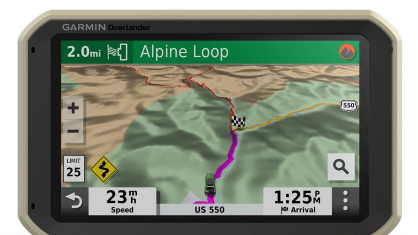
Garmin's latest GPS is designed for off-road explorers
With GPS now a basic cell phone feature, and more vehicles rolling off the production lines with built-in satnav systems, the role of standalone satellite-navigation devices is diminishing. Why have an extra bit of kit in your car that needs additional maintenance? But Garmin thinks there's still a place for them, particularly in the world of off-roading and overlanding.

Scientists finally made a half-way decent map of Alaska
To protect the Arctic from climate change, scientists require a detailed map which they can slowly update and reference over time. Such a resource has, until now, been difficult to produce because traditional capture methods -- low-flying aircraft, for instance -- are expensive or ill-equipped to deal with the region's harsh weather patterns. That's now changed, however, thanks to a project spearheaded by the National Geospatial-Intelligence Agency (NGA) and the National Science Foundation. Following a directive from President Obama, the group has captured Alaska with a new level of clarity, using commercial satellites owned by Digital Globe.

These 'Minecraft' worlds will teach you about UK geology
One of the reasons Minecraft is so popular is that it gives players a blank slate on which to build whatever creations their imaginations can conceive. This level of freedom has led to entire cities and even countries taking on a virtual form, though sometimes our destructive nature can be just as strong as our passion to create. The British Geological Survey (BGS) is one of many organisations using Minecraft to build worlds that are both fun and educational, having already made a scale model of Great Britain based on Ordinance Survey data. Now, though, the BGS has gone beyond the surface to recreate the underlying geology of Ingleborough, West Thurrock and York in pixelated blocks.

NASA creates the first topographic map of Titan, Saturn's largest moon
Scientists observing Saturn's moon Titan with NASA's Cassini spacecraft have boldly gone where no man has gone before -- visually, anyway. Using radar imagery collected from nine years of Cassini flybys, researchers were able to patch together the first global topographic map of Titan, published in the July 2013 issue of Icarus. Ralph Lorenz, a member of the Cassini radar team at Johns Hopkins, said, "Titan has so much interesting activity -- like flowing liquids and moving sand dunes -- but to understand these processes it's useful to know how the terrain slopes." In particular, understanding the moon's terrain can reveal a lot about its dynamic climate system. Like Earth, Titan's atmosphere is composed primarily of nitrogen, but the liquids and vapors on the moon's surface are made of methane and other organic chemicals integral to the creation of complex life. By studying the relationship between atmosphere and terrain, researchers hope to learn more about the evolution of life in its earliest stages, and inspire curious minds to turn their eyes toward Titan.

SandyStation interactive sandbox uses Kinect to make topography much more interesting (video)
If you're not really into using your Kinect experiment to launch your new startup or give your next presentation, let us offer another entertaining option. Two students at the University of West Bohemia in Pilsen have created an interactive sandbox using Kinect, a projector, a computer and, of course, a box chock full of sand. The Xbox motion / depth detector is installed about two feet above the sand pit to measure each area that is carved out. Using a unique detection program, the topographical information is then transmitted to a data projector that renders an image in the sandpit -- the image being a color based on the height or depth of what has been created. The devs have built out a few different projections. Hills that are constructed by the user are assigned a shade of green based on height, while troughs are given blue hues according to depth. What's that? You built a hill and dug out the center? The projector sees that as a volcano, complete with spewing lava. If you're tired of SimCity and want to actually get your hands dirty, take a peak at the video just past the break. [Thanks, Mark]

Garmin releases aera 795, 796 flight navigators, private jet not included
The GPS gurus over at Garmin have just launched the aera 796 and 795 -- a pair of new navigation devices designed specifically for pilots who don't enjoy getting lost. As the flagship member of the aera family, the 796 sports a seven-inch, 480 x 800 capacitive touchscreen (capable of displaying maps in either landscape or portrait mode) and features Garmin's 3D Vision technology, providing users with a behind-the-plane view of the terrain below, including rivers, landing strips or any other obstacles. This knee-mounted co-pilot can also serve as an electronic flight bag, allowing captains to digitally store flight routes and airport diagrams directly on their devices. Plus, if it's hooked up to a compatible GPS system, the 796 can provide real-time traffic updates, while streaming SiriusXM radio straight to the cockpit (the North America-specific 795 features identical specs, minus XM compatibility). Aviation enthusiasts can buy the 796 and 795 for the respective prices of $2,500 and $2,200, at the source link below. Full PR after the break.

Mophie intros Juice Pack Plus Outdoor Edition for adventure loving iPhone owners (video)
It's been just over a week since Mophie quietly intro'd updated Juice Packs at IFA, and now -- as we've reacquainted with our offices -- the company's given us a sneak peek at its Juice Pack Plus Outdoor Edition. Aside from a special olive drab and orange colorway, the charging case itself is your standard $100 iPhone 4 Juice Pack Plus. So what's the big deal, you ask? This Pack's bundled with Mophie's Outdoor Navigation app (a collaboration with NeoTrecks) positioning itself as an alternative to pricier handheld GPS units. Purchased separately, said app's slated to sell for $30 along with optional desktop access priced at $20 annually, while you'll get the software and that first year included out of box with the OE. The app works using your iPhone's GPS to provide highly detailed maps and a robust suite of options to get you where you're going, even if you're offline for most of the US -- sorry, Alaska. We checked out an early build of the software showcasing its three modes for tracking, downloading new maps, and a library you can check back on. The maps feature hand-shaded topography for extra clarity and a unique "grid-mode" for downloading new sections, although it appears you'll be stuck there while you wait for it to finish. The software also pulls up points of interests and you'll be able to track your trips, allowing you to then view your statistics or even share the details over the web. Mophie's expecting to have these available sometime in October with full details forthcoming, but in the meantime, there's a brief demo on how it'll help you navigate your local trail past the break. %Gallery-132904%

The Perfect Ten: Best in-game maps
I love me a good map. Seriously. When I was a boy and we'd go on vacations, I think I spent more time flipping through the detailed atlas in the car than looking out of the windows (and how sad is that?). Even today, I'm fascinated with a good map, as it allows my imagination to roam across lands quickly and imagine what they must be like. In MMOs, maps are one of the most important tools in your user interface. They help orient you, direct you to your next quest objective, allow you to plan a journey in the safest possible manner, and tantalize you with the potentials of unexplored areas. I started to think about how much we rely on a good in-game map when I was reading the Star Wars: The Old Republic dev diary on how that team is implementing their map system. I've found that in-game maps can be a mixed bag, depending on the game you visit. Some may look great but be functionally useless. Some may be uglier than dirt but hit the spot nevertheless. But the best are the ones that marry good aesthetics with practicality, and those are the ones I want to spotlight today. So without further ado, my favorite in-game maps from MMOs!

Garmin announces redesigned line of eTrex GPS handhelds with enhanced geocaching
Lost hikers and outdoorsmen will soon have yet another arrow to add to their navigational quivers, now that Garmin has decided to upgrade its eTrex line of GPS handhelds. The refresh, announced this morning, will bring three new models to the eTrex family during the third quarter of this year. First up is the eTrex 10 -- a basic, $120 little guy that carries a global database of locations, as well as a monochrome display that can be read under the sun. The $200 eTrex 20, on the other hand, displays images in 65k color on a 2.2-inch screen and can support topographic, roadway and marine maps. At the high end of the spectrum is the eTrex 30 ($300), which offers all the features you'll find on the eTrex 20, plus a tilt-compensated electronic compass, barometric altimeter and wireless data transfer capabilities. All three models allow users to download geocached information directly to their devices and boast a lengthy 25-hour battery life -- giving you plenty of time to find your bearings before calling in the rescue squad. Full PR after the break.


