transit
Latest
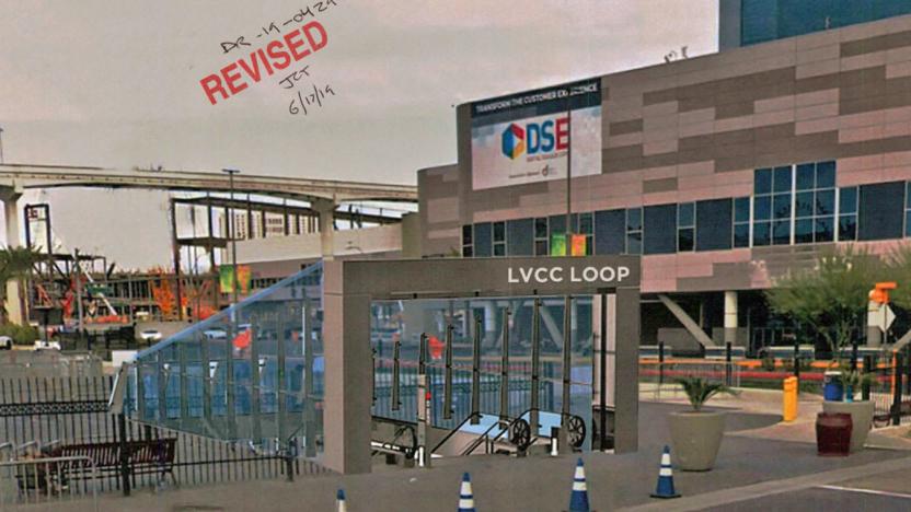
Musk's Las Vegas tunnel plans are worrying Monorail officials
Planning documents, obtained by TechCrunch, are revealing much about how Elon Musk's proposed Las Vegas loop would work. The Boring Company is charged with building three tunnels: one for pedestrians and two for passenger "sleds," stretching across the Las Vegas Convention Center Campus. The two vehicle tunnels will be filled with a fleet of autonomous Tesla-based EVs that can carry up to 16 people at a time.

London Underground will track everyone's Tube trip via WiFi
Transport for London, the UK capital's transit authority, will start collecting data on how people move around the Underground system by tracking phones and other connected devices using its extensive WiFi network. The agency's systems will depersonalize the data automatically and won't pick up any browsing or historical information from the devices. The data should offer sturdier details on how people move around the Tube system and even within stations, which will help the agency with long-term planning and providing effective updates to travelers.

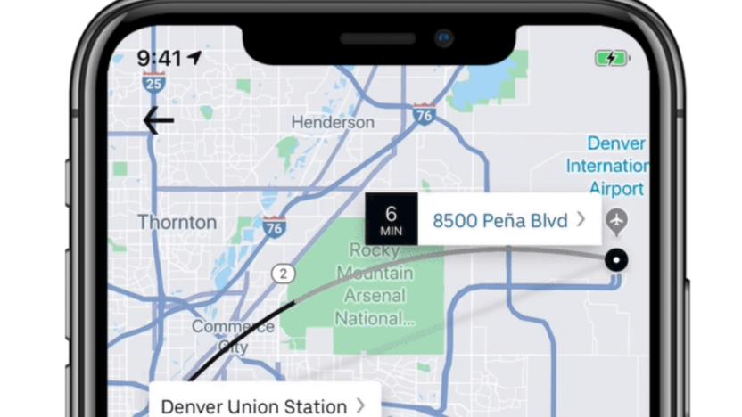
Denver Uber users can buy public transit tickets in the app
Uber customers in Denver can now use the app to purchase transit tickets. This makes Denver the first city in the world to get the added capability, but it won't be the last. It's all part of Uber's goal to make the platform a one-stop shop for transportation needs, from carsharing to bikesharing, busses and more.

Los Angeles is fighting for e-scooter data
The City of Los Angeles is fighting for access to data from an unlikely source: scooters. City officials want to use location data from Uber-owned Jump's dockless scooters to inform public transit policies. But the company says that could lead to "an unprecedented level of surveillance," which the city could wield over companies and citizens, Politico reports.

Google Maps can find you Lime scooters in more than 80 cities
Starting this week, you'll be able to use Google Maps to locate Lime scooters, bikes and e-bikes in more than 80 cities. In a trial-run that began last December, the app gave transit users a Lime option, but it was limited to 13 cities. By the looks of this expansion, the test-run went well.
Uber adds public transportation options to its app
Uber is primarily thought of as a ridesharing service, but today the company is adding new transportation options to its app -- even though they don't involve the users actually taking an Uber ride. Denver's Regional Transportation District (RTA) has been added to the Uber app, which means that people searching for a ride will also see what public transportation options are nearby that can get them where they're going.
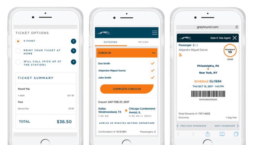
Greyhound joins the modern era with e-tickets on iPhones
Intercity bus service Greyhound might not be the quickest way of getting around, but purchasing tickets is at least a bit faster now thanks to the new (and arguably well overdue) e-ticketing feature on its iOS app. Passengers can buy tickets directly through the app, then simply flash their device at the driver as they board the bus. Every aspect of a trip can be managed through the app, including check-in, updates and live departure times, plus member rewards. And if you're about to get on a long bus journey, chances are your phone's already juiced up, so you needn't worry about misplacing your info -- unlike Android users, who still have to wait for their update.
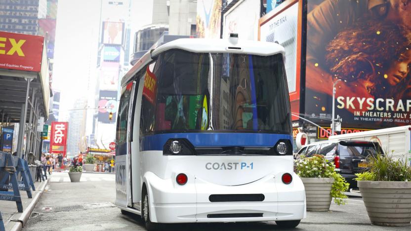
Riding an autonomous shuttle through Times Square was reassuringly boring
Yesterday afternoon, I rode an autonomous shuttle down a short section of Broadway in the heart of Times Square, and it was easily the most boring part of my day. I'm not saying that because my life is particularly exciting, either. The trip was boring because everything inside the Coast Autonomous P-1 worked exactly the way it was supposed to: The shuttle crawled up to a barricade on 47th Street, paused for a bit, and scooted back in the opposite direction toward 48th. In this case, the vehicle wasn't completely autonomous -- Coast CTO Pierre Lefevre manually started each leg of a trip with an Xbox Elite controller -- but the P-1 navigated its surroundings all own its own.
Google Maps for iOS now shows restaurant waiting times
Last month Google Maps for iOS got an update that brought users real-time transit and driving information. Today, a further update brings the app to version 4.47 and in line with the Android version, with additional transit details and a helpful restaurants feature that shows the average waiting times of over a million sit-down eateries around the world.
Google Pay now lets Las Vegas Monorail riders use phones to board
Google announced today that it's making purchasing and using tickets for the Las Vegas Monorail a little bit simpler. Now, riders will be able to buy tickets online through the Monorail site, save them to Google Pay and then just wave their phone near the fare gate to board. You don't even need to open the app. Once your ticket has been accepted, a blue check mark pops up on your screen and you're good to go.
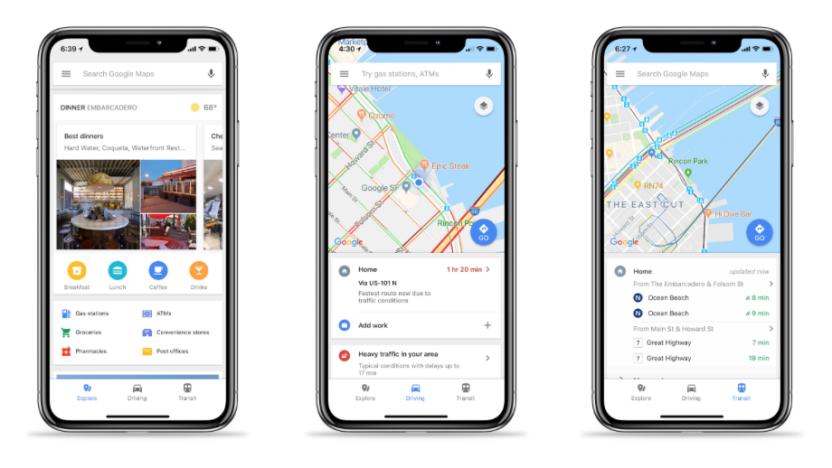
Google Maps for iOS adds easy access to traffic and transit info
Over a year ago, Google updated its Maps app for Android, making it easier for users to search for restaurants, check out nearby traffic and find public transit schedules. Today, that update is now available for iOS users. With the update, Google Maps users will see three options on the bottom of their screens -- explore, driving and transit.
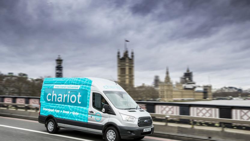
Ford’s Chariot ride-sharing vans come to London
Chariot is Ford's attempt to launch its own quasi-public transport system with a fleet of minibuses designed to serve flush commuters. The service has seen some success in the US, and operates routes in San Francisco, Austin, Seattle, Columbus and New York. That's enough to convince Ford to take the service worldwide, with the first European routes launching in London.

Coord feeds real-time transportation info into navigation apps
Google Maps might plot the fastest route to your destination, but it doesn't tell you the smartest (or cheapest) place to park. Coord wants to fix that by supplying parking, toll and parking information for companies to plug into their other apps and services using an API.
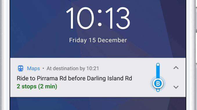
Google Maps will now tell you when to get off the bus or train
A mass transit feature for the Android version of Google Maps that notifies you when you need to get off the bus is finally live. It also includes step-by-step navigation, departure times and ETAs for your next public transportation ride. You can also track your progress as you go, just like you can when walking, biking or driving.
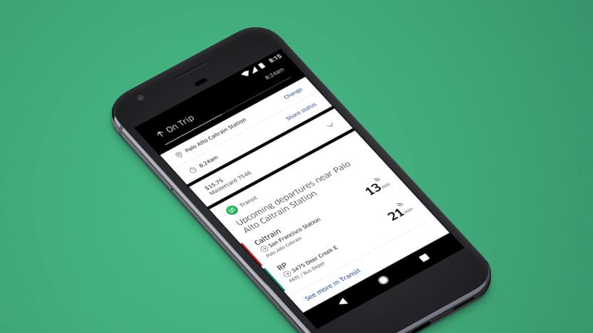
Uber really wants to be your one-stop transit app
While you'd think that Uber would balk at mass transit, it's really quite friendly to the concept. One of its best-known third-party app tie-ins, Transit, lets you hail a car from the same app that gives you real-time bus schedules. And now it's returning the favor: an update to Uber's Android app (iOS is coming) shows you Transit-sourced departure times within a block of your destination. If you need to catch a commuter train and are wondering whether or not you'll reach the station in time, you won't necessarily have to jump between apps. You'll still need to launch the dedicated Transit app to see a wider list of departures, but it's hard to knock the convenience.

Google Maps now offers easy access to important info
Google Maps' Marcus Lowe has announced a tweak to the service that makes it significantly more useful for Android users. Nestled at the bottom of the home screen will be a new section containing real-time information for busy travelers. Simply swipe up and you'll be presented with three tabs offering data that'll ensure you never need to consult a third-party app again. At least, that's Google's plan.

Singapore will trial a full-size autonomous bus
Singapore will trial a pair of driverless buses. No, not micro buses, nor "Ollis" -- full-sized buses, measuring 12 meters (40 feet) long. The vehicles will operate in the Jurong West region of Singapore, where the island's Nanyang Technological University (NTU) is situated. The buses will ferry up to 80 people between NTU and the neighboring "eco-business" hub CleanTech Park -- around a one-mile journey. The team behind the trial is also considering servicing a nearby train station, which would extend the route to around a 5-mile round trip. The vehicles will charge at depots and at bus stops via charging masts.
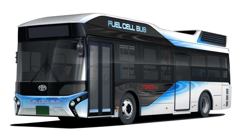
Toyota's hydrogen buses can work as emergency generators
Toyota will start selling fuel cell (FC) buses in 2017, with the aim of selling up to 100 in the Tokyo area ahead of the 2020 Olympic games. The company is using a beefed up version of the fuel system it developed for the Toyota Murai, with 10 high pressure tanks holding 600 liters of highly compressed H2. That gives it 235 kWh or power, about three times that of a Tesla Model S, meaning it "can be used as a power source in the event of disasters," the company said in a press release.

Transit's app now tells you when to hurry for the bus
Sure, your existing phone apps can tell you when to catch the bus and when to hop off, but public transportation fans know that's only half the story. What if the driver is quicker than you expected, or a delay ruins your subway connection? Transit might just save the day. It's updating its Android and iOS apps with a Go routing feature that could take some of the uncertainty out of commuting. You'll get on-screen and voice notifications when it's time to head out or disembark, but it gets truly interesting when things go haywire. Transit will tell you to hurry up if your departure time suddenly skips ahead, create a new itinerary if you miss a ride and warn you if a bus takes a surprise detour.

Google's latest acquisition should make Maps a bit better
Urban Engines has been analyzing city traffic and how people get around. So, naturally, it'd make sense if the company was acquired by an outfit interested in making its maps more efficient. That's where Google comes in. The search giant has bought the Urban Engines with the sole purpose of improving Maps. "Location analytics is an important focus for both Urban Engines and Google, and we're excited to combine forces to help organizations better understand how the world moves," the announcement post reads. It's a little early to tell exactly what Urban Engines will bring to the table for Maps, but based on its history, perhaps better routing around traffic jams is a pretty safe bet.


