Test driving the new Garmin viago navigation app

Garmin launched its new navigation app viago on Tuesday, and I promised to give it a try and review it for you. Garmin provided me the complete kit, so I could install built-in maps, enhanced 3D graphics, and speed and camera traps. It also included urban guidance, which lets you navigate on foot or by public transportation.
Installing everything takes some iPhone space, a bit over 2 GB on my iPhone 5s. It was a s l o w download, likely because there were a lot of people installing viago at the same time. I downloaded the North America map set, which includes all 50 states, and some smaller locations like the Cayman Islands.
Compared to other Garmin and Navigon products that have the same heritage, viago is easier to use with a very clean interface. There are fewer nested menus, so getting up and running is quick and easy. You choose a route by tapping on 'Where to?'. You can enter an address, the name of a city, an intersection, a POI, do a local search, or even enter latitude and longitude. It's also possible to use an address from your contacts, or look at previous destinations or favorites you designate. From there you select your mode of transportation (public, car or walking) and you are on your way. Before you actually start navigating, viago will provide a phone number for your destination if available, and even a weather forecast for that location.
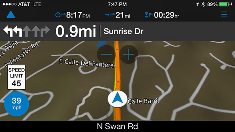
The navigation screen is very nicely laid out, and settings allow you to decide what info is displayed, even your altitude, ETA, how many hours or minutes until your arrival, and more. Selecting a theme for the app varies the colors of the base map and the menus.
My package also gave me my speed and the posted speed limit. Viago can be set to sound an alarm if you exceed the speed limit. While you are in the navigation view, touch a button to get a route overview and a list of all the turns you will make.
The navigation voice is very clear, and this app does something Apple Maps doesn't do — when paired with my car via Bluetooth, viago interrupts the radio or music playback to announce turns. It's really nice, and more closely mimics what a built-in system would do.
Although not needed for navigation, I liked the Panorama 3D view, which shows elevation cues and mountains with shadows. The buidlings option displays major landmarks in a 3D view, which can be helpful when navigating an urban landscape.
The app was quick, and turn information was provided in a timely fashion so it gave me enough time to get into the correct lane. My version was also equipped with lane assistance, providing a diagram of what lane I needed to be in to negotiate a turn.
The POI (points of interest) list was quite complete, allowing me to find places by category like seafood restaurants, pharmacies, ATMs, lodging, etc...
To test how dependent viago is on a data connection, I put my phone in airplane mode and launched the app. The POI database functioned, and it was able to calculate a route. That's positive. Some functions, like weather forecasts, won't show up without the data connection.
If you load up viago with everything you can buy, it totals about $75. That seems pretty pricy, but it is lower than adding similar features to the current Garmin and Navigon apps. For example Garmin USA starts at $50.00, then you add traffic for $20, Panorama view for $10.00, Urban Guiadance for $5.00 and Traffic Cameras for $6.00. That totals $91.00, and it still doesn't have some of the features viago offers. Navigon USA is similarly priced, as are other apps that feature complete on-board maps. You don't have to buy everything, so you can lower the price further by dropping non-essentials like Panorama 3D.
Of course Apple Maps, Google Maps and Google owned Waze are free. Both Google and Apple allow some caching of maps for offline use, but having all the map data on-board is far better when you are watching your data charges or driving in an area with no cellular coverage. Apple has seamless integration with Siri, which is really helpful, plus the Flyover mode which gives 3D photographic views in larger cities.
Here's my view of the good and the bad of viago:
Pros:
- Basic version is inexpensive — just $0.99 on sale — but limited in functionality
- Clean screens
- Fast performance
- Good POI information
- Can customize app to match your needs
Cons:
- Expensive with options, some of which you will want
- No voice interface, unlike Apple, Google and Telenav Scout
- No social ETA system, like Glympse, which Navigon and Garmin offer in their other products . Waze offers this for free
- No ratings for retailers and restaurants. Apple offers Yelp, as do some of the other navigation providers. Navigon offers Zagat ratings in some of their other navigation apps as an additional purchase
What's in the $0.99 version (that price doubles July 13)
- Maps that require a data connection
- Cuurent speed and speed limit display
- Lane Guidance
- photo real junction views
- Route planning
- Traffic in-map info
- Weather at destination
- 2D and 3D navigation
Summing up:
I like viago. It's very well thought out, attractive, efficient on screen, and you won't need a manual. I like the integration of traffic, speed warnings, 3D buildings and the panorama view, but those features all cost extra money. The free version of viago has to download maps over the air just like Google and Apple, but some users may prefer the GUI. I do think viago has the potential to be much better than the current Garmin/Navigon offerings, but it doesn't have complete feature parity yet. viago has some things the other offerings don't, but is missing nice touches like voice interaction and Glympse, although Garmin hints that they are looking closely at these features.
viago is not a universal app, so bad news for iPad users. It requires iOS 7 or greater.