TL18LIDR
Latest

Ancient city's LiDAR scans reveal as many buildings as Manhattan
When researchers surveyed the ruins of a Purépecha Empire city in Mexico the old-fashioned way a decade ago, it took them two seasons to explore two square kilometres. Good thing they decided to use LiDAR, because the city called Angamuco turned out bigger than they previously thought. LiDAR gave the researchers the power to see underneath the lava that covers Angamuco. Thanks to the laser technology, they now know that the city occupied 26 square kilometers of land instead of 13 square kilometers. Colorado State University archaeologist Chris Fisher is presenting that finding and all the latest info on his team's study at the ongoing American Association for the Advancement of Science conference in Austin.
LiDAR reveals Mayan mega city hidden in Guatemalan jungle
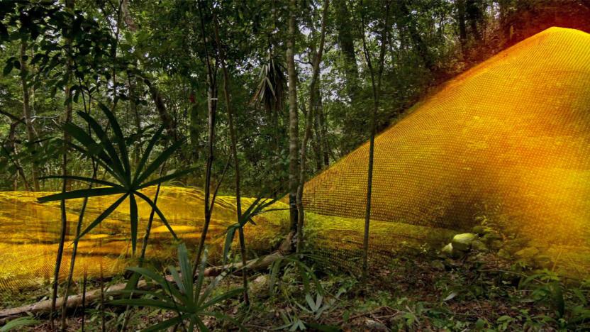
A vast Mayan megalopolis apparently lies hidden underneath all the trees, creepers and centuries of growth and soil in the Guatemalan forest -- and we might never have found it if not for the wonders of laser technology. The PACUNAM Foundation, which champions the use of scientific research to preserve cultural heritage, has scanned the jungles in the country using Light Detection and Ranging (LiDAR) technology and found an interconnected network of ancient cities. They discovered 60,000 previously unknown structures without having to cut down a single plant, and that discovery changes many things we thought we knew about the ancient civilization.

LiDAR strips landscapes down to their bare glory
LiDAR is having a moment right now helping self-driving cars and robots not hit things, but don't forget about what else it can do. In a study called The Bare Earth, scientists from the Washington Geological Survey used it to image the ground right down to dirt and rocks. Stripped of trees and other distractions, the images provide not only valuable geological survey data, but stunning, otherworldly views of our planet.

Cadillac’s Super Cruise maps are key to our robotaxi future
Cadillac is doing something new with LiDAR. Instead of sticking a puck on its cars, it's using the sensors to map the highways of the United States and Canada and geofence its semi-autonomous Super Cruise feature, instead of letting drivers use it anywhere they want. It seems like a bold move, but in reality, it's how self-driving cars will initially enter the market.

See London through the eyes of a self-driving car
When a driverless car glides down the street, avoiding pedestrians and stopping at traffic lights, what exactly does it see? Is the machine's perspective of the world so different to you and me? To give us an inside look, ScanLAB Projects strapped a laser scanner to a Honda CR-V and cruised through the streets of London. Although the car was being driven by a human, the LIDAR (light detection and ranging) equipment performed similarly to how it would in a driverless car. Like radar or sonar, this involves firing a laser in every direction and then measuring the time it takes to reflect back off nearby objects. These timings are then collected, analyzed and collected again to give the car a real-time picture of its surroundings. ScanLAB Projects is a London design company that uses the technology for art and visualisation purposes; they've already scanned museums, an underground railway line and the arctic circle. Its latest video -- produced for the New York Times Magazine -- combines the LIDAR recordings from the drive for a beautiful, eery look at the city.

LIDAR reveals ancient city remnants beneath Cambodian jungle
LIDAR scanning has recently become cost-effective enough for archaeologists to use on large historical sites, and they're taking full advantage. A helicopter jaunt last year has revealed a massive urban site below the jungles near Angkor Wat in Cambodia that likely housed thousands of people. New canals, temples and other man-made structures were discovered during a two-day scan, which emitted up to 200,000 laser pulses per second and would have taken years if done by traditional excavation methods. The technique can scope out features as small as a footprint, and is also being used in cities around the Egyptian pyramids and other archaeologically interesting regions -- marking another way that Indy-style archeologists are becoming obsolete.

Radiohead's 'House of Cards' video gets 3D, interactive, and extremely trippy
Leave it to Radiohead to do something twisted, innovative, and defiantly futuristic to the art of the music video. Instead of going with underwater singing, fully animated epic, or a mysterious series of "blips," the band decided to forgo the use of cameras altogether for their latest single, House of Cards. Using 3D video acquisition systems from Geometric Informatics, and 64-element, 360-degree LIDAR from Velodyne, the band was able to create a clip that eschews traditional video recording for haunting, complex data visualizations. You can watch the video after the break, or you can get your hands dirty with a real time, interactive version you'll find by following the read link. Either way, your mind should be thoroughly blown.


