NASA maps the thawed parts of the Greenland ice sheet
It will help scientists predict how the ice sheet will respond to climate change.
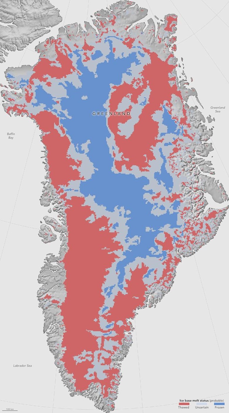
NASA has created the first map of the bottom of the Greenland ice sheet, showing which parts have begun thawing and which remain frozen as ever. This is the first time what's underneath the surface of the massive block of ice has been mapped, because the only access scientists have to it is a few bore holes. They've been trying to find out what's going on underneath for a long time, since it's essential for predicting the sheet's movements in the future. "If the ice at its bottom is at the melting point temperature, or thawed," said NASA Goddard glaciologist and team leader Joe MacGregor, "then there could be enough liquid water there for the ice to flow faster and affect how quickly it responds to climate change."
See, the ice sheet is in the Arctic, which is believed to be rapidly warming up, so it's vulnerable to climate change. And since it covers around 80 percent of the country's surface, global sea levels could rise by 24 feet if it were to melt.
In order to conjure up the map, NASA had to combine four different methods:
- The team studied results from eight computer models that predict bottom temperatures, which are tens of degrees warmer than temp on the surface.
- They looked at the ice sheet's layers detected by the NASA Operation IceBridge aircraft's radars.
- They examined the ice surface speed measured by satellites. The team then determined whether it's exceeding the max speed at which it could flow and still be frozen and anchored to the rock underneath.
- They looked for rugged parts on the sheet's surface that indicate ice sliding over a thawed bed using images taken by the Moderate Resolution Imaging Spectroradiometers on the NASA Terra and Aqua satellites.
The result? As you can see below, NASA still didn't get enough data to come to a conclusion for a third of the ice sheet. However, they gathered enough to determine that the southwestern and northeastern areas are already thawed, while the central and western areas remain frozen.