What we're using: Google Maps while lost in Japan
The company's maps and directions keep getting better.

This month, Associate Editor Mariella Moon humblebrags about her vacation to Japan. But that's not what she's going to discuss. Hailing from a country where Google Maps is lacking in detail (and metro details), she didn't expect much. However, even after installing several rival map and guidance apps, it turned out that Google knew best when it came to directions in Tokyo's spaghetti subway — and even offered a price estimate. The mapping service is moving fast, but it also brings into focus all the work Google still has left to do elsewhere.

Mariella Moon
Associate Editor
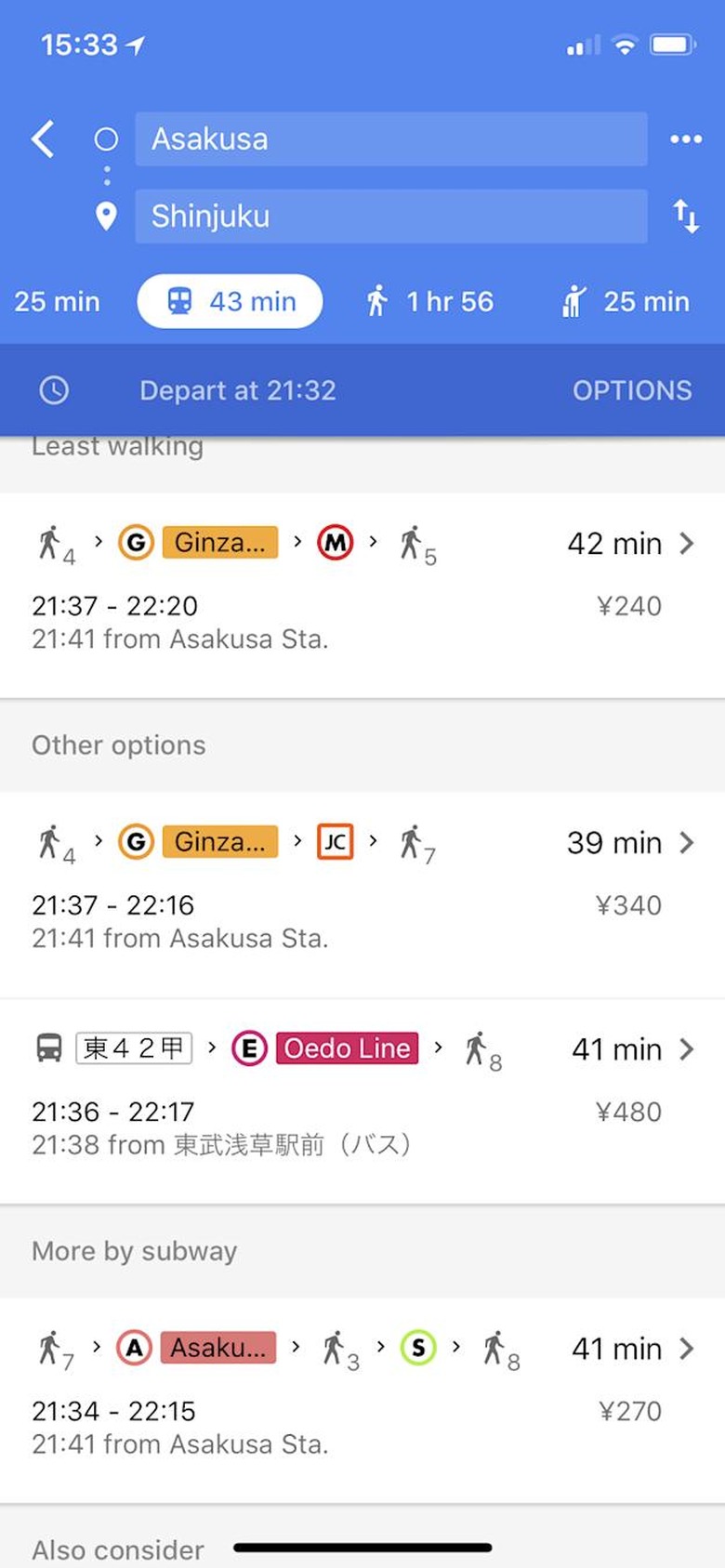
I've wanted to go to Japan for ages, but the prospect of navigating such an extensive and complex train system was daunting — especially since I'm the type who gets lost even going to places I've been to a million times before. After I spent hours upon hours familiarizing myself with frequently recommended Japan navigation apps and websites like Hyperdia, I felt more than ready to take on some of the busiest train stations on the planet. When I got there, though, I didn't touch any of them — all I used was Google Maps.
I've been conditioned to ignore Google Maps, since it's not always helpful (or accurate) where I live, in the Philippines. Admittedly, it has become a lot more detailed in my country over the years. I now see establishments in places that used to show only unmarked land. Granted, some of them don't actually exist, but that's what you get when anyone can add a business listing. It now shows shops inside malls, and a few years ago it finally got Street View.
I now also see public transit options when searching for directions around Manila. However, it's still not always reliable, due to the types of public utility vehicles we have available. It can't track every bus when they don't follow regular schedules, and it definitely can't tell you when the next jeepney or tricycle will pass by. For instance, it suggests I walk a few kilometers to get to my local market instead of riding a jeepney. It also wants me to travel to the next city to ride a bus for a faraway province when I live near a terminal with direct buses going there. The transit options it presents do include trains, but since they break down quite often, don't expect those departure times to be correct.
Mariella Moon
In Japan, though, Google Maps became my staunchest ally. It offered clear, easy-to-follow routes that helped me make sense of the chaos, even during Tokyo's infamous rush hours. The country has quite a few railway companies, so knowing which line to look for is kinda important if you don't want to wander around labyrinthine stations for hours. Google Maps also shows shops inside train stations (for each floor!), marks every crosswalk and even has a timestamp for when a bus you can take will arrive if there's a stop close by.
While Google Maps might never be as detailed or as accurate here because of the way our transportation system works, I'm crossing my fingers and hoping that it continues to improve. It was also pretty useless in Japan a decade or so ago, after all. And I hope Google polishes Waze while it's at it — the navigation app has taken me down cul-de-sacs far too many times.