hiking
Latest

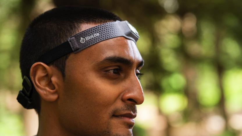
BioLite’s HeadLamp 330 is listed at its lowest price yet, $40
It isn't just laptops and phones that are getting marked down for Black Friday. Some of our favorite outdoor gear will be discounted, too.
Ask Engadget: What are the best outdoor navigation apps?
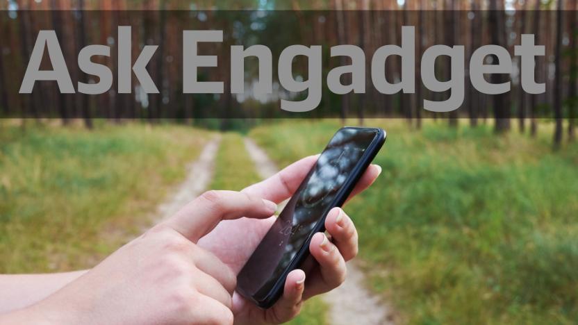
The support shared among readers in the comments section is one of the things we love most about the Engadget community. Over the years, we've known you to offer sage advice on everything from Chromecasts and cameras to drones and smartphones. In fact, our community's knowledge and insights are a reason why many of you participate in the comments. We truly value the time and detail you all spend in responding to questions from your fellow tech-obsessed commenters, which is why we've decided to bring back our "Ask Engadget" column. This week's question asks about outdoor navigation apps. Weigh in with your advice in the comments -- and feel free to send your own questions along to ask@engadget.com! I've been doing a lot of hiking and walking outdoors, as well as some bird watching. But Google Maps has turned out to be really unhelpful when it comes to walking directions, especially when it comes to trails in parks. What is the best app for navigating outdoors?
How to give your hike a high-tech upgrade
Here's all of the gear you need to take your hiking game to the next level.

In case of emergency: The tech that might save you
Nature is beautiful, but it can also be unpredictable and dangerous. Here's the gear that might save you when you're spending hours hiking, camping or adventuring outdoors.
Engadget’s guide to all the outdoor gear you need this summer
If you're reading this at a desk, take a moment to stand up and locate your nearest window. You might see a street, a garden or even some fields. Whatever your current view, you are peering at the edge of the great outdoors, and adventure is beckoning. But this is Engadget, and we believe there aren't many things in life that a sprinkling of gear can't improve -- and that includes the time you typically reserve to escape a screen (ironic, we know).

Getting lost in the woods isn't so bad with this tech
A walk through the woods. It sounds wonderful. Birds chirping, deer frolicking off in the distance, the majesty of the trees, the opportunity to get lost and drink river water that ties your stomach in knots. Hiking doesn't have to be a combination of pure joy and fear of succumbing to the dangers of being outside.

Cooking in the great outdoors
Camping is a wonderful way to get away from the hustle and bustle of the overly stimulating modern world. If you're fortunate, you'll venture beyond cell coverage for a distraction-free trip into the wild. It's wonderful... until you realize you can't get a pizza delivered.

Spyglass: A full featured nav app for outdoor enthusiasts
Spyglass (U.S. $3.99 on sale) is a really complete GPS toolkit for people spending time outdoors or doing off-road navigation. Features are numerous; among them are a heads-up display, a high quality compass with map overlays, a gyrocompass, speedometer, altimeter, astronomical object finder, a sextant, inclinometer, and angular calculator and more. The app makes use of every sensor in your iOS device in a simple to use package. Waypoints can be saved and navigated to by following a simple pointer. Spyglass can track multiple destinations at the same time, and display distances, direction, azimuth, elevation and ETA. A rangefinder measures distances to distant objects. The app can utilize your camera to provide photos with data overlays. Hikers and others going off-road will really be excited about this app. It has a myriad of functions all wrapped up in one place. I tried the app and found it useful, even in urban life. You won't get the most from the app without reading the instructions, and there are some nice videos available as well. This isn't a typical navigation app with streets and hamburger joints; it's a sophisticated tool for finding your way when there are no roads or obvious checkpoints. It's customizable, even to the colors of the displays and the filters over your live picture -- for use at night, for example. I do a lot of landscape photography that involves some hiking and car locating. Spyglass was a trustworthy companion for that endeavor, including estimating my altitude and distance to destinations. Getting back to my car was easy, just a matter of following an on-screen pointer. If Spyglass interests you, there are online videos and a manual you can check before you buy. Spyglass needs iOS 6.1 or later, it's universal and therefore friendly with all iOS hardware, and it's optimized for the iPhone 5. Recommended.

Maps 3D PRO is a best in class GPS/Nav app for outdoor enthusiasts
There are so many navigation apps available now that one can wish for a navigation app just to find one in the app store. Most are variations on a theme; get from point A to point B efficiently, with information about stops along the way. Maps 3D PRO (U$4.99) is a entirely different animal. Designed for hikers, cyclists, skiers and outdoor activities, the app provides 2D and 3D map views that show details of terrain and altitude. The app can give a generic and not-too-detailed view of anywhere in the world, but the real power comes when you select an area and download any of 11 types of maps for that area. That means you can use the app with no data service, so it's perfect for those out of the way places. Of course GPS works anywhere, so your position will be right on the detailed map. Maps include detailed NASA satellite views, 3D topographic maps, Open Street Maps for city navigation, USGS maps and more. It's a really strong selection. Once you have your maps installed, you can add up to 20 waypoints and Maps 3D PRO helps you follow a trail, road, or any route you select. You can find locations by searching, and view the terrain in 2D or 3D. The 3D is beautifully rendered, and you can zoom and rotate. When you are on your way, the app displays distance travelled and current and average speeds. A logger function records your position and altitude. Your tracks can be shared via email, Facebook and Twitter, and you can load routes via iTunes, EveryTrail, email or Dropbox. It's a great app for geocachers, horseback riders, cross country skiers, and anyone else who loves being outdoors. I've noted some good photo-spots, and the app gives me an excellent view of the surrounding terrain. I haven't seen a better app for outdoor hiking or activities. It's well thought out, and easy to use in the field without a bunch of confusing options or menus, yet it is powerful. For a person wanting to get beyond street maps and get off-road, this is a perfect app, yet it has excellent city details as well. The only thing I would change is where the search function sits -- it's one menu below the main screen, and I'd love for it to be located on the main screen. Maps 3D PRO would be a great gift for the outdoor-type person in your life, or a great gift for yourself. Over the holidays you may indulge in skiing, cycling or hiking, and this is a terrific app for those activities. Maps 3D PRO is a 22MB download, but data requirements grow as you download those detailed maps. The app requires iOS 7 or later, and it is optimized for the iPhone 5. Highly and enthusiastically recommended!

This app helps you find strangers to hike with, which might be a bad idea
Walking into the wilderness with a complete stranger might sound like the beginning of a slasher movie, but that's exactly the point of hikewith.me, an upcoming app that lets outdoor enthusiasts connect and meet up for their own adventures. The app uses a questionnaire system similar to some dating apps, only instead of matching you with potential mates based on relationship metrics, it matches you with other nature lovers to schedule co-op hiking dates. What's particularly unique about hikewith.me is that it emphasizes all communication take place outside of the app itself. There's no way to carry on a conversation with your matches from within the app, which may or may not be a great idea. On one hand it's smart to push people to interact face-to-face and make plans for the outdoor activities the app revolves around, but on the other hand, if the first time you converse with a stranger comes just before walking into the woods or up an mountain with them, your chances of ending up on a forensic murder show might spike a bit. via Springwise

Discover new adventures with Adidas Outdoor Magazine
If your idea of an outdoor adventure is riding your bike through the park, or taking a long leisurely walk then Adidas Outdoor Magazine app is not for you. This free iPad only app appears in your Newsstand and presents you with real adventures in paragliding, mountain climbing, slack lining, kayaking, and loads of other adrenaline rushing activities made for the true extreme outdoors enthusiast. Adidas Outdoor Magazine is published four or five times a year. Each issue contains about a half dozen in-depth articles detailing specific adventure activities plus interviews with professionals and other everyday adventure seekers like yourself. Users will find some wonderful photos and thrilling videos with each article. The videos are often worth a look just on their own. Additionally Adidas runs brief articles promoting some of its product line. The current October 2014 issue contains stories about a variety of climbing expeditions. You will find a story about a mountain climbing adventure in Oman and an article revealing the sense of happiness a couple felt after scaling a 2800 foot stone wall that climbs straight up out of the Brazilian jungle into the bright sunlight, plus others and a column by experienced mountaineer Reinhold Messner detailing his attempts over the last four decades to climb some of the world's most difficult and dangerous peaks in the middle of the winter while facing rocks covered in snow and ice, 50 mph winds and temperatures that hovered around forty degrees below zero. The Adidas Outdoor Magazine app also has a library of back issues. Users get free access to all the issue back to early 2012. In these issues you will find even more exciting adventures detailed in words, pictures, and video. So what if you aren't a big time thrill seeker who can't wait to be walking over a single line anchored a thousand feet over a gorge or to be rushing down a raging river with nothing to protect you but a thin shelled kayak and your own skills. I certainly fit into that category but I found the articles and pictures contained in this app to be fascinating. The Adidas Outdoor Magazine app articles are well written and bring an element of the excitement the adventurers feel right to the readers and as I mentioned before the photos and videos are top notch. Adidas Outdoor Magazine app is worth a look so you can live vicariously through the adventures of others. One point to note though. While some of the content downloaded quickly, others were very slow and some stopped during the download. I received a server error message a couple of times so it might have been a server issue the day I checked out the app.

Group GPS is a great app for hikers, bikers, and those wanting to stay in touch
Group GPS (free) is one of those "Gee, I wish I had thought of this" apps. To get started, you sign up for a free account by supplying a user name and an email address. Create an activity, like 'bike race' or 'desert hike,' and send an invitation to your friends. If they don't have Group GPS, they get a text message with a download link. When everyone responds, you'll see each person identified on a map, and their movements update as they move around. I can think of lots of applications, like meeting friends at a location and seeing that they are on the way, finding people at a concert, car rallies, almost anything. When the activity is done, just stop Group GPS and you're removed from the activity. You can also pause the app anytime and return. The map can be zoomed in for more detail on a single position, or zoomed out to see everyone else's location. The Group GPS account was easy to sign up for. It doesn't matter where the other people are; even if they are in another state, you'll see the map stitch to fit everyone, and you can watch your group converge. Apps like Glympse are perfect for letting people know where you are and your ETA. Group GPS lets everyone in a group know where everyone else is. In testing the app, I noted that the position updates aren't in real time, more like once a minute or so. This was likely done by the developer to preserve battery life, although I'd like to see an option to step up the update frequency. The app is ad-supported, but the ads are not invasive or distracting. Having said that, I'd be glad to see a paid version with no ads and a few new features, like being able to message the group from within the app. If you'd like to see the app in action, you can check out a video on the developer website. A similar free app is FastWhere, which also does location sharing. Group GPS is a really great idea, and I think most people will find some good uses for it. The app requires iOS 7.1 or later. It's not universal, but it is optimized for the iPhone 5.

Generate power to recharge gadgets while grilling with this camp stove
BioLite has been recharging smartphones, action cams and GPS units via camp stove fire since 2012, but now it's offering a larger model that will grill enough grub to feed your entire crew. The BaseCamp stove offers the same heat-to-electricity conversion, but with a much larger cooking surface for grilling dinner (up to eight burgers at a time) for more than just a pair of weary hikers. The built-in power pack has been upgraded as well, generating 5W and storing power for juicing up devices during dessert alongside a UI that gauges temperature and displays the amount of electricity being generated. Need to use a pot to boil water? That cooking surface can wrangle the flame for optimal output with the flip of a lever. If all of that sounds too good to pass up, units are set to ship in September and you can one for $299 during the company's Kickstarter effort.

TUAW at Macworld/iWorld 2014: Kamino
Kamino is a new free app that is making its debut at Macworld/iWorld 2014. Described as an "urban discovery app", the idea behind Kamino is that people who enjoy walking or hiking around their urban homes can capture those hikes and share them with others. If you're visiting a city on vacation or just want to learn more about your own surroundings, Kamino can help to provide you with some good walking ideas. We caught up with the Kamino team in the Appalooza area at Macworld/iWorld for a quick video interview about what the app does.
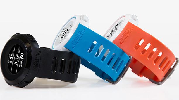
Magellan's Echo smartwatch now tracks your golf and skiing adventures
Magellan reckons that many smartwatch buyers are fitness mavens, and it's catering to that health-minded audience today with a big upgrade to its Echo Smart Sports Watch. The iOS-compatible wristwear now tracks data for a much wider range of activities beyond running, including golf, hiking and skiing; you won't need a dedicated device or special watch apps to get stats for that black diamond ski run. As before, the Echo offers basic control over both music as well as athletics apps like Strava and Wahoo Fitness. If you're interested giving the upgraded watch a try, you can pick one up today for $149 by itself, or $199 paired with a heart rate monitor. Android users should get Echo support sometime early this year.

Google Trekker goes to the Grand Canyon, takes Street View souvenirs back home
You might remember Google's unveiling this spring of the Street View Trekker, a seeming cross between a backpack and Van de Graaff generator that lets the mapping team produce 360-degree imagery where even trikes dare not tread. The portable camera ball is just going on its first trip, and Google has chosen the most natural destination for a novice tourist -- the Grand Canyon, of course. Staffers with Trekkers are currently walking trails along the South Rim of the canyon to provide both eye-level points of reference for wayward hikers as well as some breathtaking, controllable panoramas for those who can't (or won't) make it to Arizona. Once the photos make it to Street View sometime in the undefined near future, it'll be that much easier to turn down Aunt Matilda's 3-hour vacation slideshow.

Contour's new mount, watersports kits help bring its cameras with you in the water, snow or dirt
As Contour continues to do battle with GoPro over the action-sport POV camera market, its latest offensive centers around prepackaged activity-specific mount kits that should make it easier for customers to pick one up and go. Also new is an all-in-one ContourRoam watersports kit that includes the HD camera and waterproof case that's capable of keeping it dry at depths of up to 60m. The mount kits include sets for skiers, cyclists, motorcyclists, hikers and an all purpose helmet mount kit. All of these are available starting today on the company's website and at select retailers, with the mount kits going for between $59 - $99 and the Roam Watersports kit for $249. We appreciated the Contour+'s sleek package in our head to head test with the Hero 2 last month and the addition of these packages should help it compete on price and ease of use right out of the box. The specific details are in the press release after the break and pictures of each set are in the gallery below, assuming your hobbies are exciting enough to merit recording, of course.

Columbia's GPS Pal app for Android and iOS logs your hikes, geotags memories (video)
Move over, My Tracks -- you've got serious company. Google's own adventure tracking app just got majorly one-upped by a company that also happens to make heated jackets. Columbia's just-launched GPS Pal app is not only available on both Android and iOS, but it's actually designed to be used with a user account so that activity logs are neatly housed in a searchable, organized portal. It's free to download, and aside from monitoring your hikes and treks via GPS, it also syncs photos, videos, and trail information to a web journal automatically, complete with pinpoint geotagging information on each piece of media. As for data points? It'll keep track of elevation changes, current speed and distance traveled, and it makes sharing said trips to social networks quite the lesson in simplicity. Naturally, you'll need a data connection in order to upload media while on the trail -- something that's often hard to find -- but at least the app tells you how poor (or great) your GPS signal is at all times, which is all that's required to keep track of your actual steps. Head on past the break for a promo video, or hit the links below to grab it for your platform of choice.

National Parks Street View-style trails goes live, avoids the Google cars (video)
After tooling up a team of hikers with an impressive camera tripod and unleashing them on the likes of the Grand Canyon and Yellowstone Park, Nature Valley has published its fully rotational Trail Views online. You'll be able to effortlessly follow several routes across the great American countryside and for those too lazy to even click the forward arrow, there's an autoplay mode. Three different locations -- with multiple trails -- are online now and you can check out how the granola-grinding company captured it all right after the break.

Lost hiker saved by iPhone flashlight app
One time when I was day hiking Mount Washington, I took a wrong turn at the top and went down the wrong way. I raced down the mountain, but still had to navigate some rough terrain for a few hours in the dark. This was the late nineties. I had a phone, but it didn't get coverage and phones back then didn't have a flash for light. That was then, and this is now. Today, hiking in the woods is much safer thanks to improved cellular coverage and smartphones with apps. Based on this story from Jonathan Anker of HLNtv, I'm sure Christopher Tkacik of Maryland would agree. Mr Tkacik was out walking his dog on New Years Eve when he got lost in the woods surrounding Catoctin Mountain. After several hours of wandering around, he used his iPhone to call for help. He was instructed to stay where he was and wait for rescue. To help the rescue team find him, he didn't start an old-fashioned fire; he used a flashlight app as a beacon to attract them to his location. Tkacik and his dog made it out of the woods without injury, and he was home in time to keep his New Year's Eve plans.


