Street View
Latest
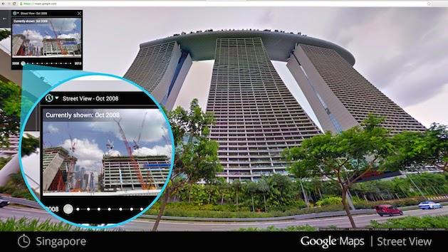
Google Street View now serves as your own personal time machine
In the seven years since Google launched Maps, it's collected a ton of imaging and location data, which we've only been able to see in its most recent form. That's about to change, however, after the company announced it's opening all of that information up, allowing you to go back and see how much each of its locations have adapted during that period. Starting today, Google says it will begin rolling out the new feature across its desktop Maps service, adding a new clock icon to Street View images. Once clicked, you can move a slider and select the different thumbnails of a location in a particular space in time. You'll see skyscrapers go up, houses come down, and maybe even witness the rebuilding efforts of a community affected by a natural disaster. There's no word on whether it'll make its way beyond the desktop, so for now you'll likely only be able to procrastinate from the comfort of your home computer or office.

Safely tour Marseille's back streets after dark with Google Night Walk
The streets of Marseille are beautiful, but have something of a reputation for being a bit stabby. Fear for your safety shouldn't prevent you from seeing the sights, which is why Google and Radio Grenouille have teamed up to create Night Walk. Combining high-res Street View shots with audio from the city, you'll now be able to wander the back alleys of the Cours Julien with the warming gallic tones of Christophe Perruchi by your side. [Thanks, Daniel]

Google's Trekker project brings beautiful Hawaii imagery to Street View
After launching Street View Trekker last year, Google is now starting to show us what we can expect from its loaner program. What you see above are some pictures from the Hawaii Tropical Botanical Garden, which were taken by Google's first Trekker partner, Hawaii Visitors and Convention Bureau, and added to Street View as part of the company's imagery project. The search giant says there's a lot more where that came from too, including beaches, historical sites, hiking trails and parks. And with the summer right around the corner, this is a perfect opportunity to virtually explore The Islands of Aloha before booking your next vacation.

Google adds the 'Polar Bear capital of the world' to Street View
One of the more immediate effects of climate change is that the icy habitats of the Polar Bear are very rapidly evaporating. In an attempt to connect people more directly to the issue, Google and Polar Bears International have teamed up to bring the evidence straight to Street View. Attaching a Trekker Backpack to the charity's specially adapted vehicle, the pair have mapped the frozen tundra of Churchill, Manitoba, otherwise known as the "Polar Bear capital of the word." In addition to the harsh landscape, the team have captured a few of the most famous four-legged residents, so if you fancy getting up close and personal with nature, head down to the source link and get looking.

Google's reasonably priced Street View car tours Top Gear's test track
Like swerving bends and screaming "powerrr!" as much as you dislike electric vehicles? Imagine your delight, then, when you learn that Google and the BBC have teamed up to send one of the former's street view cars around Dunsfold Aerodrome -- more famously known as Top Gear's test track. As you zoom around the lap, you'll notice a Mercedes-Benz SLS AMG popping up by your side, ably driven by the show's tame racing driver. Some say he's a clone of Justin Bieber gone right, and that he prefers to think of Dunsfold Aerodrome as the place where they shot the Miami Airport sequence of Casino Royale. All we know is that he's called The Stig.

Street View update maps North America's biggest parks and monuments
Google's Street View may have already taken us on a virtual tour of some US national parks, but its total number of natural sites now sits at an impressive 44 US and Canadian locations. With permission from the US National Park Service and Parks Canada, the search giant's cars, trikes and backpack-worn Trekker units have mapped some of most picturesque and historical sites in North America, providing us with new 360-degree views of Mount Rushmore, the Alamo Mission in Texas and the crystal-clear lakes of Banff National Park, to name but a few. All of these different locations -- with multiple trails -- are online now and you can check them out by hitting the source below.

Google's Street View maps the watery roadways of Venice
Google's Street View has taken us all the way up (to the Burj Khalifa) and all the way down (to the Great Barrier Reef), so where else is there to go but the world's most romantic city? That's right, the search giant has taken its backpack-worn Trekker units to Venice, letting you explore its canals, tight streets and hundreds of connecting bridges from the comfort of your home or office. In its behind-the-scenes look, Google lets you see how the city has changed since 1838 with the help of a 175-year-old street map and explore locations that inspired famous works of art. If punting was never your thing, hit up Google Street View to begin your personal guided tour -- minus the unique odor.

Google's Street View tour of Gatwick Airport is its biggest European indoor map yet
If you're one of those people who wants to know exactly what to do and where to go when you get to an airport, Google's latest Street View update might come in handy. As part of its biggest European indoor mapping project so far, the search giant took its trolley units to Gatwick, the UK's second busiest airport. The resulting 2,000 images were stitched together to create a virtual representation of its North and South terminals, allowing you, and an estimated 34 million yearly passengers, to familiarize yourself with its maze of connected corridors and multitude of shops and restaurants. Hit up Google Street View to begin your not-so-personal guided tour, but bear in mind you won't make it onto the tarmac and any duty free deals that you spot in stores may no longer apply, because the footage was collected in June.

Google Street View can now take you on a tour inside a naval submarine
Ever wonder what it's like to wander the narrow corridors of a 50-year-old Oberon-class British submarine? Well, you can now embark on a digital tour of the HMS Ocelot via Street View, which has become the first submersible to be fully documented by Google. Even without its backpack-worn trekker units, the company has mapped-out the Ocelot's complex control room, restricted sleeping quarters and even its six torpedo tubes, which have thankfully been out of service for more than 20 years. It also lets you take a tour of the dockyard from which the submarine was launched. Hit up Google Street View to begin your personal guided tour, just be sure to mind your head when navigating those hatches. [Image Credit: wimbledonian, Flickr]

British canal boaters, welcome to Google Street View
In the same way that you can't really call The Hitchhikers Guide to the Galaxy a trilogy any more, Google's once again stretching the definition of a street. The company has loaned out one of its backpack-worn trekker units to the UK's Canal and River trust, which will document 100 miles of the country's waterways for Street View. Users will be able to tour London's Regent's Canal, the Bingley Five Rise and the Stoke Brueme blacksmiths on the Grand Union Canal. Just remember folks, even if you're touring from the comfort of your laptop, it's not a proper rambling holiday unless you bring a packed lunch and a flask of weak lemon drink.

Google Earth 7.1 for iOS now includes Street View
Google yesterday updated its Google Earth app for iOS to version 7.1.1. While previous updates to Google Earth have simply come with boring "performance improvements and bug fixes," this is an update actually worth exploring. You see, the latest iteration of Google Earth finally includes Street View. A post on the Google Maps blog reads: Have you ever wanted to take a tour of Stonehenge or retrace the steps of Christopher Columbus? With the addition of Street View to Google Earth for mobile devices, you can explore many sites from street level right on your mobile device. And with the new streamlined interface, a simple click of the Earth logo in top left will give you quick access to more information through layers like Panoramio Photos and Wikipedia. Just in case you decide to visit these places yourself, Google Earth's improved directions enable you to visualize step-by-step transit, walking and biking directions in full 3D. What's more, Google notes that the updated version of Google Earth for mobile is now available in more than 100 countries across the globe. The full changelog reads: Google Maps Street View: With Street View, you can explore the world at street level. Improved directions/search: Updated directions let you can visualize transit, walk, bike and drive directions in 3D while update search result list will let you browse search results quickly. Improved interface: Easily browse and enable different layers through use of new left hand panel. You can check out the update on iTunes over here.

Google Earth update brings Street View and streamlined interface to iOS
Google's taking the iOS version of its Earth mapping app up to 7.1. The update brings a few new features, including, most notably, the addition of its Street View imagery -- following a similar update to the Android version. Also on the docket are improved transit, walking and biking directions, which can be viewed in 3D. The interface has been streamlined too, with a number of informational layers like Wikipedia located under a handy Earth logo in the top left off the app. The release of 7.1 also marks the app's availability in more than 100 countries. More info on the update can be had in the source link below.

Watch how Google brought Street View to the Burj Khalifa (video)
Street View's fine for navigation, but we're sure plenty more people use it just for their armchair tourism. Google has now turned its attention to giving thrill-seekers a chance to gaze out from the top of Dubai's Burj Khalifa, the world's tallest building. Using Trekker backpacks and trolleys, it took the Googlers three days to capture the images from both the viewing gallery on the 124th floor and the window cleaning gantry on the 80th. Curious to experience some of that vertigo for yourself? Video's after the break.

Google Maps brings you to Everest, Kilimanjaro with all your toes intact
Living vicariously just got a bit more exciting. Google Maps had added some of the most famous (and highest) mountains in the world to Street View. The list includes Aconcagua, Kilimanjaro, Mount Elbrus and Everest Base Camp -- four members of the Seven Summits, letting you explore some of the of the highest points on Earth without the aide of a breathing apparatus. According to Google, the shots were captured with the help of a tripod and a fish-eye-sporting digital camera. All of the aforementioned mountains can be reached in the source link below -- or with the assistance of a good support team.

Wii Street U now available, free for a limited time
Wii Street U, the console's stylized, augmented version of Google Maps, is now available for the system. As was previously announced, the app allows users to navigate to a location on Google Maps, and then use the GamePad (and its various motion sensors) to view the Street View data for said location in a semi-realistic, one-to-one fashion.

Google Maps with Street View arrives on Nintendo Wii U in Japan, free for a limited time
True to Iwata-san's word, Google Maps with Street View is indeed making its way to the Nintendo Wii U this month. Word of the mapping service's impending arrival first came this past December, but at the time, no mention was made of availability outside of a vague January 2013 launch. As we learned later however, it was pushed back another month but Wii Street U Powered by Google is live in Japan, and will be free through the end of May. After that, there will be a fee for access to the service's Panorama View-like feature, which leverages the GamePad for 360-degree perspectives. Of course, you can also peruse both plain and Street View maps from the TV, but that kind of diminishes the gimmicky point of the second screen controller. (Also, you could just use a laptop, tablet or phone for Google Maps -- just sayin'.) There's no word on US release plans or potential pricing, but it's worth noting the TVii app that's free here carries a nominal 100 yen charge in Japan. Hit the source link for an interview with the team behind bringing the app to the console.

Google: it's cool, guys, we didn't run over a donkey
Before you go hurling insults like "donkey killer" at a multinational software giant, it's probably best to get the other side of the story. In spite of visual evidence to the contrary, Google insists that it did not, in fact, run over a burro while gathering shots for Street View. In fact, the company has laid the whole thing out Zapruder-style over on its Maps blog, highlighting how the donkey, which appears to be dead, gets up and walks away, after lying down in the road, "perhaps enjoying a dust bath." So, rest assured, Botswana's equidae are safe from Google's reach -- for now.

Google Trekker goes to the Grand Canyon, takes Street View souvenirs back home
You might remember Google's unveiling this spring of the Street View Trekker, a seeming cross between a backpack and Van de Graaff generator that lets the mapping team produce 360-degree imagery where even trikes dare not tread. The portable camera ball is just going on its first trip, and Google has chosen the most natural destination for a novice tourist -- the Grand Canyon, of course. Staffers with Trekkers are currently walking trails along the South Rim of the canyon to provide both eye-level points of reference for wayward hikers as well as some breathtaking, controllable panoramas for those who can't (or won't) make it to Arizona. Once the photos make it to Street View sometime in the undefined near future, it'll be that much easier to turn down Aunt Matilda's 3-hour vacation slideshow.

Visualized: Google Street View car fleet gets ready to conquer (and map) the world
Ever wonder how Google can make such grandiose claims for the sheer amount of Street View imagery it collects? Here's how. Google's Masrur Odinaev has posted a snapshot of a central mapping car parking lot that shows dozens of the camera-equipped Subaru Imprezas amassed ahead of future runs. While it already represents more Street View cars in one place than anyone outside of Google would normally ever see, what's most impressive is remembering that this addresses just a portion of the entire vehicle mix -- aside from the local cars you don't see in the photo, there are extra units worldwide providing street-level coverage alongside tricycles and underwater expeditions. Odinaev's look reminds us just how much effort is needed to make Street View a common feature -- and that there are are legions of Google staffers whose low-profile work goes a long way towards making our navigation easier.

Google's 'biggest ever' Street View update doubles special collections, refreshes 250,000 miles of roads
Google's eponymous mapping system has received plenty of good press recently, but the company knows it can't take some time out to enjoy its position. As such, Mountain View's pushing out what it calls the biggest update to Street View it has ever undertaken, refreshing 250,000 miles of road imagery and doubling the amount of special collections. Some of the new attractions you can visit from the comfort of your home include Catherine Palace in Russia, Stanley Park in Vancouver and Singapore's Fort Canning Park. We're thinking we might have to use the system the next time we fancy a cultural visit -- after all, we'd save a pile on airfares.


