Google Earth
Latest
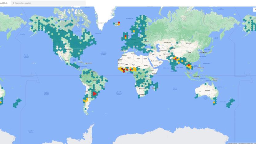
Google’s sustainability features now include an EV buyer’s tool
It also has an expanded Flood Hub and home energy comparisons.
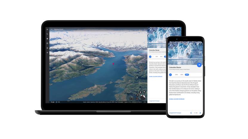
Google Earth's biggest update in years adds free 3D timelapse videos
Google Earth is getting its biggest update to the service since 2017. It's adding 3D timelapse videos that anyone can watch and download for free.

Google Earth finally works on Firefox, Edge and Opera browsers
When Google ditched its desktop Earth app in favor of a web-only experience, it said it was "almost ready" to work on Firefox and other browsers. That was nearly three years ago, but Google has finally delivered on that promise, as Google Earth now works not only on Firefox, but Microsoft Edge and Opera too, the company announced.
Google's world is your next wallpaper
Google Earth is arguably the best product Google has ever created because it allows anyone to explore our planet (and beyond) with ease. However, you may not know that Google also has an app called Earth View that contains some of the best curated images you can find on the app. Google recently announced that it has updated this collection with over 1,000 new images (for 2,500 in total) and introduced new search tools to find that perfect wallpaper background.
Google Earth adds views of outer space on mobile
When you zoom out all the way on Google Earth for the web and Pro on desktop, you get a view of our planet with stars in the background. Unfortunately, that starry background is replaced with plain black when you use the program on mobile -- until now, that is. The tech giant has updated the Google Earth app with the ability to display the starry universe on phones and tablets, thanks to the fact that mobile devices are now more powerful than ever.
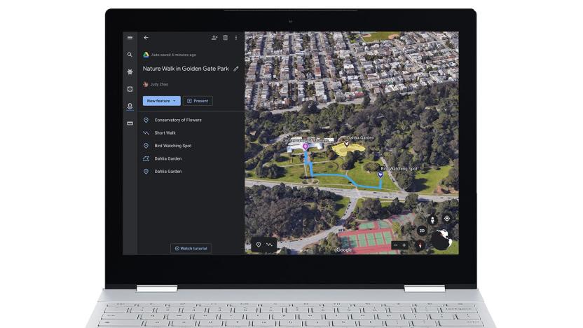
Google Earth's new creation tools help you tell stories
Google Earth offered community tour-building features for a while, but the attention shifted to professional "Voyager" stories after the big redesign in 2017. Now, however, Google is swinging its attention back to stories from everyday users. It's introducing creation tools in Google Earth's web version to help you tell your own tales. You can draw place markers, lines and shapes, attach your own media (including full-screen slides) and choose specific 3D or Street View angles. Chain these items together and you can create tours that reflect your personal narrative, or even the 'hidden' history that doesn't always show up in textbooks.
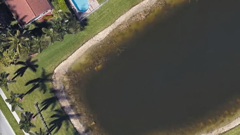
Decades-old missing person case solved with Google Earth photos
The body of a man who had been missing for nearly 22 years was found this week thanks to Google Maps, according to the Sun Sentinel. Remains of 40-year-old William Moldt turned up in a pond located behind a housing development in Wellington, Florida after one of the residents of the neighborhood spotted what appeared to be a vehicle in the water behind his house while looking at Google's satellite images. Police retrieved the remains of the body and positively identified it as Moldt.
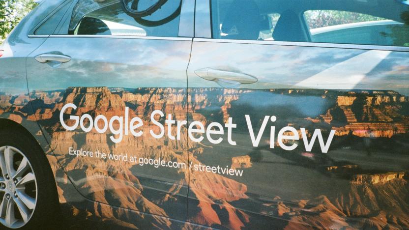
Google shares its Street View air-quality data with scientists
Google is releasing air quality data it collected from California's Bay Area and Central Valley with its Street View cars, part of a larger effort by the company to track pollution around the world. The data was captured over the last three years and includes measurements that were taken after wildfires in the Wine Country region and from the agricultural regions of Central Valley. While the full dataset isn't available to the public, scientists can request access through a form.

Where on Google Earth is Carmen Sandiego?
If you're an '80s or '90s kid, you might remember searching the globe for the evil villainess Carmen Sandiego and her fleet of henchmen. You'd follow clues (from what was likely your first PC) based on foreign currencies, flags, languages and landmarks to track the international menace -- all without leaving your family's "computer room." Now, Google Earth is reviving the search with a series of Carmen Sandiego games.

The Morning After: Thursday, November 17, 2016
We put the 4K-ready Chromecast to the test, saw increasingly less snow around the US, and gawp at the first hybrid Mini -- as well as a whole bunch of new cars coming out of the LA Auto Show. There's also the discovery of a "Watch Dogs 2" character that has fully rendered sex organs for no apparent reason whatsoever. Not just another Thursday.

Google Earth 7.1 for iOS now includes Street View
Google yesterday updated its Google Earth app for iOS to version 7.1.1. While previous updates to Google Earth have simply come with boring "performance improvements and bug fixes," this is an update actually worth exploring. You see, the latest iteration of Google Earth finally includes Street View. A post on the Google Maps blog reads: Have you ever wanted to take a tour of Stonehenge or retrace the steps of Christopher Columbus? With the addition of Street View to Google Earth for mobile devices, you can explore many sites from street level right on your mobile device. And with the new streamlined interface, a simple click of the Earth logo in top left will give you quick access to more information through layers like Panoramio Photos and Wikipedia. Just in case you decide to visit these places yourself, Google Earth's improved directions enable you to visualize step-by-step transit, walking and biking directions in full 3D. What's more, Google notes that the updated version of Google Earth for mobile is now available in more than 100 countries across the globe. The full changelog reads: Google Maps Street View: With Street View, you can explore the world at street level. Improved directions/search: Updated directions let you can visualize transit, walk, bike and drive directions in 3D while update search result list will let you browse search results quickly. Improved interface: Easily browse and enable different layers through use of new left hand panel. You can check out the update on iTunes over here.

Google Earth update brings Street View and streamlined interface to iOS
Google's taking the iOS version of its Earth mapping app up to 7.1. The update brings a few new features, including, most notably, the addition of its Street View imagery -- following a similar update to the Android version. Also on the docket are improved transit, walking and biking directions, which can be viewed in 3D. The interface has been streamlined too, with a number of informational layers like Wikipedia located under a handy Earth logo in the top left off the app. The release of 7.1 also marks the app's availability in more than 100 countries. More info on the update can be had in the source link below.

Sign-up page for revamped Google Maps shows off plenty of new features
Just hours before its I/O event, Google has apparently had a little accident: the sign-up page for "the new Google Maps" briefly went live, revealing a slew of extra details about what's coming in the rumored refresh before quickly being pulled. Droid-Life managed to grab some screenshots, including the one above, which gets to the heart of what Google is trying to achieve. The central idea is that Google will create maps tailored to the kind of information you're looking for, using a "smarter search box" to highlight just the "things that matter most," whether those be flights, ground transport or the new Earth View that integrates directly with Google Earth without the need for a plug-in. According to the leaked sign-up screens, the bringing together of all Google's data will result in layers of information that reach "from outer space down to the streets" -- but there's still no evidence about how (or whether) this might work on mobile. Stay tuned to our Google I/O opening keynote liveblog for more.

Google updates Maps and Earth with more high-res and 45-degree images, encourages wanderlust
Google has expanded its high-res Maps and Earth offerings to cover a whopping 164 cities and 108 countries / regions, while its brand new 45-degree imagery is now available for 60 cities (40 in the US and 20 abroad) -- the list is long, so check out the source to discover all the locations. The photos are pretty stunning; highlights include a live look at the Space Needle's orange paint job for its 50th anniversary, an overhead look at Austrian bridges and an angled view of the Thun Castle in Switzerland. Now, excuse us as we stare longingly at these gorgeous vistas -- it is Friday, right?

Google draws 25 million new building footprints in Maps, shapes up your neighborhood
The fine, well labeled lines of Google Maps may show a clean layout of your neighborhood, but without buildings, it looks too much like a two-dimensional spread of undeveloped tract housing. Google's finally filling in the gaps, outlining 25 million building footprints in cities all across the United States. Residents of Los Angeles, Chicago, Miami, Houston, Detroit and other cities can now see the familiar outlines of their local stomping ground on the services' mobile and desktop maps. Most of these buildings were algorithmically generated from aerial photographs,locals can pen in their own content by using Google Map Maker to add new buildings or tag their favorite local eatery. The tweak sounds minor, but it certainly makes the standard map's criss-cross of roads look more familiar. Check out the official Google Lat Long blog below for more details.

Google offers up more high-res places in Maps / Earth, intros additional 45-degree imagery
Google's mapping offerings are getting a little bit better this week. The software giant's announced the addition of a slew of high-res aerial and satellite images for 17 cities and 112 countries / regions -- it's a long list, so your best bet is accessing the source link below to check out all of the offerings. Google's also adding 45-degree imagery in Maps for a total of 51 cities -- 37 in the US and 14 outside -- letting you check out the Leaning Tower of Pisa and the buildings of Madison, Wisconsin from an all new angle. Forget the plane tickets -- all you need for your next vacation is a browser and an overactive imagination.

Amateur archaeologist finds possible pyramids using Google Earth
While most Google Earth hobbyists are satisfied with a bit of snapping and geotagging, some have far loftier ambitions. Satellite archaeologist Angela Micol thinks she's discovered the locations of some of Egypt's lost pyramids, buried for centuries under the earth, including a three-in-a-line arrangement similar to those on the Giza Plateau. Egyptologists have already confirmed that the secret locations are undiscovered, so now it's down to scientists in the field to determine if it's worth calling the diggers in.

Google Earth adds detailed 3D imagery for Denver and Seattle, might not render the local Starbucks
Google only launched detailed 3D maps in Google Earth for a handful of cities, but it's branching out to provide that extra dimension to a wider swath of the public. Today, it's Denver and Seattle: Android and iOS app users can immediately see the dense, textured 3D City View in their respective western cities. The updates probably won't let Seattle residents spot their hometown coffee brand without going into Street View, but it will let them thread the eye of the Space Needle while their friends in Denver spin past the State Capitol. We can't help but think that Google also enjoys offering some Microsoft staffers a little taste of what they're missing.

Embracing geotagging: how to journal your trips (and contribute to Google Earth) with snapshots
Geotagging. It's not exactly a long, lost art, but it's certainly not something most folks bother to do after a trip. Avid travelers, hikers and the general outdoorsy crowd have been embracing the feature for years, though, and it's actually seeping into the mainstream without most individuals even noticing. How so? Smartphones. Given the proliferation of iPhones, Android handsets and Windows Phone devices making their way onto the market -- coupled with the explosive use of geo-minded social networks like Path, Instagram and Foursquare -- an entire generation is now growing up in a geotagged world. Phone users have it easy; so long as there's a data connection and an embedded GPS module (commonplace in modern mobile devices), there lies the ability to upload a photo with a patch of metadata embedded. Snap a shot at a national park, upload it, and just like that, viewers and friends from around the world now have an idea as to what a specific place on the Earth looks like. Solmeta N3 geotagging module review Columbia's GPS Pal app for Android and iOS Casio Exilim EX-H20G (with Hybrid GPS) review For travel hounds like myself, that's insanely powerful. I'm the kind of person that'll spend hours lost in Google Earth, spinning the globe around and discovering all-new (to me, at least) locales thanks to the magic of geotagging. It's sort of the photographic equivalent to putting a face to a name. By stamping latitude, longitude, altitude and a specific time to any given JPEG, you're able to not only show the world what you saw, but exactly when and where you saw it. It's a magical combination, and with GPS modules finding their way into point-and-shoot cameras -- not to mention external dongles like Solmeta's magnificent N3 (our review here) -- there's plenty of opportunity to start adding location data to your photos. For more on the "Why would I want to?" and "How would I best display 'em?" inquiries, let's meet up after the break.

Google Earth, Maps get new high-res aerial and satellite imagery
3D City View for iOS isn't the only update from the Google Maps and Earth team this week, they've also spruced up their services with new imagery. Fresh high-resolution aerial and satellite photos have been added for a roster of 25 cities and 72 countries or regions, ranging from Antelope Wells, New Mexico to Zimbabwe. In addition, seven international locales and 21 US cities received the 45-degree view treatment, letting you gaze at skylines from a different perspective. The maps are already available, so you can peruse new satellite images of London's Olympic Park and Village just in time for the festivities. For the full list of areas with crisper cartographic visuals, check out the source below.


