aerial photography
Latest
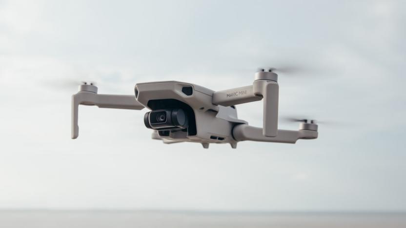
DJI's palm-sized Mavic Mini can fly for up to 30 minutes
DJI's latest drone is its lightest and smallest model ever. The foldable Mavic Mini weighs in at just 249 grams, and comes with a bunch of features designed to make drone flying and aerial photography fun and accessible to everyone, without skimping on quality. And it's so small that you needn't bother getting FAA registration for it, either.
Rachel England10.30.2019
PlexiDrone is a highly portable quadcopter for budding aerial photographers
If there was a list of features we wanted on a ready-to-fly drone, it might well read like PlexiDrone's spec-sheet. Unlike many off-the-shelf hobby quadcopters, this one comes in bits that you "snap" together when needed, making it more portable. Furthermore, it comes with a hard-shell backpack, "follow-me" functionality (which is becoming more of a thing), obstacle avoidance, and retractable landing gear (no more "legs" in shot). Perhaps two of the more understated, yet interesting features are the ability to easily swap in different cameras, and that you can simply control it with a phone. Most of us have phones, right? And, if you own anything other than a GoPro, you won't have to go buy one just to use with the drone. PlexiDrone already met its funding, but if you're quick you can still reserve yours for $700, and sit tight until April next year for delivery.
James Trew10.10.2014
New construction at Apple's North Carolina data center poses for aerial photographs
Photos courtesy of Wired reveal that Apple's new "tactical" data center at its Maiden, North Carolina facility is well on its way to completion. Captured with the help of a decidedly low-tech airplane -- a 1949 Piper PA-11 Cub Special, if you must know -- the shots feature what appear to be the facade of the $1.9 million, 21,000 square-foot structure that was outed last month. The images also show glimpses of a second 20-megawatt photovoltaic array and what may be the foundations of the complex's planned 4.8-megawatt biofuel cell plant, which will convert biogas into electricity. With Apple's upcoming Reno project getting the rubber stamp of approval, it doesn't seem like the company will run out of construction projects any time soon. Click on through to the source link for the full set of pictures and analysis.
Alexis Santos08.06.2012
Bing Maps piles on 215TB of new Bird's Eye imagery, proves it's a small world after all
Did you think Microsoft was done with Bing Maps updates after it threw a whopping 165TB of satellite imagery at virtual explorers? You've got another thing coming. The mapping crew in Redmond has thrown another 215TB of data over the fence, this time targeting its Bird's Eye views. Most of the attention is on Australia, Europe, New Zealand and Tokyo, although Microsoft has seen fit to sharpen up some of its US visuals in the process. All told, there's over 88,800 square miles covered by the new and updated aerial shots -- enough to make sure that we'll never have trouble finding Cinderella Castle at Tokyo Disneyland.
Jon Fingas07.18.2012
Google Earth 7.0 for Android brings new, super-detailed 3D maps for some cities (update: video)
Here's a bit of a surprise that slipped under the radar during the Google I/O keynote: Google Earth for Android has been updated to 7.0 to take advantage of the new 3D map technology it unveiled at another special event just a few weeks ago. As a refresher, the visuals are automatically created from 45-degree aerial imagery and can pick up 3D elements as subtle as trees. Before you go racing to your hometown to see how it looks in 3D, be aware that just a handful of cities and regions exploit that dimension. Besides San Francisco Bay, the full coverage extends to Boulder, Boston, Charlotte, Lawrence, Los Angeles, Long Beach, Portland, San Antonio, San Diego, Santa Cruz and Tampa in the US, with Rome being the lone international hotspot. If that's too few places to visit, there's always the addition of guided tours. Android users can head over Google Play to get the update today; iOS users shouldn't fret, as they'll get the new maps soon. Update: Google now has video, if you'd rather not (or can't) install the app to try it yourself.
Jon Fingas06.27.2012
Google Earth adds balloon and kite aerial imagery, invites you to contribute
Google Earth already offers quite a variety of ways to explore the planet, but the folks in Mountain View never seem content to leave things alone for long. Their latest addition is some aerial imagery of a slightly different sort -- images shot from ordinary balloons and kites. That initial batch of photos comes courtesy of The Public Laboratory for Open Technology and Science, which is itself a grassroots effort that anyone can contribute to. And that's apparently what Google hopes folks will do in order to expand the aerial views available -- as Google notes on its Lat Long blog, all that you need to get started is a digital camera and about $100 in parts, plus a little initiative. Complete details on how to start your own DIY mapping effort, or simply explore the options now available, can be found at the links below.
Donald Melanson04.17.2012
DJI multi-rotor aircraft with Ruling live video feed controller hands-on (video)
Well that's a mouthful. Shenzhen-based DJI Innovations was on hand at NAB today to demonstrate its new hex-rotor aircraft, designed to provide photographers (and videographers) with a low-cost tool for capturing aerial images. The vehicle we saw today, coined Spreading Wings S800 (its rotors retract for storage) is a fairly straightforward multi-rotor aircraft, save for a couple pretty slick enhancements. Even more impressive, however, was DJI's Ruling, a "ground control terminal" that enables you to adjust not only aircraft direction and elevation, but also the camera position, complete with a live video feed as captured by a Sony NEX-5N mounted on a multi-axis camera gimbal. The camera mount is designed to maintain a stable image regardless of the craft's position -- once it's fixed on a subject, it will adjust to retain the pre-selected angle. The Ruling controller is very much still a prototype, with a yet-unpolished military green plastic housing and a built-in LCD. There's also dual joysticks -- one on the left to adjust the camera platform, and a second on the right to control the aircraft itself, letting you climb, descend and turn in every which way with a flick. The duo was very responsive during a brief demonstration, making calculated movements with what looked to be precise accuracy. The video feed was interrupted slightly by the multitude of wireless connections littering the Las Vegas Convention Center airwaves, but reps were still able to verify framing and adjust position -- the aircraft itself never faltered, with a maximum range of 10 kilometers (5km for the video feed, in ideal conditions). The Spreading Wings S800 is available for pre-order now and is expected to ship next month for roughly $8,500. That clever live video controller will cost you another pretty penny, however, with an estimated $5,000 price tag and a TBD ship date. You'll want to take a closer look in the video after the break.
Zach Honig04.16.2012
A video aerial view of Apple's NC data center
Apple's 500,000 square foot, US$1 billion data center in Maiden, North Carolina has been in operation for a while, and there's a huge 20 Megawatt solar power generation facility that's now under construction nearby. While Steve Jobs showed off the above photo of the interior of the facility at WWDC 2011 last year, it really doesn't show you how big the facility really is. Just to give you an idea of the scale and scope of the facilities that host iCloud and other Apple services, the good folks at Five 9s Digital went up in a small airplane this month to shoot the video that is embedded below for your viewing enjoyment. [via Dvice.com]
Steve Sande03.22.2012
Lehmann Aviation's LFPV UAV packs GPS, autopilot, 11MP cam, 1080p video, yours for $2,352
Sure, an AR.Drone 2.0 will afford you 720p HD video recording in the skies for just 300 dollars, but how does 1080p with 11 megapixels of sensor sound in comparison? That's exactly what Lehmann Aviation is offering on its new LFPV civil UAV. This $2,352 (1790€) kit is far less expensive than the company's $17K LP960 from a few years back, but it certainly isn't lacking in the drool inducing features department -- and yes, it'll capture straight up photographs, too. Apart from letting you conduct reconnaissance of your local strip mall, the LFPV packs a "live data connection" to keep you informed about its GPS coordinates and altitude, among others things, like how soon you'll need to recharge. Better yet, it uses the same Ground Control System as Lehmann's other flyers (perfect for when it's time to upgrade), offering an 800 x 480 live video stream of your journey and total control of where you're piloting the aircraft. Best of all, the LFPV even packs autopilot if you need to take a break from the controls . We'd be remiss not to point out Eye3's $999 bring-your-own-camera hexicopter for those already equipped with a beefy ILC shooter, but if the LFPV is right up (or over) your alley, you'll find a full press release and video just past the break.
Joe Pollicino02.16.2012
German video effects company builds camera drone for the Red Epic
Red Epic + Flying drone = The sort of geek math you can't help but wish you'd come up with yourself. German VFX company OMStudios decided to mount Red's super-camera into a custom Octocopter to record footage in resolutions up to 5K. As cool as the setup is, there's a practical purpose: not only is it far cheaper than renting a crane, it can also climb up to 150 meters -- making it just high enough to fly over Hollywood's tallest man, Tom Cruise. Since it's highly unlikely we'll ever get to play with one of these, we'll just have to point you to the video after the break and hope that no catastrophic power failures take place halfway through any real-world shoots. [Thanks, Jeremias]
Daniel Cooper10.11.2011
Microdrones' flying robot films African wildlife, finds peace with nature
Sit back, relax and grab a cold one, because you're about to take an aerial tour of the Serengeti, courtesy of that flying drone you're staring at. Developed by Microdrones, this MD4-100 quadrotor was recently sent off to Kenya, where it gathered footage for a TV nature documentary produced by TBS Japan. By hovering over the terrain, the craft was able to get relatively up close and personal with zebras, elephants and other wildlife, without creating the same kind of disturbance that heavy duty, camera-laden trucks can wreak. Presumably, that's because the animals have no idea what to make of a flying robot, though part of us wants to believe there's some sort of full-circle, techno-evolutionary dynamic at work here, momentously bringing bot and beast together in some sort of pre-apocalyptic symbiosis. But that's just us. Hover past the break to see the video for yourself.
Amar Toor06.03.2011
Pix4D turns your 2D aerial photographs into 3D maps on the fly (video)
Assuming you own a Sensefly Swinglet CAM or some other high-res camera-equipped UAV, you could be just minutes away from turning your plain old 2D aerial photos into comprehensive 3D maps. Pix4D, a new software program coming out of EPFL -- the same institute that brought us this race of altruistic robots -- takes images shot using an aerial drone to render 3D maps in the cloud in just 30 minutes. Users upload images taken with their flying machines, at which point Pix4D kicks into action, defining high contrast points in the phots and pasting them together based on those points. It then renders a 3D model, overlays the graphics, and spits out a Google Earth-style map. So what's with this 4D business? Well, its developers claim that users can easily see the progression of any model by deploying their Sensefly drone whenever they see fit, throwing the added layer of time into the mix. You can see the fruits of Pix4D's labor in the video after the break.
Christopher Trout05.07.2011
RED ONE mounted to UAV, flown around San Juan Island (Update: false alarm, it's a Panasonic)
Never one to miss a chance to feature action-packed UAV footage on this space, here we have a behind-the-scenes look at the new Mt. St. Helens Vietnam Band video for you. While it ain't exactly Hearts of Darkness or Burden of Dreams, sometimes there are more important things than pathos, obsession, and heartbeak -- in this case, up close and personal shots of AerialPan Imaging's custom-built remote control camera rig, complete with mounted RED ONE HD video camera. Not too many technical details for you, but there is enough remote controlled helicopter excitement to make you wish you were on location at San Juan Island with one of these bad boys. Check it out for yourself after the break. Update: As one of our colleagues (and a couple eagle-eyed readers) so graciously pointed out, the camera mounted to the helicopter has the tell-tale markings (peep the on-board mic) of a Panasonic HVX200. Thanks, kids! [Via CNET]
Joseph L. Flatley08.13.2009
DraganFlyer X4 UAV puts the camera where it needs to be, even when the floor is lava
It's been a while since we've heard from Draganfly, a name familiar to connoisseurs of unmanned aerial photography. The company's latest outing, the DraganFlyer X4, is a four-rotor UAV that measures only 30.5-inches across and since it ships with your choice of either a Panasonic Lumix DMC-FX580, Watec WAT-902H2 Ultimate (for shooting in low light), FLIR Photon TAU (infrared), or the Highg Res 480 Board Camera (analog motion video with an 8GB DVR), we imagine that this thing ain't going to be cheap. That said, if you are a well-heeled creepy stalker, southern border vigilante, or even someone with legitimate military / industrial business, there are plenty of features to make it worth a second look, including: computerized stabilization, altitude hold (maintains its position in the air without user input), and an automatic landing feature that kicks in if the control link is lost. But most importantly for the airborne auteur, this guy sports a wireless video downlink that sends the viewfinder signal that can be displayed either on the device's handheld controller or a pair of video goggles, allowing real-time manipulation of zoom, tilt, and shutter settings. Get a closer look at the thing after the break.
Joseph L. Flatley08.11.2009
Microsoft's Vexcel Imaging announces 92-megapixel UltraCamLp
Microsoft's Vexcel Imaging division hasn't exactly caused a whole lot of fanfare during its short time in existence, but it has managed to carved out a nice little niche for itself in the field of aerial cameras, and it's just kicked out its latest model in the form of the 92-megapixel UltraCamLp. Apart from that boost in megapixels, this one looks to be mostly identical to the medium-format UltraCamL that it's based on (pictured above), although it does make use of a smaller 6 μm CCD array that makes that increase in image format possible. Otherwise, you can expect a 1:2.2 pan sharpen ratio, and the ability to collect RGB and NIR in parallel with forward motion compensation by TDI, which will let you use the camera in a whole host of applications ranging from orthophoto production to corridor mapping to lidar integration. No word on price just yet, but it looks like existing UltraCamL users will be eligible for a free upgrade when the UltraCamLp rolls out in November.[Via GIM International, thanks Thijs]
Donald Melanson04.06.2009
Remote controlled Aeryon Scout snaps stills from above
Though certainly not the first gizmo designed with aerial photography in mind, the Aeryon Scout is a notch above most alternatives. The hovering platform enables users to capture still shots and log digital video from up above, and while it can be controlled remotely, we're also hearing that autonomous navigation isn't totally out of reach. Currently, the device is still looking to escape the prototype stage, but its creators are already eying police forces, security firms and surveying / engineering businesses in hopes of landing a few clients. Considering the stunningly high $30,000 to $50,000 price tag, we'd say they're looking in the right (read: only) direction.[Via Coolest-Gadgets, image courtesy of InventorSpot]
Darren Murph04.23.2008
DIY'er crafts affordable gyro-stabilized camera platform
We've definitely seen a camera(phone) holding on for dear life whilst snapping pics of the world below, but an adventurous DIY'er apparently felt the need to conjure up an inexpensive alternative of his own. Aiming to keep the camera steady while the conjoined aircraft moved above, a relatively thin sheet of aluminum, Canon point-and-shoot camera, an "off-the-shelf heading hold gyro (preferably one that resists gyro drift)," and a few utensils were basically all that was needed to finish the job. Best of all, the creator was kind enough to leave us a few templates and words of advice, but for those just window shopping for DIY endeavors, check out the video waiting after the break.[Via HackedGadgets]
Darren Murph09.18.2007
Quadrocopter project takes aerial photography open source
While there's already at least one relatively-inexpensive device out there to let you partake in some aerial photography, those not satisfied with ready-made solutions may want to give the OpenSourceQuadroCopter project a look, which (as its name suggests) takes a decidedly more hands-on route. Apparently the result of some 75 developers from around the world, the system is supposedly easy to assemble and, from the looks of it, can be attached to a variety of remote-controlled helicopters. What's more, the system can also be outfitted with a range of add-ons, including a GPS module and a parachute that can be automatically-triggered when the copter runs into danger. While you'll obviously have to supply some of the components yourself, you can order a kit with some of the key parts for just 25 €, or about $34.[Via MAKE:blog]
Donald Melanson05.06.2007