traffic
Latest

iOS users are the biggest porn hounds
Which smartphone users partake in mobile pornography the most? According to Pornhub's data, the majority of the site's smartphone traffic comes from Android users, who make up just over 48%. iOS, trails behind with a little over 40%, while the remainder is made up of Windows Phone, BlackBerry, and other platforms. But while Android has the biggest slice of the porn pie, it doesn't tell the whole story. If you take into account smartphone market share -- where Android thoroughly dominates iOS thanks to countless budget handsets a plethora of manufacturers -- Android users actually don't watch all that much porn. On the other hand, while iOS makes up less than 12% of worldwide smartphone market share, it accounts for 40% of Pornhub's traffic. iOS users are indeed the most porn-hungry. This trend is further amplified when tablets are analyzed, as the iPad's domination of the market results in over 77% of Pornhub's tablet traffic coming from an Apple device. Android makes up just 21%, and Windows tablets account for less than half of a percent. In short, you're a bunch of filthy, filthy individuals. I'm proud of you.
Mike Wehner08.27.2014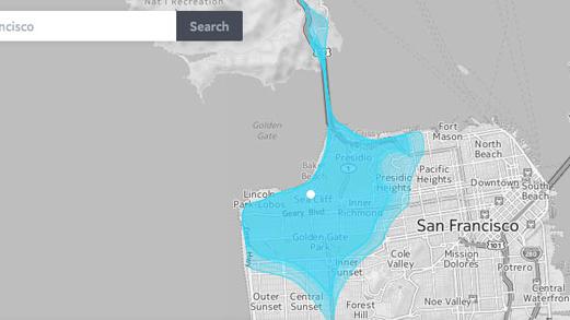
This map shows you how far you can go in 10 minutes
Commuting is often, no, regularly, hell. And now there's a map to prove it. Enter a city into the Isoscope map, and it will show how far a two, four, six, eight and ten-minute drive will take you, specific to the day of the week -- and to a prescribed hour of awful, awful rush-hour traffic. You can click multiple areas and adjust the hour, increasing or decreasing where you're able to go. If you've only get a 30-minute lunch break, you can try to make that work. "We wanted our project to shed light on situations when urban mobility is compromised, when the pulse of the city falters, such as during traffic jams," developer Sebastian Kaim told Fast Company. There's also a pedestrian option for non-drivers, and after testing a few cities and times, we're thinking next week could well be a work-at-home kind of a week.
Mat Smith05.24.2014
Traffic Cam Viewer for iOS is free and easy to use
Traffic Cam apps are pretty popular. Traffic Cam Viewer (free for a limited time) is basic but does the job, and it works for traffic cameras just about anywhere in the world. Most of the traffic apps are specific to a region or particular road, while Traffic Cam Viewer can be set to view cameras almost anywhere. To get things started, you take a trip to the setup menu and scroll to an area you are interested in. It could be a state in the US or another country altogether. Another scroll wheel then appears, from which you can select specific traffic camera locations. In preferences, you can adjust the display for the number of viewable columns. Traffic Cam Viewer can go beyond the basics of just looking at traffic camera feeds, which sets it a bit apart as an app of this genre. If you click on a specific camera the image zooms in, and that feed can then be shared with others. The traffic appears to update in real time, with a new frame appearing every few seconds. Frame rate is dependent on what the particular camera is sending. In my area some of the cameras were not functioning, and Traffic Cam Viewer warned me when I selected them. The app is ad-supported, and I didn't find the ads intrusive, especially since the app is free for now. I doubt if I'd want to see the ads if I was paying for the app. Traffic Cam Viewer is a nice app with a worldwide reach. Other apps with similar functionality are the free Traffic Cameras +Toll and Travel Information, and USA Road Conditions and Traffic Cameras. Traffic Cam Viewer requires iOS 4.3 or greater. It's a universal app and it's optimized for the iPhone 5.
Mel Martin03.18.2014
ETA is a helpful app for estimating your arrival time
ETA (U$1.99 on sale for a brief time) is a helpful app that estimates the driving time from your current location to your destination, taking local traffic tie-ups into consideration. To get started, you type in the name or address of a destination, clicking the '+' button to add it to your list. Once that's done, your location appears on a map. If you type a fairly common name, like Olive Garden, you may see more than one location. Check the one that has the address you want. When you tap on your saved location, you'll get an option to get directions and the app launches Apple Maps, Google Maps (If you have it on your iPhone) or Waze (if you have that app). One of the nice things about ETA is that you can get driving times to multiple locations with a glance. As traffic conditions change, those driving estimates change as well. Of course you can get estimated driving time in Apple Maps, Google Maps or other navigation apps, but it takes several steps. Here, all your favorite destinations with driving times are listed as soon as you launch the app. There are a couple of things that would make this excellent app even better. If you want a home address or anyone else's that is not a business, you have to type it in manually. It would be oh-so-much-better if the app had access to your contacts. Also, your list is in chronological order by when you entered the locations. I would like to be able to edit the order of the list, perhaps putting my home at the top. Other than that, ETA is an extremely useful app that I will use all the time. It's the kind of thing Apple should build into Maps. Yes there are bookmarks, but this is far better than fumbling around with buttons in maps. ETA requires iOS 7 or later. It's not universal, but should work on any Apple hardware that supports iOS 7. ETA is optimized for the iPhone 5. I like it.
Mel Martin02.28.2014
This concept car uses its own reconnaissance drone to spot traffic jams
The idea of receiving traffic updates on your sat nav may suddenly seem tawdry next to this more futuristic alternative dreamed up by Renault: If you're driving along in its "KWID" concept car and you're worried about jams up ahead, you simply launch a quadrocopter drone from the car's roof, send it skyward using a control app on your tablet and then survey the road through its camera. Would it be distracting, trying to perceive two views at once without the multitasking skills of an Apache pilot? Whose insurer would pay out if your drone pranged someone else's? Fortunately, these questions need not concern us, as Renault readily admits that the KWID will probably never see the light of an assembly plant. And in any case, if the technology does come about one day, the parallel advent of semi-autonomous cars and mind-controlled drones would surely make it practical.
Sharif Sakr02.07.2014
Mitsubishi cars get Nokia's Here Traffic road updates in near real time
If you're the sort of driver who needs up-to-the-moment road conditions, you may want to consider a Mitsubishi for your next ride. The automaker's touchscreen-equipped 2014 Lancer and Outlander models in North America can now use Nokia's Here Traffic services, including (almost) real-time congestion alerts, fuel prices and weather. The cars don't need direct internet access; all data goes through HD Radio, which has enough bandwidth to provide updates every 30 seconds. While Here Traffic is only one piece of a full navigation system, it's hard to object to getting more connected car services at relatively little cost.
Jon Fingas10.07.2013
Nokia Here research brings map data to life (video)
Nokia Here collection vehicles aren't the only way the Finnish giant is gathering data about our highways and city streets. The company's researchers are also using anonymous smartphone, PND and even CAN bus data to further our understanding of traffic flow and driver behavior in different conditions. Beyond improving maps and navigation, the goal is to make our roads better and cars smarter. We recently spoke with Nokia's Jane Macfarlane, Head of Research for Here, who shared how her team is bringing map data to life with the collaboration of opt-in smartphone users and fleet vehicle operators. Take a look at our gallery below and watch the video after the break.
Myriam Joire08.22.2013
Google visits reportedly represent nearly 25 percent of North American web traffic
Google's pretty popular here in North America, but one analytics firm is reporting some figures that might sound a bit too good to be true. DeepField, a company that focuses on analyzing web performance, is today claiming that Google broke a web record within the last month -- visits to the site now represent 25 percent of all North American web traffic, with 60 percent of all internet-connected devices accessing the service each day. Netflix, for its part, represents the leader in bandwidth (despite YouTube falling under the Google umbrella), but far more users access the search site within a 24-hour period, as you'd probably expect. Without a statement from Mountain View, it's important to note that these figures are unconfirmed. Considering Google's reach, however, the claims might not be far off.
Zach Honig07.22.2013
Google Maps 2.0 for iOS starts rolling out with iPad support, indoor maps (update: offline maps too)
The revamped Google Maps design reached Android last week; now, it's iOS' turn. Google Maps 2.0 is gradually rolling out worldwide for Apple's platform, and it's bringing the Android version's discovery and exploration components as well as some new-to-iOS features. Long-anticipated iPad support is the highlight, although there's also indoor navigation, live traffic updates and incident reports. Maps 2.0 hasn't hit the US just yet, although it should be available shortly. Update: It looks like it's hit the US App Store as of midnight ET or so, check the link below to grab the update yourself. If you're looking for offline maps, those are available with an Easter Egg like the one first featured in the Android version. Just zoom to the area you'd like to cache, then type "Ok maps" in the search box. [Thanks @carloslarez]
Jon Fingas07.16.2013
Google has purchased Waze
Google announced in a blog post today that it is acquiring social traffic company Waze. This announcement is not surprising as Google was rumored to be close to inking a deal with the Israeli startup. Google was one of many suitors reportedly courting Waze -- earlier rumors hinted at a potential deal with Apple, but that rumor was shot down. More recently, Facebook was supposedly looking to add the company to its coffers. According to Google, Waze will remain in Israel and operate as an independent company for the time being. Google will eventually bring some of Waze's community-sourced traffic information to Google Maps and will add Google's powerful search engine capabilities to Waze. Presumably, the Waze iOS app will keep chugging along, but there is no word what will happen to Waze's contribution to Apple Maps.
Kelly Hodgkins06.11.2013
Google reportedly closing in on $1.3 billion deal for Waze traffic app (updated)
Last month news leaked that Facebook might acquire crowdsourced navigation / traffic / mapping app Waze, but now two papers in Israel say Google is about to close the deal. Globes and Calcalist both peg the potential sale price at $1.3 billion US, with the company's development team remaining in Israel after the sale and not moving to the US. Where they will work from is cited by Globes as one reason why negotiations may not have worked out with Facebook, along with the price tag. For those unfamiliar with Waze, the app generates mapping data in real-time based on its nearly 50 million users and reports of accidents or traffic jams. Update: Not to be left out, the Wall Street Journal also claims that Google is near buying Waze. The newspaper hears that the Waze app could soldier on while Google beefs up its own mapping app with data from its reported target. Likewise, Google Maps information could slip into Waze.
Richard Lawler06.09.2013
How to turn off Google Now and keep your battery charged
Google has recently added its Google Now service into its search app for iOS, but there's one big drawback to getting constant weather, traffic, and other local information on your phone: Location Services runs constantly. You can tell by the little arrow icon up in the corner of your home screen. Usually, that service only flips on when your phone needs to know where it is, but Google can be greedy with that information, keeping your Location Services on all the time, and thus draining your iPhone's battery much faster than it would otherwise. So what's the solution? Inside Apple's Settings app, you can manually turn off Location Services for each app that uses it, so if you want to keep Google Now from draining your battery you could turn off Location Services altogether. Another approach, suggested by Mac OS X Hints, is to turn off the Now feature within the Google Search app, and only re-enable it when needed. Not the best solution, but it works for sure. Our commenters point out a somewhat less draconic approach to toning down Google Now's location access: in the Privacy settings within the Google Search app, you can disable Location Reporting. With that option turned off, Google Now won't keep track of your location in the background -- it will only check when the app is actually open and in use. This may decrease the utility of the traffic cards, for instance, but it should help battery life. I had the same issue, actually, with Google's Field Trip app. I thought the app worked great, but it definitely drained my battery, and the constant notifications got to be a bit much. The solution I found there was simply to sign out of the app when I didn't want to hear from it, and that's worked all right; it does reduce the spontaneous discovery of nearby attractions that Field Trip tries to deliver, but that's a trade I am willing to make. Ideally, both of these apps would have big on/off switches included, so users could make sure the apps were only active when they were needed. We should note that Google's help document for Google Now suggests that the location reporting feature ought to have minimal impact on battery life, but that isn't necessarily matching up with the real-world experience of users with this first version on iOS. Hopefully, Google will hear some of these complaints, and we'll see the apps work a little less greedily in the future. Post updated to clarify MacOSXHints recommendation. Update: Google has gotten in touch with TUAW to say that these claims of battery draining simply aren't true. The company says they tested the apps thoroughly, and while other apps using Location Services may drain your battery, Google tells us that these apps won't. Whether or not you want to leave these services on, then, is up to you. Here's Google's full statement: Reports that Google Now drains battery life are incorrect. We understand people's concern about seeing the Location Services icon stay on when they use Google Now. Many apps that keep the icon on actually do drain the phone's battery because they require very accurate location. (For example a navigation app has to run your GPS all the time to keep you from missing your turn.) Google Now is built very differently: it uses cell towers and wifi hot spots for much lower battery impact. We extensively tested Google Now on iOS for months and didn't see reports of significant battery impact -- we would encourage you to try it in the Google Search app for a few days and we don't expect you to see significant impact on your battery. If you are seeing a problem, please do tell us (just tap feedback in the app settings). We take user feedback very seriously.
Mike Schramm05.01.2013
Telenav Scout for Phones to go 3D, get crowd-sourced traffic reporting in 2013
There are plenty of choices to meet your mobile mapping needs, from feature-rich offerings from big names like Google, Apple and Nokia to crowd-sourced services like Waze. Telenav's Scout app falls somewhere in between, and today the company announced that it'll get both 3D buildings and landmarks and crowd-sourced traffic reporting (backed by TomTom's database) later this year. Graphically, Scout in 3D looks similar to Google Maps and will initially be available for major metro areas in the US. As for traffic reporting, Telenav will be asking its 34 million subscribers to report accidents and traffic jams, and will update its database in real-time. That means that as road conditions change, Scout'll suggest faster alternate route options to get you from point A to point B hassle-free. No word exactly when these new capabilities will make it to users, but when they do arrive later this year, both premium and free users will get 'em. In the meantime, check out the video of the new 3D maps in action after the break.
Michael Gorman04.15.2013
Waze maps respond to road closings
Waze (free) is a fun mashup of GPS navigation, social networking and gaming apps that uses the information gathered from the location of users' phones to offer directions and live traffic reports. As reported by Joshua Brustein of the New York Times Bits blog, Waze is now able to change maps in real time to reflect temporary road closures. Waze gathers traffic speed info from drivers' phones, and currently has about 40 million users contributing to the stream of data. Unfortunately, if a road is closed suddenly because of weather or a bad crash, the Waze system has no way of knowing about the closure to change maps accordingly. The folks at Waze decided to call upon drivers for help. Drivers currently get "points" for allowing the app to track their speed or by pointing out construction and speed traps. If drivers are stopped due to a closure, they can now report it for extra points. As Waze's algorithms begin to receive more and more driver verification of a road closure, the system begins routing other drivers around the blockage. Waze is also being used in some other new ways in the aftermath of Hurricane Sandy. The company worked with the Federal Emergency Management Agency to pass along information about gas stations that were out of fuel, allowing the agency to deploy its refueling trucks where they were needed most. Waze is also now supplying information to the Georgia Department of Transportation to help create reports for electronic traffic signs on major highways and plans to expand that program more in the future.
Steve Sande02.27.2013
Shazam mention, blackout at Super Bowl drives mobile engagement
Velti is a firm that runs advertising on mobile platforms like iOS and Android, and they were paying close attention during last Sunday's Super Bowl game to how and when mobile users were on their phones. The company has released a few tidbits about mobile usage during the big showdown, and they reveal quite a bit about when we picked up our phones during the game. Velti says that while the Ravens may have won the game, Jack in the Box was the biggest win on the mobile side: The company's "Hot Mess" commercial (which featured a big plug for Shazam, who we spoke with about exactly this situation at CES) was the most active mobile engagement driver during the entire show. Viewers saw the bug, and immediately picked up their phones, presumably to either check out Shazam or use the app on the commercial spot (though it was only 30 seconds, so they had to hurry). Mobile engagement also spiked, says Velti, during the brief blackout delay that the stadium experienced. In that same vein, the halftime show was actually the point at which viewers were least engaged in their phones, suggesting that Beyonce's song and dance distracted them back away from the smaller screens. And the game itself distracted viewers from their phones as well -- the relatively boring first half had more mobile usage, while the second half of the game, when the 49ers staged a comeback against the Ravens, saw mobile usage drop. There's a lot of very interesting insight in there about exactly how mobile users make use of their second screen devices. The Jack in the Box / Shazam spike is no mistake, and we can likely expect to see even more moves like that in the future. Our mobile phones are nearly always with us these days, and other screens, including television, have lots of opportunities to use Apple's platforms for even more engagement.
Mike Schramm02.05.2013
Just Landed is a neat twist on travel apps
There are lots of travel apps, but Just Landed from Little Details is really different and handy. This app is not for the traveler, but for the person picking someone up at the airport. Just Landed (US $0.99 for the iPhone) tracks a flight you are going to meet and sends an alert when it is time to go to the airport. It helpfully tells you about any flight delays and any automobile traffic snafus before you leave. The app also connects to Apple Maps and shows you the best routes to the airport. It's a terrific idea, and something unique for a travel app. The app also lets you text the person you are picking up when they arrive, and if your starting location changes, the app recalculates your arrival time based on those changes. When you get an alert from Just Landed, it is a rather obnoxious sound of a jet engine. I wish that could be changed to something less jarring, but it does get your attention. The alerts can be turned off, if you prefer. You can tell from the clean and simple GUI design that a lot of thought went into Just Landed. This is the kind of app I will get a lot of use out of, and it is such an obvious idea I am surprised there aren't lots of competitors. If you spend a lot of time picking up family and friends at your local airport, then Just Landed is the app for you. It supports US and Canadian airports, with more locations to come. The app requires iOS 5.0 or later, and is optimized for the iPhone 5. %Gallery-171661%
Mel Martin11.23.2012
Sandvine: Netflix up to 29 percent of North American internet traffic, YouTube is fast on the rise
When we last checked in on one of Sandvine's traffic studies, Netflix had just edged past BitTorrent as the largest source of internet traffic in North America while YouTube was still a small-timer. A year has made quite the difference. Netflix is up to 28.8 percent in a new study, while YouTube has moved up to second place with 13.1 percent and demands even more than ordinary web requests. Rivals like Hulu don't register in the top 10, and YouTube is by far the ruler of mobile with nearly 31 percent of smartphone traffic headed its way. Overall usage is moving up rapidly, no matter what kind of network the continent uses -- the typical North American chews up 659MB per month when mobile and a hefty 51GB through a landline. There's little reason to dispute worries of the impact on bandwidth-strained internet providers, although we suspect most would disagree with Sandvine on what's to be done. The company naturally sees the study as a chance for business with carriers wanting to curb usage or charge extra through its tools; a generation that grew up with internet access, however, would likely see it as a better excuse to roll out more capacity for all those streaming videos.
Jon Fingas11.08.2012
Google Maps unveils new features in India, New Zealand and 150 universities worldwide
Google is bringing voice-guided turn-by-turn navigation to Android smartphone users in India. While the functionality's been available since January if you've rooted your device, the official version lands today with a localized "Indian English" voice option. At the same time, it's adding live traffic information for major roads in big cities like Mumbai, New Delhi and Hyderabad -- with both arriving today on handsets running Gingerbread and up. At the same time, it's giving Google Map Maker and Biking Directions to users in New Zealand -- and college students at over 150 universities worldwide will now be able to find themselves thanks to Street View maps on campus. Of course, that does mean you can no longer use Google as an excuse as to why you missed Phys. Ed. 202 next semester. [Thanks, Devanshu]
Daniel Cooper09.06.2012
iOS and Android make for fastest tech adoption ever
Mobile marketing and analytics firm Flurry has another great research post up, this time about the speed of adoption for both iOS and Android. This one goes a little far into comparing apples and oranges, so to speak, but it's still interesting. Flurry notes that both iOS and Android app usages has blown up in the last few years, so much so that it's seeing traffic increases of over a few hundred percent from the past year in places like China, Brazil, and Chile. Flurry now estimates that there are over 640 million iOS and Android devices running apps worldwide, and given the huge growth of that number, as well as the big numbers behind app and data usage on those devices, these smartphones are being adopted by users "10X faster than that of the 80s PC revolution, 2X faster than that of 90s Internet Boom and 3X faster than that of recent social network adoption." Unfortunately, Flurry doesn't share the exact numbers behind those stats (not to mention that it's hard to compare numbers like that anyway, given how tough it is to calculate in numbers what a "revolution" in the tech sense actually means). But the point is clear: The current smartphone growth is a huge movement in the tech industry, and is taking place on a much faster and larger scale than ever before.
Mike Schramm08.27.2012
Scientists investigating AI-based traffic control, so we can only blame the jams on ourselves
Ever found yourself stuck at the lights convinced that whatever is controlling these things is just trying to test your patience, and that you could do a better job? Well, turns out you might -- at least partly -- be right. Researchers at the University of Southampton have just revealed that they are investigating the use of artificial intelligence-based traffic lights, with the hope that it could be used in next-generation road signals. The research uses video games and simulations to assess different traffic control systems, and apparently us humans do a pretty good job. The team at Southampton hope that they will be to emulate this human-like approach with new "machine learning" software. With cars already being tested out with WiFi, mobile connectivity and GPS on board for accident prevention, a system such as this could certainly have a lot of data to tap into. There's no indication as to when we might see a real world trial, but at least we're reminded, for once, that as a race we're not quite able to be replaced by robotic overlords entirely.
James Trew08.26.2012