google street view
Latest
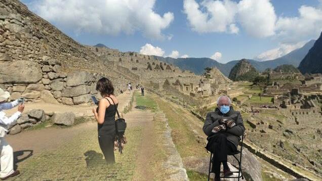
Put Bernie Sanders almost anywhere with this Google Street View app
It seems the senator is a well-traveled man.

Google takes you inside Anne Frank's childhood home with Street View
June 12th is the 90th birthday of Anne Frank, and to mark the occasion, Google is letting you step inside the childhood home of the diarist. A virtual exhibit in the Arts & Culture app and website takes you inside Merwedeplein 37-2 in Amsterdam. You can also explore the space through an indoor version of Street View. All the 1930s-styled rooms of the home, which is now a temporary home and work space for refugee writers that's closed to the public, are viewable.
Google shares its Street View air-quality data with scientists
Google is releasing air quality data it collected from California's Bay Area and Central Valley with its Street View cars, part of a larger effort by the company to track pollution around the world. The data was captured over the last three years and includes measurements that were taken after wildfires in the Wine Country region and from the agricultural regions of Central Valley. While the full dataset isn't available to the public, scientists can request access through a form.

ICYMI: Street View pollution hunt, Easier Amazon and more
#fivemin-widget-blogsmith-image-768351{display:none;} .cke_show_borders #fivemin-widget-blogsmith-image-768351, #postcontentcontainer #fivemin-widget-blogsmith-image-768351{width:570px;display:block;} try{document.getElementById("fivemin-widget-blogsmith-image-768351").style.display="none";}catch(e){}Today on In Case You Missed It: Google Street View cars are rolling through U.S. cities to measure pollution, measuring harmful compounds like methane and carbon monoxide. Amazon's new Dash buttons are now available, which let consumers instant-order basic household items with a push of a literal button. And NASA is crashing planes to help improve the reliability of Emergency Location Transmitters, so that the signal actually turns on when something goes terribly wrong.
ICYMI: Street view climbing, a "real" hoverboard and more
#fivemin-widget-blogsmith-image-880458{display:none;} .cke_show_borders #fivemin-widget-blogsmith-image-880458, #postcontentcontainer #fivemin-widget-blogsmith-image-880458{width:570px;display:block;} try{document.getElementById("fivemin-widget-blogsmith-image-880458").style.display="none";}catch(e){}Today on In Case You Missed It: Tesla's teased a prototype car charging station powered by strangers' footsteps; Lexus released a video of a hoverboard that's "rideable now," (psst ... it still needs magnets and isn't as cool as this); and Google used mountain climbing's most famous men and women to take street view to Yosemite's El Capitan in this trippy video.

Tour Destiny's off-world locales via Google Street View
Want to walk through the worlds of Destiny without waiting until next week's launch (and without the usual dudebro audio commentary)? You should tour DestinyPlanetView.com, which allows you to visit the sci-fi shooter's version of Venus, the Moon, and Mars using the exploration tech behind Google's Street View tool. There's a brief preview trailer of the site in action just past the cut.

Explore the world of 'Destiny' through Google Street View
Whether it's touring an insanely large cruise ship or the Polar Bear capital of the world, Google's Street View has you covered. But the search giant doesn't want to limit that virtual experience to tangible, real-life things, which is why it's teamed up with Bungie to let you experience the magical nature of Destiny by way of Street View. Once inside, explorers can choose to wander around and learn more about places that are key elements to the storyline of Bungie's new franchise. Destiny Planet View, as the map is officially known, offers detailed, 360-degree views of locations inside Mars, Venus and the moon. It gives the breakdown on various hotspots, more information on characters from a particular territory and allows users to access Destiny tips along the way. Bungie points out that this is the first time Google's mapped a video game world, and it's a good one -- sure, it's pretty to look at, but the real goal is to get you even more hyped up ahead of Destiny's launch, next week on September 9th.

Google's Trekker project brings beautiful Hawaii imagery to Street View
After launching Street View Trekker last year, Google is now starting to show us what we can expect from its loaner program. What you see above are some pictures from the Hawaii Tropical Botanical Garden, which were taken by Google's first Trekker partner, Hawaii Visitors and Convention Bureau, and added to Street View as part of the company's imagery project. The search giant says there's a lot more where that came from too, including beaches, historical sites, hiking trails and parks. And with the summer right around the corner, this is a perfect opportunity to virtually explore The Islands of Aloha before booking your next vacation.

Google Street View adds 1,001 new destinations, lets you explore from afar
The folks from Mountain View are constantly adding more and more features to Street View -- and, well, today's no exception. Via its Maps blog, Google announced that it's giving Street View a hefty boost by adding over 1,000 fresh destinations to the mix, noting that the idea is to make it "more comprehensive and useful for you." There's new imagery from places in Asia, Europe, Latin America, Canada and, of course, the US, allowing users to check out sites like the Seville Cathedral (Spain), Bosque de Chapultepec (Mexico), The Mark Twain House (USA) and many, many others. Google's highlighted some of these new destinations on its website, so pay the source link below a visit if you're interested in a quick, virtual tour around the world.

Google Trekker goes to the Grand Canyon, takes Street View souvenirs back home
You might remember Google's unveiling this spring of the Street View Trekker, a seeming cross between a backpack and Van de Graaff generator that lets the mapping team produce 360-degree imagery where even trikes dare not tread. The portable camera ball is just going on its first trip, and Google has chosen the most natural destination for a novice tourist -- the Grand Canyon, of course. Staffers with Trekkers are currently walking trails along the South Rim of the canyon to provide both eye-level points of reference for wayward hikers as well as some breathtaking, controllable panoramas for those who can't (or won't) make it to Arizona. Once the photos make it to Street View sometime in the undefined near future, it'll be that much easier to turn down Aunt Matilda's 3-hour vacation slideshow.

Visualized: Google Street View car fleet gets ready to conquer (and map) the world
Ever wonder how Google can make such grandiose claims for the sheer amount of Street View imagery it collects? Here's how. Google's Masrur Odinaev has posted a snapshot of a central mapping car parking lot that shows dozens of the camera-equipped Subaru Imprezas amassed ahead of future runs. While it already represents more Street View cars in one place than anyone outside of Google would normally ever see, what's most impressive is remembering that this addresses just a portion of the entire vehicle mix -- aside from the local cars you don't see in the photo, there are extra units worldwide providing street-level coverage alongside tricycles and underwater expeditions. Odinaev's look reminds us just how much effort is needed to make Street View a common feature -- and that there are are legions of Google staffers whose low-profile work goes a long way towards making our navigation easier.

Google's 'biggest ever' Street View update doubles special collections, refreshes 250,000 miles of roads
Google's eponymous mapping system has received plenty of good press recently, but the company knows it can't take some time out to enjoy its position. As such, Mountain View's pushing out what it calls the biggest update to Street View it has ever undertaken, refreshing 250,000 miles of road imagery and doubling the amount of special collections. Some of the new attractions you can visit from the comfort of your home include Catherine Palace in Russia, Stanley Park in Vancouver and Singapore's Fort Canning Park. We're thinking we might have to use the system the next time we fancy a cultural visit -- after all, we'd save a pile on airfares.

Daily Update for October 4, 2012
It's the TUAW Daily Update, your source for Apple news in a convenient audio format. You'll get all the top Apple stories of the day in three to five minutes for a quick review of what's happening in the Apple world. You can listen to today's Apple stories by clicking the inline player (requires Flash) or the non-Flash link below. To subscribe to the podcast for daily listening through iTunes, click here. No Flash? Click here to listen. Subscribe via RSS

Google Street View is back on the iPhone, but it's not pretty
Last night, Google made good on its promise to make Street View available on iOS devices, but it's not pretty. Google may or may not be working on its own iOS maps app, as Chairman Eric Schmidt says Apple device users shouldn't expect a Google Maps app anytime soon. In the meantime, Google's engineers did the next best thing -- they added Street View to the Web version of Google Maps. To view Street View, just go to maps.google.com in mobile Safari or Google Chrome for iOS. You can't just tap on any location to view Street View. Instead, you may have to tap on a business or transit stop, or start at a known point and then "move" in Street View to the location you wish to view. Unfortunately, there are some real issues with the temporary workaround. A number of users worldwide have reported gaps in the data where there was full coverage before, and Apple 2.0's Philip Elmer-DeWitt complained of frequent crashes. It's not the perfect solution we all wanted, but at least Street View is back.

Street View comes to Google Maps web app on iOS, just like they said it would
While the hubbub surrounding Apple Maps on iOS 6 has been somewhat sedated, some people who made the move to Google Maps' web app had been further encouraged by word that it'd be getting Street View imagery soon. And what do you know, barely seven days into the estimated "in two weeks" and here it is. Search for a location (no long press yet), and you'll spy the familiar icon bottom right. This appears in both Chrome and Safari. While perhaps still not quite as slick as the good old app of yore, a definite panacea for all those iOS toutin' virtual tourists.

Google Street View gets its first underwater panoramic images, ready for desk-based scuba expeditions (video)
After working on its sea legs for some time, Google Street View is ready to take users on virtual scuba expeditions through six living coral reefs with the first underwater panoramic images to hit the service. In partnership with The Catlin Seaview Survey, Mountain View created the on-rails snorkeling experiences using undersea pictures from Heron, Lady Elliot and Wilson Islands at the Great Barrier Reef, Molokini Crater and Hanauma Bay in Hawaii and the Apo Islands in the Philippines. Combined with views from Chichen Itza and Teotihuacan, the new underwater tours might make for a respectable, desk-based vacation. Interested in paddling through the briny depths? Head past the break for a short preview or hit the source links below to dive right in.

Google patent delivers close-up photos when your phone can't, Blade Runners would approve
It's been 30 years since we saw Deckard track down replicants by having a machine "enhance" pictures, and yet we're still stuck with distant-looking photos when we want more detail than our smartphone cameras can manage. While we'd argue that a few phones already live in that Blade Runner future, Google has just obtained a patent that could give the rest of us a helping hand. If the zoom isn't up to snuff, the proposed software could gauge a mobile device's position and orientation to offer a closer, already-taken photo from a server as a substitute, whether it's a Street View shot or a more traditional image. The geocoded system could even cue photos based on the time of day and year to provide that extra dash of authenticity. We already get a trace of the concept through photo overlays within Street View itself, although there's no indication as to whether or not Google will link our camera apps directly to a cloud of substitute photos -- suffice it to say that the industry has changed a lot since Google was using the iPhone 3G to illustrate its photography concepts.

Google Maps creation put under the microscope, reveals a human touch
They say you should never learn how the sausage gets made, but we're willing to make an exception for Google Maps. Talking to The Atlantic, Google has revealed just how much the human element figures into all that collected satellite imagery and road data. Many pieces of terrain information are tested and modified against what Google calls Ground Truth: actual driving, alternate sources and sign photos automatically extracted from Street View runs. Google isn't just making the occasional correction, either. Mapping a country can take hundreds of staff plugging away at the company's Atlas tool, even before we get a crack with Google Map Maker. The combination of man and machine helps explain why Google Maps is one of the most accurate sources of location information on Earth -- although the firm does have some catching up to do in space.

Garmin, Navigon GPS apps now consider mass transit, remember where we parked
Third-party navigation apps still tend to fall apart when the keys are out of the ignition -- try to cut back on car use and you're often kicked over to another app with its own set of rules. Both Garmin's StreetPilot Onboard app and its Navigon equivalent are getting a much more holistic experience through respective upgrades due this fall. Android and iOS users alike can soon buy an Urban Guidance pack that factors buses, subways and other forms of public transportation into their on-foot routes. The playing field is leveling off for drivers willing to stretch their legs, too: iPhone owners with Navigon's app get the same last-mile walking directions and parking finder as their Android counterparts. StreetPilot iPhone app users are left out of this last addition, but they'll see compensation in the form of an optional Panorama View 3D mode and the Google Street View they're about to lose from Maps in iOS 6. The updated titles will still cost $30 for Navigon-only regional packs, $50 for editions with US-wide maps and $60 for all of North America, although you'll need to spend $5 more ($3 during the first two weeks) for Urban Guidance and $10 for the Panorama View 3D pack.

Google Street View expands to cover swaths of Brazil and Mexican ruins, won't substitute for a vacation
For a country that dominates the Latin American landscape, Brazil hasn't had much of a presence in Google Street View outside of major cities like Rio de Janeiro or Sao Paulo. A fresh update to Street View coverage has just gone live that fleshes out the more far-flung corners of the map. It's now possible to see what it's like on the ground in much of the southern tip of the country as well as the northern coastline. Further north, Mexicans get their own treat: Google is now providing the panoramic views for ancient ruins such as Chichen Itza and Teotihuacan, just in case you'd rather not try to blend in with all the other tourists. The widened reach is undoubtedly no match for booking a flight and visiting in person, but it will save you the trouble of brushing up on your Portugese or ancient Mayan.


