mapping
Latest
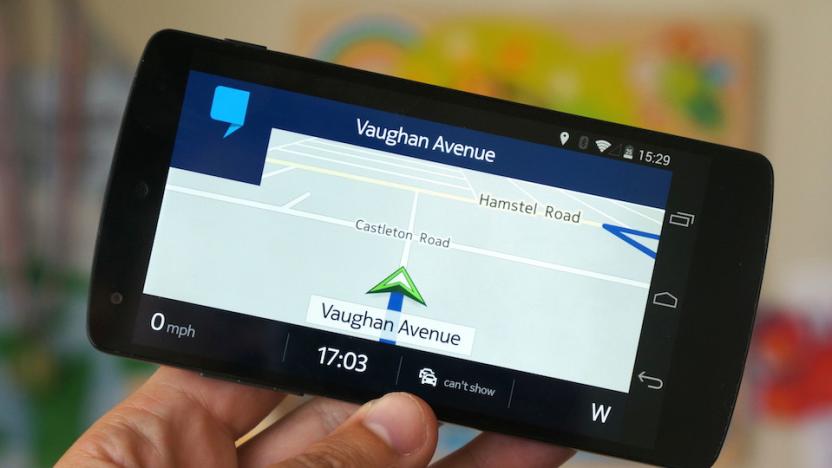
Hands-on with Nokia's Here Maps for Android
When Microsoft finally completed its €3.79 billion acquisition of Nokia earlier this year, the company took control of its smartphone business, but left behind a number of Nokia's other powerful and profitable properties. One such property was the company's mapping division, now called Here, which has become the de facto maps app for Windows Phone users the world over. Nokia tried to replicate the experience on iOS, but after poor reviews and the admission that things "went horribly wrong," the company pulled its iPhone app and went back to the drawing board. As for Android, it looked like Nokia would never deliver a real Google Maps alternative. Luckily, that's all about to change. Thanks to some marketing muscle from Korea, Nokia will soon give Samsung Galaxy smartphone owners advanced access to its maps app. While Nokia readies Here Maps for Samsung's Galaxy Apps store, which is expected to drop in the coming weeks, the company gave us an early preview of its new app, and it's good.

Watch this: Human transforms its app data into striking activity maps
The folks behind Human know a thing or two about aesthetics, having crafted an activity-tracking app for iOS that's quite lovely. The mobile software keeps tabs on walking, running, biking and vehicular motion with goal of racking up at least 30 minutes of physical activity per day. Now, the outfit has taken user data from 30 of the largest cities in the world and constructed visualizations for each locale. Maps for all three of the aforementioned endeavors are included, broken down by activity for further analysis. Don't take our word for it though, watch the cartographic motion take place for yourself after the break.

Cash-rich Nokia invests $100 million to boost connected car tech
Despite a huge influx of Microsoft dollars, Nokia still has to make a living in its new handset-free order and it looks set to expand one of its most profitable apps: Here. It just launched a $100 million connected car endeavor through the Nokia Growth Partners (NGP) fund to invest in technological innovations around travel and mapping. The purpose is to "grow the ecosystem around Here's mapping and location products" for cars by investing in companies developing such tech. Now that it's no longer wedded to Windows Phone, it's also pushing for native Android and iOS apps, judging by some LinkedIn ads sniffed out by NPU. One seeks iOS and Android developers to produce "industry leading mobile SDKs," while the other is looking for Here Android developers for crowd mapping. We imagine Microsoft will remain a steady customer for Here and other Nokia apps, which are some of the best on WP8. And giving Android and iOS users a solid mapping alternative can't hurt either.

Open data gives rise to a virtual Denmark in Minecraft
Since the US government opened its troves of public data we've seen some pretty neat projects like climate-change prediction tools and deforestation-monitoring systems. Denmark, on the other hand, has taken a different approach: the Danish Geodata Agency used internally developed topographic maps and elevation models to build a 1:1 recreation of the happiest country within Minecraft's blocky confines. Unlike the virtual Great Britain we've seen before, this pixelated Denmark is more than just natural features like hills and forests. As Ars Technica has spotted, it includes accurate replicas of highways, homes, landmarks and businesses too. The project was intended to showcase the country's open-data initiative to its students and educators, but anyone can take a gander until the Danish government's game servers shut down in late October. Server rules, however, have disabled enemies and TNT -- no Creeps allowed, naturally.
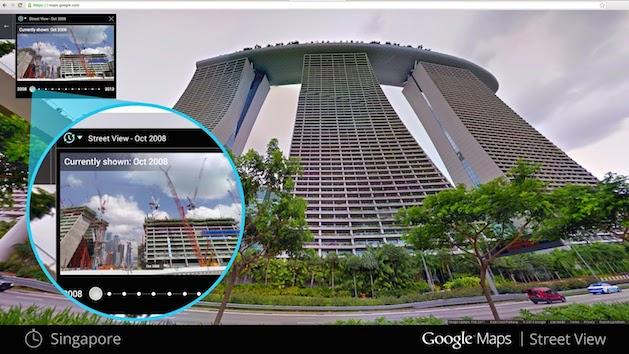
Google Street View now serves as your own personal time machine
In the seven years since Google launched Maps, it's collected a ton of imaging and location data, which we've only been able to see in its most recent form. That's about to change, however, after the company announced it's opening all of that information up, allowing you to go back and see how much each of its locations have adapted during that period. Starting today, Google says it will begin rolling out the new feature across its desktop Maps service, adding a new clock icon to Street View images. Once clicked, you can move a slider and select the different thumbnails of a location in a particular space in time. You'll see skyscrapers go up, houses come down, and maybe even witness the rebuilding efforts of a community affected by a natural disaster. There's no word on whether it'll make its way beyond the desktop, so for now you'll likely only be able to procrastinate from the comfort of your home computer or office.

Japanese robot gets better at not running into people
Hitachi is taking Asimov's I Robot law about not harming humans more seriously with new tweaks to its wheeled Emiew 2 bot. The 30-pound humanoid now packs a sensor that'll measure walking speeds (in an office, for instance) and generate mapping data to predict where someone might pop up unexpectedly. It'll then avoid those areas or slow down so as not to roll into your kneecaps. Given Emiew's 31-inch frame and 4 mph speed, we weren't too worried anyway -- there are other, decidedly more terrifying robots to avoid.

Ex-Ubisoft devs unveil ReRoll, an ambitious stab at turning reality into a game
For years, games have repeatedly tried to outdo one another in the quest for the most expansive, interactive open-world experience possible, but what could offer more true freedom than our own planet? That's the basic idea behind ReRoll. In development at Pixyul, a new studio created by two former Ubisoft developers, ReRoll uses civilian aerial drones to capture images from all over the globe which are then stitched together to create the in-game world. Further, ReRoll employs a "Reality Sync System," that takes real-time environmental data from our reality and feeds it into the game. If it's snowing in Chicago, ReRoll's virtual rendition of the Windy City will likewise be blanketed in fluffy white flakes, Pixyul claims. Little is known of ReRoll's gameplay, though its developers describe the game as a survival action-RPG. "To subsist, you need to eat, rest, exercise, learn, fight but most of all find all the different ways to survive," reads the game's official description. While no release date has been established for ReRoll, Pixyul has set up a crowdfunding effort on the game's website. As with most fundraising attempts, those who contribute money to the development of ReRoll will earn exclusive swag in exchange for their blind faith in the project - in this case, weaponry and vehicles to be used in the game. [Image: Pixyul]

Google's Street View takes you up Mount Fuji, crampon free
In contrast to its happy visits to the Eiffel Tower and Burj Khalifa, Street View's exploration of Dead Island may have given you the wrong impression of Japan. Luckily, one of the country's most picturesque symbols, Mount Fuji, was recently scaled by what must be some of Mountain View's most athletic trekkers. The fruits of the 12,400-foot climb and incessant photo stops are 14,000 separate panoramas, including many sunrise shots only available to diligent night climbers. They're now live on Maps, so hit the source or panorama after the break for a far less taxing peek.

Dead island that inspired Skyfall comes to Google Street View (video)
It goes by the name of Hashima, or Gunkanjima ("Battleship Island"), or even "The Dead Island", since it inspired the water-locked cyberterrorist HQ in Skyfall. Explore it for yourself, courtesy of the new Google Street View (and official "making of" video) embedded after the break, and you'll see that it's a very real place off the coast of Japan's Nagasaki Peninsula, and it's even lonelier than its fictional counterpart in the Bond film (which wasn't actually filmed there). There are no tourist offices or giant Oedipus Complexes, as far as we can see, just long stretches of overgrown roads and collapsing apartment blocks that once housed 5,000 people, before they abandoned the island in 1974 following the demise of its coal industry. It took a Google employee two hours to map the place and preserve its crumbling visage for posterity using a special backpack, but don't be surprised if you want to leave it after just a few minutes.

LIDAR reveals ancient city remnants beneath Cambodian jungle
LIDAR scanning has recently become cost-effective enough for archaeologists to use on large historical sites, and they're taking full advantage. A helicopter jaunt last year has revealed a massive urban site below the jungles near Angkor Wat in Cambodia that likely housed thousands of people. New canals, temples and other man-made structures were discovered during a two-day scan, which emitted up to 200,000 laser pulses per second and would have taken years if done by traditional excavation methods. The technique can scope out features as small as a footprint, and is also being used in cities around the Egyptian pyramids and other archaeologically interesting regions -- marking another way that Indy-style archeologists are becoming obsolete.

TomTom pairs with TrafficLand to provide live roadside footage to devs
TomTom is looking to beef up its location based services portal by joining forces with TrafficLand to bring real time traffic video to its developers. TomTom's LBS will now incorporate TrafficLand's network of over 13,000 roadside webcams, enabling developers to integrate live footage into their location-enabled apps via the Traffic Camera API. TrafficLand's real-time video will join the other cloud-based location services TomTom provides to devs, like map content, routing and geocoding. For right now, TrafficLand covers only the US, UK and Canada, and it's not clear if the company plans to expand beyond those three countries anytime soon. For more information, you can take a gander at TomTom's full press release, embedded after the break.

Sign-up page for revamped Google Maps shows off plenty of new features
Just hours before its I/O event, Google has apparently had a little accident: the sign-up page for "the new Google Maps" briefly went live, revealing a slew of extra details about what's coming in the rumored refresh before quickly being pulled. Droid-Life managed to grab some screenshots, including the one above, which gets to the heart of what Google is trying to achieve. The central idea is that Google will create maps tailored to the kind of information you're looking for, using a "smarter search box" to highlight just the "things that matter most," whether those be flights, ground transport or the new Earth View that integrates directly with Google Earth without the need for a plug-in. According to the leaked sign-up screens, the bringing together of all Google's data will result in layers of information that reach "from outer space down to the streets" -- but there's still no evidence about how (or whether) this might work on mobile. Stay tuned to our Google I/O opening keynote liveblog for more.

Eyes-on: MIT Media Lab's Smarter Objects can map a user interface onto... anything (video)
While patrolling the halls of the CHI 2013 Human Factors in Computing conference in Paris, we spied a research project from MIT's Media Lab called "Smarter Objects" that turns Minority Report tech on its head. The researchers figured out a way to map software functionality onto tangible objects like a radio, light switch or door lock through an iPad interface and a simple processor / WiFi transceiver in the object. Researcher Valentin Huen explains that "graphical user interfaces are perfect for modifying systems," but operating them on a day-to-day basis is much easier using tangible objects. To that end, the team developed an iPad app that uses motion tracking technology to "map" a user interface onto different parts of an object. The example we saw was a simple radio with a a pair of dials and a speaker, and when the iPad's camera was pointed at it, a circular interface along with a menu system popped up that cannily tracked the radio. From there, Huen mapped various songs onto different positions of the knob, allowing him to control his playlist by moving it -- a simple, manual interface for selecting music. He was even able to activate a second speaker by drawing a line to it, then "cutting" the line to shut it off. We're not sure when, or if, this kind of tech will ever make it into your house, but the demo we saw (see the pair of videos after the break) seemed impressively ready to go.

Waze CEO Noam Bardin: the future of mobile is fighting for a user's time
Noam Bardin, CEO of Waze, just took the stage here at D:Dive Into Mobile, taking part in a wide-ranging discussion hosted by Liz Gannes. Aside from dodging questions about potential acquisitions, Bardin made no bones about how he saw the future of mobile playing out. Of course, this is a man who spends essentially no time focused on the desktop web -- given that Waze is mobile only, one shouldn't be surprised. According to Bardin, "the next five years will be about fighting for time with users," and he pointed to Facebook Home as the de facto example of that. Rather than crafting their own OS and "doing what Microsoft has done -- fighting a war that ended five years ago" -- Facebook decided to make a time play on a massive OS. From there, Bardin confessed that in major markets, he sees Waze as Google's "only real competition." %Gallery-185706%

UK finally gets access to Google's Map Maker editing tool
Those red pins look almost like little hearts, revealing which countries have been showered with the affection of Google's crowdsourced map improvement tool and those -- like the UK -- that have so far been left out. We can now safely ignore the chart, however, as the UK has just received its dose of Map Maker love, taking its rightful place among nations like the US, France, India and even North Korea. Instead of just reporting problems, which has long been possible, Brits can use the browser-based service to contribute additional local knowledge about everything from bus stations to cycle routes, as well as natural features like parks and even bits of shrubbery. (Hopefully, only really amazing bits of shrubbery.) You can watch folks adding these sorts of things, almost in real-time, at the Google link below -- and it's weirdly addictive.

Google Maps Engine Lite beta lets amateurs craft their own location sets
Pros have long had access to Google Maps Engine if they need to highlight anything from local stores to natural resources. Today, Google is catering to the rest of us would-be cartographers with a beta for Google Maps Engine Lite. The web service lets everyday users draw objects and import locations for their own reference, whether it's plotting favorite hiking trails or pinpointing worthwhile places on an upcoming vacation. Map makers can stylize the maps and share them with others, if they like -- the Lite label mostly limits users to "small" spreadsheet imports and a maximum of three data sets for comparisons. As long as you can live within those prescribed boundaries, you can try the slimmed down engine right now.

WSJ: Google breaks up maps and commerce unit, Jeff Huber moves to Google X
It looks like the shakeups at Google this week aren't over yet. Following Andy Rubin's departure from the Android team and some "spring cleaning" that stuck a fork in Google Reader, The Wall Street Journal is now reporting that the company is breaking up its mapping and commerce unit. According to the paper, maps will now be a part of Google's search unit, while commerce will fall under the advertising group. What's more, the WSJ also reports that the head of that soon-to-be-former unit, Jeff Huber, will be moving to Google X, the lab responsible for projects like Glass and Google's self-driving car. Update: Jeff Huber has now posted a brief statement on both Google+ and Twitter. He says, "finishing up my first decade at Google, and excited to return to my startup roots and begin the next one at Google X!" A Google spokesperson has also issued the following statement: "Jeff is an extraordinary executive. He just finished his first decade at Google -- having worked on some of our most complicated issues like ads, apps, payments and geo -- and now he is eager to work in more of a start up like environment."

TomTom to supply maps to Intel's Telmap, creates a total navigation app package
Intel scored access to code for location-based services when it acquired Telmap, but it didn't get the all-important location data needed to make the code sing. Rather than leave developers to find the content themselves, Telmap has struck a deal to get mapping information from TomTom. Navigation apps built around Telmap's work will soon have access both to TomTom's base maps as well as 3D maps, junctions, points of interest and voice mapping. While there's no mention of exactly when TomTom data will show up, the union is characterized as a "long-term partnership" -- we'd expect TomTom routing to quickly become a mainstay of Telmap's platforms (and potentially Intel's) in the near future.

DIY Map GPS is a nav app that lets you create your map experience
DIY Map GPS (US$4.99, universal) is a GPS navigation solution for those who like to create or annotate their own maps. While it can use the open source Open Street Maps to download mapping data with an Internet connection, it also lets you create your own maps from JPEG or PNG files. DIY Map also lets you use atlases created by Mobile Atlas Creator that run on Macs and PCs. You can also use maps you have scanned in. Using downloaded maps means no data charges, so if you are on metered plans that is an advantage. I tested the app with Open Street Maps data, which does require a data connection. It worked OK, but I did not find the data as complete as Google or the Apple Maps solution. I did like the local weather, sunrise / sunset times and moon phase information that was built into the app. You can download POI information for your current location, but I found it lacking compared to what Apple or Google supplies. For example, I looked at the POI data while I was sitting in a restaurant, and it showed the closest place to eat as nine miles away. %Gallery-179332% On the other hand, this is a good app if you are a hiker, or someone who is going to an area where mapping data may be sparse. The average person won't want to be that involved in the creation of maps, but some people will relish the idea. The app includes city maps for 3,788 cities, and the maps look reasonably complete. The "DIY" in the app name is a clue that this is not a hands-off app. If you want to really get involved in personalizing your mapping, you'll like this app, and to make the most of it, you'll want to go through the tutorials on how to turn a scanned map or image into something that works with the app. You can view a YouTube tutorial on how to create your own maps here. For the average person looking for the nearest burger place or pharmacy, this is not the app for you. But if you have specialized scientific or geographic uses this app is a great place to bring your data together. DIY Map GPS is optimized for the iPhone 5 and requires iOS 5.1 or later.

Google to crowdsource Indian mapping data, offers swag to top contributors
What's the best method of finding your way in a foreign land? Just ask the locals, and that's exactly what El Goog is doing in India with its Mapathon 2013 competition. The contest is running from February 12th through March 25th, and is asking residents of the Asian nation to add additional detail or update information in Google Maps using Map Maker. Working for Google without actually working for Google isn't very alluring, so to compensate participants for their knowledge and effort, the search giant is offering prizes -- slates, phones, vouchers (presumably for the Play store) and other merchandise -- for the top 1,000 contributors. If you're willing and able to get involved, head to the source link for the lowdown on how. When you finally get round to seeing the Taj Mahal in person and check your phone for the nearest watering hole, remember to raise a toast to Mapathon 2013 for getting you there.


