public transportation
Latest

Denver Uber users can buy public transit tickets in the app
Uber customers in Denver can now use the app to purchase transit tickets. This makes Denver the first city in the world to get the added capability, but it won't be the last. It's all part of Uber's goal to make the platform a one-stop shop for transportation needs, from carsharing to bikesharing, busses and more.
New York City's MTA will support Apple Pay in early summer
If you're a New Yorker, you won't have to wait long to use Apple Pay for mass transit. As part of a call discussing Apple's latest earnings, Tim Cook revealed that New York City's transit system would support Apple Pay in early summer, narrowing down the generic "later this year" mentioned in March. He didn't say just which services and routes would be covered, but the Metropolitan Transportation Authority's tap-to-pay OMNY system is supposed to launch May 31st with coverage on the 4, 5 and 6 subway lines as well as Staten Island buses.
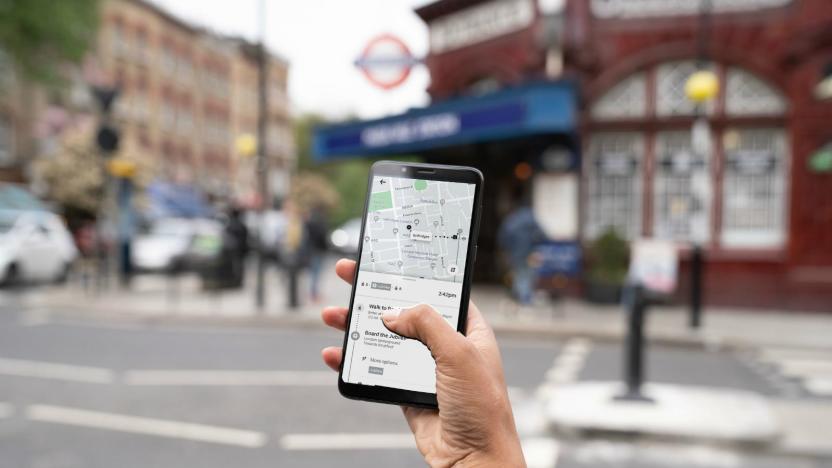
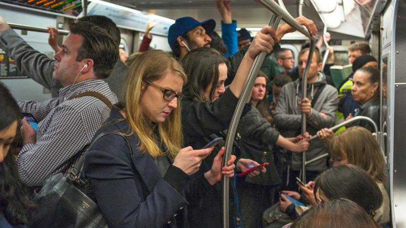
Uber adds London's public transportation info to its app
Londoners can now compare their public transport and ridesharing options in the Uber app. Tuesday, the company added real-time Underground, bus, train and Docklands Light Railway (DLR) info to a new "Public Transport" feature, which appears next to the UberX and UberPool options. When users search a destination, the app now generates a list of the fastest public transit routes, real-time schedules and walking directions to and from stations or bus stops.

Apple could make the iPhone's NFC more useful at WWDC
Apple has a lot in the cards for WWDC, and that might include improvements for... well, cards. The 9to5Mac team and Steve Troughton-Smith claim to have details of developer-friendly updates that will be unveiled in early June, and NFC support would be in line for a serious upgrade. App developers will finally have the option to read NFC tags based on ISO 7816 (usually ID and access cards), FeliCa (Japan's tap-based system) and MiFare (a popular mass transit format). In other words, you might use your iPhone to enter your office or hop aboard a bus in many cities.

Apple Pay for public transit coming to the US later this year
Apple announced today that Apple Pay will be coming to mass transit systems in major US cities later this year. Portland, Chicago and New York City will be the first to support the payment service, which will allow passengers to quickly pay fares with their iPhone.

'Brand New Subway' game lets you redesign NYC transportation
Despite the robustness of New York City's famous subway system, every rider will lose their patience at some point or another. High fares! Inconveniently distant stops! Irregular schedules! Good news, grumbling commuters: now you can redesign the city's public transportation with the Brand New Subway game.

Garmin, Navigon GPS apps now consider mass transit, remember where we parked
Third-party navigation apps still tend to fall apart when the keys are out of the ignition -- try to cut back on car use and you're often kicked over to another app with its own set of rules. Both Garmin's StreetPilot Onboard app and its Navigon equivalent are getting a much more holistic experience through respective upgrades due this fall. Android and iOS users alike can soon buy an Urban Guidance pack that factors buses, subways and other forms of public transportation into their on-foot routes. The playing field is leveling off for drivers willing to stretch their legs, too: iPhone owners with Navigon's app get the same last-mile walking directions and parking finder as their Android counterparts. StreetPilot iPhone app users are left out of this last addition, but they'll see compensation in the form of an optional Panorama View 3D mode and the Google Street View they're about to lose from Maps in iOS 6. The updated titles will still cost $30 for Navigon-only regional packs, $50 for editions with US-wide maps and $60 for all of North America, although you'll need to spend $5 more ($3 during the first two weeks) for Urban Guidance and $10 for the Panorama View 3D pack.

Google Maps notches one million public transit stops worldwide, celebrates with an update
It's no secret how useful Google Maps can be when traveling in an unfamiliar locale -- especially in regards to public transportation. The folks in Mountain View have tallied over one million stops for bus, train, subway and tram systems in about 500 cities around the globe with the software. To celebrate the achievement, Google has released an update to its Maps for Android app. Version 6.10 adds some tweaks to the Transit Lines layer in order to display just one individual method of transport and updated the station pages to display needed information like departure time and lines of service in a more accessible fashion. Also among the new additions are modifications to region highlighting, My Places and Location History. Now, when you enter a city name or zip code, the boundaries of that particular region will be marked for visual reference. For a full rundown of the latest version, hit the first source link below or sprint on to the second to grab the update. Update: Oh look, Mountain View's even tweaked the icon, which we've added after the break.

MBTA and Masabi team up for first smartphone rail ticketing system in the US, launching in Boston this fall
In Boston this fall, you won't need to keep up with your train ticket anymore -- as long as you don't leave your smartphone at home. The Massachusetts Bay Transportation Authority (MBTA) and Masabi have joined forces to bring a rail ticketing to handheld devices via iPhone, Android and BlackBerry apps. Headquartered in London, Masabi has launched similar tech for transit companies in the UK, eliminating ticket lines for many smartphone-wielding passengers. Software will allow riders to purchase tickets and passes that are validated with a barcode scan by conductors equipped with mobile devices of their own. MBTA is looking to cut costs and provide added convenience with the new system instead of adding more ticketing kiosks to its stations. The aforementioned apps will be developed alongside focus groups and a small pilot group this summer with a full rollout to all MBTA customers expected to happen this fall. Looking for a bit more info? Hit the coverage and source links below to read on. [Image credit: Masabi on Flickr]

Nokia Public Transport for Symbian shows you the way, can't guarantee a seat
Nokia's free turn-by turn navigation is great when you're lost, but what if you need to negotiate an unfamiliar train or bus system? Perhaps Espoo's new Public Transport app with its journey planning information for nearly 80 cities and urban areas (including London, Helsinki, Austin and Toronto) will see you right. What's more, you can even save your favorite destinations to the app's home screen to save a bit more tapping and typing. The app's only available for those freshly updated Symbian Belle phones right now, but it's free, and there's a Lumia-friendly version in the works. Sound like this might take the headache out of your daily commute? Then tap the source link below for more info.

Update to Google Maps improves battery life, public transit options and more
A new version of Google Maps has hit the Android Market today, which simultaneously brings fresher location tracking within Latitude and better battery life -- two welcome improvements that seem contrary to one another. There's also a couple goodies included for the transit-minded folks, as Navigation has been updated to better estimate location when GPS signal is lost, and the number of route options for public transit users has been increased from three to four. Sure, the changes are rather incremental, but who's honestly going to argue with greater battery life? Not us, that's for sure.

BYD opens North American HQ in LA, electric bus headed for LAX
China's BYD Motors has been edging its way into the North American auto market for some time, but it's now firmly planted itself here by opening its new headquarters in Los Angeles. That bit of news also just so happens to coincide with the announcement of a new partnership with Hertz Car Rental, who will be using BYD's all-electric, long-range eBUS to shuttle passengers at Los Angeles International Airport -- BYD's cars will also eventually find their way into Hertz's LA rental fleet. The press release is after the break.

Auckland amps up free WiFi for Rugby World Cup
Just in time for play-by-play tweets about the Rugby World Cup in New Zealand, Auckand has instituted a fully-integrated WiFi network across its Link public transit system. According to officials, buses and some trains will get the free internet treatment, giving passengers up to three 30 minute sessions a day between September 1 and October 31st. Powered by Tomizone and sponsored by Localist, the network promises 2 - 6Mbps downloads and is based on point-to-point links around town using fiber assets for backhaul. If that wasn't enough connectivity, CallPlus and Slingshot are dishing out some gratis WiFi of their own with an additional thousand hotspots sprinkled throughout the city. Hopefully, the added infrastructure will mean WiFi access par excellence year round for maximum non-Rugby related tweetage. Check out the full PR after the break. [Thanks, Scott]

Garmin launches StreetPilot onDemand iPhone app, offers transit schedules
Garmin is best known for its in-car navigation systems, but today delved deeper into the realm of personal navigation with a brand new iPhone app for the eternally lost. For a dollar, you'll get standard walking, driving and public transportation directions, but go premium for $2.99 a month or $29.99 for the year, and you'll cop more add-ons designed to transform your iPhone into a full-fledged PND. Like the standard iPhone mapping system or HopStop, the subscription-based version of this app lets you integrate public transportation into your journey -- but the added feature here is the ability to view public transit schedules like you can in the Google Maps app for Android. It also has spoken turn-by-turn directions, Garmin's traffic routing and Google search, making it a handy alternative to a clunky navigation system. Check out the full PR after the break.

Mapnificent visualizes public transportation travel time, is more exciting than it sounds (video)
If we could find a browser Mapnificient worked in without problems we'd probably call it the greatest thing to happen to Google Maps since turn-by-turn navigation. Even with it's painfully slow performance (Firefox) and tendency to crash (Chrome), we're still in love. Basically, it lets you filter and search maps based on travel time using public transportation. Its great for finding apartments with the shortest commute or a fair meeting place that you and a friend can reach at the same time. It's pretty impressive and, if its creator Stefan Wehrmeyer ever whips up a mobile app, it could become an indispensable part of our smartphone arsenal. For a much better and more thorough explanation by the developer himself, check out the video after the break.

Live transit updates in Google Maps help you plan your romantic bus-catching sprint
Brooklynites on their way to the latest Reggie Watts show have long had real-time bus-tracking information, but public-transit aficionados in six other cities now have one less reason for BK envy. With the latest version of Google Maps, even the least cool citizens of Boston, Portland, Ore., San Diego, San Francisco, Madrid and Turin can see not just when their bus or train is scheduled to arrive, but when it actually will. Selecting a stop on the map displays "live departure times" and service alerts, thanks to Google's data-sharing partnerships with city transit operators. That won't always guarantee fewer delays or less waiting, but will help riders budget their time, and maybe find those precious seconds necessary to post more Tumblr pictures of "ironic" Hitler-kittens.

Nissan NV200 van named NYC's 'Taxi of Tomorrow,' Travis Bickle cringes (video)
New Yorkers, this is your "Taxi of Tomorrow." After two years of deliberation, Nissan's NV200 was chosen as the city's exclusive taxi yesterday, edging out models from Ford Motor Co. and Turkish manufacturer Karsan. The four-passenger van is slated to hit New York's streets in late 2013, after which it will be gradually phased in on a more widespread basis. With a manufacturer suggested retail price of around $29,000, the commodious NV200 boasts a 2.0L 4-cylinder powertrain, transparent roof panel, driver navigation system, overhead reading lights and a mobile charging unit, replete with a 12V outlet and two USB ports. Nissan also placed an emphasis on passenger and pedestrian safety, with front and rear-seat curtain airbags, standard traction control and an external lighting system designed to alert others when the NV200's doors are opening. The van's microbial seat fabric should help assuage the fears of many germophobes, while its "low-annoyance" horn promises to put a (probably miniscule) dent in the city's noise pollution. Mayor Bloomberg definitely won't realize his all-hybrid dreams by 2012, but Nissan has agreed to participate in a forthcoming EV pilot program, involving up to six of the company's electric LEAFs. Until then, New Yorkers will have plenty of time to get used to the city's new soccer mom approach to taxi transport. Cruise past the break for full PR and video.

Android tablets bring touchscreen connectivity to Indian bus riders -- still no $35 slates in sight (video)
That's right, that little green blob in the upper left hand corner of that built-in touchscreen is indeed the Android logo, and that display does indeed belong to a tablet of unknown origin, currently riding around on the back of a headrest on a bus somewhere in India. We're not entirely sure who's funding this project or which bus line the tablets can be found on, but the login screen you see here does give us a little bit of insight: "As per government policy, we need to record details of the person using the Internet on this device." The service is apparently free and unlimited, and if this is a government program, it would be right in line with India's democratic outlook on technology. Sure, Indian college students are still awaiting the storied $35 tablets, but we suppose if they have enough scratch to ride the bus all day, these headrest slates could do in a pinch. For a look at what Android tablets look like on public transit, check out the video after the jump. [Thanks, Kartik]

Brooklyn bus riders get real-time bus tracking via cellphone
New York's Metropolitan Transit Authority launched a pilot program a few months back that offered bus riders some real-time tracking information, but it's now expanded things with a whole new program on the B63 route in Brooklyn. That service is currently accessible via a mobile-friendly website or text message, and smartphone users can also scan simply snap a picture of a barcode (presumably a QR code) at a bus stop to immediately check in on the location of the next five buses that will arrive at the stop. What's more, unlike the previous program, this new system is based on an open source platform developed with the help of OpenPlans, and the MTA is actually encouraging developers to dig into the API and develop their own solutions -- which could certainly get interesting as the program is expanded across the city (the Staten Island bus line is next up). Head on past the break for the MTA's press release, and hit up the link below to try out the service right in your browser.

FTA awards $16.6 million in grants for fuel cell bus research
While we were jealously hung up on South Korea's working electric bus system, Christmas apparently came early for a couple of lucky US fuel cell bus research projects -- in the form of $16.6 million in Federal Transit Administration grants. Pasadena based Calstart snagged almost $10.2 million and will funnel 70 percent of the funds to developing the first phase of a low-cost, longer lasting fuel cell power system. Calstart will then spend its remaining $2.9 million in partnership with the Chicago Regional Transit Authority to develop and test the viability of fuel cell bus fleets in cold climates. The Center for Transportation and the Environment in Atlanta was the other project to hit the federal money gravy train. It received a hefty $6.4 million to spread across six different projects that dabble in everything from developing fast-charging 35-foot fuel cell buses, to similar lithium ion versions, to improving existing hybrid bus platforms. Federal pork for fuel cell DSLR development regrettably missed the cut. For the full scoop hit up the press release after the break.


