satellite
Latest

The first 8K satellite TV broadcasts launched today in Japan
As scheduled, at 10 AM local time on December 1st Japanese TV networks began publicly broadcasting 4K and 8K channels via satellite. Even after a couple of years of testing, NHK is currently the only one pushing content at 8K with 22.2 channel sound. The first movie listed in its TV guide is 2001: A Space Odyssey, and the BBC reports that Warner Bros. rescanned the film's original 70mm negatives specifically for this broadcast.
SpaceX revises internet satellite launch plan to minimize space debris
For the past few years, SpaceX has been working on its Starlink project, the goal of which is to launch thousands of low-orbiting satellites that will provide high-speed internet to people around the world. In February, the company put two prototype satellites into orbit, which it has used to test the technology ahead of a full deployment of its satellite constellation. But while those satellites were supposed to begin moving to a higher altitude than where they were initially placed, they haven't. And it looks like that's because SpaceX is slightly revising its launch plan.

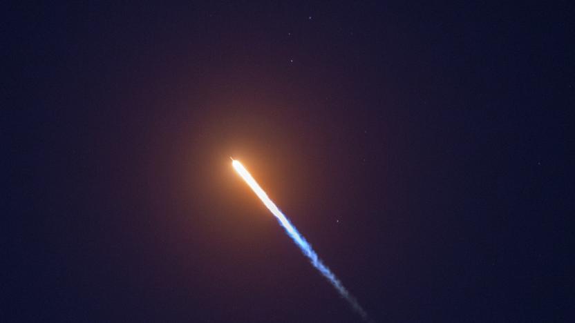
China's first private satellite launch ends in failure
China's young private spaceflight industry has enjoyed some success, but it's still facing setbacks. The first private attempt at a satellite launch failed on October 27th when the third stage of LandSpace's Zhuque-1 rocket didn't reach orbit. It's not certain what led to the failure. However, the vehicle was carrying a commercial satellite for the state-owned network CCTV.

Russia balks at US-run OneWeb satellite internet over security concerns
Russia's Federal Security Service (FSB) has thrown a wrench in a planned deal that would bring internet access to the most rural and remote parts of the country, according to Reuters. United States-based startup OneWeb was set to launch a satellite project that would provide an internet network for Russia, but the plans have been delayed over the FSB's concerns that the company will gather intelligence and threaten the country's national security.
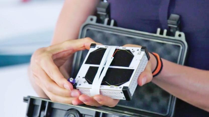
Rogue satellite startup gets the launch license it needed first time around
Sending things to space is a serious business that normally requires capital investments, rigorous preparations — and taking care of the paperwork. Earlier this year US startup Swarm circumvented the last part and sent a series of probes — so-called SpaceBEEs — into orbit despite being rejected for an FCC license. Although FCC is still looking at how to punish the rogue operator, it has just granted it a temporary license to send up a few more satellites.

NASA's pint-sized satellite could improve weather forecasts
Apparently, NASA has been testing a small, shoebox-sized satellite that could make weather forecasts a lot more accurate. It's called RainCube for "Radar in a CubeSat," and it uses tiny instruments to provide real-time look inside storms. The agency has deployed the test unit from the ISS into Low Earth Orbit in July, which captured its first images of a storm over Mexico in August. In September, the satellite also captured images of Hurricane Florence's first rainfall. In other words, the experiment has been successful, though most likely far from over. See, the hope is to use a whole fleet of RainCubes to monitor severe storms.
NASA will launch its ice-tracking satellite ICESat-2 on Saturday
On Saturday, NASA will attempt to launch its Ice, Cloud and land Elevation Satellite-2, or ICESat-2, a satellite that will help researchers measure the height of natural features on Earth. With the help of a powerful on-board laser, ICESat-2 will measure changes in Earth's ice across seasons and years. "Retreating glaciers. Shrinking sea ice. Melting ice sheets. The frozen reaches of Earth are changing at dramatic rates," NASA said, "and the impacts, from sea level rise to altered weather patterns, span the planet." So ICESat-2's mission is to collect incredibly precise measurements of Earth's ice as well as the heights of other features like forests, oceans and clouds.

UK reportedly plans its own satellite navigation system
Now that the UK likely won't be involved in the EU's Galileo positioning satellites, it's in a tough spot. How does it get the most accurate navigation technology it can once Brexit is official? By building its own satellite network, apparently. Sources talking to The Telegraph claim that Prime Minister Theresa May has ordered the creation of a UK-built satellite positioning system, with up to £100 million (about $128.5 million) set aside for "mapping out" how it would work.
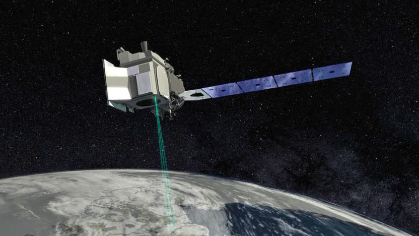
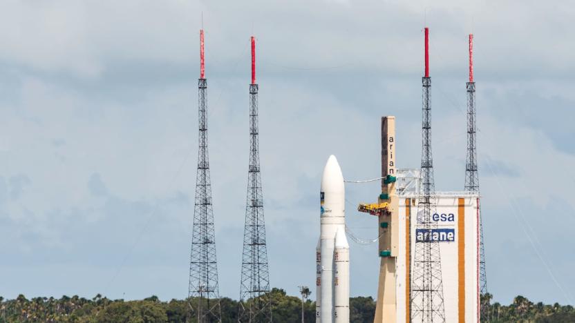
Watch the ESA launch its wind-mapping Aeolus satellite at 5PM ET
The European Space Agency is launching its Aeolus wind-mapping satellite today from the Guiana Space Center in Kourou, French Guiana. Once in orbit, Aeolus will measure winds from the Earth's surface up to the stratosphere using powerful lidar technology, and it will do so on a global scale. The data Aeolus collects will help improve weather forecasting and provide valuable information for climate change research.
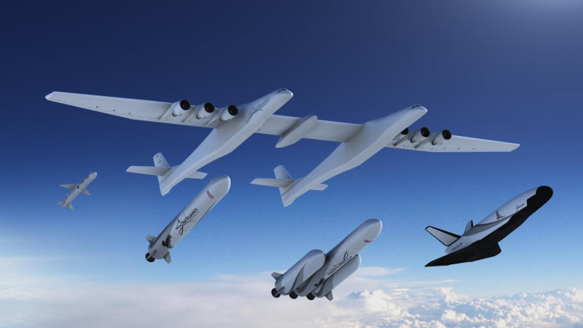
Stratolaunch's new satellite carriers include a reusable space plane
Paul Allen's Stratolaunch is only just starting to make serious progress on its massive aircraft, but it's already thinking about its future beyond that enormous machine. The company has unveiled a new family of launch vehicles that can carry a wide range of payloads to orbit. Most notably, it's in the "design study" phase for a completely reusable space plane (shown at far right). Stratolaunch won't even predict when the machine would be ready, but it would initially focus on cargo launches and carry crew in later revisions.

NASA helps businesses make use of its satellite data
NASA has made its raw satellite data widely available for a long while. Now that it has a privatization-minded leader, though, it's looking to make that data more palatable for the business crowd. The administration has released a Remote Sensing Toolkit that should make it easier to use observational satellite info for commercial purposes, including straightforward business uses as well as conservation and research. The move consolidates info that used to be scattered across "dozens" of websites, and helps you search that unified database for helpful knowledge -- you don't have to go to one place for atmospheric studies and another to learn about forests.

Facebook hopes to launch an internet satellite in early 2019
Facebook has cooperated on internet satellite initiatives (with less-than-ideal results), but there's been precious little word of plans to make its own satellite beyond high-level promises. Now, however, there's something tangible. Both publicly disclosed FCC emails and a direct confirmation to Wired have revealed that Facebook aims to launch an internally developed satellite, Athena, sometime in early 2019. A spokesperson didn't share details, but the shell organization Facebook used to keep filings hidden (PointView Tech LLC) talked about offering broadband to "unserved and underserved" areas with a low Earth orbit satellite on a "limited duration" mission.
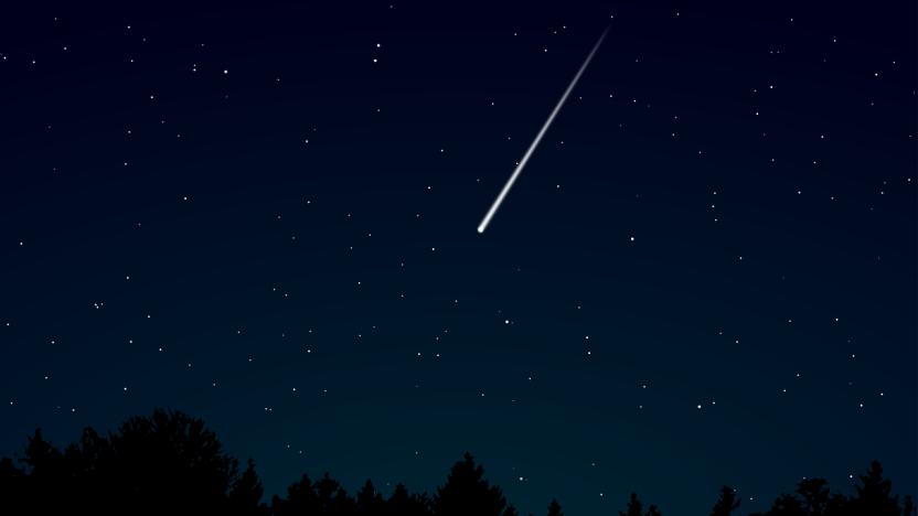
Artificial meteor shower displays are coming
Fireworks. So passé, right? That could well be the thinking of one Japanese start-up, which is developing shooting stars on demand, and plans to put on the world's first artificial meteor shower in early 2020.
DARPA wants better forecasts for near-Earth orbit space missions
DARPA, the government's mad science wing, wants "weather" forecasts for outer space like we've got here on terra firma. The idea is that as we're increasingly launching satellites into low-Earth orbit -- not to mention prepping for commercial spaceflight -- we'll need the ability to predict smaller space weather events as well as big ones.
Google works with the UN to monitor environmental changes
Google is partnering with the United Nations to help measure the impact of human activity on ecosystems around the world. The project, which launches today, will provide real-time data to organizations and countries looking to plan and direct actions in response to quickly changing environmental conditions. The goal is that, with free access to this valuable data, more countries will pursue sustainable development.
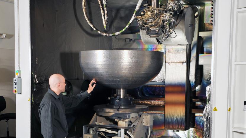
Lockheed Martin creates its largest 3D-printed space part to date
Lockheed Martin has just finished the final series of quality control tests for an enormous titanium dome meant to serve as caps for satellite fuel tanks. It's not just any ordinary dome, though: the enormous component measures four feet in diameter and is the company's biggest 3D-printed space component to date. Its previous largest qualified space part is an electronics enclosure that's around the size of a toaster. This dome is large enough to seal fuel tanks bigger than humans and, according to Lockheed Martin, big enough to hold 74.4 gallons of coffee or 530 donuts. Glazed, of course.
UK won't be involved in Europe's Galileo satellite navigation program
Among the many projects being shaken up by Brexit is the European Union's Galileo program, a satellite-based navigation system along the lines of the US' GPS. It's scheduled to be operational in 2020 and will be used by citizens, military and governments. Though the UK has already put £1 billion toward the project, the country's decision to leave the EU has put its involvement with the Galileo program up in the air -- the EU has been clear that the UK might be shut out from the project since fully including a non-member state would threaten the security of the system as a whole. Now EU members have voted to do just that.
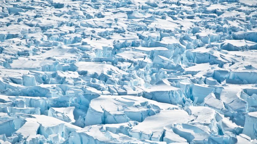
Antarctica is losing ice at an increasingly rapid rate
Antarctica is losing ice at an increasingly rapid rate, according to a new study published today in Nature. More than 80 researchers from 42 international organizations presented findings that show between 2012 and 2017, Antarctica's ice sheet lost 219 billion tons of ice per year -- triple the rate prior to 2012. Between 1992 and 2017, ice losses in the region contributed to a global sea level rise of 7.6 millimeters, with forty percent of that rise occurring in the last five years alone.
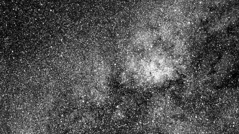
NASA's planet-hunting TESS spacecraft snaps its first photo
TESS, NASA's new exoplanet-hunting spacecraft, has captured its first image ever, giving us a glimpse of what its powerful "eyes" can see. The spacecraft's science team used one of its four cameras to snap a two-second test exposure as part of their preparations now that TESS is only a month away from officially starting its science operations. Their photo shows over 200,000 stars with the southern constellation Centaurus at the center and one of the brightest stars in the night sky, the Beta Centauri, visible on the lower left edge (see the full image below the fold).
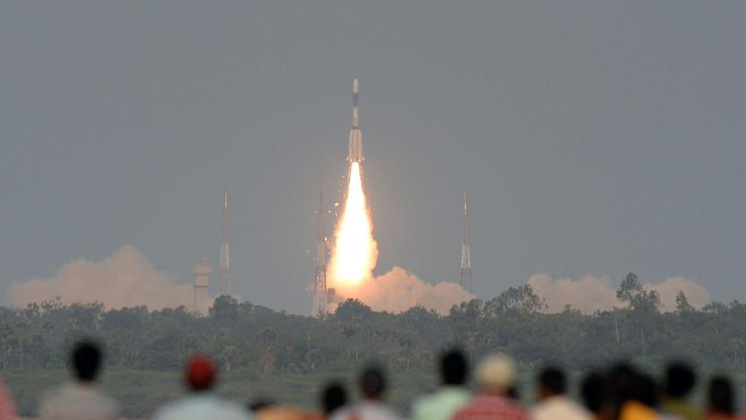
India loses contact with a recently launched satellite
On Thursday, the ISRO (Indian Space Research Organization) launched the GSAT-6A, the country's most powerful communications satellite to date, into orbit. Yesterday, the organization confirmed that it had lost contact with the satellite, possibly due to a failure in the power system, according to the Times of India.


