Citymapper
Latest

Citymapper launches a transit-only payment card for London
Like many big cities, navigating London can be a struggle, with the sheer volume of transit options being confusing. Its maps, though beautiful, can be misleading to tourists and those passing through, which is why apps like Citymapper exist. The app examines every form of mass-transit available to help you plan the most efficient route, and now it's looking to help you pay for it, too.
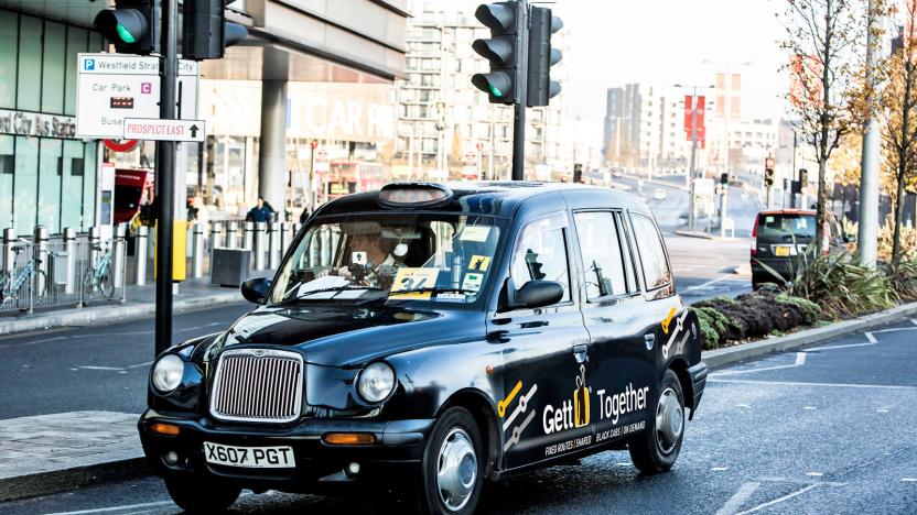
Gett is using Citymapper data to plot new ride-sharing routes
London's public transport system is pretty robust, with plenty of Tubes, buses and overground lines zig-zagging across the city. At rush hour, though, squeezing onto a crammed DLR carriage can be a total nightmare. One alternative is a taxi-hailing app like Gett, which for some time now has been pushing Gett Together, a ride-sharing service that operates on preset routes across the city. Today, the company is announcing Black Bus 1, a new route that operates between Highbury & Islington and Waterloo. The expansion is notable because it was designed using data supplied by mobile navigation app (and now bus route operator) Citymapper.

Citymapper to launch a weekend night bus service in London
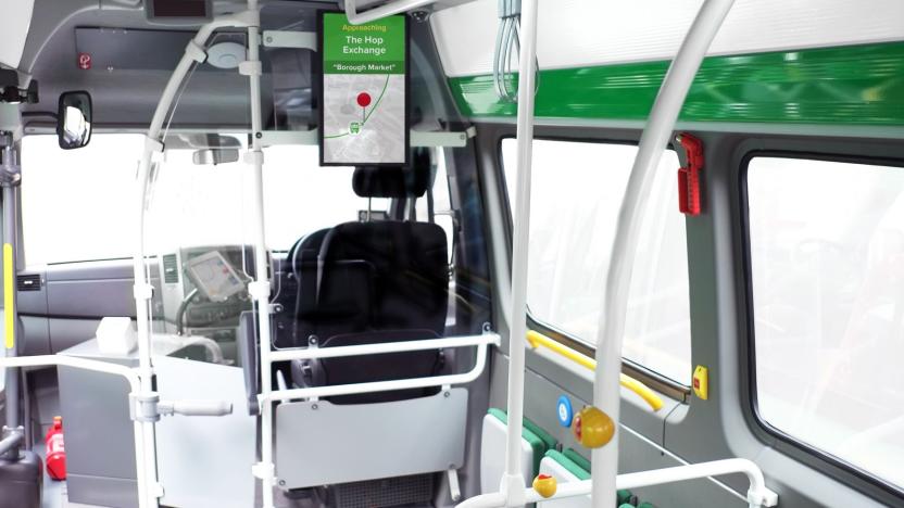
Citymapper's brief bus experiment in London was more than a one-off. The company, which runs an independent transport and navigation app, is now planning a permanent bus route in the middle of East London. Like its two-day trial in May, the new service will utilise bright green buses equipped with USB ports for charging (a godsend when you're traveling home at the end of a long day) and a big screen upfront with regularly updated route information. Unlike before, however, this service won't be free; you'll have to pay a small fee with a contactless card, Apple Pay or Android Pay.
Route planner Citymapper experiments with its own bus service
Citymapper is known for its popular route-planning app that helps people get around town. This week, though, the company is taking a more active approach to transportation, operating an actual bus route in London. CMX1 will only run from Tuesday, May 9th, through Wednesday, and it'll be free for all passengers. As you'd expect, it'll also feature in the Citymapper app and show up in route suggestions where appropriate. But what might surprise you is this isn't quite the marketing stunt it appears at first to be. Citymapper is legitimately thinking about becoming a public transportation player.

Uber is deeply integrating with other apps
Uber has been pushing to get its services better integrated into third-party apps in recent years, and new widget and branding features will bring a more complete experience than ever before.

Citymapper travel app tells you the best place to get on the train
While Apple and Google are incorporating more public transport data into their operating systems, standalone apps like Citymapper continue to lead the way in terms of features. Already in 28 cities, the travel app combines bus routes and live times, train timetables and cycle paths, but from today it'll also help you navigate your way around an unfamiliar metropolis with its new "Where to Get On the Train" feature.

MTA, AT&T declare winners of transit app contest
New York's Metropolitan Transportation Authority (MTA) and AT&T announced the winners of the 2013 App Quest challenge this week. The challenge was designed to highlight the best mobile apps for the millions of MTA customers who tote up to an impressive 2.6 billion trips each year on the MTA's buses, subways and commuter rail trains. Best Overall App went to the developers of Citymapper (free), which provides real-time information on subways, buses and even bicycle sharing in New York City and London. The developers won US$20,000 for the app, which not only provides transportation information but also local weather and information on shutdowns and service disruptions. It can even tell passengers when to get off a bus. The MTA fought third-party apps initially, but in 2010, it decided to work with developers and started making information on scheduling, ridership and route performance freely available. The App Quest competition is in its second year -- last year's winning app, Embark (free), was acquired by Apple last month.

Going to the London Olympics? Here are the transport apps you'll need
The London 2012 Olympics officially start in just under two weeks. From July 27th until August 12th millions of combined spectators, journalists, and the world's fittest athletes will descend upon the greatest city on the planet. During that time Transport for London estimates that there will be an extra four million visitors to the city. To put that in perspective, that's adding over 50% to the capital's normal population of 7.5 million. In addition, TFL estimates that up to one million extra people per day will be using London's transport systems. What does that mean? Chaos, basically (and a huge pain for the people who live here). But if you're going to be one of the four million visitors there is some hope. You can stock up on London's best transport apps that will help you navigate the city. Since I moved to London in 2007 I've tried virtually every London transportation app. In the list that follows, I've narrowed down the single best app from each category: tube, bus, car, bicycle, and boat. Tube: Tube Map Pro Hands down, Tube Map Pro by mxData Ltd is the best tube app out there. The app uses officially licensed maps from Transport for London that allows users to easily see an overview of the entire transport network and find out how to quickly get from one point to another. Besides maps and route planning, the app uses GPS to show you the closest station to you, features live departure boards, and lets you track the balance of your Oyster card (the Tube's ticketing system) right in the app. If you're visiting London, Tube Map Pro is the single best app purchase you can make. Tube Map Pro is discounted to US$0.99 in honor of the games. The app is universal, so it works on both the iPhone and iPad. mxData also has a free, ad-supported version of the app called Tube Map. Bus: London Bus Checker After the Tube, the mode of transport most visitors will be taking is the bus. London's bus network is excellent, and many times it's faster that the tube (when you take walking to stations into account). The best London bus app I've found is London Bus Checker by FatAttitude. The single best thing about this app is it lets you see, in real-time, when the next bus you need to catch is coming. If, for instance, your bus stop is around the corner you can check the app to see if the #55 is two minutes away and you need to run to make it, or if it's 10 minutes away and you can mosey on over at your own pace. Among the many other features, the app also offers stop alerts so you know when you're approaching your stop and lets you see full route maps for London's entire bus network. London Bus Checker is $2.99. It's also a universal app, so it works on both the iPhone and iPad. Car: Park-Up - London Parking Let me just say this right now: if you are planning to drive in the city during the London Olympics, you are crazy. Period. You'll spend more time sitting in traffic then you will seeing all the sights London has to offer. That being said, I'm sure there will be some people who will still think that driving is the way to go. In that case, iOS's Maps app is the best route planner for your transportation needs. However, just because Maps can get you there, it doesn't mean you'll actually find a place to park. That's where Park-Up's London Parking comes in. The app tracks over 10,000 places to park in central London, from single street parking bays to entire car parks and parking garages. What's really nice about the app is that you can view what kind of parking space it is before you get there. Tapping on any parking location will show you the hours and costs, and, if available, the number of spaces, height restrictions, and security arrangements. Park-Up London Parking is $4.99. It's also a universal app, so it works on both the iPhone and iPad. Boat: KPMG Thames Clippers A great way to get from one side of London to the other is by boat. The Thames is full of clipper ships that ferry people up and down the river. Many times, if you have to travel a long distance, this is actually the best way to go. Using KPMG Thames Clippers by Seligman Ventures, users can enter their start and destination piers and view the official timetables from Thames Clippers. Do note, however, that these time tables are not updated in real time. KPMG Thames Clippers is a free app for iPhone. Bicycle: Barclays Bikes Compared to cities in the US, London is extremely bike friendly (though it does have some catching up to do with its European neighbors). Chances are you won't be bringing your bicycle to London, but that shouldn't stop you from cycling around the city (which is probably the best, fastest, and funnest way to not only get around the capital, but to see it as well). Barclays Bank has a cycle hire program with the city. The program installed thousands of bicycles at spots around the capital that anyone can use. The first half-hour is free, and after that charges are relatively cheap. If you are going to be hiring Barclays cycles, you'll want to download the official Barclays Bikes app. The app shows you where the closest cycling docking terminal is, lets you calculate the cost of how much a bike hire will be (based on the time you plan to have it), and lets you plan your cycling route based on places, postcodes, or address. And the best thing about the app is it not only shows you how close the nearest cycling docking station is, but it also shows you how many bicycles are available at that station. Barclays Bikes is a free app for iPhone. Everything: Citymapper - London Transport All of the above apps are excellent for their chosen mode of transportation. But what if you want to get from one place to another and choose your mode of transportation based on time or cost? That's where Citymapper - London Transport by Citymapper Inc. comes in. The developers call the app a "Super Router" and boy, are they right! Just enter your start and end locations and Citymapper shows you a list of all your transport options including walking, cycling, bus, tube, rail, and cab. For each option, they also show you how much the journey will cost (or for cycling and walking, calories burned) and also how long the trip will take. Citymapper does note that the app is still in beta, but in my tests it works quite well. Citymapper - London Transport is a free app for iPhone. Check out screenshots from each app below and drop me a line in the comments if there's a London transport app you love that I didn't list. %Gallery-160395%


