GPS
Latest

Experimental navigation system swaps satellites for quantum physics
GPS can be useful when you're trying to navigate to that hot new bar -- as long as your travels don't take you somewhere its signal can't reach. A new so-called quantum positioning system could pick things up when satellites fail, and help guide your way using super-cooled atoms. Aside from better directions, the solution might even make travel safer. While existing accelerometer-based systems can track location underwater within a kilometer, quantum positioning can do it within a meter, making it 1,000 times more accurate. With submarines, that could be the difference between staying safe and drifting into hostile waters.

Russia threatens to disrupt GPS navigation in fight over sanctions
Hold onto your sat nav. The Russian government has just threatened to end cooperation with America on major space projects, including maintenance of the GPS system. The policy will also prevent NASA from accessing the International Space Station from 2020, as well as blocking the supply of components for America's Atlas V rockets, which are currently vital for sending military and commercial satellites into space. With regards to GPS, Deputy PM Dimitry Rogozin says that he'll shut down Russian base stations that keep the system going, unless the US promises to house reciprocal stations to support the competing GLONASS platform. He's quoted as saying that Russia is wary about developing future "high-tech projects with such an unreliable partner as the United States, which politicizes everything." Why the sudden burst of angry rhetoric? As you can probably guess, aside from the dispute over local GPS stations, it has everything to do with America's decision to impose sanctions on Russia, following Vladimir Putin's invasion of Ukraine.

Cyclist GPS data could help cities plan safer routes
Strava has been using GPS coordinates to monitor progress for cyclists and runners for quite some time, and now it's looking to lend a hand to local governments. With its new effort, Strava Metro, the fitness-tracking outfit serves up data on 90 million bike routes and 24 million runs (at launch) to help planners examine how the two segments use public roads. Oregon's Department of Transportation has already signed on as the first customer, using the info for a year -- a deal that carried a $20,000 price tag. What's more, London, Glasgow, Orlando (Florida, US) and Alpine Shire (Victoria, Australia) have also opted in. "Right now, there's no data. We don't know where people ride bikes," Portland State University professor Jennifer Dill told the Wall Street Journal. "Just knowing where the cyclists are is a start." Urban planners in cities have long had access to metrics around automobile traffic, but tracking patterns for bike and runners hasn't been available up to this point.

Google updates and improves Maps on iOS
If you already have Google Maps on iOS you'll see a significant update today to version 3.0. If you don't have it, the new features may tempt you to give it a try. Some highlights: Turn-by-turn navigation now offers lane guidance Travel time, distance and ETA are all on the main screen at the same time Contacts are now available through the app (hooray!) Voice search using Google Voice Search is now supported Maps can be saved offline to a custom list Although Apple stumbled early with its Maps, it has continued to improve. Google certainly wants to own the maps market on iOS, so they have been highly motivated to improve the app, and this update is very competitive. I tried the app on a short commute today and found it easy to use. I still prefer the Apple 3D road view, but Google Maps was easy to follow. Unlike Apple, you get a choice of satellite or drawn map views while driving. You can use Google Voice to find your nearest destination, and you'll get qualitative ratings of restaurants and retailers along with other points of interest. The voice for directions are clear, and the next turn on your route is bold and at the top of the screen. The app continues to work in the background. Transit results now display total walking time of your trip and the next scheduled bus or train, which is a very nice feature for urban users. I think I still prefer Apple Maps, mostly because of the easy integration with Siri, and the look of the display, but Google Maps is still the gold standard and they have improved an already excellent app with this update.

Engadget Daily: #AmazonCart, Oculus VR denies IP theft, and more!
You might say the day is never really done in consumer technology news. Your workday, however, hopefully draws to a close at some point. This is the Daily Roundup on Engadget, a quick peek back at the top headlines for the past 24 hours -- all handpicked by the editors here at the site. Click on through the break, and enjoy.

Garmin's latest bike computer talks to your gear shifter
Bike computers have been connecting to an ever larger sphere of devices, ranging from fitness sensors to smartphones. It only makes sense, then, that they integrate with the bike itself -- and Garmin is doing just that with its new Edge 1000. The device can tell what gear you're using when paired with Shimano's Di2 electronic shifter, and ties that info to your ride; it's now easy to figure out if dropping gears helped you conquer that hill a little faster. There are a few big upgrades over the Edge 810 that don't require high-end bike components, of course. The 1000 supports new Garmin peripherals that include both a handlebar remote as well as cadence/speed sensors, and you can share ride segments through the company's smartphone app if you want to prove your worth to nearby cyclists. This flagship Edge will be expensive at $600 ($700 bundled with sensors) when it ships later in the spring, but that premium may be worthwhile if you just have to get a competitive advantage over fellow pedal-pushers.

TomTom's new GPS watches track your heart rate without a chest strap (update: US pricing)
Now that smartwatches have built-in heart rate monitors, it's not enough for GPS watch makers to require a chest strap for the same feature -- they've got to step up. TomTom, at least, is ready. It just revealed the Runner Cardio and Multi-Sport Cardio, both of which improve on the original Runner watch by combining position-based exercise tracking with an integrated optical heart rate sensor. The new wristwear lets you train based on intensity, ranging from low-tempo warmups to full-on sprints. If that's the kind of fitness monitoring you've been craving, you can pre-order the Runner Cardio and Multi-Sport Cardio for £250 ($416) and £280 ($466) respectively. Update: TomTom has since given out US pricing: it'll cost $269 for the Runner Cardio, and $299 for its Multi-Sport sibling.

Slighty smarter watches: Casio reveals two new G-Shock concepts
G-Shocks are back -- again. Ready for Swiss timepiece showcase BaselWorld, Casio has announced two new analog concept watches with a little extra soupçon of tech crammed in. The designs still lean towards those looking for a classically-styled (at least, in G-Shock terms) analog watch. Both are expected to last plenty without any regular USB life-support, with the company's latest solar cells there to keep the mechanism and electronics going. First up, the Edifice EQB-500 connects to smartphones using Bluetooth 4.0 Low Power (Casio's first analog watch to do so). It's a loose allegiance though, covering time information and alarm settings which can also be programmed through the phone -- it's still very much a watch, not a Pebble rival. Casio's second model is the more technically accomplished one: the first watch to pair together both GPS and Radio Wave tech, all without any unwieldy lumps in the design.

The i'm Tracer bracelet means never having to ask 'where's the kid?'
The kooky folks behind the (frankly awful) i'm Watch are a mainstay at Mobile World Congress. This year they've got something a little more useful to show off: It's called the i'm Tracer, and it's the evolution of another GPS tracker the company has highlighted before. The Tracer is a wearable mash-up of a GPS module and a GSM radio the Italian company hopes will help you keep tabs on your kids when it launches this summer.

Nokia Here Maps coming to all Windows 8.1 devices
Have you looked on with envy as friends with Lumia 2520 tablets use Here Maps to navigate around city streets? You won't have to for much longer. Nokia has revealed that it's bringing the mapping software to all Windows 8.1 PCs, including RT-based systems. The wider availability will come alongside a host of upgrades, too. In addition to the necessary additions of mouse and keyboard support, you'll also get a search history, higher-resolution satellite images and faster map loading. Nokia will offer the app for free, beginning with those in North America and Europe; everyone should have access within a few days.

Garmin's Fenix 2 GPS watch can track your sporting life and talk to your phone
Garmin's original Fenix GPS watch was nearly a one-trick pony -- it could guide you through a hiking trip or a long run, but not much more. The company's newly unveiled Fenix 2 is considerably more talented, however. The new wearable can track your progress in six sports, with automatic recording for certain activities; it's smart enough to know that you've completed a ski run or a lap in the pool. It also includes an accelerometer to help with indoor tracking. The device even takes on some smartwatch duties by letting iPhone owners receive notifications for calls, email and texts. While the Fenix 2 will carry a steep $400 price ($450 with a heart rate monitor) when it ships in March, it might be the only smart wristwear you need if your life revolves around fitness.

Tinder security flaw exposed users' exact locations for several months
Have you been using Tinder (an iOS/Android dating app that shows pictures of users in your area) these past months to try and find the one? Well, if you're deathly scared of stalkers, you might want to sit down. Apparently, there was a flaw on the dating app's API, which made it possible to pinpoint user distances down to a hundred feet. According to a report published by whitehat hacker Max Veytsman from Inside Security, he discovered the vulnerability in October 2013. It could've been around since July, though, as it was a byproduct of the fix issued for a previous flaw that revealed users' latitude and longitude coordinates. To demonstrate how damaging the security loophole could be, Veytsman created an app that automatically shows a user's location on Google Maps by using triangulation, as you can see in the video after the jump. Thankfully, Tinder's management was more receptive to feedback than Snapchat's, and though Veytsman didn't receive a reply to half his emails, tests he conducted on January 1st revealed the issue no longer exists. Now, we can only hope no ne'er-do-well had any success matching up Tinder addresses with Snapchat phone numbers.

Google's Field Trip app adds ratings to its recreational recommendations
Google knows that not everything in Field Trip will reach the high watermark of creepy areas around New York, but it hopes that the app's latest update will make cool spots easier to find wherever you are. The search giant's Niantic Labs has added a rating system on Android and iOS and is enabling the community to possibly cull banal info from the mobile point-of-interest database. The five-star rankings should offer more granularity than the previous thumbs-ups/thumbs-down system, and soon enough the cards with the highest average score could be all you see. If your city is inherently boring though, there's nothing Mountain View can do about that.

Localscope for iOS gets an update and continues to provide great location based info
Localscope (US $2.99) has been around the app store for quite awhile, and continues to get updates that make the app a great way to explore your surroundings without moving an inch. This latest update tweaks the GUI and adds geo-tagged video resources from YouTube. While some discovery apps give you loads of text, Localscope provides geo-tagged media files to show your picture, maps and videos, and then provides direction pointers to destinations. When you are ready to leave, you can navigate by direct linking to almost every navigation app available, including, of course, Apple and Google Maps, TomTom, Garmin, Navigon, Waze and dozens of others. The app integrates info from Google, Facebook, Foursquare, Twitter, YouTube, Instagram, Yelp, Citysearch and many more. It works anywhere in the world, and has built-in support for 21 languages. You can search by category (museums, restaurants, locksmiths, etc.) or you can type in any business name or destination. Destinations can be saved to your address book, or shared with friends via email, Facebook and Twitter. It's a very complete one-stop place to find, see and hear about things around you. The app allows you to set geo-tagged reminders, and get notified when approaching or leaving a destination. One of my only criticisms of the app, and they are mild ones, is that there are a lot of nested screens. I'd like to see more info come up on the main screen to reduce clicking. I also see context-sensitive ads coming up. They might be helpful to some, but this is a paid app and I think there should be an option to eliminate them. To me, they are unwanted and uninvited clutter. If you are going to fill an app with ads, then make the app free. Localscope is not a universal app; it's designed for the iPhone and requires iOS 7.0. Localscope is optimized for the iPhone 5 and above.

Ex-Ubisoft devs unveil ReRoll, an ambitious stab at turning reality into a game
For years, games have repeatedly tried to outdo one another in the quest for the most expansive, interactive open-world experience possible, but what could offer more true freedom than our own planet? That's the basic idea behind ReRoll. In development at Pixyul, a new studio created by two former Ubisoft developers, ReRoll uses civilian aerial drones to capture images from all over the globe which are then stitched together to create the in-game world. Further, ReRoll employs a "Reality Sync System," that takes real-time environmental data from our reality and feeds it into the game. If it's snowing in Chicago, ReRoll's virtual rendition of the Windy City will likewise be blanketed in fluffy white flakes, Pixyul claims. Little is known of ReRoll's gameplay, though its developers describe the game as a survival action-RPG. "To subsist, you need to eat, rest, exercise, learn, fight but most of all find all the different ways to survive," reads the game's official description. While no release date has been established for ReRoll, Pixyul has set up a crowdfunding effort on the game's website. As with most fundraising attempts, those who contribute money to the development of ReRoll will earn exclusive swag in exchange for their blind faith in the project - in this case, weaponry and vehicles to be used in the game. [Image: Pixyul]

Altitude - View & Share for iOS reports your current altitude
Altitude - View & Share for iPhone (free) is an interesting little app that reports on your current altitude. Once launched, the app displays your altitude in meters or feet over a landscape photo meant to represent your surroundings. With a tap, you can share this information with family or friends via Facebook or Twitter. That's great, but what if you want to use your own photo? An in-app purchase (US$0.99) unlocks this feature. Once bought, you can save a custom image with altitude information intact to your iPhone's camera roll. The option of using your own photo is a nice touch. Still, I wish I could share via email from within the app. As it is, you have to make a trip to your camera roll. That seems a weakness in an app that bills itself as a sharing solution. I also wish I could choose an existing photo. Altitude requires you to shoot a new one. (The author of the software says that function is in the app. I didn't find the control obvious, but it is there.) Finally, the built-in photos slowly pan left and right, while custom pictures remain static. I like the idea behind Altitude. It's great for sharing your travels, especially in the mountains. Of course, a trip to some parts of Death Valley will give you some below-sea-level readings. A similar, free app is Travel Altimeter Lite. It displays altitude, latitude and longitude over a picture, but if you want more variety, you'll need some pricey in-app purchases that total more than the $0.99 upgrade for Altimeter. Altitude needs iOS 7.0 or later. It supports English, French, Spanish and Italian. It's not a universal app, but it is optimized for the iPhone 5.

This smart handbag could stop you from overspending
If you're the sort who overspends at the mall, you may need a firm reminder to watch your budget. How does an ever-vigilant handbag sound? Finder.com.au could soon make one: meet the iBag, a prototype carryall that locks you out if it believes you're going to splurge. The Arduino-powered bag automatically shuts tight at those times you're most likely to shop. Outside of those moments, it uses GPS to warn you when you get too close to favorite stores; ignore the alert and it will both record when you take out your wallet as well as send a text message to a trusted partner. iBag is primarily a publicity stunt meant to highlight the dangers of credit card debt, but it might become a reality. The site is asking potential customers to register their interest, and it may sell both men's and women's versions of the bag for $199 AUD ($173 US) if there's enough demand.

Maps With Me Pro: Offline maps for anywhere
The most popular mapping programs, like Google Maps and Apple Maps, are great as long as you have a data connection on your iOS device. But if you are a traveler and get off the beaten path, you can be stuck with a blank screen on your iPhone or iPad. Maps with Me Pro solves that problem, giving you access to "everywhere" for a one-time US$3.99 purchase. The app covers 345 countries and islands, and your one-time payment lets you download maps for any of those locations. Also included is a very complete point-of-interest (POI) database. As noted, the app works without any internet connection, and maps draw quickly and zoom quickly. The app supports bookmarks and location sharing, so you can send your location to a friend (for that, you'll need a data connection, of course). I live in Arizona, so I downloaded the Arizona map for testing. That took about 30 seconds over WiFi, and if I was going on a trip, I would just download maps for my destination prior to leaving. Using Maps With Me Pro is simple, but it is not a navigation app in the traditional sense. If you find a museum you want to visit, for example, you will see your location and the museum on the map, but you won't get turn-by-turn directions. The map keeps your location on screen when you are moving, so it's not to difficult to get somewhere. Zooming is infinite: As you zoom out, you will see the whole world, and as you zoom in, you will get some details. But if you zoom in even more, you'll be asked to download the appropriate map. I gave the app a tough test: Pitcairn Island, which figured in the famous Mutiny on the Bounty story. As I zoomed in, I was asked to download a map, and within a couple of seconds I had a detailed view of the streets on that small island. Google Maps and Apple Maps both show the island, but it is blank -- without a single road. Maps with Me Pro is a useful app for those headed to out-of-the-way destinations. If you'd like to get a feel for the app, take a look at the lite version, which is free. It doesn't support location sharing, bookmarking or offline searches. Maps with Me Pro is useful, fast and reasonable. It really does appear to have maps of everywhere, and once you buy the app, there are no more charges. You can simply download whatever you like. Maps with Me Pro is a universal app and requires iOS 5 or greater. It's optimized for the iPhone 5.

Find My Place allows you to share your location with others
Find my place is small navigation app that does one thing -- it allows you to send your GPS coordinates to someone via SMS. It's a unitasker that could be useful when you are lost and want someone to find you. When the app launches, it pinpoints your location on a map, shows the Longitude and Latitude and the GPS accuracy at that point in time. At the bottom, there are two buttons. The bottom button will send an SMS with a link to the "Find My Place" app. Though this button generated an SMS, the iTunes link was malformed and said only "iTunes%20link." The top button is the hub of the app. Clicking on it will generate an SMS that contains a link with your GPS coordinates. When the recipient clicks on the link, your location will open in Google Maps, if it is installed. If Google Maps is not on the recipient's device, the location will open in a web browser. Find my place does what it promises to do -- it quickly and easily sends your location off to someone via SMS. The app needs some polish, though, as the UI is bland and one of the buttons doesn't work. Though it's free, you have to ask yourself whether you want a dedicated app just for sending your location. You can accomplish the same task using Apple Maps or Google Maps. Just tap your location on the map and select share from the options. It takes a few extra steps in these other mapping apps, but it may be worth a few extra minutes to not have another app installed on your phone. If you and your friends and family are on iOS, you can use Apple's Find My Friends app to share your location as well. Find My Place is available for free from the iOS App Store.
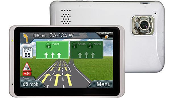
Magellan's new RoadMate GPS stays relevant by including a dash cam
Dedicated GPS units may be less popular these days, but Magellan has figured out a way to justify their existence: strap a dash camera to the back. The company's upcoming RoadMate 6230T-LM DashCam can both guide you through unfamiliar areas and record video to an SD card, saving you the trouble of mounting two devices in your car. Magellan's hybrid design is also handy even if you don't need directions, since you can watch live video from either the built-in camera or an optional wireless backup cam. The new RoadMate won't ship until April, but it will also cost $230 -- a relative bargain next to purpose-built dash cams that offer many of the same features.


