GPS
Latest

Lyft pays $300k to get New York off its back
One downside of reinventing an industry is that you can sometimes forget that the red tape you're bravely circumventing was put in place for a reason. It's a lesson that Lyft has learned the hard way after being fined $300,000 by New York for operating a taxi service without the proper insurance. As far as Attorney General Eric Schneiderman is concerned, ride-sharing outfits are welcome in his state, but only if they're making sure they obey the rules and ensure that their customers are safe.

Uber poaches former Google Maps chief for its self-driving car project
Uber's poached plenty of robotics experts from Carnegie Mellon and now we know who it's snagged to lead that team to produce something worthwhile. According to Re/code, Uber's new Advanced Technologies Center will be led by former Google VP Brian McClendon, a 10-year veteran of the company. The name may not ring a bell, but McClendon is most famous for co-founding the startup that eventually became Google Earth before making Google Maps what it is today.

Future Range Rovers could tell the city about local potholes
Jaguar Land Rover has revealed that it's working on technology that'll alert the authorities whenever your car finds a bump in the road. It's one of several high-tech initiatives the outfit has been working on, including heads-up displays in the windshield and "transparent" cars. Once an issue, like a pothole or broken drain, has been discovered, its location will be uploaded to the authorities who can then send a maintenance crew to come fix it. In the meantime, the information can be shared with nearby vehicles so that motorists in the vicinity can avoid damaging their car.

Philips turns LEDs into an indoor GPS for supermarkets
Philips believes that the days of endlessly roaming around a store looking for the right kind of balsamic vinegar may soon be at an end. The company's lighting division has developed an indoor navigation system that enables your smartphone to direct you straight towards the Oils & Vinegars (Specialist) section. In addition, the technology helps to light everything up nice and bright, and save a bucketload of cash in the process.

Follow the world's mass transit on this live map
Sure, it's not hard to learn when your bus is likely to show up, but have you wondered where everyone else's bus is at any given moment? You now have an easy way to find out. GeOps and the University of Freiburg have rolled out TRAVIC (Transit Visualization Client), a map that shows the real-time positions of buses and trains from more than 200 public transportation systems around the globe. Some of this info is based on schedule estimates, but it's still quite hypnotic -- you can see when subway cars pass by Times Square (hint: often), or how long it takes a bus to arrive at Barcelona's beach. While this tool probably won't be very useful for planning your own trips, it'll definitely remind you just how much effort goes into getting you across the urban landscape.

Apple bought a company focused on super-accurate GPS
Apple has snapped up more than a few companies that know how to deal with your location data, but it now appears to be focused on improving the accuracy of that data from the get-go. MacRumors has discovered evidence that Apple recently acquired Coherent Navigation, a company specializing in very accurate GPS. It combined the usual GPS positioning with information from Iridium's low-orbit communication satellites to pinpoint your whereabouts within inches, rather than feet.

Samsung and Samsonite are working on smart luggage
There have been more than a few efforts at smart luggage, but this is one you're likely going to notice. Samsung and Samsonite (appropriately enough) are teaming up to develop smart bags that will likely be easier to buy and more accessible. They should include include loads of location and mobile notification features, such as GPS tracking, anti-tampering alerts and warnings when you wander away. However, that's just the start. Samsonite is working with airlines on baggage that checks itself in -- drop them off and they'd tell the airport about your airline, the weight and your destination. Also, Samsung is experimenting with self-propelled luggage that follows you around the airport. That last technology is still too cumbersome to be practical (the engine takes up a third of the size), but the days of having to lug (and worry about) your belongings across the airport may soon be over.

DARPA is working on something way better than GPS
When your location marker on Google Maps is pinging all over the place, it's usually due to temperamental GPS signal. DARPA thinks this isn't cutting it anymore, and is developing a "radically" new tech that will offer real-time position tracking -- something that'll work despite blind spots or jamming efforts. DARPA expects this will offer a huge boon to the US Military over, well, everyone else. Beyond war, the new location tech will be good for some much more, and will be far more flexible than GPS. Just like how we now use that once-military network for navigation and location services, new tech is very likely drip down to muggles like us too.

Fitbit Surge review: a top-notch tracker with a flawed design
Confession time: I'm a bit of a wannabe when it comes to self-quantification. The idea of counting every step I take, every calorie I eat, every day I don't have a cigarette and every minute I lie in bed restlessly tossing and turning sounds great. I want to be able to look at my life as a series of easy-to-understand numbers that I can act upon to improve myself. And every time I review a new wearable or fitness tracker I think, "This'll be the one to make it stick." The latest in the long line of would-be life-changers is the $250 Fitbit Surge. The combination of GPS running watch, step counter and sleep tracker appeals not only to the number nerd in me, but also to the semi-serious runner as well. It also appeals to the "someone trying to cut down on the clutter in their life" part of me. Why do I need a separate pedometer, GPS running watch and a regular watch? But the big question is: Can the Surge lock me into not just an ecosystem, but also a system of life-tracking and life-changing habits?

Google knows you stink and wants to help
It takes a special patent to pique our interest these days, but Google has just been issued actual intellectual property for a device that would help others evade your stank. The "odor removing device" (below) is designed to "emit a fragrance in response to detected parameters," but that's not the half of it. It would also detect your body temperature, heartrate and other factors to determine if you're extra rank from working out. Not only will it then dispense perfume to cover it, it'll even track the location of your friends and find you a route home to avoid them.

Get delightfully lost with this route-enhancing motorcycle sat nav
We love a bit of "Choose your own adventure" action, and if a recent Twitter game is anything to go by, so do many of you. The problem with most formats is that they're, well, embedded in a book, or behind a screen. What if you could straddle your Harley, twist the throttle, and go on a real-life adventure? With TomTom's new RIDER bike-centric sat nav, you can. It's actually more about spicing-up an otherwise boring A to B route, than solving The Mystery of Chimney Rock. Or, as TomTom puts it: "bikers can choose the level of twists and turns they want to ride to create their own adrenaline-filled adventure." It does all that other sat nav stuff, too (audio navigation, glove friendly screen, route planning) of course. But hey, now that you can finally afford that Enfield, it's time to soak up whatever those Delaware back roads can throw atcha, right? Adventurers will have to wait until April though, when the RIDER becomes available for an as-yet unspecified price.

Google Maps for iOS gets a welcome update
Google has issued an update to its popular and free Google Maps app for iOS. The update to version 4.2.0 offers filtered restaurant searches that let you specify cuisine type, price and rating, and it gives you weather information from around the world. Another new feature is the ability to drop a pin at your starting and ending points for directions, and you can now add transit directions to your calendar. There are also unspecified 'bug fixes'. Google Maps is still used by a great many iOS users, especially after the sloppy introduction of Apple Maps back in 2012 that even forced Apple CEO Tim Cook to send a letter of apology to iOS customers. Apple Maps has moved forward over the last few years, but it's not likely to top Google in accuracy or depth of information. Google Maps on Android has still more features, including a newly released direction sharing feature which is hopefully headed to iOS soon. Google Maps is a universal app, and it's been optimized for the newest iPhones. It's not a resource hog, and only requires iOS 6 or later.

Epson's first fitness trackers reach the US
After a brief wait, Epson's first batch of fitness trackers is reaching the US. To get things started, it's launching a new golf swing analyzer (the not so elegantly titled M-Tracer MT500GTII, below) that attaches to your club's grip and sends real-time feedback to your phone, ranging from the swing path to the ball impact. It'll arrive in stores in March for $299. The company's Runsense GPS watches are coming along for the ride, although you won't have the option of the basic SF-310 that launched in the UK. Instead, you'll have to consider the stride-tracking SF-510, altitude-aware SF-710 and heart rate monitor-equipped SF-810 (above) when the lineup ships sometime in the second quarter of the year. With prices between $250 and $350, they're squarely in competition with watches from the likes of Garmin and TomTom -- you'll want to comparison shop before you commit to buying sport-minded wristwear.
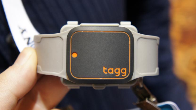
Keep your pets from wandering off with Tagg and Alarm.com
You let the dog out into the garden while you pop back inside to get something. Next thing you know, she's gone. You knew you should have fixed up that gap in the fence. Too bad, huh? With Tagg, no longer would you have the anxiety of losing a pet. This "wearable" for pets claims to be able to locate your pooch (or cat) in almost all of America. How so? Well, there's GPS and connectivity through Verizon. That's how. So, as long as your mutt doesn't stray out of coverage, you'll be able to pinpoint his or her location. But Tagg's not just a one-trick pony/dog/cat. It's partnered with Alarm.com (makers of a full suite of smart home equipment) to add a bunch more functionality, or what the two companies are calling "smart pet tracking."

This pedal tracks both fitness and bike thieves
If bike thievery is an issue in your town, you can ride and rest easy with the Connected Cycle pedal. It has GPRS and GPS built-in to phone home your bike's location whenever it moves, so it can track your fitness, and send a push notification if someone suddenly jumps on your bike. The pedal is a little bulky for cyclists who pride themselves on lightweight bikes, but on the other hand, it never needs charging or a new battery. It charges from the energy of riding, and the team says a one-hour ride is enough to keep it powered for up to a couple of weeks. They've been working on the tech for two years, and plan to release it in a variety of colors with two years of service, for an as-yet unspecified price. In a demo on the show floor everything worked smoothly, with the app easily tracking activity or location. And hey, even if a thief does make off with your bike, you'll have the data to show you still rode a faster split than they did.
Nokia's Here Maps arrives on Android
If you've been looking for a big-name alternative to Google Maps on your Android phone, your moment has come. After weeks of testing, Nokia has officially released Here Maps on Google Play. The experience will be familiar if you sideloaded earlier versions. While it's not as multi-talented as Google Maps, its simple interface specializes in navigation (especially driving) and offline mapping -- this may be ideal for trips abroad where cellular data isn't guaranteed. The biggest additions with the Google Play edition are support for 18 new countries and some bug fixes.

Google asks for donations through charity 'portals' in 'Ingress'
Google's augmented reality exploration game, Ingress, has had a pretty eventful 2014, including an iOS release back in July and the addition of user-created missions a few months later. Now, developer Niantic Labs is closing out the year by getting in the holiday spirit. In a recent blog post, the Ingress team announced its #MissionsForGood campaign, aiming to entice players on both sides of the augmented reality conflict to give back to their respective communities during the holidays. Using the recently added user-created missions feature, verified agents (level 8 and higher) can designate portals at or near local charities and add the #MissionsForGood hashtag in mission titles. The team also added a unique medal for the campaign.

My favorite "on the road" picks
It's another holiday, and for many of us that means driving, gas and food stops, and kids who need to be entertained. I've been thinking about the most useful travel-related apps and hardware I use, so before you head out onto the road, check out my list of favorites and see if any of them can help you during your holiday road trips: Navigation Apple and Google Maps are fine in their place, but if that Thanksgiving dinner is out of cellular range those apps will fall flat. If you want built-in maps with turn-by-turn directions, I've always liked Navigon's iOS apps. The maps are embedded in the apps, so there's no need for a data connection and you won't waste those valuable megabytes of data. There is a large points of interest (POI) database that's well augmented by online info. I also like Navigon's free Scout app, which uses cellular data for the maps. There's a self-contained version of Scout with downloadable maps that is quite good, with a rich database of places to stop for rest or nourishment. That version of Scout requires an in-app purchase, which can be done monthly if you only need it for a specific trip. POI apps If you are happy with your map options, or perhaps have a built-in navigation system in your car, you'll be well served by some of the Points of Interest apps that focus on things that are near you like restaurants, hotels, gas stations and even emergency services. I especially like iExit, which shows you what is located near upcoming highway exits, and Around Me which has similar info. Both apps send locations to your nav app or Apple Maps, and you are on your way. Around Me even supplies gas prices so you can find the best deal for filling your tank. Location Sharing Grandma and Grandpa want to know when you will arrive after your trip "over the river and through the wood". Apple has location sharing built into iOS 8; send a text message and click on 'details' and your location will be updated for anxious relatives. I really like Glympse (free) which is the premier app for letting people know where you are and your ETA. If you send a Glympse, the person you've sent it to can be on any phone with a browser, or even a PC or Mac. Glympse sends a real time moving map, so the relatives can even get an idea of exactly when you're pulling into the driveway. Radar Detectors If you're going to drive for the holidays, you don't want to get a ticket. iRadar from Cobra is a hardware/software combo that lets an app control a full-featured radar detector. The system alerts you if you are speeding, lets you know where the speed traps and cameras are, and lets you report police activity to other users. Other Car Hardware You don't want that iPhone slipping between the seats where you have to scramble for it and create an unsafe situation. There are a variety of hardware options for keeping your iPhone in sight and not flying around in the car. Popular choices are the iOttie One Touch Car Mount ($19.99) and Mpow Grip Pro at $13.99. Odds and Ends Games are great for quieting the kids, and of course that iPad can play recent or favorite movies to keep the kids occupied. I'm sure the kids will have plenty of favorites already loaded onto the iPad, right? That's my little travel bag of tricks. Have a good holiday, and drive safely! Look at the road and not your gadgets.

Smart wallet puts an end to lost cash and dead phones
So long as you still need physical ID cards and cash, you'll need something to carry them -- but that doesn't mean that you're stuck with a low-tech purse or wallet. StreetSmart is crowdfunding the SmartWallet, a money holder with both a Bluetooth-connected GPS locator and a 1,000mAh battery to charge your phone. It's not nearly as world-changing as the company's (rather hyperbolic) promo video suggests, but it's potentially handy if you tend to forget your cash or phone when you head out the door. Leave the wallet behind and you'll get a heads-up through an Android or iOS app that will help you find it, including directions within 50 to 150 feet; lose your phone and a button on the wallet will make your mobile device ring.

MapItOut is a feature rich app for runners, travelers and map mavens
MapItOut (US$1.99) is a very enhanced map program for iOS. You can search almost any city on Earth and then easily find places to go. You save those destinations, and the app creates a customized map for you complete with directions. MapItOut can be used to create a whole travel plan for a trip, or just a local map if you're a runner and want to see the sites while getting your exercise. There are the usual points-of-interest categories, like casinos, museums, coffee shops, beaches, etc, and the app adds a Find My Car feature -- helpful when you're not in your home town and don't know your way around. MapItOut also features a Bluetooth chat function so you can share a trip plan with someone else. Once you have your locations entered, you can easily find things around that location you might not have known about, and the app also searches for flights to a distant location. Once you are set to go, MapItOut opens Apple or Google Maps and provides a summary of travel time. iOS 8 widgets aren't forgotten either: the app will let you set your car location right from the widget pull-down screen. I tried MapItOut on a few destinations and found it easy to use, even though it is loaded with features. It takes a very unique approach to setting up trips and destinations, and I think some other apps could learn from the approach taken here. MapItOut supports driving, walking, cycling and hiking, and I think MapItOut is well worth the money. The only issue I saw during testing was that it was sometimes very slow in drawing the location maps, even on WiFi. On a couple of occasions, the app did not generate a weather report, although that is an embedded feature. MapItOut requires iOS 8.1 or greater. It supports many languages, so it's really ready for travel anywhere. The app has had some updates since launch, and I expect it will get more.


