GPS
Latest

Old-school seafaring tech repurposed as a GPS fallback
GPS is super useful when you're trying to navigate unfamiliar areas in cars and on foot, but for ships, it's an outright lifeline. Many vital systems, especially on large commercial vessels, rely almost entirely on GPS data, meaning it's a pretty huge deal when satellite connection is lost. GPS is far from infallible, and signals can be jammed by equipment and even solar storms, which is why the UK has begun rolling out a fallback positioning network that uses technology first implemented by the US Navy during WWII. The once-popular Loran positioning system was essentially superseded by GPS, but in a twist to the tale, the UK is using an improved version, known as eLoran, to ensure ships aren't completely reliant on satellite signals. Trials started at the beginning of last year, and the first seven eLoran stations are now live along the East coast of Great Britain, with all the UK's major ports expected to be covered by 2019.

Android Wear's latest update adds GPS support and offline music playback
Android Wear, Google's four-month-old wearables platform, is off to a good start. But like all nascent systems, there are still plenty of areas that need some TLC. It's got a lot of features and developer support, but it's practically useless if you want to use your smartwatch as a fitness tracker and leave your phone at home. Over the next few days, Google will push a new update to the LG G Watch, Moto 360 and Samsung Gear Live that will make your smart timepiece more useful when it's not tethered to your handset.

Apple launches Maps Connect to let businesses add details to their Maps listing
Apple Maps has experienced some growing pains over the years, but with time the app has become a useful GPS solution. Of course there's always room for improvement, which is why Apple has launched Maps Connect. Maps Connect is a new service for small business owners who want to add more information to their Apple Maps listings, or change details that are out of date. Users can login to the site using their Apple ID and update or change their business's information for free. You can include your business' address, hours of operation, links to your social media pages, and even your Yelp page. Once you update your information a verification code is sent via telephone. A source at Apple has told Search Engine Land businesses would also be able to verify their information using an email connected to their business website in the future. Their source also said that updates and new listings could take up to a week to show up on the service. Apple is also using the service to promote their iBeacon technology. When you login to the service you'll see a drop down menu in the upper left side of the screen. This allows you to specify if your business is indoor or a store front. If you select "Indoor" it shows you the following screen. Apple is prioritizing access to the service to larger venues currently. Here's what the sign up process looks like. You can sign your business up right now by heading over to MapsConnect.Apple.com.

Bluesmart wants to crowdfund the 'world's first' connected luggage
Losing your luggage is no fun, but while companies like Trakdot have been selling trackers for some time, a startup is taking to Indiegogo to create what it calls the "world's first smart, connected carry-on." Bluesmart is a small suitcase with a host of features that its makers believe frequent travelers can't live without. Priced at $235 (or as low as $195 for early adopters), it'll include proximity tracking to alert you if you walk away from your luggage, a TSA-approved lock that's controlled by your smartphone and a built-in battery to charge your gadgets. There's also a scale integrated into the handle that'll tell you how much your bag weighs just by lifting it off the ground, and a quick-access compartment for storing your laptop.

Fitbit's new wearable looks like a watch, crams in GPS and a heart rate monitor
It's been a while since we've seen a new Fitbit product, but according to a leak obtained at The Verge, that's because the company's been working on something a little special. The Fitbit Surge is a "fitness superwatch" that houses two must-haves for serious running types: GPS tracking and a heart-rate monitor. Crucially this would mean the wearable can monitor your activity without having to haul around your smartphone. (The likes of the Galaxy Note 4 or iPhone 6 Plus aren't all that well-suited to a jog in the park). The leaked marketing materials also suggest it will priced at $249 and will still be able to monitor all the less intense calorie burning done on stairs and your commute to work. Borrowing from the smartwatch category, the Surge is also promising smart notifications for calls and texts, as well as music controls. According to The Verge, the watch is rumored to launch in three colors (black, slate and tangerine) in the next few weeks, likely alongside the pair of more lightweight Charge fitness trackers - also leaked in marketing materials. C'mon guys, tighten up that security. We've reached out to Fitbit for more.

Garmin's multi-sport GPS watch now talks to your phone
Garmin's GPS watch lineup has had an imbalance as of late; while more modest athletes have had luxuries like color displays and phone integration, you've had to make do with monochrome and old-school PC syncing if you need multi-sport wristwear like the Forerunner 910XT. Thankfully, you won't have to make that sacrifice any more now that the company has launched a much-needed follow-up -- not surprisingly, the Forerunner 920XT. The new watch tracks your biking, running and swimming stats like its ancestor, but catches up on 2014-era tech through a color screen, phone support (including call and message notifications) and advanced data like your running gait and oxygen volume estimates. It should be lighter, thinner and more comfortable than the 910XT, too, so you won't notice it quite so much while you're in the middle of a practice session. Just be ready to pay up if you want Garmin's most capable wearable. The 920XT starts at $450 ($50 more than the 910XT) all by itself, and you're looking at $500 if you want a heart rate monitor at the same time.

For drivers with bad credit, new cars come with a kill switch
Driving a car off a lot usually comes with a sense of exhilaration or freedom, but that thrill is short-lived when you've got a debt collector riding shotgun wherever you go. That's basically the case for a whole host of Americans with bad credit -- in use since the 90s, the New York Times reports that now some 2 million cars in the United States are outfitted with remote kill switches that shut cars down if their owners fall behind on payments. The system is simple enough: once installed, the so-called starter interrupt will sit in place and beep to notify drivers that their payments are coming up. Once delinquent drivers tiptoe past a certain threshold (which seems to vary by lender and state), some account manager somewhere hits a button and voilà -- that motor won't purr until someone pays.

Android Wear updates will let you leave your phone at home
One of the biggest gripes of smartwatch ownership is the (usual) dependency on your smartphone; do you really want to carry two devices when you're going out for a run? If you're an Android Wear fan, you won't have to in the near future. Google tells CNET that "several" updates are coming to its wearable platform before the end of the year, some of which will let you cut the figurative cord. Bluetooth headset support will let you put some music on the watch to listen at any time. GPS support will let you map your run while leaving your phone at home, although you'll logically need a watch with position tracking built-in -- in other words, don't expect it to show up on your early G Watch or Gear Live.

Epson dives into fitness wearables with heart and run trackers
How do you know when wrist-worn technology is officially a trend? When a brand best known for its printers gets in on the action. As promised, Epson is launching its first wrist-based wearables, and they're all about improving your fitness. Each line delivers a slight twist on a familiar formula. The Runsense GPS watch range (shown above) can track your running even if it loses signal thanks to stride sensors on some models, and lasts for a healthy 30 hours of continuous tracking; you may not need to recharge for days. The Pulsense line, meanwhile, monitors your heart rate, activity and sleep quality using a blend of optical and motion sensors. You theoretically never have to take the tracker off, although the 36-hour battery suggests you'll be doing that quite often.
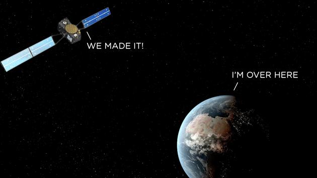
Europe launches two navigation satellites into the wrong orbit
Arianespace, the company that launches satellites for the European Union, has had to concede that its latest mission hasn't been a complete success. Friday's launch conveyed two satellites, Dorea and Milena, into orbit to help build out Galileo, the EU's homegrown alternative to GPS and GLONASS. Everything had gone to plan when the Soyuz rocket reached the upper atmosphere and deployed the satellites, but shortly after, authorities realized that the units were in "noncompliant orbit," which means they're spinning around the planet in the wrong orbit.

Your iPhone could help you find where you parked your car
Two freshly published Apple patents might make your next visit to the mall a bit less stressful. "Automatic Identification of Vehicle Location" and "Vehicle Location In Weak Signal Scenarios" -- which were both filed in early 2013 and became public today -- describe systems that can point you to your parking space with or without the assistance of GPS. Far from a simple waypoint system that sends you back the way you came, both patents note that the system "can determine when a vehicle in which the mobile device is located has entered a parked state," automatically. This can be achieved either by utilizing an iPhone's built-in accelerometer to determine the difference between in-motion driving and a stopped, parked state, or via a data connection with the vehicle itself, which would then tell the device that the car is indeed parked. Once this is determined, the user's path away from the vehicle is tracked to allow for the return trip to be plotted. As someone who hates going to the grocery store for multiple reasons -- one of which being that I never remember to mentally note my parking space -- this could certainly come in handy. As with all patents, however, we may very well never see this system make it into a device, though it certainly seems to be technically doable with existing technology. [via AppleInsider]
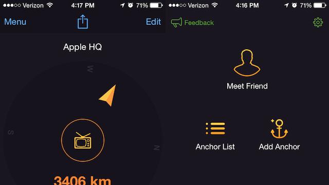
Anchor Pointer is a great app for finding your car or that great fishing spot
One of the downsides of using geolocation pins with standard GPS apps is that they're designed with driving and roads in mind. For those of us who walk more than we drive, these routes aren't always ideal. After all, your feet aren't confined to streets and the fastest route between two points is still a straight line. That's why I've enjoyed using Anchor Pointer as my go-to navigation tool when I'm trying to find my way back to locations I've discovered while walking around or when I'm trying to find where I parked my car. Anchor Pointer gives you a compass that directs you to locations you've already been to. It's designed for saving locations rather than finding them via discovery, which makes it ideal for hikers and urban explorers, or just to find your car at the mall. The way it works is simple: when you find a location you want to save you, tap "Add Anchor" to save the location. You can add an icon and a name to represent the location. If you're just looking to save the location of your car in a parking lot, that functionality is listed on the main app screen as "Park Car." Once you select a location, Anchor Pointer provides a compass that directs you back to where you once where. It doesn't matter if you've never used a compass before -- simply follow the arrow and you'll find your way back. The parking feature has proven indispensable when looking for my vehicle in parts of town I might not already be familiar with and in large mall parking lots. However, the real charm of Anchor Pointer ls as a way to rediscover places you've been to once and want to revisit. Find a cool coffee shop while walking around your neighborhood? Drop an anchor. Discover a mural on the side of the road you want to remember? Drop an anchor. Maybe you're a fisherman and you've found an ideal spot where they're always biting. No problem, you can even drop an anchor over water and have the compass navigate you back to that spot. Anchor Pointer also has a "Meet Friend" feature allowing friends to share their location with you. I haven't been able to use this feature yet as no friends of mine use the app, but given how well everything else works, the tool could be very useful for meeting up with friends in the park or at a concert. I could see this feature being very attractive for parents trying to meet up with their kids at a crowded location. Anchor Pointer includes a handy automatic Night Mode that adjusts the brightness of the app based on the time of day, making it ideal for using at night in the woods without suddenly being blinded by your phone. You can also turn off the auto brightness function if you wish. Whether you're an adventurer looking to find your way back to your discoveries or just someone who is sick of losing your car in mall parking lots, Anchor Pointer is a delightfully useful app. My only complaint is that you currently can't drop an anchor unless you're physically at a location. It would be nice to use the handy compass feature to find my way to a place I know the address or coordinates of, even if I haven't already been there. Hopefully that shortcoming will be fixed in a future update. Even without that ability, Anchor Point is a handy tool for adventures and travelers. Currently the app is only $1.99 in the iTunes Store. That's a small price to pay for such a useful exploration tool.

Solid's vibrating handlebars navigate bike lanes on its 3D printed frame
Just like when you're driving a car, glancing down at your phone while biking the busy streets of your city can be quite dangerous. Thanks to a Portland-based design firm, there's a bike that allows you to keep your eyes on the road while getting those much-needed directions. The folks at Industry teamed up with local builders Ti Cycles for Solid: a Bluetooth-enabled two-wheeler that connects to a smartphone app monitoring bike maintenance and offers vibrating handlebars for head's up GPS navigation. A companion app, My Bike, keeps an eye on burned out lights and other potential upkeep headaches. My City, a second bit of software, serves as guide for blazing the bike lanes of your chosen locale.

Yahoo researchers teach GPS to take the scenic route
Often the shortest route between two places involves some grey, eight-lane expanse of Interstate that's about as thrilling to drive as it was to pave. Resourceful road-trippers have learned to make use of the avoid highways feature, but that's always a crapshoot. Sometimes you get a scenic country road, sometimes you get trapped in strip mall hell. But researchers at Yahoo Labs have figured out how to measure the "beauty" of a route using an algorithm. "The goal of this work is to automatically suggest routes that are not only short but also emotionally pleasant," which might be especially important to pedestrians looking to avoid grim over passes and busy intersections. The work started by crowdsourcing opinions about images harvested from Street View and Geograph for locations throughout London. The locations that were deemed to be more beautiful by users were then plotted on a map and used as waypoints to provide directions. The resulting routes were on average only 12 percent longer than the shortest path to a destination, but 30 test subject all agreed the results were more pleasing, aesthetically.

Group GPS is a great app for hikers, bikers, and those wanting to stay in touch
Group GPS (free) is one of those "Gee, I wish I had thought of this" apps. To get started, you sign up for a free account by supplying a user name and an email address. Create an activity, like 'bike race' or 'desert hike,' and send an invitation to your friends. If they don't have Group GPS, they get a text message with a download link. When everyone responds, you'll see each person identified on a map, and their movements update as they move around. I can think of lots of applications, like meeting friends at a location and seeing that they are on the way, finding people at a concert, car rallies, almost anything. When the activity is done, just stop Group GPS and you're removed from the activity. You can also pause the app anytime and return. The map can be zoomed in for more detail on a single position, or zoomed out to see everyone else's location. The Group GPS account was easy to sign up for. It doesn't matter where the other people are; even if they are in another state, you'll see the map stitch to fit everyone, and you can watch your group converge. Apps like Glympse are perfect for letting people know where you are and your ETA. Group GPS lets everyone in a group know where everyone else is. In testing the app, I noted that the position updates aren't in real time, more like once a minute or so. This was likely done by the developer to preserve battery life, although I'd like to see an option to step up the update frequency. The app is ad-supported, but the ads are not invasive or distracting. Having said that, I'd be glad to see a paid version with no ads and a few new features, like being able to message the group from within the app. If you'd like to see the app in action, you can check out a video on the developer website. A similar free app is FastWhere, which also does location sharing. Group GPS is a really great idea, and I think most people will find some good uses for it. The app requires iOS 7.1 or later. It's not universal, but it is optimized for the iPhone 5.

Test driving the new Garmin viago navigation app
Garmin launched its new navigation app viago on Tuesday, and I promised to give it a try and review it for you. Garmin provided me the complete kit, so I could install built-in maps, enhanced 3D graphics, and speed and camera traps. It also included urban guidance, which lets you navigate on foot or by public transportation. Installing everything takes some iPhone space, a bit over 2 GB on my iPhone 5s. It was a s l o w download, likely because there were a lot of people installing viago at the same time. I downloaded the North America map set, which includes all 50 states, and some smaller locations like the Cayman Islands. Compared to other Garmin and Navigon products that have the same heritage, viago is easier to use with a very clean interface. There are fewer nested menus, so getting up and running is quick and easy. You choose a route by tapping on 'Where to?'. You can enter an address, the name of a city, an intersection, a POI, do a local search, or even enter latitude and longitude. It's also possible to use an address from your contacts, or look at previous destinations or favorites you designate. From there you select your mode of transportation (public, car or walking) and you are on your way. Before you actually start navigating, viago will provide a phone number for your destination if available, and even a weather forecast for that location. The navigation screen is very nicely laid out, and settings allow you to decide what info is displayed, even your altitude, ETA, how many hours or minutes until your arrival, and more. Selecting a theme for the app varies the colors of the base map and the menus. My package also gave me my speed and the posted speed limit. Viago can be set to sound an alarm if you exceed the speed limit. While you are in the navigation view, touch a button to get a route overview and a list of all the turns you will make. The navigation voice is very clear, and this app does something Apple Maps doesn't do -- when paired with my car via Bluetooth, viago interrupts the radio or music playback to announce turns. It's really nice, and more closely mimics what a built-in system would do. Although not needed for navigation, I liked the Panorama 3D view, which shows elevation cues and mountains with shadows. The buidlings option displays major landmarks in a 3D view, which can be helpful when navigating an urban landscape. The app was quick, and turn information was provided in a timely fashion so it gave me enough time to get into the correct lane. My version was also equipped with lane assistance, providing a diagram of what lane I needed to be in to negotiate a turn. The POI (points of interest) list was quite complete, allowing me to find places by category like seafood restaurants, pharmacies, ATMs, lodging, etc... To test how dependent viago is on a data connection, I put my phone in airplane mode and launched the app. The POI database functioned, and it was able to calculate a route. That's positive. Some functions, like weather forecasts, won't show up without the data connection. If you load up viago with everything you can buy, it totals about $75. That seems pretty pricy, but it is lower than adding similar features to the current Garmin and Navigon apps. For example Garmin USA starts at $50.00, then you add traffic for $20, Panorama view for $10.00, Urban Guiadance for $5.00 and Traffic Cameras for $6.00. That totals $91.00, and it still doesn't have some of the features viago offers. Navigon USA is similarly priced, as are other apps that feature complete on-board maps. You don't have to buy everything, so you can lower the price further by dropping non-essentials like Panorama 3D. Of course Apple Maps, Google Maps and Google owned Waze are free. Both Google and Apple allow some caching of maps for offline use, but having all the map data on-board is far better when you are watching your data charges or driving in an area with no cellular coverage. Apple has seamless integration with Siri, which is really helpful, plus the Flyover mode which gives 3D photographic views in larger cities. Here's my view of the good and the bad of viago: Pros: Basic version is inexpensive -- just $0.99 on sale -- but limited in functionality Clean screens Fast performance Good POI information Can customize app to match your needs Cons: Expensive with options, some of which you will want No voice interface, unlike Apple, Google and Telenav Scout No social ETA system, like Glympse, which Navigon and Garmin offer in their other products . Waze offers this for free No ratings for retailers and restaurants. Apple offers Yelp, as do some of the other navigation providers. Navigon offers Zagat ratings in some of their other navigation apps as an additional purchase What's in the $0.99 version (that price doubles July 13) Maps that require a data connection Cuurent speed and speed limit display Lane Guidance photo real junction views Route planning Traffic in-map info Weather at destination 2D and 3D navigation Summing up: I like viago. It's very well thought out, attractive, efficient on screen, and you won't need a manual. I like the integration of traffic, speed warnings, 3D buildings and the panorama view, but those features all cost extra money. The free version of viago has to download maps over the air just like Google and Apple, but some users may prefer the GUI. I do think viago has the potential to be much better than the current Garmin/Navigon offerings, but it doesn't have complete feature parity yet. viago has some things the other offerings don't, but is missing nice touches like voice interaction and Glympse, although Garmin hints that they are looking closely at these features. viago is not a universal app, so bad news for iPad users. It requires iOS 7 or greater.

Daily App: Garmin víago - a new navigation app for iOS
With all the great navigation apps that are available for free, developers with paid apps must be creative to attract customers. Today, Garmin upped the ante with new navigation app called víago for US$0.99 (with in-app purchases that are on sale until July 13, 2014). Garmin víago offers advanced navigation features not available from free apps, guiding drivers through the most challenging situations with ease. The app comes with off-board maps for many regions around the world and navigation features like current speed and speed limit display, lane assist, weather information, in-map traffic display, and photo-realistic junction views. Users can easily upgrade their experience with premium add-ons like downloadable maps ("Maps to Go") that don't require a data connection to navigate, real-time traffic with automatic rerouting, urban navigation with public transportation, 3D terrain view, and much more. víago also is the first smartphone navigation app that features Garmin Real DirectionsTM (available via in-app purchase), giving spoken, turn-by-turn directions that utilize recognizable landmarks, buildings, stop signs and traffic lights. The new app also runs with the Garmin HUD, a hardware heads-up-display that projects turn information, distance and other information onto on your car's windshield. The app is inexpensive to get started, but it is pretty bare bones. Once you load it up with in-app purchases that range from $4.99 to $19.99 each, you are going to be in the same ballpark money-wise as the other Garmin/Navigon family of apps. The company says that, with this approach, customers can choose just the features they want. víago looks like an impressive app, and I will be anxious to test it over the next few days. Features like urban guidance with transit information, extensive weather information for your route, and more intuitive directions sounds like the app could be a winner. With maps on board, you can avoid the data charges that can come with using constantly downloading maps from some of the other apps being offered. Garmin víago is available for US$0.99, with in-app purchases on sale until July 13. After that, the basic app and several in-app purchases will double in price. The app is not universal, it's designed for the iPhone, and it requires iOS 7 or later.

Garmin's new app lowers the price of premium navigation
While Garmin is no stranger to mobile navigation apps, it has continued charging $30 or more for its StreetPilot software even after breaking out some components as in-app purchases. That's a hard bargain in an era when phones offer GPS tricks like lane assistance for free. Clearly, the company is aware of this discrepancy -- it just unveiled Viago, an app for Android and iPhones that tries to bridge the pricing gap. Fork over $2 ($1 until July 13th) and you'll get worldwide maps alongside lane assistance, realistic junction views, speed limits, weather and traffic. You only pay more for the features you want, and some of them are unique -- Real Directions gives you directions based on landmarks rather than street names, while Active Lane Guidance simplifies taking that next off-ramp.

US government wants tighter controls for in-car navigation
Many are in favor of rules that prevent texting while driving, but in-car navigation is a murkier legal area -- how do you minimize distractions without limiting the ability to get from point A to point B? Like it or not, the US government may settle that debate before long. The proposed Grow America Act would let the National Highway Traffic Safety Administration (NHTSA) set rules for dash-mounted GPS units, smartphone mapping apps and anything else you'd use for driving directions. While it's not clear what the NHTSA would do with its power, the Department of Transportation's voluntary guidelines ask for limits on eye-catching visuals (think videos) and interaction times; don't be surprised if these enter the rulebooks.

Meet Skylock, the smart bike lock that can save you after a crash
There are plenty of smart bike locks that warn you about thieves, and some will even let you share your bike if you're the generous sort. However, their utility often stops when you start riding -- which is where Velo Labs' new Skylock comes in. The security system compares its own motion sensor data with that of your smartphone to tell if you've been in an accident. If you tumble off and don't respond within a set time frame, Skylock will alert emergency services that you're in trouble.


