Maps
Latest

Google Maps now offers easy access to important info
Google Maps' Marcus Lowe has announced a tweak to the service that makes it significantly more useful for Android users. Nestled at the bottom of the home screen will be a new section containing real-time information for busy travelers. Simply swipe up and you'll be presented with three tabs offering data that'll ensure you never need to consult a third-party app again. At least, that's Google's plan.

Google Maps warns you about parking woes before you leave
A parking difficulty icon popped up in an Android beta for Google Maps earlier this month, but now the feature is officially rolling out. However, there are a couple of caveats. First, the parking warnings are only available in the Android version of Google Maps for now. The new tool will also only warn you about potential parking headaches in 25 US metro areas.

New 'Overwatch' map lets you play in traffic
Overwatch's Winter Wonderland event may be over, but Blizzard has one more present in store for players: a new map. Blizzard's been teasing the new control point map for a few months now, promising a new control point map with new environmental hazards and traversal options. Indeed, that's all here -- Oasis features jump pads that launch players high in the air and an active highway filled with deadly traffic. And yes, getting in the way of a car is a one-hit kill.

Here Maps is expanding to China with the help of new investors
Here, the mapping company owned by German automakers Audi, BMW and Daimler, plans to bring its products and services to China. To make that happen, it has enlisted the help of three new Asian investors: Chinese internet giant Tencent, digital map provider NavInfo and Singaporean investment firm GIC. They're acquiring a 10 percent stake in Here together, and they're tweaking the company's products to make them ready for the Chinese market.

Facebook won't flag your friends on a map anymore
Facebook is making some significant changes to its Nearby Friends feature that lets you see where pals are, Techcrunch has noticed. Most significantly, it has eliminated the precise tracking feature that tells you exactly where friends are by pinpointing them on a map. Now, you can only see them in a list along with an approximate distance away. While the original feature made it easy to check someone's progress or tell you when they arrive, for instance, it's also a bit of a privacy nightmare if you forget to turn it off.

Apple is reportedly using drones to improve Maps
Apple is putting a team together that will capture mapping data using drones to supplement its camera-equipped minivans, Bloomberg says. While its Maps app is no longer the butt of jokes, Apple reportedly wants to better the quality of Google Maps, an app that's still more widely used on all platforms. The team may use UAVs from companies like DJI and Aibotix to keep maps up-to-date with construction, new roads and other info.

Google timelapses offer a 32-year look at Earth's history
As static as it may seem, Earth is a lively planet that changes almost constantly -- and Google just offered a clever way to see that development with your own eyes. In a partnership with Time, it's introducing a dramatically improved version of Google Earth Timelapse that provides animated satellite imagery covering 32 years, going back to 1984 (4 years earlier than before). It uses the higher-resolution maps you saw in June to provide a look that's both more detailed and more seamless than before, with fewer abrupt changes in color and quality. There's also more to look at in the first place thanks to both added legacy satellite data and info from newer orbiters.

Google Maps will help you avoid Black Friday hordes
For over a year now, Google Maps and Search have been telling people when stores, bars and restaurants are likely to be busy. Now, it's going one step further. From today, searching for a business via Google will not only show you when it's typically crowded, but also an estimation of how busy it is right now. So if you see that a particular store is very full you can plan to head somewhere else. It's hoped that the feature will help users avoid the worst of the crowds over Thanksgiving long weekend, and beyond. There are a couple of other additions rolling out today. Place listings in Search and Maps will now tell you how long the typical stay is at a location, so if you people usually spend two hours at a restaurant, you can plan the rest of your day accordingly. Finally, Maps will now list more complex opening hours. "You'll know what time to pop by the pharmacy at your local drugstore or supermarket, when food delivery begins at a nearby restaurant and what the service hours are at the auto dealership," said Google.

This is how the world looks on Facebook's population maps
Facebook's Connectivity Lab today released its high-resolution population maps for Malawi, South Africa, Ghana, Haiti and Sri Lanka, with the promise to make more datasets available over the coming months. The population maps are a joint effort between the Facebook Connectivity Lab, Columbia University and the World Bank, though Facebook is interested in the project as part of its effort to launch wireless communication services in rural regions around the globe.

Conjure spells on your phone to prepare for 'Fantastic Beasts'
J.K. Rowling's prequel to the Harry Potter series is set to hit theaters next week and Google wants to help you prepare by turning your phone into a magic wand. On an Android device, you can cast "spells" with an "OK Google" voice command. After you alert your phone with the magic phrase, follow it up with a command like "lumos" and "nox" to turn the flashlight on and off. You can also use "silencio" to mute any sounds and notifications. Sure, it's rather simple, but it's a neat way for Potter fans to get ready for Fantastic Beasts and Where to Find Them ahead of next week's debut.
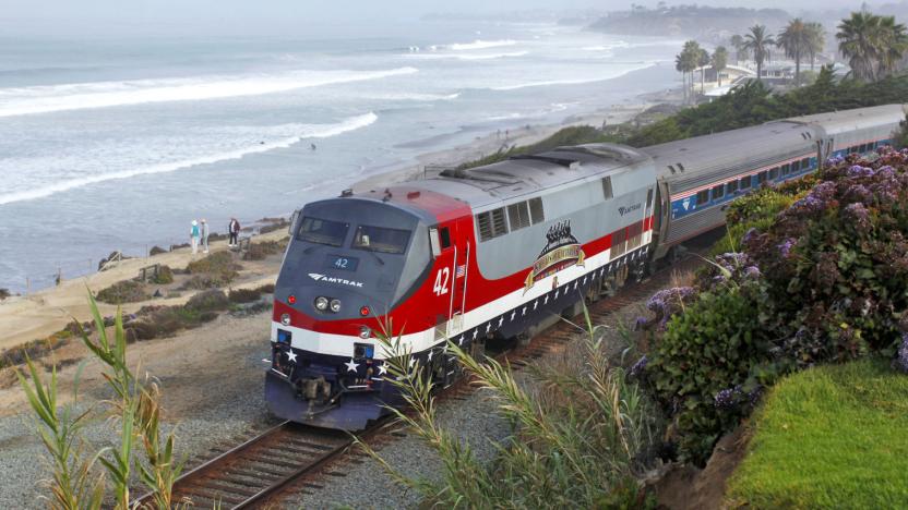
Apple Maps displays nationwide Amtrak train routes
Prefer to travel cross-country by rail? If you're an iPhone owner, you no longer need to fire up a third-party app to plan your trip. Apple Maps has introduced support for Amtrak train routes across North America -- if you want to navigate all the way from Los Angeles to Toronto while seeing the sights, you can make it happen. You'll need to live in an area where Apple's mass transit directions are available, of course, but this remains a big deal if you're more interested in how you travel than the time it takes.
Google Maps will show where your next Calendar appointment is
Google has been all about change for its suite of productivity apps this week, and now we're seeing what happens when some of the disparate services combine. On Android, Maps and Calendar are joining forces to give a quick visual reference for where your various appointments will take place. You need to be signed into both apps with the same account, of course, but other than that it all seems pretty easy to set up and use. Just put the event's address in the "where" box when creating a Calendar entry and you should be good to go according to Google's Keyword blog. Maps information has cross-pollinated into Calendar previously, so it's pretty cool to see this go the other way, too.

Hands-free 'Ok Google' commands come to Google Maps
The "Ok Google" command has expanded since the debut of Android KitKat, allowing devices to respond in various smart ways to those two words. Now, Google Maps on Android has this ability too, whether you're in the middle of a road trip or doing something else. Once it's enabled in settings, you can choose whether it works only while Maps is open or from any screen. Say the magic phrase then follow it up with something like "find a gas station" or "How's traffic ahead?" and it will let you know.

Windows 10 Maps will show the traffic on your route home
Fans of the Maps app on Windows 10 will have something to look forward to with its latest update. Now, you can see what the roads are like either to home or work (or whatever locations you've labeled as such) and even take a gander at realtime traffic from recently viewed roadside cameras. Just hit the traffic icon from the app's menu, according to the Windows 10 blog, and you're there. What's more, the app will follow your preferences for a night or day mode within the app and apparently change themes wholesale. Sure, Google Maps has had most of these features for a bit, but it's good to see that the Windows faithful have a few new toys to play around with.

Google's latest acquisition should make Maps a bit better
Urban Engines has been analyzing city traffic and how people get around. So, naturally, it'd make sense if the company was acquired by an outfit interested in making its maps more efficient. That's where Google comes in. The search giant has bought the Urban Engines with the sole purpose of improving Maps. "Location analytics is an important focus for both Urban Engines and Google, and we're excited to combine forces to help organizations better understand how the world moves," the announcement post reads. It's a little early to tell exactly what Urban Engines will bring to the table for Maps, but based on its history, perhaps better routing around traffic jams is a pretty safe bet.

Instagram is dropping photo maps
Instagram isn't just piling on new features -- it's taking them away, too. The social image service says that it's removing the Photo Map feature, which lets you see where a person's snapshots come from. The removals started last week, Instagram adds. It's currently focused on removing maps on profiles of other people, but you'll eventually lose access to your own photo map as well. Location info will stick around (such as pages showing all the photos taken at a given place), however, so you won't lose track of where you took that stunning flower shot.

Scientists finally made a half-way decent map of Alaska
To protect the Arctic from climate change, scientists require a detailed map which they can slowly update and reference over time. Such a resource has, until now, been difficult to produce because traditional capture methods -- low-flying aircraft, for instance -- are expensive or ill-equipped to deal with the region's harsh weather patterns. That's now changed, however, thanks to a project spearheaded by the National Geospatial-Intelligence Agency (NGA) and the National Science Foundation. Following a directive from President Obama, the group has captured Alaska with a new level of clarity, using commercial satellites owned by Digital Globe.

Google expands 'Sheep View' project with Trekker cameras
Without the presence of Google, Faroe Island residents had to rely on camera-equipped sheep to provide 360 degree "Sheep View" images of the bucolic isle. While that's adorable, digital tourists probably want to see more than just areas with the most delicious grass. Luckily, Google heard about their plight, and decided to give the burdened quadrupeds a hand with its Street View camera loan program.

Google adds even more 3D Touch support to its iOS app
The Google app on iOS has supported 3D Touch for awhile, but that's going, ahem, deeper. Now you can deep press on the big G at the bottom of the screen to start a new search query from anywhere within the app. Doing the same on Search and Maps results will offer previews of web pages and maps, respectively, while an even firmer press will open the links or Map. If you don't have an iOS device that supports the feature, long pressing will net you the same results. Beyond that, version 18's patch notes are barren aside from word that there are more Doodles and games coming in the future.

Waze will help you avoid traffic jams around big events
Navigation apps like Apple Maps, Google Maps and Waze are good for letting you know when you're approaching a traffic jam. Waze is taking that task a bit further with its new Global Event Partner Program. The company is teaming up with organizers of big events like marathons and pro sports to keep you from experiencing unnecessary delays. Those partners will now be able to use the Waze Closure tool to input any scheduled closures ahead of an event. TechCrunch reports that event organizers will be able to add details like turn restrictions, lane reversals, parking locations for more than 65 million users.


