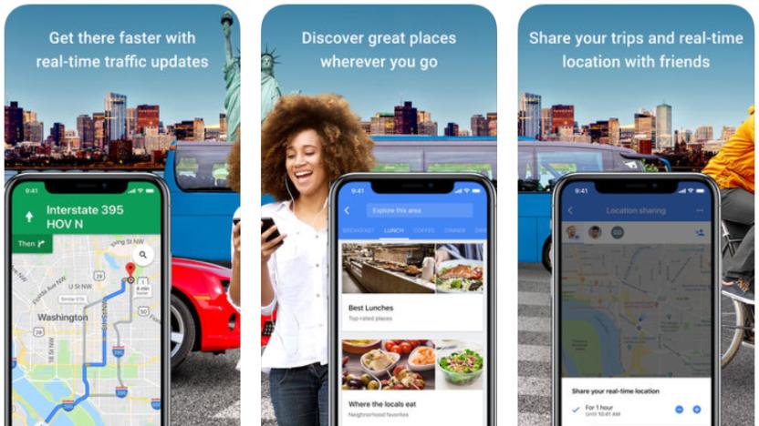
Maps
Latest

Google Maps gets collision and speed trap reports in latest test
When Google bought Waze back in 2013 it was widely assumed it would only be a matter of time before some of the traffic app's more popular features made their way onto Maps. It's taken a while, but now it looks like Google is getting ready to add incident reports -- a move suggested by an APK teardown a few months back and, more recently, the appearance of the feature for some Maps users.
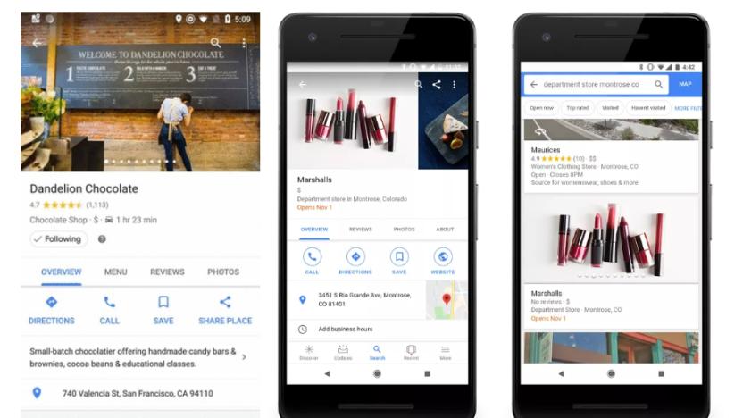
Google Maps' 'Follow' button gives you updates from real places
Google has launched a number of new features for Maps over the last few months. Now, it's rolling out a "Follow" function for locations, which will give you updates on events and offers from your favorite stores and restaurants. And it'll tell you about new places that are opening soon. In search results, dates will appear in bold, and the store card will be populated with its forthcoming address and website.
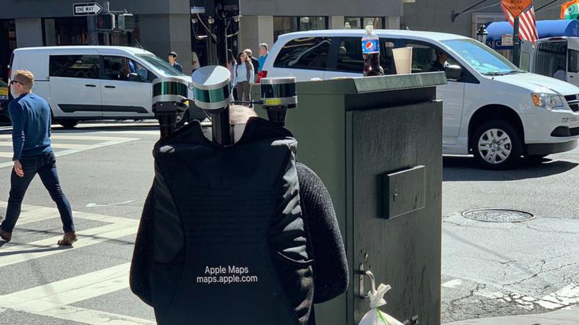
Apple is using backpacks to collect map data in San Francisco
Apple's quest to improve Maps' accuracy appears to include some on-foot action. Former Engadget writer Dante Cesa has posted photos of an Apple Maps worker carrying a backpack loaded with cameras, LiDAR sensors and other equipment as he walked through San Francisco. It's not certain what the exact goal was, but MacRumors speculated that he was collecting details for pedestrian directions.

Google Maps works with Apple CarPlay following iOS 12 update
We've known since WWDC in June that iOS 12 would herald the arrival of Google Maps on CarPlay. Apple released the latest version of the iPhone and iPad software Monday, and after Google updated its app to support CarPlay, you can now use that navigation option on your car's infotainment system.

Recommended Reading: Fixing Apple Maps
Apple is rebuilding Maps from the ground up Matthew Panzarino, TechCrunch It's no secret that Apple Maps has lagged behind other options like Google Maps and Waze, but that may not be the case for much longer. TechCrunch has details on how Eddy Cue and his team are giving the app a complete overhaul -- one that begins with the company using its own map data.

Apple is fixing Maps using its own data
Apple Maps has come a long way since the fiasco when it first launched, but there's no question that there's room for improvement. It just isn't as robust as Google Maps, which has the luxury of both a years-long head start and complete control over the mapping process. And Apple knows it. In an interview with TechCrunch, the company's Eddy Cue has revealed plans to revamp Maps using its own data set rather than the current piecemeal approach, which has relied on info from the likes of OpenStreetMap and TomTom. The new technique promises not only greater mp accuracy and detail, but faster updates that take days rather than months.
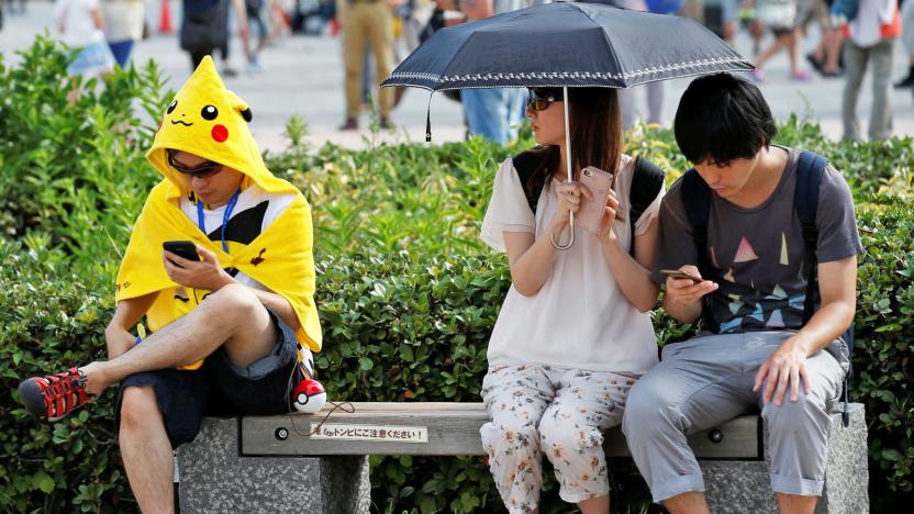
Niantic is building AR maps with help from 'Pokémon Go' players
Niantic may have split from Google years ago, but there's a little bit of Google culture left -- namely, the Maps part. The developer told Reuters that it's planning to create 3D augmented reality maps with the help of Pokémon Go players' cameras. Gamers would help map public spaces (such as parks and plazas) so that the AR experience could extend to the entire environment, not just characters. And crucially, these wouldn't be limited to Niantic's own games -- the company hopes to offer these AR maps to third-party developers.
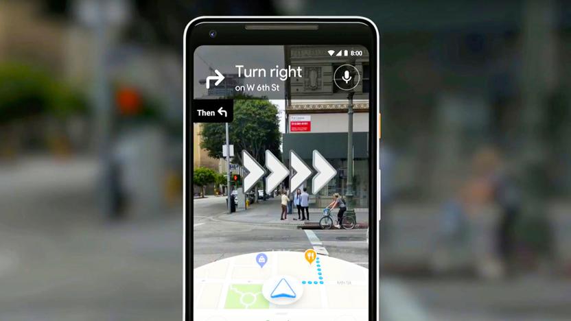
Google shows off its camera-enabled navigation system
Google knows the problems you have to deal with when navigating an unfamiliar locale, even if you do have your smartphone on you. That's why the company's Aparna Chennapragada is showing off an updated version of its VPS, or Visual Positioning System: A way for folks to avoid getting lost when out and about. Rather than craning over your phone and hoping you're walking in the same direction as the blue GPS dot, the camera can look at your surroundings and work it out for you.

Google uses its search skills to help fight opioid addiction
Google is using its influence as a search giant to fight opioid addiction in the US. The company has partnered with the Drug Enforcement Administration on a prescription drug take back tool that uses Google Maps helps you find return locations using Google Maps. You only have to fill in your address or ZIP code to get a slew of clearly identified recycling centers and similar drop facilities. It's meant or National Prescription Drug Take Back Day on April 28th, but Google is partnering with the DEA and state governments on integrating more permanent options into Maps.
Google Maps for iOS now shows restaurant waiting times
Last month Google Maps for iOS got an update that brought users real-time transit and driving information. Today, a further update brings the app to version 4.47 and in line with the Android version, with additional transit details and a helpful restaurants feature that shows the average waiting times of over a million sit-down eateries around the world.

Google opens Maps to bring the real world into games
Pokémon Go and other games that use real-world maps are all the rage, but there's a catch: they typically depend on semi-closed map frameworks that weren't intended for gaming, forcing developers to jump through hoops to use that mapping info. Google doesn't want that to be an issue going forward. The search firm is both opening its Maps platform's real-time data and offering new software toolkits that will help developers build games based on that data.

'PUBG' roadmap includes new maps and more stable gameplay
PlayerUnknown's BattleGrounds left beta this past December, adding a second map and instant replay feature to the 1.0 release, which also came to Xbox One in the same month. Since then, developer Bluehole has made various improvements, like spawning players in different locations to cut down on server load and pre-match mayhem and easier ways to report cheaters. Now, creator Brendan Greene has published the game's roadmap for the next year, promising a much more realistic and stable game with major updates set for every two months.

What we're using: Google Maps while lost in Japan
This month, Associate Editor Mariella Moon humblebrags about her vacation to Japan. But that's not what she's going to discuss. Hailing from a country where Google Maps is lacking in detail (and metro details), she didn't expect much. However, even after installing several rival map and guidance apps, it turned out that Google knew best when it came to directions in Tokyo's spaghetti subway -- and even offered a price estimate. The mapping service is moving fast, but it also brings into focus all the work Google still has left to do elsewhere.

Uber’s battle to get your car to arrive on time
Maps were essential to the exploration of the world. Most of our history books are filled with people who decided to go out into the abyss with just an inkling of what they would find, usually based on incomplete or even nonexistent charts. Uber and other ride-hailing systems started a bit like that, creating a business that relied on regular people driving other regular people around. It wasn't completely uncharted -- we've had taxis and their illegal counterparts, "pirate taxis," forever. Today, everything an Uber car or driver does is mapped, catalogued and analyzed. Not because Uber wants to or because it's exploring strange new worlds but because it needs to.
Google denies launching optimized version of Maps for China
Google's presence in China has increased marginally in recent times, but those excited about a rumoured optimized version of Maps for the country will be disappointed to learn the claims are untrue. Earlier this week Japan news site Nikkei reported that Google had launched a China-specific version of Maps for the first time in eight years, along with an accompanying app for Chinese iPhones, but Google quickly shot this down. "There have been no changes to Google Maps in China. Maps has been accessible on desktop for years, but does not have an official presence in Android or iOS app stores in China," a spokesperson said.

Try 'Battlefield 1' DLC maps and more starting tomorrow
Last year, EA's Battlefield 1 received a ton of new expansions, including "They Shall Not Pass," "In the Name of the Tsar" and "Turning Tides." The new maps and story missions featured French and Russian battles, amphibious warfare and some of the most famous battles from WWI. Now that it's a new year, EA is teasing some new additions to the popular video game to come, including a Gallipoli trial (part of "Turning Tides") that will give owners of the base game a chance to try out the fronts from the expansions between January 16th and 22nd.
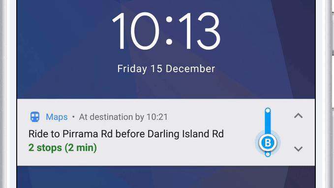
Google Maps will now tell you when to get off the bus or train
A mass transit feature for the Android version of Google Maps that notifies you when you need to get off the bus is finally live. It also includes step-by-step navigation, departure times and ETAs for your next public transportation ride. You can also track your progress as you go, just like you can when walking, biking or driving.

Google Maps will wake you up when you need to get off the bus
Google Maps will make taking the train or the bus in places you're visiting a lot less stressful: according to TechCrunch, the app will soon guide you through every step of a mass transit ride, including telling you when it's time to get off. Once the feature rolls out, you'll apparently find a "start" button at the bottom of the screen when you look up how to go to a certain destination. If you tap that button, you'll get live updates on where you are as you walk or as your ride moves, not only within the app, but also on your Android lock screen.

LiDAR strips landscapes down to their bare glory
LiDAR is having a moment right now helping self-driving cars and robots not hit things, but don't forget about what else it can do. In a study called The Bare Earth, scientists from the Washington Geological Survey used it to image the ground right down to dirt and rocks. Stripped of trees and other distractions, the images provide not only valuable geological survey data, but stunning, otherworldly views of our planet.
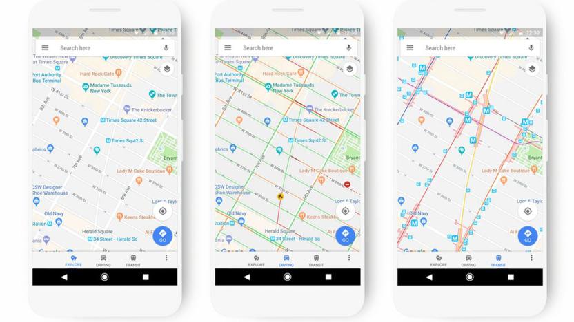
Google Maps' new look adapts to how you travel
Google Maps may be a cornerstone of navigation for many people, but its visual presentation can occasionally leave something to be desired. Why would you care about gas stations when you're taking the subway? To that end, Google is giving Maps a fresh look that adapts to your travel methods and what you're looking for. If you're taking public transportation, it'll highlight stops and route lines; if you're exploring the area, it'll focus more on points of interest. Each location type will have distinct colors and icons, too, so it should be easier to find a restaurant or movie theater if you're new to the area.


