navigation
Latest
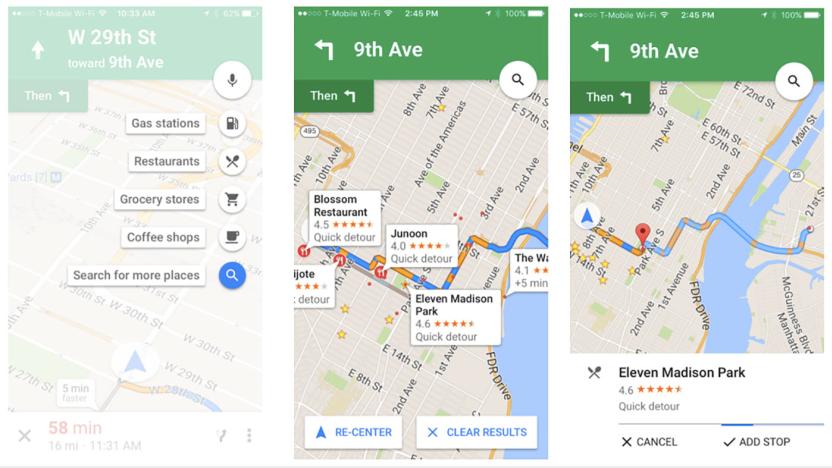
Google Maps pit stop feature arrives on iOS
Back in October, Google Maps rolled out a new feature for finding pit stops along your route. Today, the handy tool is making its way to the iOS version of the app. If you missed the news the first time around, the feature allows you to add a detour to your road trip without leaving navigation mode. Tap the magnifying glass in the top right and you'll be given a list of options like gas stations, restaurants and more. If you need to search for something else, you'll be able to do so. You can also use voice search to find a specific place or another category. You know, so you don't have to futz with your phone too much.

Mitsubishi uses sound and WiFi to locate you indoors
There have been many attempts at locating you indoors when GPS fails, but they usually come with catches. WiFi alone isn't very accurate, for example, while a ton of beacons isn't always practical. Mitsubishi may have a good answer to those problems, however: using two techniques at once. It just developed an approach that determines your location based on the time it takes for sound to reach positioning-capable WiFi access points. It's accurate to within 3.3 feet, and it works with as few as three hotspots -- which, of course, can get you online at the same time as they get you from A to B.

Google gives My Maps for Android a much-needed revamp
Google's My Maps for Android hasn't received a lot of affection lately, but the company is making up for that in style. It quietly released a big upgrade to the custom mapping app that, on top of a "new look and feel," throws in features that arguably should have been there ages ago. You can see Street View imagery for all your map points, to start with -- you'll know what your destinations look like on the ground without having to jump to Google Maps. You can also see photos and videos that were added on the web, and the app should be much faster as a whole. Give it a spin if you're planning a big trip, or just want to document your favorite haunts.

Lyft taps Google's Waze maps to make rides more efficient
Looking to keep pace with Uber, Lyft set out to improve the overall experience for both drivers and passengers. Today, the transportation service announced a "first-of-its-kind partnership" with Google's Waze. Using the Waze Transport SDK, Lyft says it'll make its service more efficient for folks offering rides and eager customers looking to secure one. With Waze's real-time route updates, drivers will be matched with another pickup on their way to a destination. This should cut own on wait times once you hail a car in the app.

Garmin bike headset warns about traffic behind you
There are already bike-friendly smart headsets that will tell you how you're doing, but they won't usually say much about traffic. How are you supposed to know when a car is getting uncomfortably close? That's where Garmin thinks it can help. As part of a larger CES launch, it's unveiling a Varia Vision headset that not only gives you vital cycling data (directions, notifications and performance) but also teams up with the Varia Rearview Radar to warn about traffic behind you. In other words, you'll know about trouble right away, without losing focus. It won't be cheap when it ships this quarter for $400, but it could be justifiable if you regularly bike on busy streets.

GPS top hat uses directional sound to show the way
Never mind pulling out your phone to get directions to the pub... how about some fine headwear? A team of Cornell University students has developed a GPS-enabled top hat that relies solely on directional sound for navigation. It uses a mix of amplitude and phase shifting to make it seem like audio cues are coming from the direction you're supposed to be going. The prototype may look ludicrous, but it's both hands-free and language-free -- you don't need to wait for instructions before turning down a side street.

Microsoft updates navigation headset for the blind
In 2011, Microsoft UK teamed up with charity Guide Dogs to create 'Cities Unlocked,' an organization that worked to create a headset designed to help the visually impaired. That device came last year, but now it's received some major hardware and software upgrades. Although the original simply used bone conduction to send audio clicks and cues to guide the user around, the latest iteration is less of a practical tool and more of an information-rich service. It uses something called "3D soundscape technology," which is kind of like a GPS that describes everything that's around them, from local cafés to alerts telling them when a bus or train is approaching the stop.

Researchers discover the source of animals' natural compasses
For years, biologists have pondered how so many members of the animal kingdom -- from fruit flies and pigeons to sea turtles and wolves -- are able to navigate long distances apparently by sensing the Earth's magnetic field. Two theories have emerged in recent years: one that the ability derived from iron-binding molecules, the other that it came from a protein called cryptochrome. Now a team from China's Peking University have discovered that both theories describe complimentary aspects of the same bio-navigational system.

Uber signs up TomTom to provide navigation for its drivers
After losing out to a consortium of Germany's biggest car makers over the purchase of Nokia's HERE Maps, Uber has set about building its own mapping and navigation services. They're not quite ready for prime time, so the company has had to rely upon a number of popular mapping services, including Google (which also serves as an investor), to help both users and drivers understand exactly where they are. Today, Uber has added TomTom to the list, with the Dutch company confirming that it will also support the private hire taxi firm.

Google Maps for iOS speaks out traffic warnings while you drive
If you're carrying an iPhone, Google Maps just got much more helpful in those moments when you're determined to avoid gridlock. As on Android, Maps' iOS app now speaks out traffic warnings in navigation mode. You'll get a verbal summary of conditions before you start moving, and alerts for any congestion or crashes while you're on your way. Is this a simple addition? You bet -- but it could mean a lot if it helps you take a detour.

Flywheel gives taxi drivers an Uber-like app of their own
Flywheel has helped drag taxis into the modern era through app-based hailing. However, that modernization usually stops in the cab itself -- your driver's gear is antiquated next to the phone-based tech in a Lyft or Uber car. Taxis are about to catch up, though. Flywheel has launched TaxiOS, a platform that replaces the dispatch, meter, navigation and payment systems with phone-based software. It not only streamlines the overall experience for both you and the driver (no matter how you're paying), but marks the first instance of GPS-based metering in licensed taxis. In theory, you're getting both a more accurate fare and fewer rude surprises.

BeeLine brings easy GPS navigation to your bike
It's easy to get navigation on your bike through dedicated GPS or a smartphone cradle, but that doesn't mean that navigation is easy. How are you supposed to pay attention to turn-by-turn directions when you're busy dodging potholes? BeeLine thinks it can help. It's crowdfunding a navigation device that purposefully simplifies your directions down to an arrow and the distance left to go -- it's like a compass that points only to your destination. You don't have to squint at the display to figure out where you're going, and there's no pressure to follow a specific path when you're content to take a leisurely route. The puck-like design is small enough to clip on to your keys (and thus less likely to be stolen), and its e-paper screen helps the battery last for a month's worth of riding.

Simulated brain cells give robot instinctive navigation skills
A team of researchers at Singapore's Agency for Science, Technology and Research (A*STAR) announced on Wednesday that they had taught a robot how to navigate on its own, in much the same way that humans and other animals do. They reportedly accomplished this feat by digitally replicating two types of neurons that help animals geolocate naturally.

Four-legged bot uses drone sidekick to avoid rough terrain
Even with a sure-stepping robot like DARPA's Big Dog, there is still plenty of terrain that today's robo-mules simply can't handle. That's why a team of researchers from ETH Zurich's Autonomous Systems Lab has devised a way to ensure these robots never get bogged down by impassible terrain: pair that robot with a forward-scouting UAV.

China gives its homegrown GPS rival another big push
Alibaba has teamed up with Norinco, a Chinese arms manufacturer, to roll out global positioning services using China's homegrown alternative to GPS. The two companies have sunk roughly $310 million into a new joint venture that'll harness Beidou's navigation satellites to provide mapping data to local businesses. It's another big step on the road to the country ending its reliance upon GPS, and comes two years after the service was opened up to heavy-duty transport vehicles and smartphones. It may not affect us outside of Asia-Pacific just yet, but with Beidou set to become available for all global users by 2020, it's worth keeping an eye on how good this new-fangled offering turns out to be. [Image Credit: ChinaFotoPress via Getty Images]

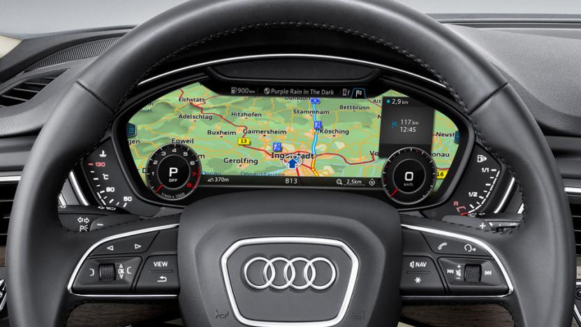
Android Auto update puts music and directions up front
Given that users are operating heavy machinery, tweaking a car system interface is a delicate act. As such, Google has made some subtle changes to the Android Auto home screen in the latest update to show "ongoing activities like music and navigation at a glance." You can now access music playback controls directly from the homescreen -- before, you could see which song was playing but needed to go to another screen to pause it. Navigation is also expanded on the home screen to show turning directions without forcing users over to the main app.
Audi, BMW and Daimler are poised to buy Nokia's Here mapping
What little hope Uber had of buying Nokia's Here mapping service just went out the window. A Wall Street Journal source claims that Audi, BMW and Daimler have tentatively agreed to buy Here for the equivalent of $2.7 billion. A final agreement could be ready within the "next few days," the tipster says. The German automakers won't hoard the navigation technology all to themselves, though. Instead, they'll reportedly give other vehicle brands a chance to claim their own stake and democratize the platform. While Here already has a presence in about 80 percent of the industry, this would make it a true mainstay for in-car mapping -- companies wouldn't have much incentive to license map data from the likes of Google or TomTom.

Google Maps to include US highway railroad crossings (updated)
US Railway crossing accidents are up sharply over last year, but the Federal Railway Administration (FRA) is about to get some high-tech help. Google's Maps will eventually include numerous public and private highway rail crossing locations across the nation. The app will also give drivers navigating with Maps audio and visual alerts when they approach those spots. The FRA said that 270 people were killed in rail crossing accidents in 2015, 48 more than last year. They speculated that, ironically, the increase may be partly due to inattention caused by increased smartphone use on roads.

Uber poaches former Google Maps chief for its self-driving car project
Uber's poached plenty of robotics experts from Carnegie Mellon and now we know who it's snagged to lead that team to produce something worthwhile. According to Re/code, Uber's new Advanced Technologies Center will be led by former Google VP Brian McClendon, a 10-year veteran of the company. The name may not ring a bell, but McClendon is most famous for co-founding the startup that eventually became Google Earth before making Google Maps what it is today.

Google Maps delivers destination info, voice directions while offline
Sometimes you still need navigation and destination info when you're offline. Google is delivering just that with offline Maps. Even when you're not connected (or in airplane mode), the app will still provide information on places in your searches. This means that you can browse hours, reviews and other important details for places like museums and restaurants. What's more, voice-guided turn-by-turn navigation is included as well for maps that you've saved for offline use. Unfortunately, there's no word on when the new tools will arrive other than a vague "later this year." Don't miss out on all the latest news and updates from Google I/O 2015. Follow along at our events page.


