navigation
Latest
Microsoft's navigation tech for the blind is now an app
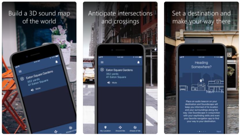
Microsoft has been working on its 3D soundscape technology for years. In 2014 it developed a bone-conducting headset to help visually impaired people navigate around cities using audio cues, and now that technology is available in app form, allowing users to pinpoint their location and identify areas of interest using only their phones and a stereo headset.
MIT CSAIL’s drone is never quite sure where it is
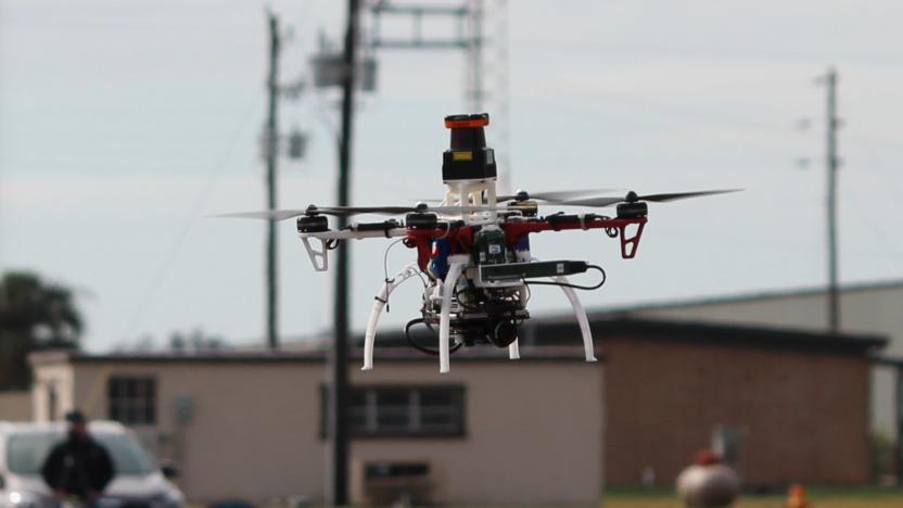
The current generation of autonomous drone navigation and flightpath planning systems are almost too precise, demanding hundreds of measurements be taken so that the UAV knows exactly where it is in space at any given moment. And if those readings are off by even a little, then the drone is in for an impact. What's more, all that data collection is computationally intensive -- especially for smaller drones where the space and weight capacities are limited.

NASA is investigating X-Ray navigation in space
X-rays aren't just for investigating artworks or photographing black holes. NASA scientists just used them to demonstrate a new technique: Navigating the stars. In an experiment, equipment mounted on the International Space Station measured radiation beamed out from distant neutron stars in millisecond pulses -- and by timing their arrival, future spacecraft could find their location from deep space.
Waze's crowd-sourced traffic info comes to Ford Sync 3 cars
In 2016, Ford wisely decided to offer Apple's CarPlay and Android Auto on all its Sync 3 infotainment system-equipped 2017 vehicles, and owners are seeing more benefits from that at CES 2018. Ford announced that it now supports Waze's traffic and navigation app directly from your iPhone. After you plug it into any of the vehicle's USB ports, the app will appear on the Sync 3 touchscreen, letting you control it from there or use voice commands.

New Jersey town will close streets to fight navigation app traffic
It's no secret that some communities hate traffic-savvy navigation apps like Waze with a bitter passion. A congested highway can send legions of commuters down streets that clearly weren't meant for more than a handful of cars at any given time. And one town has apparently had enough. The New York Times has learned that Leonia, New Jersey will close 60 streets to everyone but residents and workers at peak driving periods (6AM to 10AM and 4PM to 9PM) from January 22nd onward. If you're using a nav app, the town may effectively cease to exist at rush hour.
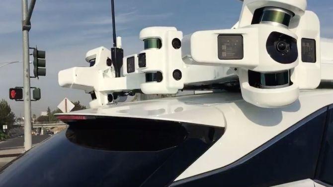
Apple’s self-driving cars could use routes others have traveled
Apple has been working on some sort of autonomous car for a while now. The system — apparently an add-on to existing vehicles — has been seen in a research paper back in November. More plans appeared in a presentation by Carnegie Mellon professor of AI Ruslan Salakhutdinov this month. Now, according to a patent discovered by Autoblog, Apple's 2015 application for an autonomous navigation system has just been published.
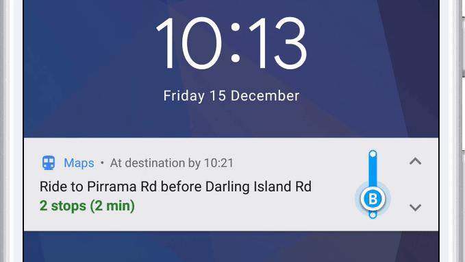
Google Maps will now tell you when to get off the bus or train
A mass transit feature for the Android version of Google Maps that notifies you when you need to get off the bus is finally live. It also includes step-by-step navigation, departure times and ETAs for your next public transportation ride. You can also track your progress as you go, just like you can when walking, biking or driving.
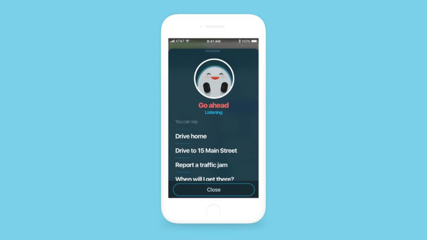
Waze adds hands-free navigation to keep your eyes on the road
Waze has a number of measures to reduce distractions and keep your eyes on the road ahead, but there has been one inescapable distraction: you usually have to touch the screen to get things done. That's a problem, especially in areas where distracted driving laws make it illegal to poke at your phone while on the move. It shouldn't be a problem for much longer. Waze's latest update includes a hands-free navigation option that lets you handle most tasks using only your voice. Say "OK, Waze" and you can navigate to a destination or report a traffic jam without losing focus.
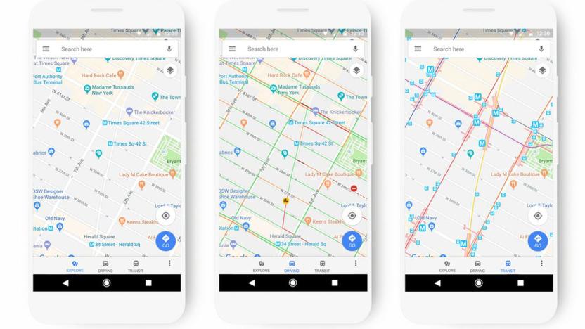
Google Maps' new look adapts to how you travel
Google Maps may be a cornerstone of navigation for many people, but its visual presentation can occasionally leave something to be desired. Why would you care about gas stations when you're taking the subway? To that end, Google is giving Maps a fresh look that adapts to your travel methods and what you're looking for. If you're taking public transportation, it'll highlight stops and route lines; if you're exploring the area, it'll focus more on points of interest. Each location type will have distinct colors and icons, too, so it should be easier to find a restaurant or movie theater if you're new to the area.
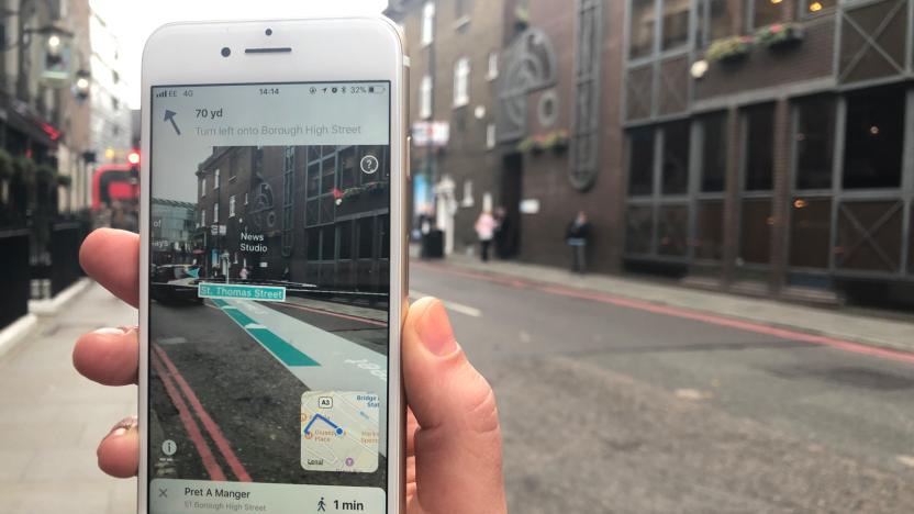
AR navigation app promises better accuracy than GPS alone
You may have seen augmented reality navigation before, but the arrival of AR-native frameworks is making it considerable slicker and more accessible. Case in point: Blippar. Its just-launched AR City app for iOS uses Apple's ARKit to clearly outline where you have to walk, and highlights nearby points of interest based on what you can actually see. And more importantly, it promises to be more accurate than GPS alone. The app uses visual inertial odometry (that is, interpreting movement seen through the camera) to minimize distance errors and prevent you from turning on to a side street by mistake.

Lyft drivers won't have to switch apps to use Google Maps
If you've taken enough Lyft rides, you've probably noticed that drivers have to switch to a navigation app before they start driving. It'd be nice if they could just get going, wouldn't it? They will now: Lyft has added built-in Google Maps navigation to its driver app. Once you've buckled up, your drivers can take you to your destination with the same app they used to pick you up. Google Maps is only available in the Android version of the app right now, but it's "coming soon" for iPhone-toting drivers.
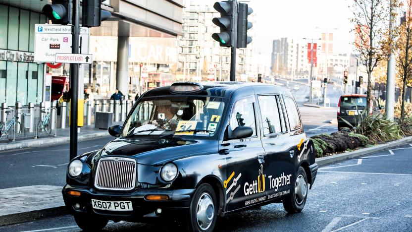
Gett is using Citymapper data to plot new ride-sharing routes
London's public transport system is pretty robust, with plenty of Tubes, buses and overground lines zig-zagging across the city. At rush hour, though, squeezing onto a crammed DLR carriage can be a total nightmare. One alternative is a taxi-hailing app like Gett, which for some time now has been pushing Gett Together, a ride-sharing service that operates on preset routes across the city. Today, the company is announcing Black Bus 1, a new route that operates between Highbury & Islington and Waterloo. The expansion is notable because it was designed using data supplied by mobile navigation app (and now bus route operator) Citymapper.

Google's new Street View cameras help AI map the real world
Google's Street View cameras haven't changed significantly in 8 years, and that's a problem when the technology world most certainly has. How is the company supposed to fulfill its AI ambitions with 2009-era hardware? Thankfully, it won't have to. Google has revealed to Wired that it's implementing a brand new camera design that should not only produce higher quality Street View imagery, but will prove crucial to Google's use of AI to index real-world locations.
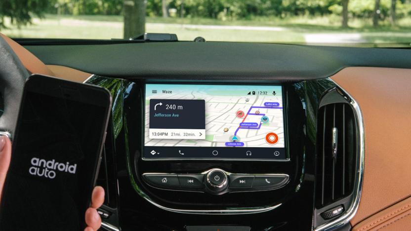
Waze joins Google Maps on Android Auto
Google Maps has become the de facto way to get from point A to point B. But for commuters and Uber/Lyft drivers, Waze -- with Google's transit information overlaid and crowdsourced data -- has become invaluable. The only problem is that while Google Maps is part of Android Auto, Waze still requires you to stick your phone to your dash/windshield. That is, until now.

Google is making 360-degree cameras Street View-ready
It can be a pain to upload your own Street View photos even if you have a 360-degree camera. You may have to stop to take photos every few feet, and then there's the question of getting the spherical shots from your camera to the internet. Google thinks it can help. It's working with hardware partners on "Street View ready" standards that will certify 360-degree cameras based on how easily you can post shots. Street View mobile ready devices let you post directly from an app, with no PC required; auto ready cameras, meanwhile, are designed for capturing high-accuracy shots from your car. VR ready cameras collect the geometry you need for (what else?) virtual reality and connected 360-degree shots, while workflow ready cameras come with publishing tools that upload directly to Street View. In at least some cases, uploading is just a matter of recording some footage (even on the move) and loading an app.
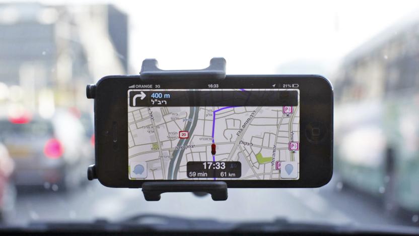
Narrate your own commute with Waze Voice Recorder
You think you're better at giving directions than John Cleese and Arnold Schwarzenegger? Well now's your chance to prove it with the "Waze Voice Recorder". Waze debuted the new feature on Monday, though it's currently only available on Android and there's no word on when it will be ported to iOS.
Windows 10's upgraded mapping helps you plan elaborate routes
You likely know that Microsoft packed a lot of improvements into the Windows 10 Creators Update, but there are still a few surprises left... particularly if you use Windows' built-in navigation app to get from A to B. Microsoft has detailed Creators' numerous Maps upgrades, many of which revolve around planning trickier routes. For one, you can create multi-stop routes. That's nothing new if you use Google Maps, but it's a big deal any time you use Microsoft's default tools.

Uber drivers no longer need other mapping apps
Few of us think about the driver experience when we hail an Uber. We open the app, summon a car and then clamber into the backseat, peering at our phones or talking to friends until we arrive at our destination. But for a trip to work seamlessly, it's important that your chauffeur knows exactly where you are and where you're going. With this in mind, the company has set out on a major revamp of its driver app, improving navigation on iOS and, for the first time, offering turn-by-turn directions in Android.
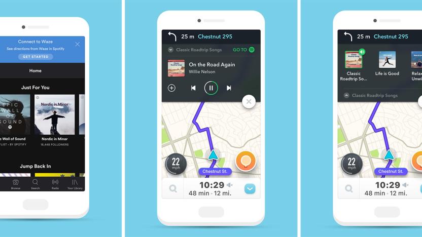
Spotify integrates itself into Waze (and vice-versa)
Drivers use their smartphone for both navigation and music, so why not put the two together? Waze and Spotify have announced that they've done just that: You can now navigate with Waze within Spotify and access Spotify playlists from Waze. After you set up a playlist, it will automatically play when you start your journey, while letting you "easily" change songs. At the same time, you can browse playlists (and switch from one app to the other) when your vehicle is at a full stop.

Google Maps warns you about parking woes before you leave
A parking difficulty icon popped up in an Android beta for Google Maps earlier this month, but now the feature is officially rolling out. However, there are a couple of caveats. First, the parking warnings are only available in the Android version of Google Maps for now. The new tool will also only warn you about potential parking headaches in 25 US metro areas.


