googlemaps
Latest
Google Maps can find wheelchair-accessible routes
Google announced today that Maps is getting a new feature aimed at helping those in wheelchairs or people with other mobility restrictions. While lots of people rely on apps like Google Maps to help them get where they're going, they're not always so useful when it comes to finding wheelchair-accessible routes. But now, Google is launching a feature that will let users select a route that can accomodate wheelchairs and it's rolling out now in London, New York City, Tokyo, Mexico City, Boston and Sydney.

Google opens Maps to bring the real world into games
Pokémon Go and other games that use real-world maps are all the rage, but there's a catch: they typically depend on semi-closed map frameworks that weren't intended for gaming, forcing developers to jump through hoops to use that mapping info. Google doesn't want that to be an issue going forward. The search firm is both opening its Maps platform's real-time data and offering new software toolkits that will help developers build games based on that data.

Apple Maps now includes bike-sharing locations in 179 cities
Apple and Ito World have partnered to bring bike-sharing dock information to Apple Maps, TechCrunch reports. Now, in a number of cities, users can just type "bike sharing" or the name of a bike-sharing service into the Apple Maps search bar and it will show you all of the nearby docks as well as the bike-sharing service's website and phone number. Ito World's bike share data feed currently includes information for 179 cities in 36 countries.

Google sells restaurant review service Zagat
Google bought Zagat in 2011 with hopes of offering definitive restaurant reviews in its search results, but that dream is ending quietly. True to the rumors, Google has sold Zagat to The Infatuation, a restaurant discovery platform. The new owner will keep Zagat as a separate brand and increase its exposure while helping it with a "tech-driven platform" that provides a "more meaningful alternative" to crowdsourced review sites like Yelp. The terms of the deal aren't public, although Google bought Zagat for $151 million.
Google Maps for iOS adds easy access to traffic and transit info
Over a year ago, Google updated its Maps app for Android, making it easier for users to search for restaurants, check out nearby traffic and find public transit schedules. Today, that update is now available for iOS users. With the update, Google Maps users will see three options on the bottom of their screens -- explore, driving and transit.

What we're using: Google Maps while lost in Japan
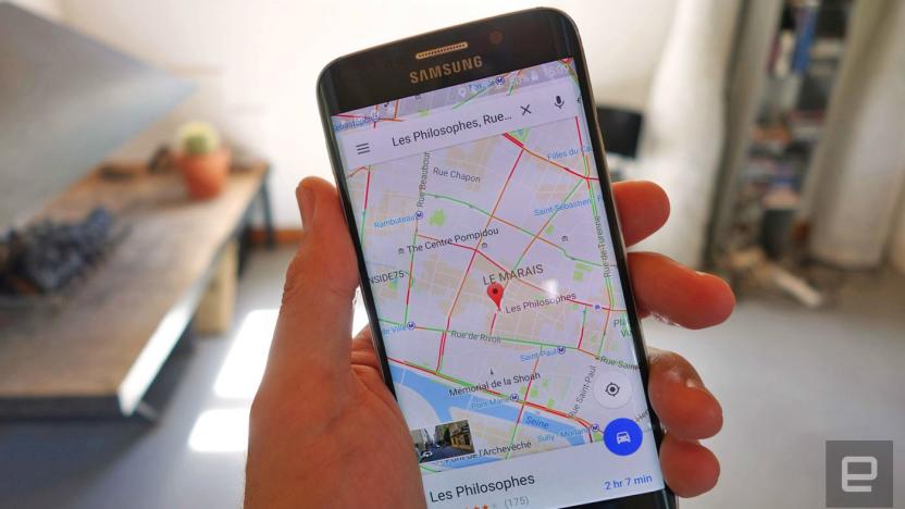
This month, Associate Editor Mariella Moon humblebrags about her vacation to Japan. But that's not what she's going to discuss. Hailing from a country where Google Maps is lacking in detail (and metro details), she didn't expect much. However, even after installing several rival map and guidance apps, it turned out that Google knew best when it came to directions in Tokyo's spaghetti subway -- and even offered a price estimate. The mapping service is moving fast, but it also brings into focus all the work Google still has left to do elsewhere.

Google Maps may let you share your battery life status
Ever wanted to know if someone made it home safely, but didn't know if they had enough battery life to stay in touch along the way? You might not fret quite so much about it in the future. Android Police has spotted code in a Google Maps beta for Android that hints at sharing your remaining battery life alongside your location. You'd only get a generic range (likely because charge levels can change minute-to-minute), but this could be helpful if a friend's phone is running low on their way home from a night out.

Google opens Maps Go beta to US-based testers
You can now take the lite version of Google Maps for a spin if you're in the US. Google has opened the beta version of Maps Go to US beta testers, giving you a way to look up directions or transit info even if you're an area with poor connection. Google launched Android Oreo Go December last year, but Maps Go didn't become available until mid-January. It was only compatible with very, very few (mostly Oreo Go) devices, though, and availability was limited to a few locations. Android Police has noticed the rollout first and has managed to install it even on regular non-Go Android phones.
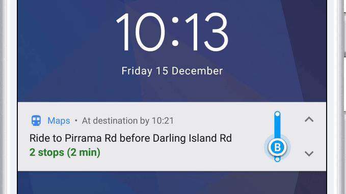
Google Maps will now tell you when to get off the bus or train
A mass transit feature for the Android version of Google Maps that notifies you when you need to get off the bus is finally live. It also includes step-by-step navigation, departure times and ETAs for your next public transportation ride. You can also track your progress as you go, just like you can when walking, biking or driving.

Google Maps will wake you up when you need to get off the bus
Google Maps will make taking the train or the bus in places you're visiting a lot less stressful: according to TechCrunch, the app will soon guide you through every step of a mass transit ride, including telling you when it's time to get off. Once the feature rolls out, you'll apparently find a "start" button at the bottom of the screen when you look up how to go to a certain destination. If you tap that button, you'll get live updates on where you are as you walk or as your ride moves, not only within the app, but also on your Android lock screen.

Google's Santa hub has you taking 'elfies' around the world
Google has brought back Santa's Village for another year, and this time it's particularly trendy. Fire up the Santa Tracker app on your Android phone and you can play Santa Snap, a game that has you flying around Google Maps to take "elfies" at famous landmarks around the world. Basically, it's Amélie with Santa's helpers in place of gnomes. Other activities will pop up daily between now and December 24th, including a equally of-the-moment AI drawing game (a festive take on Quick, Draw), an elf dance coding game and a virtual snowball fight.
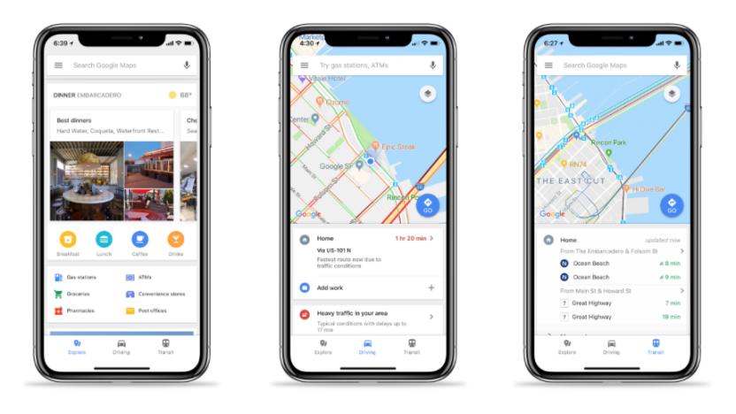
Google Maps' new look adapts to how you travel
Google Maps may be a cornerstone of navigation for many people, but its visual presentation can occasionally leave something to be desired. Why would you care about gas stations when you're taking the subway? To that end, Google is giving Maps a fresh look that adapts to your travel methods and what you're looking for. If you're taking public transportation, it'll highlight stops and route lines; if you're exploring the area, it'll focus more on points of interest. Each location type will have distinct colors and icons, too, so it should be easier to find a restaurant or movie theater if you're new to the area.

Create and share Google Maps lists on the web from your desktop
This past February, Google made it possible to create lists of your favorite local spots in the Maps mobile app. A little later, the company added a sharing feature so you could send your lists to friends and family from your phone. Now Google is bringing the experience to your computer, as well.
Google Maps ditches misguided walking calorie counter
Google is ditching a planned feature for Maps following criticism on social media. The update was tied to directions and displayed how many calories you'd burn if you were to walk to your destination. By clicking on the walking option, you'd even be shown the calories in equivalence to mini cupcakes (of all things). Chances are, the search juggernaut was trying to encourage people to take the active route as opposed to driving. But, its attempt at promoting a healthy lifestyle didn't go down well online. A number of people lambasted the feature on Twitter, claiming it would "shame" and even "trigger" those with eating disorders.
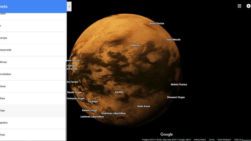
Explore (most of) the solar system in Google Maps
Google first added the moon and Mars to Google Maps back in 2014 to commemorate the Curiosity rover's second year exploring the red planet. Sure, you couldn't zoom down to Street View level, but it's the closest many of us will get to the celestial bodies. If that wasn't enough extraterrestrial fun, Google has answered your prayers: Mercury, Venus, Pluto and ten moons from other planets have been included in the roster.

Lyft drivers won't have to switch apps to use Google Maps
If you've taken enough Lyft rides, you've probably noticed that drivers have to switch to a navigation app before they start driving. It'd be nice if they could just get going, wouldn't it? They will now: Lyft has added built-in Google Maps navigation to its driver app. Once you've buckled up, your drivers can take you to your destination with the same app they used to pick you up. Google Maps is only available in the Android version of the app right now, but it's "coming soon" for iPhone-toting drivers.

Google sources short video clips to go inside Google Maps
Beyond satellite imagery and Street View cars, Google has used Local Guides to add a personal touch to its Maps. Until recently the group of users updated information, uploaded still images and submitted reviews, but a recent email noted that they can also upload video clips (at least from an Android device). According to TechCrunch, the feature has been live for a couple of weeks, allowing Guides to record 10-second video clips from within the Google Maps app, or upload a 30-second video from their camera roll.

Florida Gov: Use Google Maps for real-time road closure updates
Google and Florida have teamed up to make Maps a much more useful resource for the state's evacuation plans in preparation for Hurricane Irma's arrival. Florida Governor Rick Scott has advised residents to use various apps and websites to help them navigate their way if they have to leave their homes due to the category 5 storm expected to hit the state this weekend. One of those apps is Google Maps, and the big G promises to mark closed roads in it as soon as its emergency response team notifies the company.

Google's new Street View cameras help AI map the real world
Google's Street View cameras haven't changed significantly in 8 years, and that's a problem when the technology world most certainly has. How is the company supposed to fulfill its AI ambitions with 2009-era hardware? Thankfully, it won't have to. Google has revealed to Wired that it's implementing a brand new camera design that should not only produce higher quality Street View imagery, but will prove crucial to Google's use of AI to index real-world locations.
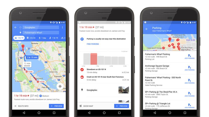
Google Maps will help you park in 25 more cities
Back in January, Google rolled out a "parking difficulty" icon in Maps which, as its name suggests, explains how hard it will be to find a spot for your vehicle. While useful, it was only available in 25 US cities, including New York and San Francisco. Today, it's being expanded to a further 25 locations around the globe: Alicante, Amsterdam, Copenhagen, Barcelona, Cologne, Darmstadt, Dusseldorf, London, Madrid, Malaga, Manchester, Milan, Montreal, Moscow, Munich, Paris, Prague, Rio de Janeiro, Rome, Sao Paulo, Stockholm, Stuttgart, Toronto, Valencia and Vancouver.


