google maps
Latest
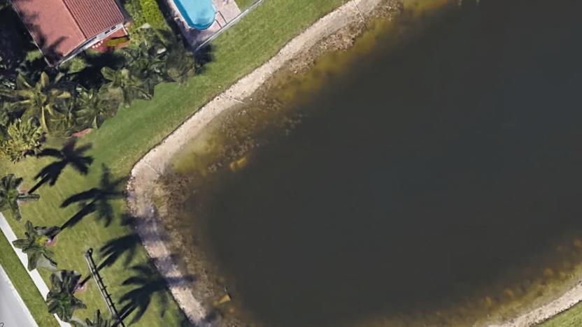
Decades-old missing person case solved with Google Earth photos
The body of a man who had been missing for nearly 22 years was found this week thanks to Google Maps, according to the Sun Sentinel. Remains of 40-year-old William Moldt turned up in a pond located behind a housing development in Wellington, Florida after one of the residents of the neighborhood spotted what appeared to be a vehicle in the water behind his house while looking at Google's satellite images. Police retrieved the remains of the body and positively identified it as Moldt.

Google puts drug addiction recovery info front and center
The opioid epidemic is responsible for tens of thousands of deaths per year. Google hopes to make it easier for the 23 million Americans in recovery to find a support group or find a pharmacy where they can purchase naloxone, the opioid-overdose reversal drug. The tech giant announced today that in honor of National Recovery Month it will be launching two new tools that will help connect recovering opioid addicts with resources.

Google Assistant and Maps are coming to GM vehicles in 2021
GM and Google are working to bring a voice assistant, embedded navigation and in-vehicle apps to Chevrolet, Buick, GMC and Cadillac vehicles beginning in 2021. The companies announced the partnership today, and according to GM, it plans to eventually roll the tech out in all vehicle brands.

Google Maps can help you with the last mile of your daily commute
If your daily commute involves more than just a subway ride from one station to another, Google Maps is about to become a lot more helpful to you. Starting today, Google is rolling out a new feature to the Maps Android and iOS apps that highlights nearby so-called "last-mile" services in conjunction with nearby transit options.
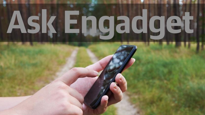
Ask Engadget: What are the best outdoor navigation apps?
The support shared among readers in the comments section is one of the things we love most about the Engadget community. Over the years, we've known you to offer sage advice on everything from Chromecasts and cameras to drones and smartphones. In fact, our community's knowledge and insights are a reason why many of you participate in the comments. We truly value the time and detail you all spend in responding to questions from your fellow tech-obsessed commenters, which is why we've decided to bring back our "Ask Engadget" column. This week's question asks about outdoor navigation apps. Weigh in with your advice in the comments -- and feel free to send your own questions along to ask@engadget.com! I've been doing a lot of hiking and walking outdoors, as well as some bird watching. But Google Maps has turned out to be really unhelpful when it comes to walking directions, especially when it comes to trails in parks. What is the best app for navigating outdoors?
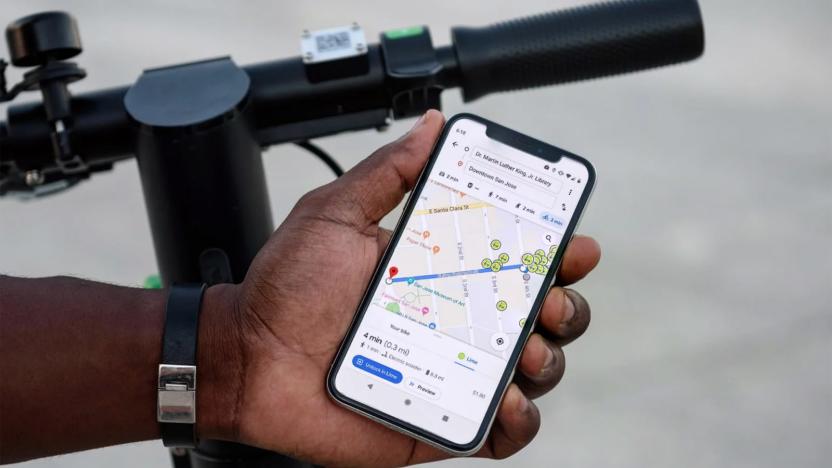
Google Maps gives you more ways to find Lime scooters
Google Maps is making it easier to find a Lime bike or scooter on your own terms. As of today, the Android version of Google's app (iOS is due in the "coming weeks") can help you find Lime rides in the cycling and walking tabs, not just transit -- helpful if your leisurely stroll to work suddenly becomes much more urgent. You'll get detailed info like the time to walk to a scooter, the estimated ride cost, battery range and the all-important ETA. On-foot travelers will receive suggestions for Lime rides as an alternative when it's viable.

Navigation apps still lack railroad safety info the NTSB requested
Your phone's GPS app can alert you when you approach a speed trap or accident -- but will remain silent if you come upon a dangerous railroad crossing. Politico reported that Google, Apple and Microsoft have yet to add information on US railroad crossings to their navigation apps, almost three years after a request from The National Transportation Safety Board (NTSB). The agency asked several tech companies to update their map apps after a 2015 incident in which a truck driver following Google Maps turned onto the railroad tracks and caused a fatal collision. So far, only Garmin and TomTom -- which both make GPS devices -- have complied with the NTSB's demands.

Google Flights will refund the difference if prices drop unexpectedly
Just after shutting down its Trips travel-planning app, Google has announced a raft of travel-related features for other products, including a flight price guarantee. For a limited time, when it tells you prices won't drop on a trip you book through Google Flights, it'll refund the difference if it's wrong and the cost does get lower before you take off.

Google shuts down its Trips travel planning app
Google is killing yet another app, although you might not mind quite as much with this one. The company is shutting down its Trips travel app as of August 5th (that's today, if you're reading in time) in favor of steering users to both its reworked travel search as well as Google Maps. Your information and tools aren't going away -- you will, however, need to look for them in other places.

Cruel Google Maps trick marked livestreamer's mansion as a homeless shelter
While most pranks that originate from YouTube are terrible, a recent one targeted at homeless people in Los Angeles was particularly abhorrent and cruel. According to the Los Angeles Daily News, a group of online pranksters connected with popular YouTuber Paul Denino -- better known by his online handle Ice Poseidon -- created a fake homeless shelter on Google Maps that directed people looking for a place to stay to a private mansion he was renting.

Google’s Android Auto update makes launching and using apps safer
Until recently, infotainment systems were sort-of-useful at best or plagued with horrendous interfaces at their worst. The introduction of Android Auto and CarPlay got automakers to finally start thinking about how people use touchscreen devices. Google and Apple took what they knew about touchscreens, voice assistants and media, creating easy-to-use interfaces.
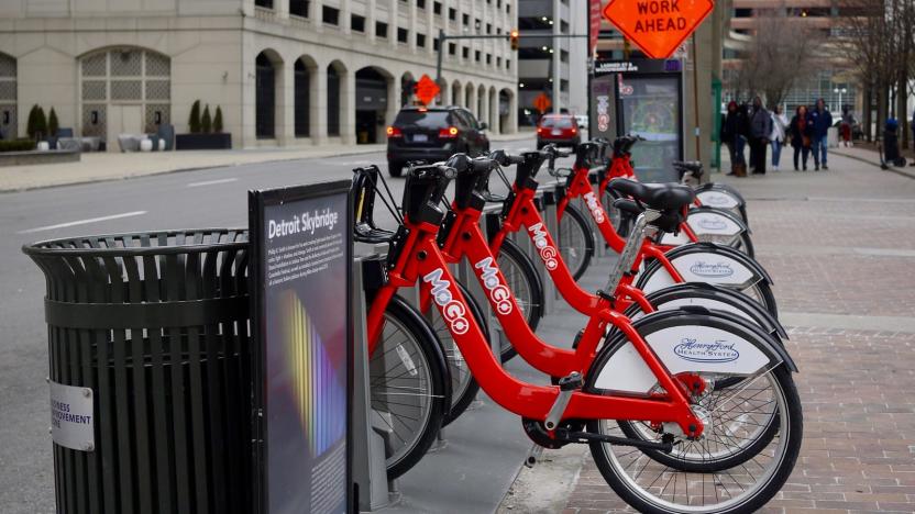
Google Maps now displays bike-sharing locations in 24 cities
Bike-sharing is a convenient way to get around a city, but with so many schemes operating concurrently it's sometimes tough to know where the nearest station with available bikes is. Now, Google can tell you.

Google Maps can predict how crowded your train or bus will be
Public transit is vital for countless people, but no one wants to be stuck on a subway train or bus that's jam-packed. To help you figure out how busy your ride is going to be, you'll soon see predictions to that end in Google Maps. Google is tapping into data from previous rides to predict how packed a bus, train or subway will be.
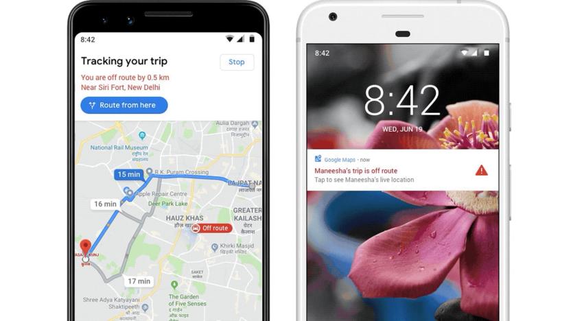
Google Maps can warn you if your ride goes off-route
Many ride-hailing passengers are understandably anxious about their vehicles going off-route due to the potential for sexual assault. However, Google hopes it can set minds at ease until there really is cause for worry. It just introduced optional off-route alerts that let Google Maps users on Android know if their ride veers more than 0.5km (about 0.3 miles) from the suggested route. Enable the feature and you'll get a "prominent notification" as well as a view of where you are relative to the suggested path. From there, you can share your live trip details if you want others to be aware or take action.
WSJ: Google Maps is flooded with 'millions' of fake business listings (updated)
If you've ever tried to find a locksmith on Google in a pinch, this may not surprise you. Turns out Google Maps is filled with millions of scam operations that are impersonating real businesses, according to a new report from the Wall Street Journal. There are currently an estimated 11 million fake business listings on Google Maps, and new listings with false phone numbers or addresses arrive every month.
Google Maps shows your speed while you're driving
Google isn't just counting on speed limits in Maps to encourage safe driving -- it's now showing your actual speed. Android Police has learned that Google Maps is rolling out an optional speedometer that kicks in while you're using driving navigation. It displays next to the current speed limit and changes color if you flaunt the law. Much like a similar Waze feature, you won't have to wonder if you're going too fast.
Google Maps will navigate you away from crises
Google's SOS alerts already give you vital information when you're in a crisis zone, and now that includes driving directions. As part of a broader expansion of SOS alerts to Google Maps, the company has introduced navigation features that will not only warn you about crises along your route, but will change your route to avoid them when possible. If a flood threatens to block your way, this might just help you reach safety.
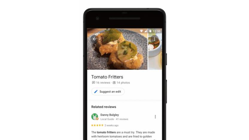
Google Maps AI helps you discover a restaurant's popular dishes
Google is trying to take some of the guesswork out of trying a new restaurant. The company is trotting out an update to Google Maps that uses machine learning to highlight the popular dishes at an eatery. Tap on a place and it'll show the most popular meals in the overview section, with the menu tab showing the most discussed options. If you're curious to know more (and prevent any rude surprises at the table), selecting a dish will show reviews and photos.

Now it's easy to order food in Google Assistant, Search and Maps
Starting today, you'll be able to order food via Google Assistant, Search and Maps in the US. At the outset, Google is working with DoorDash, Postmates, Delivery.com, Slice and ChowNow, with support for Zuppler and more on the way.
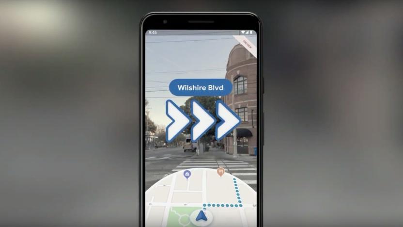
Google Maps' AR walking directions arrive on Pixel devices today
After first showing off augmented reality directions last year, Google is finally starting to roll out the feature for Google Maps. Starting today, Pixel device owners will be able to view walking directions in AR, with arrows appearing in real world environments to show them which direction to go. The company called the feature an "early preview" at Google I/O and didn't provide any details as to when it will arrive on other devices.


