mapping
Latest

Real-time tracking and projection mapping keeps getting better
Japanese creative studio P.I.C.S. have set a mindbending new standard for real-time tracking and projection mapping with their latest visual creation, EXISDANCE. The technology has been around for a while, although it arguably first captured the mainstream public's imagination at the Grammy's last year, when a red bright lightning bolt appeared on Lady Gaga's face during her David Bowie tribute.
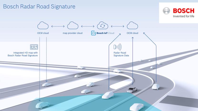
Bosch and TomTom map roads with radar for autonomous vehicles
Bosch and TomTom have come together to create high-resolution road maps based on radar signals. The product of the two companies' collaboration, a system called "radar road signature," is a move towards automated driving.
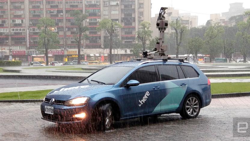
Here's updated mapping vehicle paves way for self-driving cars
It may have been a while since we last we came across a Here 3D mapping vehicle, but that's not to say the company hasn't been using its cars lately. In fact, the Here True collection vehicle is now in its third revision, and I got to hop on one -- based on a Volkswagen Golf Variant 280 TSI Highline -- during Computex. The ride features much faster D-GPS tracking that no longer requires a half-hour calibration (to reach an accuracy of under one meter), along with a Velodyne LiDAR with an accuracy of better than 2cm (within a range of up to 70 meters) and four 16.2-megapixel MARS panoramic cameras. This set of gear is almost identical to what we've seen before, so the real highlight this time is the updated backend to support high-definition mapping.

Google is making 360-degree cameras Street View-ready
It can be a pain to upload your own Street View photos even if you have a 360-degree camera. You may have to stop to take photos every few feet, and then there's the question of getting the spherical shots from your camera to the internet. Google thinks it can help. It's working with hardware partners on "Street View ready" standards that will certify 360-degree cameras based on how easily you can post shots. Street View mobile ready devices let you post directly from an app, with no PC required; auto ready cameras, meanwhile, are designed for capturing high-accuracy shots from your car. VR ready cameras collect the geometry you need for (what else?) virtual reality and connected 360-degree shots, while workflow ready cameras come with publishing tools that upload directly to Street View. In at least some cases, uploading is just a matter of recording some footage (even on the move) and loading an app.
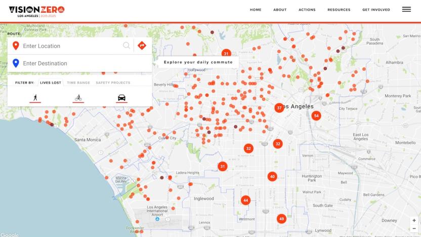
LA fights soaring pedestrian deaths with an interactive map
Open data can be an incredibly powerful tool, but it still requires context and people to actually pay attention to the information for it to be valuable. Los Angeles has discovered this the hard way. Its Vision Zero initiative aims to eliminate traffic deaths by 2025, but compared to other cities with similar programs, LA is coming up short in terms of results. After the program's first full year (2016), fatalities rose by some 43 percent according to the Los Angeles Times. There are a number of reasons for this, including more pedestrian and bicycle traffic, distracted driving and driving under the influence. To combat the rising number, the city looked to data as a means of discerning the most fatal roadways.
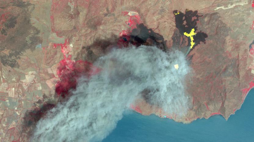
Satellite maps provide a new way to track deforestation
There's no question that deforestation is a problem, as it affects everything from climate through to biodiversity. But gauging the severity of deforestation isn't easy -- simply measuring lost forest cover doesn't tell you the effect it can have on a given area. That's where technology might save the day. Researchers have developed a new technique that uses satellite maps to track forest attrition distance, or the widening gaps between forests that can affect the environment. The overhead data can show whether tree losses are relatively mild, occurring in patches among other trees, or whether they're serious enough to create larger distances between forests.

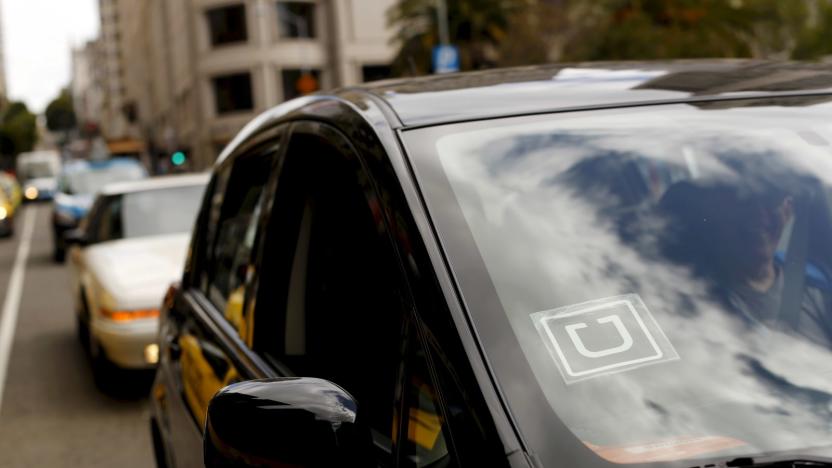
Uber puts mapping cars on five continents
Uber just showed how committed it is to mapping the planet. The ridesharing outfit has started rolling out map cars in Singapore, putting the vehicles on five major continents (sorry, Antarctica, you'll have to wait). As in other cases, the cartographic cars are really driver rides with mapping tech on top to collect data based on real trips. Privacy shouldn't be an issue, Uber says -- they won't keep imagery from the end points of your trip, and what data they do collect won't be made public.

Google brings Foursquare-like favorite lists to Maps
You can now create Spotify-like "playlists" of your favorite local spots on Google Maps that your friends can share and follow. The feature, which Google recently rolled out to Local Guide users, lets you create "Favorites," "Starred Places," "Want to Go" and your own custom lists. The idea is to "start flexing your local knowledge muscles," Google said, and benefit from the inside info of other folks by following their lists.

Google's Street View head moves to Lyft to work on mapping
Lyft is refocusing its mapping efforts with a major new hire: Luc Vincent, who previously founded and led Google's Street View team. As a vice president of engineering at Lyft, Vincent will be in charge of the company's mapping and marketplace divisions, Recode reports. As you'd expect, he'll initially be focused on making the company's real-time map and navigation capabilities better, but he's also planning to improve how Lyft connects drivers and riders. Looking forward, Vincent also hopes to help out Lyft's self-driving initiatives (obviously, maps are a pretty big deal there).

Here Maps is expanding to China with the help of new investors
Here, the mapping company owned by German automakers Audi, BMW and Daimler, plans to bring its products and services to China. To make that happen, it has enlisted the help of three new Asian investors: Chinese internet giant Tencent, digital map provider NavInfo and Singaporean investment firm GIC. They're acquiring a 10 percent stake in Here together, and they're tweaking the company's products to make them ready for the Chinese market.

Apple is reportedly using drones to improve Maps
Apple is putting a team together that will capture mapping data using drones to supplement its camera-equipped minivans, Bloomberg says. While its Maps app is no longer the butt of jokes, Apple reportedly wants to better the quality of Google Maps, an app that's still more widely used on all platforms. The team may use UAVs from companies like DJI and Aibotix to keep maps up-to-date with construction, new roads and other info.

Google timelapses offer a 32-year look at Earth's history
As static as it may seem, Earth is a lively planet that changes almost constantly -- and Google just offered a clever way to see that development with your own eyes. In a partnership with Time, it's introducing a dramatically improved version of Google Earth Timelapse that provides animated satellite imagery covering 32 years, going back to 1984 (4 years earlier than before). It uses the higher-resolution maps you saw in June to provide a look that's both more detailed and more seamless than before, with fewer abrupt changes in color and quality. There's also more to look at in the first place thanks to both added legacy satellite data and info from newer orbiters.

Google Maps will help you avoid Black Friday hordes
For over a year now, Google Maps and Search have been telling people when stores, bars and restaurants are likely to be busy. Now, it's going one step further. From today, searching for a business via Google will not only show you when it's typically crowded, but also an estimation of how busy it is right now. So if you see that a particular store is very full you can plan to head somewhere else. It's hoped that the feature will help users avoid the worst of the crowds over Thanksgiving long weekend, and beyond. There are a couple of other additions rolling out today. Place listings in Search and Maps will now tell you how long the typical stay is at a location, so if you people usually spend two hours at a restaurant, you can plan the rest of your day accordingly. Finally, Maps will now list more complex opening hours. "You'll know what time to pop by the pharmacy at your local drugstore or supermarket, when food delivery begins at a nearby restaurant and what the service hours are at the auto dealership," said Google.

Uber brings scheduled rides to eight more UK cities
Uber's useful ride-scheduling feature is hitting the road and launching in a handful of extra UK cities today. Following a successful launch in London, you can request a driver in Manchester, Birmingham, Bristol, Leeds, Newcastle, Liverpool, Edinburgh and Glasgow up to 30 days in advance. Or rather, you can starting at 4pm. It's a handy option for those extra important trips -- whether you're headed to the airport or an important business meeting, booking ahead of time can give you peace of mind.

Scientists finally made a half-way decent map of Alaska
To protect the Arctic from climate change, scientists require a detailed map which they can slowly update and reference over time. Such a resource has, until now, been difficult to produce because traditional capture methods -- low-flying aircraft, for instance -- are expensive or ill-equipped to deal with the region's harsh weather patterns. That's now changed, however, thanks to a project spearheaded by the National Geospatial-Intelligence Agency (NGA) and the National Science Foundation. Following a directive from President Obama, the group has captured Alaska with a new level of clarity, using commercial satellites owned by Digital Globe.

Waze will help you avoid traffic jams around big events
Navigation apps like Apple Maps, Google Maps and Waze are good for letting you know when you're approaching a traffic jam. Waze is taking that task a bit further with its new Global Event Partner Program. The company is teaming up with organizers of big events like marathons and pro sports to keep you from experiencing unnecessary delays. Those partners will now be able to use the Waze Closure tool to input any scheduled closures ahead of an event. TechCrunch reports that event organizers will be able to add details like turn restrictions, lane reversals, parking locations for more than 65 million users.
Uber reportedly pours $500 million into mapping the planet
It won't surprise you to hear that Uber is improving its maps to offer better pickups and drop-offs, but the ridesharing giant is apparently more committed to the idea than you might think. A Financial Times source understands that Uber is investing a whopping $500 million into its global mapping project, which should eventually provide volumes of ridesharing-specific geographic details. That's no small amount when the company has raised about $13.5 billion over its lifetime.

3D imaging helps map tiny connections in the brain
Mapping brain connections is tricky -- chemicals can destroy the very structures you're trying to map, and an electron microscope can only tell you so much. MIT researchers aren't daunted, however. They've developed a new 3D imaging technique that lets you map the brain at multiple scales, including at resolutions that aren't practical with light-based microscopes. The new approach expands on a conventional chemical-based method of preserving brain tissue samples. If you flood the tissue with acrylamide polymers, you form a super-dense gel that lets you expand the sample up to 5 times its original size without hurting its structure, making it easier to study minute details. Numerous microscopes can study neural structures like synapses at resolutions as fine as 60 nanometers, which beats the 200nm you might get through conventional light microscopes.
NASA gives away the data from an Earth-mapping spacecraft
Want to know a whole lot about the Earth's surface? NASA and the Japanese government are now giving away all the data from the ASTER (Advanced Spaceborne Thermal Emission and Reflection Radiometer) instrument... for free. Previously, you had to pay if you wanted anything more than basic topographical maps; now, you get over 16 years' worth of near-infrared elevation and thermal data. This is mostly helpful if you're a student or a scientist, but it could be worth a peek if you've wanted to see how everything from farms to volcanoes can affect the planet's surface heat.

Inrix Traffic app uses AI to learn your driving habits
It's been awhile since we've heard from Inrix, the company that uses OpenStreetMap and its own traffic analysis to guide you via GPS. It also supplies connected car tech to Lexus, Mercedes-Benz, Porsche and other automakers. The company just completely redesigned its iOS and Android Traffic apps, adding machine learning features, calendar integration and more. While there are tons of such apps to choose from, Inrix's app is geared toward frequent drivers who do routine trips where they often battle traffic.


