Maps
Latest
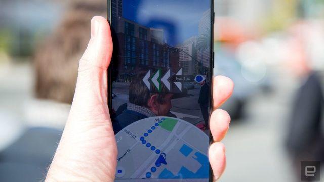
Google Maps adds indoor AR directions and prioritizes eco-friendly routes
Today, the company is unveiling a set of updates that should make the app more helpful in more scenarios. For one thing, it's bringing its AR navigation tool Live View to some indoor locations like select malls, airports and transit stations.

Android users can now shoot and publish their own Street View images
Google has announced that it’s latest Street View beta comes with a tool called connected photos. That lets anyone capture and publish photos from an Android phone, with no need for a fancy 360-degree camera or backpack, let alone an entire car.

Google search now shows you where to vote or drop off your ballot
Google has added a tool to find voting and ballot drop off locations in search and in Maps, helping Americans vote in the 2020 election.
Google Maps' 'Live View' AR feature gets landmarks and improved accuracy
Now, Live View also shows you nearby landmarks. Last month, a Live View location sharing feature became available for Google Pixel users.
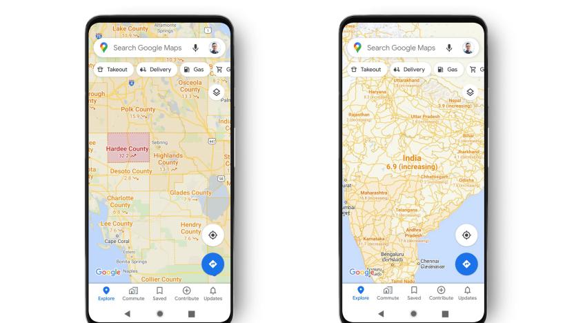
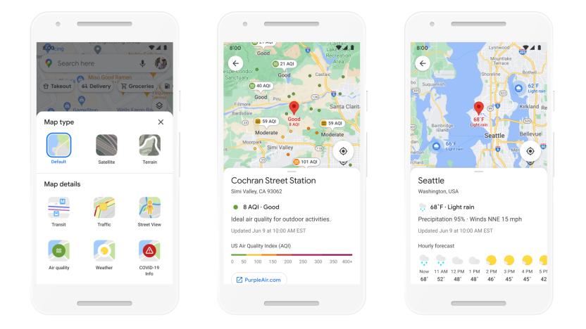
Google Maps now shows you COVID-19 stats
Google has already released a number of COVID-related features on its Maps app, including noting potential transit delays due to the outbreak, the relative busyness of local businesses and tagging the locations of nearby COVID testing sites. On Wednesday, Google announced yet another new feature which will inform users as to whether new cases of the virus are on the rise in the area they want to travel to. Specifically, the company has released a new layer for Maps which displays the seven-day average of new COVID cases per 100,000 people as well as notes whether that infection rate is increasing or decreasing.
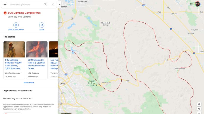
Google Maps is tracking the spread of America's wildfires hour by hour
As wildfires continue to tear through parts of California and Colorado, Google has launched new tools to help people stay informed about their progress. Starting today, Google search queries for information about the fires will turn up more than just news stories and alerts -- they'll also display maps of the fires' boundaries. The Google Maps app will display the same wildfire boundaries to people attempting to enjoy the height of summer nearby, and will also provide warnings and "ambient alerts" to those who begin to approach affected areas.
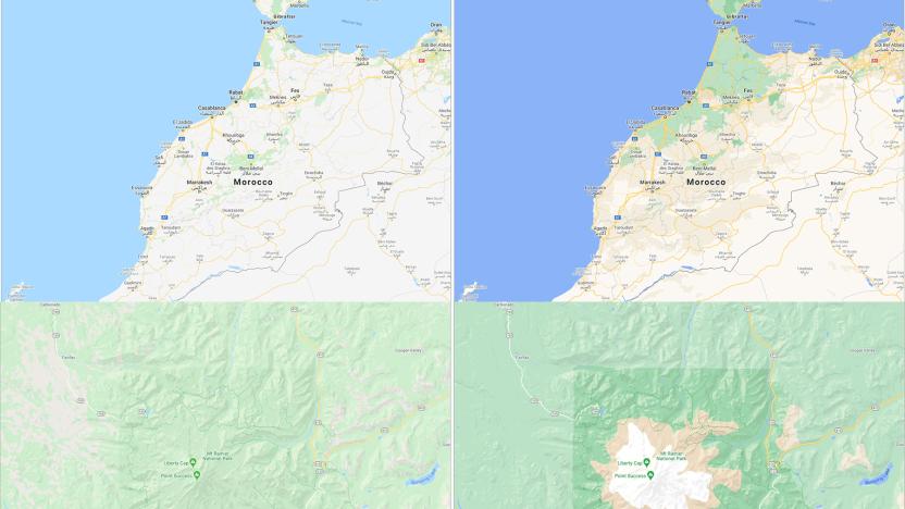
Google Maps update makes it easier to see an area's actual landscape
Google Maps is already one of the most popular services for navigating and remotely exploring the world. Starting this week, though, its default view will be even more colorful and, hopefully, useful for travellers. Google took its satellite imagery and applied some fancy computer vision to accurately identify forests, deserts, rivers and snow-capped mountains.
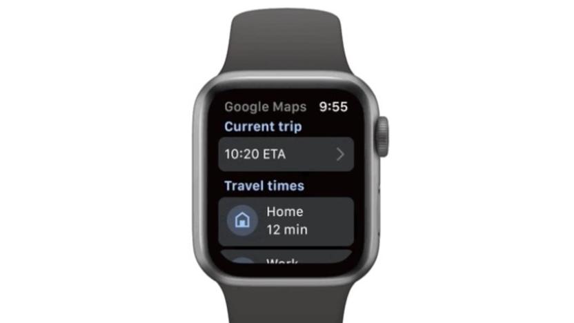
Google Maps is finally back on Apple Watch
Google has two big updates planned for the iOS version of Maps.

Google makes it easier to find Black-owned businesses in Maps and Search
Google is making it easier for buyers and customers to find Black-owned businesses to support. The tech giant has introduced a Black-owned attribute merchants based in the US can add to their profile, so long as they’re verified. Google will then put the new icon alongside any other attribute business owners choose to display on the Highlights section of their profile.
Apple Maps adds EV-focused features and cycling directions
Apple is updating Maps to add much-requested cycling directions, EV charger finding and more detailed maps in other countries.

Almost a fifth of Earth's ocean floor has been mapped
Scientists have mapped nearly a fifth of the Earth's ocean floor, taking a big step forward for everything from biological studies to internet access.

Google tests interactive location listings in Street View
Google is testing an added augmented reality layer in Street View that adds interactive place markers.
Google Maps will highlight accessible locations with a wheelchair icon
A new option in Google Maps will display a wheelchair icon whenever a location you want to visit has an accessible entrance.
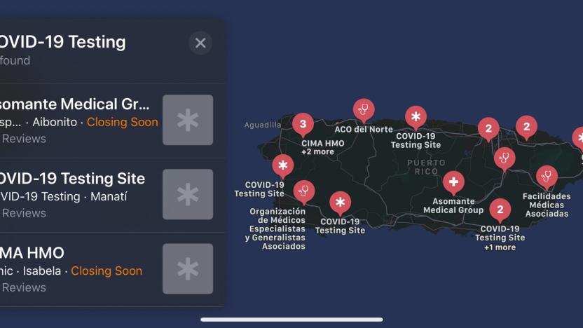
Apple Maps now shows COVID-19 testing sites across the US
Apple Maps has expanded its listings for COVID-19 testing sites to all 50 states and Puerto Rico.
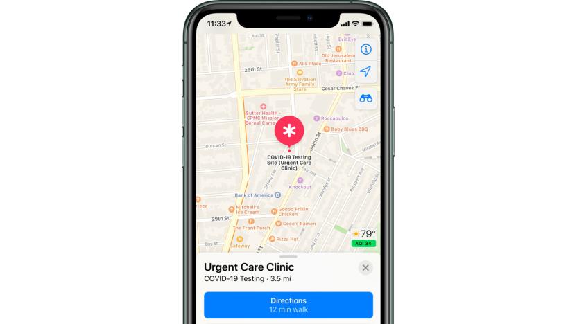
Apple Maps will show COVID-19 testing locations
Apple is asking healthcare providers to display COVID-19 testing locations in Maps, complete with details of what you need before you go.

Google Maps for iOS and Android is getting a makeover
Google Maps was launched 15 years ago this week (in beta, of course). Not surprisingly, Google is using this as an opportunity to launch a few new updates to its massive mapping service. For starters, Maps has a new icon, a four-color take on the location "pin" that has been part of Google Maps for years now. More meaningful to users though are some changes to the Google Maps app that make it a bit simpler and smarter.

Artist creates traffic jams in Google Maps with a wagon full of phones
We tend to think of Google Maps as an indispensable tool that is rarely wrong, but an artist from Germany named Simon Weckert found a humourous way to game the app. Using a wagon loaded with 99 second-hand smartphones, he was able to "hack" Maps to create virtual traffic jams throughout Berlin.

Apple is officially done rebuilding its maps in the US
To say Apple Maps stumbled out of the gate is putting it mildly; it quickly became an internet punchline when it launched in 2012, and left the company with the unenviable job of fixing it. Since then, Apple has been rebuilding the most fundamental part of the experience -- the base maps themselves -- and today the company says it's finally done. Well, in the United States, anyway.

MIT's new GPS system uses satellite images to put you in the right lane
If you've ever used GPS navigation while driving in an unfamiliar place, chances are you've had more than one incident with last minute merging -- likely because the GPS hasn't picked up on the number of lanes on the road, or where they lead to. But this particular annoyance's days could be numbered, thanks to research from MIT.

Huawei will use TomTom for maps now that it's cut off from Google
Now that Huawei is effectively cut off from Google, how is going to provide navigation on its phones? By finding a non-American partner, of course. TomTom has revealed that it struck a deal with Huawei to provide maps, navigation and traffic data for the Chinese manufacturer's apps. The arrangement had been struck a while back, according to TomTom's Remco Meerstra, but hadn't been revealed until now. The company declined to share more details.


